Hurricane Jeanne Intermediate Advisory Number 49a
Issued at: 6:43 PM EDT 9/25/04
Dangerous core of hurricane jeanne approaching the Florida east coast
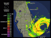
A hurricane warning is in effect along the Florida east coast from florida city northward to st. Augustine, including lake okeechobee. A hurricane warning is also in effect for the northwestern bahamas, including the abacos, andros island, berry islands, bimini, eleuthera, grand bahama island, and new providence. Preparations to protect life and property in the hurricane warning area should be rushed to completion.
A tropical storm warning and a hurricane watch remain in effect from north of st. Augustine northward to altamaha sound georgia.
A tropical storm warning remains in effect for the west coast of florida from east cape sable northward to the ochlockonee river.
A hurricane watch remains in effect from englewood to the suwannee river.
A tropical storm watch remains in effect from south of Florida city around the southern end of the Florida peninsula to east cape sable including Florida bay, and the Florida keys north of the seven mile bridge.
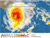
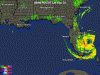
At 7 pm edt, 2300z, the eye of hurricane jeanne was located near latitude 27.1 north, longitude 79.1 west or about 90 miles east-southeast of vero beach Florida.
Jeanne has been moving between the west and west-northwest at 14 mph during the past few hours. A gradual turn to the northwest is expected during the next 24 hours. On this track, the core of the hurricane will reach the Florida east coast tonight. Hurricane force winds are expected to spread inland as much as 100 miles along the track of jeanne.
Maximum sustained winds are near 115 mph with higher gusts. Jeanne is a dangerous category three hurricane on the saffir-simpson hurricane scale. Some additional strengthening is possible before landfall in Florida. Stronger winds, especially in gusts, are likely to occur on high rise buildings.
Hurricane force winds extend outward up to 70 miles from the center, and tropical storm force winds extend outward up to 205 miles. Settlement point on the western end of grand bahama island recently reported a wind gust to 98 mph. A Florida coastal monitoring program wind tower in vero beach recently reported a wind gust to 63 mph.
The latest minimum pressure central pressure reported by a noaa hurricane hunter plane 951 mb, 28.08 inches.
Storm surge flooding of 2 to 4 feet above normal tide levels, along with large and dangerous battering waves, are still occurring near the western end of grand bahama island.
Coastal storm surge flooding of 4 to 7 feet above normal tide levels, along with large and dangerous battering waves, can be expected near and to the north of where the center makes landfall along the Florida east coast. A storm surge of up to 5 feet above the present water level is likely to occur mainly on the east side of lake okeechobee.
Tides of 1 to 3 feet above normal are possible in the warned area along the Florida west coast, possible reaching 3 to 6 feet in areas of onshore flow north of tampa bay.
Rainfall totals of 5 to 10 inches, with isolated higher amounts are possible along the track of jeanne over the northwestern bahamas and Florida.
Isolated tornadoes are possible over portions of the east Florida peninsula tonight.
Repeating the 7 pm edt position, 27.1 n, 79.1 w. Movement toward, west to west-northwest near 14 mph. Maximum sustained winds, 115 mph. Minimum central pressure, 950 mb.
For storm information specific to your area, please monitor products issued by your local weather office.
An intermediate advisory will be issued by the national hurricane center at 9 pm edt followed by the next complete advisory at 11 pm edt.
Issued at: 6:43 PM EDT 9/25/04
Dangerous core of hurricane jeanne approaching the Florida east coast
A hurricane warning is in effect along the Florida east coast from florida city northward to st. Augustine, including lake okeechobee. A hurricane warning is also in effect for the northwestern bahamas, including the abacos, andros island, berry islands, bimini, eleuthera, grand bahama island, and new providence. Preparations to protect life and property in the hurricane warning area should be rushed to completion.
A tropical storm warning and a hurricane watch remain in effect from north of st. Augustine northward to altamaha sound georgia.
A tropical storm warning remains in effect for the west coast of florida from east cape sable northward to the ochlockonee river.
A hurricane watch remains in effect from englewood to the suwannee river.
A tropical storm watch remains in effect from south of Florida city around the southern end of the Florida peninsula to east cape sable including Florida bay, and the Florida keys north of the seven mile bridge.
At 7 pm edt, 2300z, the eye of hurricane jeanne was located near latitude 27.1 north, longitude 79.1 west or about 90 miles east-southeast of vero beach Florida.
Jeanne has been moving between the west and west-northwest at 14 mph during the past few hours. A gradual turn to the northwest is expected during the next 24 hours. On this track, the core of the hurricane will reach the Florida east coast tonight. Hurricane force winds are expected to spread inland as much as 100 miles along the track of jeanne.
Maximum sustained winds are near 115 mph with higher gusts. Jeanne is a dangerous category three hurricane on the saffir-simpson hurricane scale. Some additional strengthening is possible before landfall in Florida. Stronger winds, especially in gusts, are likely to occur on high rise buildings.
Hurricane force winds extend outward up to 70 miles from the center, and tropical storm force winds extend outward up to 205 miles. Settlement point on the western end of grand bahama island recently reported a wind gust to 98 mph. A Florida coastal monitoring program wind tower in vero beach recently reported a wind gust to 63 mph.
The latest minimum pressure central pressure reported by a noaa hurricane hunter plane 951 mb, 28.08 inches.
Storm surge flooding of 2 to 4 feet above normal tide levels, along with large and dangerous battering waves, are still occurring near the western end of grand bahama island.
Coastal storm surge flooding of 4 to 7 feet above normal tide levels, along with large and dangerous battering waves, can be expected near and to the north of where the center makes landfall along the Florida east coast. A storm surge of up to 5 feet above the present water level is likely to occur mainly on the east side of lake okeechobee.
Tides of 1 to 3 feet above normal are possible in the warned area along the Florida west coast, possible reaching 3 to 6 feet in areas of onshore flow north of tampa bay.
Rainfall totals of 5 to 10 inches, with isolated higher amounts are possible along the track of jeanne over the northwestern bahamas and Florida.
Isolated tornadoes are possible over portions of the east Florida peninsula tonight.
Repeating the 7 pm edt position, 27.1 n, 79.1 w. Movement toward, west to west-northwest near 14 mph. Maximum sustained winds, 115 mph. Minimum central pressure, 950 mb.
For storm information specific to your area, please monitor products issued by your local weather office.
An intermediate advisory will be issued by the national hurricane center at 9 pm edt followed by the next complete advisory at 11 pm edt.
") .
. We're all thinking about you.