The Official Hurricane Jeanne thread

Figment1986

Well-Known Member
This is the first time FLA got hit by 3 major Hurricains within a short time period... The location where it has came on, first time in about 100 years it got his by such a storm i heard by my local fox affieliate...

(earlier i said storms... which counts Tropical storms through hurricains.. meaning anything that had been named and hit FLA..)
 

Goofette

New Member
Spectroman2003 said:
I think you people are ridiculous for posting about this so soon. First of all, IVAN isn't completely gone yet and you're already jumping to another. Serioulsly, give it a rest.

I started reading this thread and saw this comment..... :zipit:

I'm watching the Hurricane on TV Live and MSNBC is showing the eye over Melbourne (my time is 3:30 cs), it's at a Cat 3. I'm very worried about all of you. It said it's beginning to hit the Orlando area, but it's going to get a lot worse. Just Stay Safe everyone, I'm thinking about you all and holding my breath that everyone will be ok.
 

PhotoDave219

Well-Known Member
poogy71 said:
I hope that the hurricane won't hurt WDW/Universal/SeaWorld

Stay safe (and if you know anything about the damage the Jeanne make, please tell me)

poogy71
Ahem... .worry about the people, not the parks. Because if the people who work at the parks have no where to live or no longer live, your parks cant open, irreguardless of damage.

Youre asking about damage while the hurricane hasnt completely hit yet? The max winds havent reached us and youre worried about damage? Im worried about my apartment that keeps shaking...
 

LSUxStitch

Well-Known Member
i just wish u guys good luck, im in new orleans and every one on the gulf coast has had its times with hurricanes...it seems that this yr is YOUR yr....and im sorry but good luck!!
 

Tim G

Well-Known Member
Original Poster
Hurricane Jeanne Update

STORM STATUS September 25, 4:40 AM EDT


Name: Hurricane Jeanne
Location: Over The Florida Peninsula About 20 Miles East of Sebring Florida. This Is Also About 45 Miles West-Southwest Of Vero Beach Florida.
Lat/Long: 27.4N, 81.1W
Max Winds: 110 mph
Category: 2
Heading: Just North Of Due West
Speed: 13 mph
Pressure: 28.20 inches
 

Tim G

Well-Known Member
Original Poster
Hurricane Jeanne Advisory Number 51

Issued at: 4:40 AM EDT 9/26/04


Jeanne weakens to a category two hurricane as it passes just north of lake okeechobee, hurricane warning for Florida west coast,

At 5 am edt, 0900z, a hurricane warning has been issued along the west coast of Florida from englewood to the suwanee river. A hurricane warning continues in effect for the Florida east coast from hallandale northward to st. Augustine, including lake okeechobee.

At 5 am edt, 0900z, all watches and warnings are discontinued along the Florida east coast south of hallandale, and along the florida west coast south of chokoloskee, including the Florida keys.

A tropical storm warning and a hurricane watch remain in effect from north of st. Augustine northward to altamaha sound georgia.

At 5 am edt, 0900z, the tropical storm warning is extended westward along the Florida gulf coast to destin. A tropical storm warning is now in effect along the Florida gulf coast south of englewood to chokoloskee, and north and west of the suwannee river to destin. A tropical storm warning is also now in effect north of the altamaha sound to the savannah river.

At 5 am edt, 0900z, the government of the bahamas has discontinued all warnings for the bahamas.

At 5 am edt, 0900z, the center of hurricane jeanne was located near latitude 27.4 north, longitude 81.1 west or over the Florida peninsula about 20 miles east of sebring Florida. This is also about 45 miles west-southwest of vero beach Florida.

Jeanne is moving just north of due west near 13 mph. A gradual turn toward the northwest is expected during the next 24 hours. This motion should bring the center of jeanne across the Florida peninsula to near the tampa bay area later today.

Maximum sustained winds have decreased to near 110 mph, with higher gusts. This makes jeanne a category two hurricane on the saffir-simpson hurricane scale. Stronger winds, especially in gusts, are likely to occur on high rise buildings. Jeanne will continue to weaken as the center moves farther inland. However, winds of hurricane force may occur as far as 100 miles inland along the path of jeanne.

Hurricane force winds extend outward up to 70 miles from the center, and tropical storm force winds extend outward up to 205 miles. A Florida coastal monitoring program tower in sebastien florida recently reported sustained winds of 67 mph with a gust to 81 mph.
Estimated minimum central pressure is 955 mb, 28.20 inches.

Coastal storm surge flooding, along with large and dangerous battering waves, will begin to subside along the Florida east coast. A storm surge of up to 5 feet above the present water level is likely to occur mainly on the east side of lake okeechobee.
Tides of 2 to 4 feet above normal are possible in the warned area along the Florida west coast, and higher at the heads of bays. Tide could possibly reach 3 to 6 feet in areas of onshore flow north of tampa bay.

Rainfall totals of 5 to 10 inches, with isolated higher amounts are possible near the path of jeanne over Florida.
Isolated tornadoes are possible over portions of the central and northern Florida peninsula and southeastern georgia today.
Repeating the 5 am edt position, 27.4 n, 81.1 w. Movement toward, just north of due west near 13 mph. Maximum sustained winds, 110 mph. Minimum central pressure, 955 mb.

For storm information specific to your area, please monitor products issued by your local weather office.

Intermediate advisories will be issued by the national hurricane center at 7 am edt and 9 am edt followed by the next complete advisory at 11 am edt.
 

Tim G

Well-Known Member
Original Poster
Hurricane Jeanne Update

Hurricane Jeanne's 120-MPH Winds Hit The Florida Coast

UPDATED: 5:40 am EDT September 26, 2004


STUART, Fla. -- Hammering Florida with its fourth hurricane in six weeks, Jeanne came ashore with 120-mph winds that ripped roofs off buildings, hurled debris still stacked from previous storms and cut power to hundreds of thousands.

Palm fronds whipped amid waves of horizontal rain as the Category 3 storm made landfall just before midnight Saturday at Hutchinson Island near this Atlantic coast city.It was in almost the exact spot where Hurricane Frances barreled ashore three weeks earlier. Asked if there had been other landfalls that close in place and time, National Hurricane Center Director Max Mayfield said, "First time ever that we know of."

Four hurricanes in one season represented an ordeal no state has faced since 1886, when Texas was the target. And the hurricane season runs through November.Again with Jeanne, fatigued Floridians fled after state officials urged 2 million people to evacuate.
"Before I left home, I prayed over my house and I told God it was in his hands," said Ada Dent, who went to a shelter in West Palm Beach with her 2-year-old grandson.

The storm, which sent debris flying and crashing through deserted streets, was expected to make a turn to the north over central Florida and stay inland over Georgia and the Carolinas through Tuesday. By early Sunday, it had weakened to a Category 2 storm with 110-mph top sustained winds.
Rainfall totals of 5 to 10 inches were expected in the storm's path, and flooding could be a major concern because previous hurricanes had saturated the ground and filled canals, rivers and lakes. Waves that reached up to 20 feet high offshore were also pounding the coast.

The fierce winds left much damage. Roofs were torn off houses, condominiums and other buildings, but only minor injuries were reported early Sunday. In Jensen Beach, the deserted community center was destroyed.
Parts of the waterproof roof covering at Martin Memorial Medical Center in Stuart were blown off, letting some rain seep in, administrative nursing supervisor Sharon Andre said. No injuries were reported.

Elsewhere in Stuart, part of a condominium roof collapsed. One person was rescued.
Earlier, Jeanne tore across the Bahamas, leaving some neighborhoods submerged under 5 feet of water. No deaths or serious injuries were reported there, but the storm was earlier blamed for more than 1,500 deaths in floods in Haiti.
"I really can't believe it's happening all over again -- and right in the same place," said Charity Brown, who moved to West Palm Beach from Chicago three months ago with her children, ages 5 and 3. They hid in a closet as Frances tore the roof off their apartment. That hole is now covered by a tarp, so the family went to a shelter at an elementary school Saturday.
"I'm going to get out of (Florida). It's scary. It's crazy."

In Cocoa Beach about 80 miles north of Stuart, Paul and Ann Jutras weathered another storm in their reinforced house that they claim is hurricane-proof. It's two blocks from the Atlantic Ocean and has two roofs, just in case one is damaged.

In Frances, "we got pounded for 37 hours but the wind would blow for about 20 or 25 minutes and there would be a lull. This one, it's just not letting up at all," Paul Jutras said.
At 5 a.m. EDT Sunday, Jeanne was centered about 20 miles east of Sebring and about 45 miles west-southwest of Vero Beach. It was moving west and slightly to the north at 13 mph.
Jeanne followed Charley, which struck Aug. 13 and devastated southwest Florida; Frances, which struck Labor Day weekend; and Ivan, which blasted the western Panhandle when it made landfall in nearby Alabama on Sept. 16. The storms caused billions of dollars in combined damage and killed at least 70 people in Florida alone.

Officials ran out of time to remove tall piles of debris -- from branches to sodden furniture and building materials -- that remained on neighborhood streets, left over from Frances. Some people took to burning the debris to lessen the amount that could become dangerously airborne.
The storm made even more difficult the formidable job of keeping the lights on in Florida.
Early Sunday, more than 816,000 customers were without power. Officials feared the storm could leave millions without electricity, some for three weeks or more.

Gas stations and businesses were boarded up and deserted, and law enforcement took to the radio airwaves, saying that anyone who was outside their homes after the 6 p.m. curfew Saturday would be jailed.
It was unknown how many of the 2 million people urged to evacuate actually did, but state officials said more than 41,000 people, many with homes already damaged by Frances, were housed in shelters.
LaTrease Haliburton reluctantly checked into a West Palm Beach shelter with her 6-year-old daughter, who has had nightmares since Frances caved in the bathroom ceiling in her family's apartment.
"I want to make sure my daughter isn't as scared this time," Haliburton said.
 

Tim G

Well-Known Member
Original Poster
Hurricane Jeanne Update

Realtime Melbourne Radar

Base Reflectivity 0.50 Degree Elevation Range 124 NMI

(No Comment)
 

Attachments

  • WUNIDS05.gif
    WUNIDS05.gif
    839.9 KB · Views: 151

Tim G

Well-Known Member
Original Poster
Hurricane Likely Is 'Storm Of The Year!' :mad: :mad: :mad: :mad: :mad:

September 26, 2004


Hurricane Jeanne began its brutal march across Florida today, showing no mercy on a state already battered and bruised by three storms in the past six weeks.

Jeanne may be the worst yet, combining the speed of Charley, the size of Frances and the fury of Ivan in one deadly package. Florida has never seen four storms hit in a year.
"It will probably be the storm of the year for the Florida peninsula," said Max Mayfield, director of the National Hurricane Center, near Miami. "It's going to cause extreme damage and loss of life if we're not very, very careful."
The storm was so big that even hours before landfall Saturday, early-evening winds along the coast were toppling small trees, bending street signs in half and ripping tarps from homes damaged during Hurricane Frances.

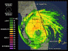
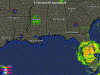
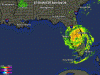
The best-case scenario for Florida disappeared Saturday afternoon, when Jeanne's forecast track took it inland rather than northward offshore.
Forecasters expected the storm would make landfall around midnight Saturday or early today between Palm Beach County and Cape Canaveral as a strong Category 3, which has maximum winds of 130 mph.
But because Jeanne will be crossing over the warmer Gulf Stream, they said there was a chance it could intensify to a minimal Category 4.
The nasty weather -- high winds, heavy rain and possible tornadoes -- should continue to pound the state through all of today.

Residents in St. Lucie and Indian River counties began feeling the effects of the storm by midafternoon.
"They're going to really get clobbered by this hurricane," Mayfield said. "They haven't had a major hurricane in the Fort Pierce-Vero Beach area since 1933."

In Fort Pierce, tropical-storm-force winds arrived by early evening. Street lights and power poles began bending and swaying. Branches, palm fronds and street signs tumbled across roads. Rain fell in a heavy, blinding wall of water.
One Fort Pierce police officer said he saw a mattress blown across a street.
It would be a long night for much of the state.
"We're anticipating nine hours of being battered," St. Lucie County Administrator Doug Anderson said from the county's underground emergency-operations bunker.
That didn't stop many drivers from taking to the roads to sightsee. Nor did it scare many residents of barrier islands into seeking safer ground.
"There are some stubborn people out there that are not leaving the islands," Anderson said. "And they're in danger."

Though millions were ordered to evacuate in advance of the storm, many stayed put -- some even taking a matter-of-fact approach to the storm -- despite the swath of destruction and death it left in the Carribbean.
"Unfortunately, it looks like the people north of Palm Beach County aren't preparing," said Ed Rappaport, deputy director of the National Hurricane Center, who made an afternoon plea for people to either make last-minute preparations or flee.
"This is stronger than Frances, a well-built storm," Rappaport said. "This is where your life is at risk. If you don't act now, you won't get another chance."

In the barrier islands of southern Brevard County, people remained on the streets as sundown approached. In the small beach town of Indialantic, Katherine Bryan planned to remain throughout the storm.
Bryan said she has never left for a hurricane and wasn't going to start this time. She lives in a subdivision within 200 yards of the beach.
"People can't afford to evacuate this time again. Their credit cards are all maxed out," she said. Almost no one in her subdivision was leaving. She looked out over the beach, sand hitting her in the face and foam flying off the water.
"I'm just trying to enjoy what's left of it," Bryan said.

Floridians know the post-hurricane drill all too well: the lack of power, the fallen trees, the closed stores and restaurants.
This time, however, some people may have to brace for extended power outages. Florida Power & Light warned that customers who lose electricity can expect to be without it for three weeks.
FPL and other power companies are all struggling to find enough workers to handle the impact of Jeanne.

There's also the additional concern of flooding. Jeanne was expected to dump 6 to 12 inches of rain across an already-waterlogged region. Many of Central Florida's rivers, retention ponds and canals are filled to the brim.
Until Saturday morning, it looked like Central Florida might escape the worst of the storm. But the track kept moving westward, encompassing an ever-bigger swath of the state.
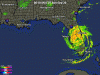
Winds of at least 74 mph were expected to spread as far as 100 miles inland.
"If our forecast is right, there will be hurricane-force winds inland," Rappaport said. "There's a pretty good chance they'll make it to Orlando, maybe as far west as Tampa, possibly as far north as Gainesville."

If so, Orlando will have begun feeling hurricane-force winds in the pre-dawn hours, with winds weakening by mid- to late morning. Then they'll be replaced by tropical-storm-force winds of at least 39 mph that could last all day, until the storm moves well to the north, said Bart Hagemeyer, a meteorologist at the National Weather Service in Melbourne.
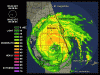
Damage from inland winds in Central Florida could be worse than it was from Charley, Hagemeyer said. That's because Charley's eye was only 5 miles wide, while Jeanne's eye is about seven times that, which would cast the strongest winds over a much broader area. He also noted that Orlando likely will be on the east -- or worst -- side of the storm as it traverses the state.
"That's where the worst winds and the worst rains are," Hagemeyer said. "If there is one glimmer of good news, it's that Jeanne is moving much faster than Frances. That may help the rainfall."

Gov. Jeb Bush promised that the state's response to Jeanne would be immediate, but he also urged Floridians to be patient.
"Even though our resources are stretched, we are well-organized to provide relief as quickly as possible," Bush said, conceding that everyone in the state is "weary" of the succession of hurricanes. "Our resources are strained because of the magnitude of these progressive storms . . . this is going to be a long term effort to rebuild."
The fact that Jeanne is the fourth hurricane to hit the state this year -- and the third to cross Central Florida -- is mind-boggling.

Only Texas has been struck by four hurricanes in a season -- back in 1886. Two of them actually made landfall in Mexico and Louisiana but still hammered the Lone Star State.
"It's historic," Hagemeyer said. "And unfortunately, hurricane season isn't over until the end of November."
 

Tim G

Well-Known Member
Original Poster
Hurricane Jeanne Update

Realtime Gulf Coast Doppler Radar
 

Attachments

  • Florida_anim.gif
    Florida_anim.gif
    325.3 KB · Views: 180

Tim G

Well-Known Member
Original Poster
Hurricane Jeanne Update

Realtime Melbourne Radar

Base Reflectivity 0.50 Degree Elevation Range 124 NMI

(No Comment)
 

Attachments

  • WUNIDS06.gif
    WUNIDS06.gif
    843.4 KB · Views: 143

Tim G

Well-Known Member
Original Poster
Hurricane Jeanne Update

Realtime Tampa Radar

Base Reflectivity 0.50 Degree Elevation Range 124 NMI

(No Comment)
 

Attachments

  • WUNIDS-T01.gif
    WUNIDS-T01.gif
    675.6 KB · Views: 138

MissM

Well-Known Member
HOLY CRAP I'M NERVOUS AT THIS POINT!!

I live in Pinellas county. Current track puts it basically exiting at the Pinellas/Pasco county border. Right over me and my crappy apartment.

We woke up about 7am to sirens. The mobile home complex behind the apartment complex was under mandatory evac (all mobile homes are under mandatory evac). Turning on the weather showed a really bad shift in track and now it looks like we're in serious trouble.

Wide power outages are already being reported in Polk and Hillsborough county. Many more expected in Pinellas, Pasco and related.

Wish us well folks, it's heading straight for us this time.
-m
 

Tim G

Well-Known Member
Original Poster
Hurricane Jeanne Update

Realtime Gulf Coast Doppler Radar

(No Comment)
 

Attachments

  • Gulf Coast_anim.gif
    Gulf Coast_anim.gif
    288.6 KB · Views: 144

Tim G

Well-Known Member
Original Poster
Hurricane Jeanne Update

Realtime Florida Doppler Radar

(No Comment)
 

Attachments

  • Florida_anim.gif
    Florida_anim.gif
    325.3 KB · Views: 144

Tim G

Well-Known Member
Original Poster
Hurricane Jeanne Update

STORM STATUS September 26, 6:58 AM EDT

Name: Hurricane Jeanne
Location: Over The Central Florida Peninsula About 10 Miles North of Sebring Florida. This Is Also About 50 Miles South Of Orlando Florida.
Lat/Long: 27.7N, 81.4W
Max Winds: 100 mph
Category: 2
Heading: West-Northwest
Speed: 12 mph
Pressure: 28.35 inches
 

Tim G

Well-Known Member
Original Poster
Hurricane Jeanne Intermediate Advisory Number 51a

Issued at: 6:58 AM EDT 9/26/04

Jeanne weakens further over the central Florida peninsula, wind gusts to hurricane force in the orlando area

A hurricane warning remains in effect along the west coast of florida from englewood to the suwanee river. A hurricane warning also remains in effect for the Florida east coast from hallandale northward to st. Augustine, including lake okeechobee. Warnings may be discontinued later today along portions of the Florida east coast.

A tropical storm warning and a hurricane watch remain in effect from north of st. Augustine northward to altamaha sound georgia.

A tropical storm warning remains in effect along the Florida gulf coast south of englewood to chokoloskee, and north and west of the suwannee river to destin. A tropical storm warning also remains in effect north of the altamaha sound to the savannah river.

At 7 am edt, 1100z, the center of hurricane jeanne was located near latitude 27.7 north, longitude 81.4 west or over the central florida peninsula about 10 miles north of sebring Florida. This is also about 50 miles south of orlando Florida.

Jeanne is now moving west-northwest near 12 mph. A gradual turn toward the northwest is expected during the next 24 hours. This motion should bring the center of jeanne across the Florida peninsula to near the tampa bay area later today.

Maximum sustained winds have decreased to near 100 mph, with higher gusts. This makes jeanne a category two hurricane on the saffir-simpson hurricane scale. Stronger winds, especially in gusts, are likely to occur on high rise buildings. Jeanne will continue to weaken today as the center crosses the Florida peninsula. However, winds of hurricane force are likely to occur as far as 100 miles inland along the path of jeanne.

Hurricane force winds extend outward up to 70 miles from the center, and tropical storm force winds extend outward up to 205 miles. Orlando international airport recently reported sustained winds of 56 mph with a gust to 78 mph.
Estimated minimum central pressure is 960 mb, 28.35 inches.
Coastal storm surge flooding, along with large and dangerous battering waves, will begin to subside along the Florida east coast. A storm surge of up to 5 feet above the present water level is likely to occur mainly on the east side of lake okeechobee.

Tides of 2 to 4 feet above normal are possible in the warned area along the Florida west coast, and higher at the heads of bays. Tide could possibly reach 3 to 6 feet in areas of onshore flow north of tampa bay.
Rainfall totals of 5 to 10 inches, with isolated higher amounts are possible near the path of jeanne over Florida.

Isolated tornadoes are possible over portions of the central and northern Florida peninsula and southeastern georgia today.
Repeating the 7 am edt position, 27.7 n, 81.4 w. Movement toward, west-northwest near 12 mph. Maximum sustained winds, 100 mph. Minimum central pressure, 960 mb.

For storm information specific to your area, please monitor products issued by your local weather office.

An intermediate advisory will be issued by the national hurricane center at 9 am edt followed by the next complete advisory at 11 am edt.
 

Register on WDWMAGIC. This sidebar will go away, and you'll see fewer ads.

Back
Top Bottom