-
The new WDWMAGIC iOS app is here!
Stay up to date with the latest Disney news, photos, and discussions right from your iPhone. The app is free to download and gives you quick access to news articles, forums, photo galleries, park hours, weather and Lightning Lane pricing. Learn More -
Welcome to the WDWMAGIC.COM Forums!
Please take a look around, and feel free to sign up and join the community.
You are using an out of date browser. It may not display this or other websites correctly.
You should upgrade or use an alternative browser.
You should upgrade or use an alternative browser.
The Official Hurricane Jeanne thread
- Thread starter Tim G
- Start date
Walt Disney World® Resort
Important Information!!!
Disney Resorts And Theme Parks At The Walt Disney World® Resort
Are Open For "Magic" As Usual.
We continue to closely monitor the progress of Hurricane Jeanne.
In anticipation of potential Guest concerns, we have modified our normal cancellation policy.
In addition, we have updated information concerning guests with reservations at Disney's Fort Wilderness Resort & Campground, and guests with reservations at Disney's Vero Beach Resort.
NemoRocks78
Seized
Corrus said:Walt Disney World® Resort
Important Information!!!
Disney Resorts And Theme Parks At The Walt Disney World® Resort
Are Open For "Magic" As Usual.
We continue to closely monitor the progress of Hurricane Jeanne.
In anticipation of potential Guest concerns, we have modified our normal cancellation policy.
In addition, we have updated information concerning guests with reservations at Disney's Fort Wilderness Resort & Campground, and guests with reservations at Disney's Vero Beach Resort.
That is the news I have been waiting to hear. :sohappy:
prberk
Well-Known Member
I have said this before, but I am keeping you all once again in my prayers, if you live or happen to be in the storm's path. It looks like once again it is headed right for Central Florida.
Please heed the warnings and stay as safe as you can, even though it may seem like this just getting old. Let us know as soon after the storm if you or your area is hit.
Paul
Please heed the warnings and stay as safe as you can, even though it may seem like this just getting old. Let us know as soon after the storm if you or your area is hit.
Paul
Walt Disney World® Resort
Important Information
Based on updated information from the National Weather Service and consultation with emergency preparedness officials, Walt Disney World® Resort has taken several steps to ensure the safety of guests staying on our property.
All Walt Disney World® Resort hotels will remain open throughout the storm, with the exception of Disney's Fort Wilderness Resort & Campground and Disney's Vero Beach Resort. Guests with reservations at Disney's Fort Wilderness Resort & Campground or Disney's Vero Beach Resort arriving from September 24 through September 26 are being relocated to other resorts.
Guests who have scheduled reservations at either one of these resorts arriving before Monday, September 27 are encouraged to call (407) W-DISNEY.
Guests with Walt Disney World® reservations arriving between Friday, September 24 and Monday, September 27, 2004, may, if they wish, modify or cancel their reservations by calling (407) W-DISNEY. Any deposit and cancellation fees will be fully refunded (with the exception of airline tickets issued for a WDTC air inclusive package. For airline modifications or changes, guests should contact the airline directly.) This policy change only applies to guests or Travel Agents who booked their reservation directly through Walt Disney World® . Guests who booked a Walt Disney World® reservation through another intermediary must contact them directly.
Guests who wish to contact friends or family staying on Disney property should call (407) WDW- INFO or (407) 939-4636.
Don't get your hopes out Nemo...NemoRocks78 said:That is the news I have been waiting to hear. :sohappy:
The parks will probably close their gates tomorrow at 03:00PM...
Remember, I said probably...
Greetz!

Hurricane Jeanne Update
Storm threatens to deluge already-waterlogged region
Posted September 25, 2004
A potential downpour of as much as 10 inches from Hurricane Jeanne could devastate many areas in Central Florida, which is still soggy from Charley, Frances and Ivan.
The St. Johns and Kissimmee rivers, which carry away most of the region's storm runoff, are spilling over their banks. Canals and ponds are swollen.
Weary residents from DeBary to Windermere and Geneva can do nothing but wait to see how much rain falls.
The area is so waterlogged that Orange County has decided to limit the draining of its lakes in order to spare neighbors further grief.
"The fact of the matter is we would be spreading water downstream to Osceola and virtually every side of Orange County," county Chairman Rich Crotty said.
A hurricane that follows the coastline could dump its heaviest rain over the Atlantic Ocean, while a track that slices farther inland could soak many communities, said Bart Hagemeyer, a meteorologist in charge at the National Weather Service office in Melbourne.
"This is a tough one because where that heavy rainfall occurs depends on a track that's difficult to predict," Hagemeyer said.
Though many Orlando neighborhood lakes are fuller than they have been in years, the city has prepared as well as it can for additional downpours.
Public Works Director Dave Metzker said drainage wells -- which funnel excess water to several hundred feet underground -- have been open wide enough for several weeks to allow maximum flows.
Yet as evidence of how wet the city has been left by hurricane rains, the often-parched Lake Lancaster in south Orlando has risen high enough to spill into a drainage well.
"That's the first time that's happened in memory -- in a number of years," Metzker said.
Orange County has struggled with high waters in three lakes.
Big Sand Lake, south of Orlando, has flooded back yards, docks and boathouses. For now, the lake is spilling into a ditch tied to Shingle Creek.
Lake Sherwood, which straddles the East-West Expressway near Ocoee, and Lake Apache in south Orange County have been pushed to flood levels by the waters of underlying aquifers, Baxter said.
Officials in Windermere and Belle Isle urged residents to stay off area lakes because submerged debris makes boating dangerous, and wakes on the swollen lakes threaten to wash into waterfront homes.
"Our lakes are at an all-time high," Windermere Mayor Gary Bruhn said.
Elsewhere, the St. Johns River is slightly above flood stage at DeLand and Sanford. The National Weather Service has warned that heavy rain from Jeanne could push the river to "substantially" higher levels for an "extended duration."
Geneva has experienced the most severe flooding as a result of the rising St. Johns River, with roads and yards covered by water. Residents are watching warily to see what new flooding the latest storm brings.
"It backed off my place about 3 inches in the past four or five days," said Terry Lunsford, but "it's still up high."
In Volusia County, government spokesman Dave Byron described his county as "full as it can possibly be."
Hurricane Jeanne was expected to drop 2 to 5 inches of rain on Volusia, with isolated rainfall of 5 to 10 inches in some areas.
If 5 or 6 inches falls, "we'll have flooding all over the place," DeBary City Manager Richard Diamond said.
The city has doubled the number of flood-relief pumps from six to 12 since Labor Day, when flooding from Frances started becoming a problem. An additional four pumps were heading to DeBary, he said Friday.
"A lot of the lakes are full, and they're threatening houses now," he added.
Osceola County lakes also are swollen to capacity, said Bill Graf, spokesman for the South Florida Water Management District.
If Hurricane Jeanne soaks the area with 2 or 3 inches of rain, Lake Tohopekaliga and East Lake Tohopekaliga probably could handle it, he said. Six or 8 inches is another matter.
"That certainly would be devastating for Osceola County," Graf said.
Potential problem areas include Good Samaritan Village, a retirement community that could face rising waters of Shingle Creek.
Buenaventura Lakes, Blackberry Creek and the Sherwood Forest and Jade Isle mobile-home parks also are at risk.
In south Lake County, Clermont resident Kay Herring has grown more concerned about flooding. She lives near Johns Lake, which has risen steadily to swallow much of the normally 80 feet of dry land between the shore and her home.
"It's 15 feet from my door now," she said. "I'm worried."
Hurricane Jeanne Update
Kennedy Space Center Prepares For Strike
September 25, 2004
Already battered by two hurricanes, Kennedy Space Center is bracing for a third encounter with a major storm.
The spaceport was shut down to all but essential personnel Friday, and that staff will be pared today to a small team that will ride out the expected visit from Hurricane Jeanne, which could come ashore Sunday.
Workers at KSC have put a tarp on the roof of the massive Vehicle Assembly Building -- already hit with extensive damage from Hurricane Frances earlier this month -- and added sandbags to divert water so it runs off the sides. Inside the cavernous structure, extra netting has been strung up to help protect equipment.
Some items usually stored in the building have been moved, NASA spokeswoman Melissa Mathews said.
But the aluminum panels that were ripped off the building by Frances are still gone, leaving it vulnerable to additional damage. The building lost almost 850 of the 14-by-6-foot panels in the storm, leaving nearly 20 percent of the building open to the outside.
Other buildings at KSC are weakened as well. The Thermal Protection System Facility, where the tiles that shield the belly of the space shuttle from the heat of re-entry are manufactured, lost almost 35 percent of its roof. Another building, home mostly to computer equipment, lost part of its roof. Temporary patches were installed on both buildings.
Experts said that the VAB -- essentially a steel skeleton with the aluminum panels bolted on -- should be solid, even with the missing panels. But any damage that leaves a building even partially open to the elements can compound the effects of a second hit, said John Pepper, president of Pepper Engineering Group in Miami.
"It's like blowing up a balloon -- all of a sudden you've got additional pressure from the inside instead of just pressure from the outside," he said. "It's very bad on roofs."
Bill Gerstenmaier, program manager for the international space station program, said Friday that the elements waiting to be launched into space and added to the orbiting laboratory have been protected as much as is possible.
"We're up off the floor as high as we can be, and we're protected as much as we can from a storm-surge point," he said. "I think we will be able to withstand a moderate storm surge."
If the damage from Jeanne is severe, it will further stress the National Aeronautics and Space Administration's budget and, probably, the schedule for the next shuttle launch. In the wake of Frances, President Bush asked Congress for $126 million for KSC, including $89 million to repair the VAB and other damaged buildings.
The VAB's roof had been breaking down for years. And during the past three years, NASA has begun more than $40 million worth of maintenance projects for the building, including a $12.3 million contract for a new roof that was just awarded in August.
But the damage done by Frances surprised KSC officials, said Scott Kerr, director of spaceport services. It was known that there were corrosion problems with the VAB's siding panels, but the extent of the damage was still a shock.
Several other buildings that were seriously damaged were thought to be able to withstand higher winds than the 94-mph gusts that accompanied Frances, he said.
Even before the stormy season, Kerr said, officials had been working to make the center safer and better equipped to handle a hurricane.
Hurricane Jeanne Update
Officials: Be ready for orders to flee!!!
September 25, 2004
Like thousands of other coastal residents, Deva Staton loaded her car before Hurricane Frances, buckled in her kids, then drove nearly 10 hours to go the 145 miles between her home in Indian Harbour Beach and a hotel in Ocala.
"I had two kids, a dog, a cat and an iguana," said Staton, 42. "It was hot. It was unreal. It was very nerve-racking. It was blech!"
But she and everyone else who tried to evacuate from hurricanes Frances, Charley and Ivan succeeded, so state transportation and emergency-management officials cautiously say the evacuation routes worked -- however long it took.
As Hurricane Jeanne approaches, however, if another evacuation order goes out, no one is suggesting trips will be easy.
"Plan ahead. Bring the food in the car, you know. Bring the water with you. Because you're going to be on the road for a while," said George Gilhooley, District 5 secretary for the Florida Department of Transportation.
Since the 1999 evacuations before Hurricane Floyd caused roadway chaos, the state's primary goal for evacuations amounts to this: get everyone out, and do it in as orderly a manner as possible.
"I haven't had the opportunity to look at anything in great depth. My gut feeling is, we moved a lot of people, and I think we moved them very well," said David Crisp, planning chief for the Florida Division of Emergency Management. "I think we did a good job."
Traffic moved well enough before all three storms that officials never turned to their last resort, making some highways one way -- though it was considered, briefly, for Interstate 10 out of Jacksonville and the Bee Line Expressway (State Road 528) into Orlando. The Florida Highway Patrol reported fewer accidents than normal for each storm.
"I've seen events where literally the road was a parking lot for a day. We've seen other cities where hurricane-force winds actually caught people on the road," Crisp said. "That did not happen this time in Florida."
Slower traffic can be good, because people drive in tighter packs. "When you get to 30 [mph] on a freeway, it's your optimum situation," Gilhooley said. "You're moving the most vehicles you can per hour at 30 mph or maybe 25."
A few post-Floyd changes helped, officials said. The state now has far more traffic monitors, so, if roads get clogged -- as happened briefly with Interstate 95 during Frances -- traffic managers can decide quickly whether to relay alternate-route suggestions to roadside message boards, the state's 511 telephone information service and radio stations. Road Ranger trucks now patrol the roads carrying gasoline to help stranded drivers.
Yet none of that can fully compensate for 2 million people moving in the same direction on the same day.
"When you have a southeast-corridor evacuation, you're going to get the turnpike backed up," said Capt. Robert Duncan, a district commander for the Florida Highway Patrol.


Hurricane Jeanne Update
Jeanne shakes sports schedules
September 25, 2004
UF and B-CC will start their football games this morning.
Volusia schools put off events.
Some game times have changed, while others remain in jeopardy. Whatever the scenario, state football schedules are in flux because of another hurricane.
This time, it's Hurricane Jeanne that has wreaked havoc on college and high-school schedules. It also might affect the NFL.
Volusia County high schools postponed their Friday night games, Florida and Bethune-Cookman changed the start times of their games today, Florida Atlantic and Florida International postponed their games today and the Miami Dolphins are expected to decide this morning whether to play their game against the Pittsburgh Steelers on Sunday.
UF shifted its game against Kentucky to 11:30 a.m. instead of 6 p.m. The game still will be televised on ESPN2 in Florida, Kentucky and certain other areas.
"Anyone in this region of the country is very aware of how sensitive we all need to be to state evacuation plans," UF Athletic Director Jeremy Foley said.
Bethune-Cookman's home opener against Norfolk State will be at 10 a.m. instead of 4 p.m.
As for the NFL, Dolphins Coach Dave Wannstedt said the team might move its game to Monday or even Tuesday.
Dolphins President Eddie Jones told the South Florida Sun-Sentinel, "Right now, we are still hoping to play the game as scheduled. However, safety remains the main priority."
This is the second time a hurricane has altered teams' schedules this season. Frances wrecked schedules on Labor Day weekend, and Ivan did the same the next weekend, including making the Dolphins open their season on a Saturday instead of a Sunday.
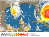
STORM STATUS September 25, 10:57 AM EDT
Name: Hurricane Jeanne
Location: just to the west of marsh harbor on the abaco island or about 75 miles, 120 km, east of freeport grand bahama island. This position is also about 155 miles, 250 km, East of The Southeastern Coast Of Florida.
Lat/Long: 26.6N, 77.6W
Max Winds: 115 mph
Category: 3
Heading: West
Speed: 14 mph
Pressure: 28.20 inches
Hurricane Jeanne Update
Hurricane Jeanne Now Cattegory 3, Could Become Category 4 Storm
UPDATED: 11:06 am EDT September 25, 2004
FORT PIERCE, Fla. -- Hurricane Jeanne forced the evacuations of more than 800,000 residents Saturday as it gained speed and bore down on Florida with winds near 115 mph and threatened to strengthen even more before hitting land
If it hits Florida's Atlantic Coast late Saturday or Sunday as predicted, it would be the fourth hurricane to slam the state this season, a scenario unmatched in more than a century. Jeanne hovered off the coast as a Category 3 storm, but Jack Beven, a hurricane specialist at the National Hurricane Center in Miami, warned that a Category 4 storm with winds of at least 131 mph "is not out of the question."
Already blamed for the deaths of at least 1,100 people in Haiti, Jeanne was poised to slam some of the same areas hit by the earlier storms, potentially transforming still-uncleared piles of debris into deadly missiles.
"This is all we have left," Pam Curtis said Friday, shedding tears as she glanced at a heap of smashed furniture in front of her stripped Fort Pierce condominium. The debris pile left by Hurricane Frances matched her own height. "When this other hurricane comes, this pile is going to be knocking down the rest of it."
No state has been struck by four hurricanes in one season since Texas in 1886. Since early August, hurricanes have rattled southwest Florida (Charley), the state's midsection (Frances) and Florida's Panhandle (Ivan). Combined, the storms have caused billions of dollars of damage and at least 70 deaths in Florida.
"I know people are frustrated, they're tired of all this," Gov. Jeb Bush said. "Trust me, their governor is as well."
Hurrycane Jeanne Update
Special Local Hurricane Statement
Expires 04:00 PM EDT op 25 september, 2004
Statement as of 7:25 am EDT on September 25, 2004
A Special evacuation advice for coastal east central Florida media outlets please give widest dissemination.
A Hurricane Warning is in effect from Florida City to Saint Augustine which includes all of the east central Florida coast.
Areas affected
This hurricane local statement recommends actions to be taken
by residents of the following counties,
Volusia
Brevard
Indian River
Saint Lucie
Martin.
Watches and warnings
A Hurricane Warning remains in effect from Florida City to Saint Augustine which includes all of the east central Florida coastal counties from Martin to Volusia.
A Hurricane Warning means that hurricane conditions are likely for these locations in the next 24 hours.
The Hurricane Warning includes Lake Okeechobee.
Storm information
At 7 am EDT, the large eye of Hurricane Jeanne was located about 225 miles east of Stuart Florida.
Jeanne is moving toward the west near 14 mph.
The current forecast is for a Florida landfall as a major hurricane around midnight between Palm Beach and Cocoa Beach.
Precautionary/preparedness actions
We are concerned after watching some news accounts regarding residents of barrier islands who are planning to ride out Hurricane Jeanne based on their experiences with Hurricane Frances.
We have done a detailed damage survey of the coastline of the impact of
Hurricane Frances and it is important for residents to realize that the worst wind and storm surge from Frances affected an unpopulated area of Hutchinson Island between Fort Pierce beach and Jensen Beach and Nettles Island.
The greatest impact was from near Middle Cove beach access to herman's Bay Park.
Evidence of battering waves on top of storm surge to a height of 12 feet or
greater along with extreme beach erosion and a bridge failure were noted.
Importantly, people located on the north and south end of Hutchinson Island did not receive the worst of the impacts of Frances.
We also noted that Volusia and northern Brevard County experienced only category one hurricane effects from Frances.
Southern Brevard and Indian River counties experienced category one to category two impacts with Martin and St Lucie counties solidly within the category two impact range.
To base your evacuation decision solely on your personal experiences during Frances is a mistake.
Jeanne will likely be stronger especially near and to the right of where the inner eyewall makes landfall.
At this point it is still uncertain exactly where this area will be. There is plenty of time this morning to commit to evacuating as advised and move to safety.
We have made it through Charley and Frances without any direct deaths from hurricane wind or water impacts, please follow advice of your County officials and lets all make it through this again.
Next update
The next hurricane local statement will be issued around noon today, or sooner if conditions warrant.
NemoRocks78
Seized
Corrus said:Don't get your hopes out Nemo...
The parks will probably close their gates tomorrow at 03:00PM...
Remember, I said probably...
Greetz!
I was expecting something like that, but I am glad to hear that they aren't going to shut down all day. The forecast I just saw on television has it near the area at 8pm Sunday.
I'm already looking into boarding schools over in California (finish high school there).....can anyone suggest any good ones? :lol:
Register on WDWMAGIC. This sidebar will go away, and you'll see fewer ads.