-
The new WDWMAGIC iOS app is here!
Stay up to date with the latest Disney news, photos, and discussions right from your iPhone. The app is free to download and gives you quick access to news articles, forums, photo galleries, park hours, weather and Lightning Lane pricing. Learn More -
Welcome to the WDWMAGIC.COM Forums!
Please take a look around, and feel free to sign up and join the community.
You are using an out of date browser. It may not display this or other websites correctly.
You should upgrade or use an alternative browser.
You should upgrade or use an alternative browser.
The Official Hurricane Jeanne thread
- Thread starter Tim G
- Start date
WDWScottieBoy
Well-Known Member
Do you have any more tracks for it Corrus or radar imaegs of where it is right now?
I'm hoping everyone is safe right now. Miss M, hope you don't see any damage at your place if it does head directly to you. Rob and Dave, hope your apartment isn't shaking as much anymore. Everyone else, I'm thinking about you!
I'm hoping everyone is safe right now. Miss M, hope you don't see any damage at your place if it does head directly to you. Rob and Dave, hope your apartment isn't shaking as much anymore. Everyone else, I'm thinking about you!
PhotoDave219
Well-Known Member
We need a wet/dry vac. Or kitty litter. LOTS of kitty litter.
Figment1986
Well-Known Member
few pics... (just north of Tampa)
Here are some of my photos taken about 30min to 54min ago...


(downsized to get themup faster.. DSL went out.... Looks great when they are wallpapered....) :lookaroun
Here are some of my photos taken about 30min to 54min ago...
(downsized to get themup faster.. DSL went out.... Looks great when they are wallpapered....) :lookaroun
Mary Poppins
Member
Figment1986 said:This is the first time FLA got hit by 3 major Hurricains within a short time period... The location where it has came on, first time in about 100 years it got his by such a storm i heard by my local fox affieliate...
(earlier i said storms... which counts Tropical storms through hurricains.. meaning anything that had been named and hit FLA..)
Florida was hit by three storms in 1964.
WDWScottieBoy
Well-Known Member
PhotoDave219 said:We need a wet/dry vac. Or kitty litter. LOTS of kitty litter.
I have a wet/dry vac and would gladly let you use it, but the problem is, I'm still stuck here in northern IL and you're in FL. Even through this storm, I still wish I lived there right now. Can you tell us what it's like out there right now Dave or anyone else that's on and lives in the area. If you go outside for photos, STAY SAFE!
Scott
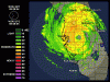
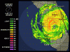
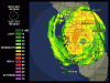
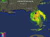
Hurricane Jeanne Update
STORM STATUS September 26, 10:38 AM EDT
Name: Hurricane Jeanne
Location: About 30 Miles East-Southeast of Tampa Florida.
Lat/Long: 27.9N, 82.0W
Max Winds: 75 mph
Category: 1
Heading: West-Northwest
Speed: 10 mph
Pressure: 28.64 inches
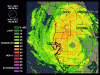
STORM STATUS September 26, 10:38 AM EDT
Name: Hurricane Jeanne
Location: About 30 Miles East-Southeast of Tampa Florida.
Lat/Long: 27.9N, 82.0W
Max Winds: 75 mph
Category: 1
Heading: West-Northwest
Speed: 10 mph
Pressure: 28.64 inches
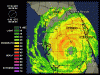
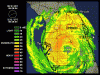
Hurricane Jeanne Advisory Number 52
Issued at: 10:38 AM EDT 9/26/04
Jeanne nearing the tampa bay area
A hurricane warning remains in effect along the west coast of florida from englewood to the suwannee river.
At 11 am edt, 1500z, the hurricane warning from north of deerfield beach to jupiter inlet Florida is discontinued. A hurricane warning remains in effect for the Florida east coast from north of jupiter inlet to st. Augustine, including lake okeechobee.
A tropical storm warning remains in effect along the Florida gulf coast south of englewood to chokoloskee, and north and west of the suwannee river to destin.
At 11 am edt, 1500z, the hurricane watch from north of st. Augustine Florida to altamaha sound georgia is discontinued. A tropical storm warning remains in effect from north of st. Augustine Florida northward to the savannah river.
At 11 am edt, 1500z, the center of hurricane jeanne was located near latitude 27.9 north, longitude 82.0 west or about 30 miles east-southeast of tampa Florida.
Jeanne is moving toward the west-northwest near 10 mph. A gradual turn toward the northwest is expected during the next 24 hours. This motion should bring the center of jeanne near the tampa bay area in a few hours, and near or just offshore of the Florida west coast to the north of tampa bay later today.
Maximum sustained winds are near 75 mph, with higher gusts. Jeanne is expected to weaken below hurricane strength later today.
Hurricane force winds extend outward up to 70 miles from the center, and tropical storm force winds extend outward up to 175 miles. Winds have continued to increase in the tampa bay area. A wind gust to 67 mph was reported at vandenburg airport near tampa, and a gust to 60 mph was reported at sarasota.
Estimated minimum central pressure is 970 mb, 28.64 inches.
Coastal storm surge flooding, along with large and dangerous battering waves, will gradually subside along the Florida east coast. A storm surge of up to 5 feet above the present water level is likely to occur mainly on the east side of lake okeechobee.
Tides of 2 to 4 feet above normal are possible in the warned area along the Florida west coast, and higher at the heads of bays. Tides could possibly reach 3 to 6 feet in areas of onshore flow north of tampa bay.
Rainfall totals of 5 to 10 inches, with isolated higher amounts are possible near the path of jeanne.
Isolated tornadoes are possible over portions of the central and northern Florida peninsula and southeastern georgia today.
Repeating the 11 am edt position, 27.9 n, 82.0 w. Movement toward, west-northwest near 10 mph. Maximum sustained winds, 75 mph. Minimum central pressure, 970 mb.
For storm information specific to your area, please monitor products issued by your local weather office.
An intermediate advisory will be issued by the national hurricane center at 2 pm edt followed by the next complete advisory at 5 pm edt.
Hurricane Jeanne Update
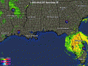
Hurricane Jeanne Leaves Over 1.5 Million Without Power
UPDATED: 11:51 am EDT September 26, 2004
STUART, Fla. -- Hurricane Jeanne blasted ashore in Florida with drenching rains and 120 mph wind, tearing off rooftops, hurling debris through the air and sending huge waves crashing into buildings before weakening as it sliced across the central part of the state.
At least 1.5 million people were without power.
The Category 3 storm became the fourth hurricane to pummel Florida in a single season, something that has not happened since 1886 when Texas was the target.
The three other hurricanes -- Charley, Frances and Ivan -- have all hit within the last six weeks.
Debris left from the other storms became airborne as Jeanne made landfall shortly before midnight near the southern tip of Hutchinson Island near Stuart, about 35 miles north of West Palm Beach.
The same area was ravaged by Frances just three weeks ago.
At the Ocean Breeze trailer park in Jensen Beach, roofs of mobile homes were peeled back like the lids of sardine cans.
Computer printers, hair dryers and propane canisters littered the road. Metal sidings clanged in the wind.
Rain whipped sideways in sheets, sections of road were washed out by pounding waves and at least a foot of water rushed through some streets in Vero Beach.
"The last three weeks have been horrific and just when we start to turn the corner, this happens," said Joe Stawara, owner-manager of Fairlane Harbor Mobile Home Estates, where half of the 232 trailers were damaged.
The 400-mile diameter storm then swirled north into central Florida, an area saturated by rain from previous hurricanes that caused billions of dollars in damage and killed at least 70 people.
One person was electrocuted in Miami early Sunday after touching a downed power line, and minor injuries were reported.
Bridges from the mainland to Hutchinson Island were flooded and impassable early Sunday. On the barrier island, water rushed through the bottom floor of Atlantis condominiums, where John Lumberson and son Josh rode out the storm. The parking lot was buried in 5 feet of sand and water, and sand rose to kitchen cabinets inside first floor condos.
"It sounded like the whole building was coming down," said Josh Lumberson. "You could hear every metal screw coming out of the walls."
Register on WDWMAGIC. This sidebar will go away, and you'll see fewer ads.