11 counties are now under advisories,
watches, or severe weather warnings.
Southern Lake County
Severe Weather Bulletin:
Issued at: 11:18 AM EDT 9/24/04, expires at: 5:00 AM EDT 9/25/04
Inland hurricane wind watch Saturday night and Sunday for okeechobee, osceola, orange, seminole and lake counties,
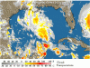
Hurricane jeanne is forecast to move west across the northern bahamas Saturday. The hurricane is forecast to strengthen to a borderline category three hurricane as it approaches the coast and begins a northwest turn late Saturday night and Sunday morning near or along the east central Florida coast.
The latest track from the national hurricane center brings hurricane force winds, 75 mph or greater, into okeechobee and osceola counties very late Saturday night or early Sunday morning. Hurricane force winds are then expected very near or across orange, seminole, and lake counties, including orlando, sanford and leesburg Sunday.
There still is uncertainly in the exact track of hurricane jeanne, which could shift the strongest winds farther east or west, however preparations should begin now for significant wind impacts from hurricane jeanne. Once confidence in the track increases, the inland hurricane wind watch will be upgraded to a warning, possibly later today.
If you live in a mobile home, or a home that affords little protection from flying glass and debris, plan to move to an alternative refuge in a sturdy building or residence for this weekend.
Move any loose outdoor items that can be carried away by the wind indoors. Loose items can become airborne, resulting in additional damage and possible injuries.
Trees and branches weakened by recent hurricanes are susceptible to falling during the storm.
Damage to shingles, siding, and pool screens may also occur to permanent homes. Large branches can snap, with water logged trees becoming uprooted and falling on structures.
Hurricane force winds can also blow temporary tarps loose from roofs which can allow water damage to your home.
Take necessary precautions today to prepare for hurricane jeanne.
This bulletin affects: Northern Lake, Okeechobee, Orange, Osceola, Seminole, Southern Lake, including the cities of Clermont, Kissimmee, St. Cloud, Leesburg, Orlando, Sanford
watches, or severe weather warnings.
Southern Lake County
Severe Weather Bulletin:
Issued at: 11:18 AM EDT 9/24/04, expires at: 5:00 AM EDT 9/25/04
Inland hurricane wind watch Saturday night and Sunday for okeechobee, osceola, orange, seminole and lake counties,
Hurricane jeanne is forecast to move west across the northern bahamas Saturday. The hurricane is forecast to strengthen to a borderline category three hurricane as it approaches the coast and begins a northwest turn late Saturday night and Sunday morning near or along the east central Florida coast.
The latest track from the national hurricane center brings hurricane force winds, 75 mph or greater, into okeechobee and osceola counties very late Saturday night or early Sunday morning. Hurricane force winds are then expected very near or across orange, seminole, and lake counties, including orlando, sanford and leesburg Sunday.
There still is uncertainly in the exact track of hurricane jeanne, which could shift the strongest winds farther east or west, however preparations should begin now for significant wind impacts from hurricane jeanne. Once confidence in the track increases, the inland hurricane wind watch will be upgraded to a warning, possibly later today.
If you live in a mobile home, or a home that affords little protection from flying glass and debris, plan to move to an alternative refuge in a sturdy building or residence for this weekend.
Move any loose outdoor items that can be carried away by the wind indoors. Loose items can become airborne, resulting in additional damage and possible injuries.
Trees and branches weakened by recent hurricanes are susceptible to falling during the storm.
Damage to shingles, siding, and pool screens may also occur to permanent homes. Large branches can snap, with water logged trees becoming uprooted and falling on structures.
Hurricane force winds can also blow temporary tarps loose from roofs which can allow water damage to your home.
Take necessary precautions today to prepare for hurricane jeanne.
This bulletin affects: Northern Lake, Okeechobee, Orange, Osceola, Seminole, Southern Lake, including the cities of Clermont, Kissimmee, St. Cloud, Leesburg, Orlando, Sanford


 )
)