The Official Hurricane Jeanne thread

rctfan

New Member
:mad: :mad: :mad: a few days ago, my travel agency told me that the hotel I was supposed to go was closed because of damages caused by Charley. They relocated me in another hotel nearby.
And now, I just discover on American Airlines website that my flight between Chicago and Orlando is cancelled ! (I was supposed to leave Brussel tomorrow, and arrive at Orlando at 7pm). I guess it's because MCO will probably close on Sunday. Do you think it will re-open on monday ?
 

Tim G

Well-Known Member
Original Poster
Hurricane Jeanne Update

State braces for onslaught
East coast likely will feel wind, rain this afternoon

September 25, 2004, 4:59 AM EDT

MIAMI -- Resigned and frustrated Floridians braced Friday for Hurricane Jeanne, which forecasters said should strengthen and start pounding the state's east coast with whipping wind and rain late this afternoon.

Ports were closing, and shelters were opening. Sandbags were ready, and curfews set. Hotels filled up, and emergency-response trucks rolled.
The anxiety mounted Friday as nearly 1 million coastal residents and mobile-home dwellers from Miami-Dade to Flagler counties were ordered to begin evacuating today to avoid the fourth hurricane to torment the Sunshine State in six weeks.

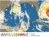
At 5 a.m. today, Jeanne was a Category 2 storm with winds of about 105 mph. It was moving westward at 14 mph and was located about 240 miles east of the southeastern coast of Florida. Hurricane-force winds extend outward up to 70 miles, and tropical-storm-force winds extend outward up to 205 miles.

In New Smyrna Beach, Marilee Walters sat on the sidewalk in front of her Flagler Avenue shop, the Sanctuary, and watched in disbelief as friends covered her windows with plywood.

"We're exhausted, and we're just hoping we can get through this one," Walters said. "At this point, I think we're all pretty numb."

In Tallahassee, Gov. Jeb Bush expressed an exasperation shared by the state's 17 million residents.
"Sometimes it feels like this is a test of resiliency for our state," the governor said. "Other times I feel like I'm Bill Murray in Groundhog Day. But we're going to get through this."

Orange County Chairman Rich Crotty marveled at what nature is throwing Florida's way.
"This is a weather freak show," Crotty said. "We've never dealt with a situation like this."
On Friday night, hurricane warnings covered nearly all of Florida's east coast as Jeanne barreled westward.

Forecasters are confident that Jeanne, which was expected to strengthen before landfall from a Category 2 storm to a Category 3 with at least 111-mph winds, will make a gradual curve northward. But Friday, they couldn't answer the critical question: When?
"This is just too close to call," Max Mayfield, director of the National Hurricane Center, said Friday night. "This is not going to be an easy one."

Just how much -- and where -- Jeanne will affect the state depended on a ridge of high pressure hovering over the mid-Atlantic, which for three days has kept the storm on a beeline for the state's coast. Computer models forecast the ridge to erode sometime today, and if it does, Jeanne could be pulled more northward.

If that happens and occurs early enough, the storm might stay offshore, coming close enough to pummel the state with wind, rain and surf, but keeping its most vicious east side at sea. That would be the best scenario for Florida, but not Georgia or the Carolinas.

"It could turn just before the coast, if we're lucky," said Ed Rappaport, the hurricane center's deputy director. "But if we're lucky, someone else isn't."
If Jeanne follows the official forecast track set Friday, the storm would plow into the coastline early Sunday near St. Lucie County, not far from where Hurricane Frances struck Sept. 5.

Then it would grind its way north in a shallow arc to the Georgia-Florida border. Under that scenario, the east coast of Central Florida would begin feeling tropical-storm-force winds of at least 39 mph by this evening. The storm was expected to produce hurricane-force winds of 74 mph or higher about 70 miles from its center and tropical-storm-force winds up to 205 miles from its core.

By early Sunday, the winds would increase, sweeping the eye across Brevard, Orange, Seminole, Volusia and Flagler counties. The pounding could last all day.
Forecasters predicted rainfall totals of 5 to 10 inches, prompting concerns about already swollen lakes, rivers and streams.

State emergency officials, who already have dealt with Hurricanes Charley, Frances and Ivan in the past few weeks, said they're ready. They began rushing shipments of ice, water, food and generators to supply depots along the east coast.
"I've been asked a lot of times, 'Are we up for another hurricane?' " said Craig Fugate, director of Florida's Division of Emergency Management. "We're tired, but there is another storm threatening our state, and we're ready to go."

More than readiness, resignation prevailed in Central Florida, which is still recovering from double punches by Frances and Charley. As Gail Gregory, director of the Mental Health Association of Volusia County said, "We're all starting to show fine-line cracks along the way."

To cope, she recommended spending time with family, limiting exposure to hurricane news and taking advantage of hot water and electricity -- while they last. Gregory also said to avoid alcohol.
"There's nothing a drink won't make worse," she said.

In Brevard County, where officials banned the sale of alcohol and imposed curfews tonight and Sunday night, motorists began lining up for gas before daybreak Friday at an Exxon station in Cocoa.
"This is insane," said Donnie Hair, as he waited behind at least half a dozen cars. By 3 p.m., the station's manager, Peter Schmidt, was out in the parking lot walking from car to car.
"You might be wasting your time," he told drivers. "I'm down to my last 100 gallons and probably won't get any more today."

In Titusville, Robert Lord pulled up his truck to a service station to top off the tank before heading home to put on his last two sheets of plywood.
"It's getting to us," he said. "The last one was enough, but this is just over the limit."

Kennedy Space Center was closed to all but essential employees Friday. The National Aeronautics and Space Administration facility suffered the worst damage in its history from Frances. A team designated to ride out the storm on the site will emerge as soon as Jeanne passes to assess any further damage.

At the Super Target store at the Mall at Millenia in Orlando, customers trickled in to buy water, toiletries and canned goods. But the frenzy that came ahead of Frances and Charley, which hammered Charlotte County on Aug. 13 before pummeling Central Florida, was absent.
"I think that because a lot of people have already stocked up from previous hurricanes," said Millie Douglas, a store manager, "the traffic is not as bad."

And in St. Augustine, Bill Cushion, a horse-carriage driver, vented about lost revenue. "No one comes out," he said. "I've had my fill of storms. I had my fill of them after the first one went through."
No one shared that sentiment more than the forecasters at the hurricane center, who were at a loss to explain why Florida has been in the cross hairs all season.
"It just seems Florida has that 'Kick Me' sign on it," Mayfield said.
 

Tim G

Well-Known Member
Original Poster
Hurricane Jeanne Update

Gulf Coast I.R. Satellite

Image Delay = 30 Mins.
 

Attachments

  • Jeanne_ir_loop_04.gif
    Jeanne_ir_loop_04.gif
    538.8 KB · Views: 113

Tim G

Well-Known Member
Original Poster
Hurricane Jeanne Update

Jeanne Continues March Toward Florida
Hurricane Watch Posted Along Coast

UPDATED: 5:13 am EDT September 25, 2004


Hurricane Jeanne is packing 105 mph winds and becoming better organized Saturday as it heads toward Florida and the northern Bahamas.

Jeanne is now centered at latitude 26.5 north, longitude 76.2 west or 240 miles east of the Florida coastline.
Movement is to the west at 14 mph, with top sustained winds still at about 105 mph, making it a powerful Category 2 hurricane. With plenty of warm ocean waters between the storm and the Flroida coast, forecasters said there could be some slow strengthening.

There's a hurricane warning flying along the Florida east coast from Florida City northward to St. Augustine, including Lake Okeechobee.

The big question remains just when Jeanne is going to begin its expected turn to the northwest and then north.
The center of the official forecast map shows landfall south of Cape Canaveral early Sunday morning, though the wider forecast cone covers an area from South Carolina southward to about the Miami area.

Hurricane force winds extend outward up to 70 miles and tropical storm-force winds out from center up to 205 miles.
Jeanne will cover a much larger area than just the landfall target. Forecast models vary, with some showing the northward turn before actual landfall. But others show a track across the Florida peninsula before the turn occurs.

With that in mind, the official track shows a turn to the north as Jeanne's center makes landfall, then going up Florida's east coast to the Jacksonville area by Monday morning.
 

Tim G

Well-Known Member
Original Poster
Jews Celebrating Holiest Day Of Year Must Make Choice


Jewish Floridians trying to prepare for oncoming Hurricane Jeanne face a dilemma. Saturday is Yom Kippur, the holiest day on the Jewish calendar, when Jews are prohibited from carrying money or doing any physical tasks that may be required for hurricane preparations.

So what will they do? Some said preparing for the hurricane takes precedence over holiday norms, so they'll do what's required to protect themselves and their families.

Others said they planned to finish their preparations before the holiday began at sundown Friday, while still others said they don't think the storm will be that serious.

With about 750,000 Jews, Florida has one of the nation's largest Jewish populations. Many live in the area within the area Jeanne could target.
 

Tim G

Well-Known Member
Original Poster
STORM STATUS September 25, 4:37 AM EDT

Name: Hurricane Jeanne
Location: About 55 miles, 90 km, east of great abaco island in the northwestern bahamas.
This position is also about 240 miles, 385 km, East of The Southeastern Coast Of Florida.

Lat/Long: 26.5N, 76.2W
Max Winds: 105 mph
Category: 2
Heading: West
Speed: 14 mph
Pressure: 28.29 inches
 

Tim G

Well-Known Member
Original Poster
Hurricane Jeanne Update

Thousands Urged To Evacuate As Jeanne Nears Florida

UPDATED: 1:09 am EDT September 25, 2004


FORT PIERCE, Fla. -- About three-quarters of a million residents of Florida's east coast were urged to evacuate -- again -- as Hurricane Jeanne churned westward Friday and threatened the state with its fourth pounding in six weeks.

The 100-mph storm could come ashore somewhere on the state's east coast by Sunday, targeting some of the same areas hit by previous storms and potentially turning piles of still-uncleared debris into deadly missiles.

"I'm not staying in this bunch of junk," 76-year-old Ed Oglesby said as he patched his torn roof in a Hutchinson Island mobile home park still littered with twisted metal and insulation from homes wrecked by Hurricane Frances.

A single state hasn't been hit by four hurricanes in a single season since Texas in 1886. Jeanne could continue a devastating run that has thrashed Florida's Panhandle (Ivan), southwest coast (Charley) and the state's midsection (Frances). Together, they have caused billions of dollars of damage and at least 70 deaths in the state.
"I know people are frustrated, they're tired of all this," Gov. Jeb Bush said. "Trust me, their governor is as well."

Crews with bulldozers worked Friday to clear the mess of flattened homes, torn roofs and snapped trees left over when Frances tore through the heart of the state earlier this month. But many acknowledged it was a losing battle.
"With another hurricane, there's just too much there -- we just don't have the manpower to get it all done," said Martin County spokesman Greg Sowell, who estimated nearly 80 percent of debris remained from Frances. He said some streets had debris piled 5 feet to 6 feet high.

Pam Custis shed tears Friday as she looked at a heap of smashed furniture and flooded carpets in front of her Fort Pierce condominium, which has been stripped to a skeleton of concrete floors and metal frames. The debris pile was as tall as she is.
"This is all we have left," she said of her condo's shell. "When this other hurricane comes, this pile is going to be knocking down the rest of it."

Eight counties along about 300 miles of coastline issued evacuation orders for residents on barrier islands, low-lying areas and mobile homes. That includes more than 750,000 people.
But with almost the entire state in Jeanne's danger zone and a hurricane warning stretching from Miami-Dade County in the south to St. Augustine in the north, some questioned whether there was any safe place to run.

"I ain't going anywhere unless they make me," retiree Larry Ruby said as he patched the roof of his Hutchinson Island mobile home. "I don't think you can get away from it."
Jeanne, already blamed for at least 1,100 flooding deaths in Haiti, looked earlier this week like it had turned north and safely out to sea, but it whipped around in a loop and headed straight for Florida.

At 11 p.m., Jeanne was centered about 315 miles east of the southeast Florida coast and moving west at 12 mph. Forecasters said it could strengthen as it reaches warmer waters closer to Florida's coast.

An eventual turn to the northwest was predicted, but it was unclear when that would happen, and some models show the storm strafing the East Coast all the way up to North Carolina by Tuesday.
Rainfall totals of 5 to 10 inches were expected in the storm's path and flooding could be a major concern because previous hurricanes have already saturated many canals, rivers and lakes.

The timing of the storm raised concern for Jews observing Yom Kippur. The holiest day on the Jewish calendar begins at sundown Friday and ends sundown Saturday. During that period, observant Jews usually do not work or carry cash and many do not travel by car, all of which could hamper their hurricane preparations.

The National Hurricane Center advisory even asked people to consider that Jewish neighbors may not be listening to radios or watching television and may be unaware of the situation.
"I don't know if I will evacuate or not," physician Armand Braun said as he stocked up supplies at a grocery store in Satellite Beach. "Jewish law says you put Jewish requirements aside if there is any danger."
Taking nothing for granted, residents up and down Florida's Atlantic coast went about what has become an all-too-familiar ritual.

In Broward County, lines of cars spilled onto streets outside gas stations as people, remembering gas shortages from Frances, filled up their tanks. Kennedy Space Center, still trying to repair damage to a massive assembly building caused by Frances, was ordered closed Friday to all nonessential personnel.
Three other tropical systems were spinning Friday, but none of them threatened Florida.
 

Tim G

Well-Known Member
Original Poster
Hurricane Jeanne Advisory Number 47

Issued at: 4:37 AM EDT 9/25/04

Jeanne moving westward toward the abaco islands, expected to intensify into a category three hurricane

A hurricane warning is in effect along the Florida east coast from florida city northward to st. Augustine, including lake okeechobee. A hurricane warning is also in effect for the northwestern bahamas, including the abacos, andros island, berry islands, bimini, eleuthera, grand bahama island, and new providence. Preparations to protect life and property throughout the hurricane warning area should be rushed to completion.

A hurricane watch remains in effect for the northeast Florida and georgia coasts from north of st. Augustine to altamaha sound georgia.

At 5 am edt, 0900z, a tropical storm warning is in effect along the west coast of Florida from east cape sable northward to anclote key. A tropical storm warning remains in effect for the central bahamas, including cat island, the exumas, long island, rum cay, and san salvador.

At 5 am edt, 0900z, the tropical storm watch has been extended northward along the west coast of Florida to the ochlockonee river. A tropical storm watch is now in effect from south of Florida city around the southern end of the Florida peninsula to east cape sable, and north of anclote key along the west coast to the ochlockonee river, including Florida bay, and the Florida keys north of the seven mile bridge.
We are reminded that yom kippur, a solemn jewish holiday, will last until sundown today. Some of your jewish neighbors in the watch and warning areas observing yom kippur will not be listening to radios or watching tv, and may not be aware of the hurricane situation.

At 5 am edt, 0900z, the center of hurricane jeanne was located near latitude 26.5 north, longitude 76.2 west or about 55 miles, 90 km, east of great abaco island in the northwestern bahamas. This position is also about 240 miles, 385 km, east of the southeastern coast of Florida.

Jeanne is moving toward the west near 14 mph, 22 km/hr, and this motion is expected to continue for the next 24 hours. On this track, the core of jeanne will be passing near or over the abaco islands in the next few hours, near or over the remainder of the northwestern bahamas later today, and approach the southeastern coast of Florida tonight or early Sunday.

Reports from an air force reserve hurricane hunter aircraft indicate that maximum sustained winds are near 105 mph, 165 km/hr, with higher gusts. Strengthening is forecast during the next 24 hours, and jeanne will likely become a major hurricane later today.

Hurricane force winds extend outward up to 70 miles, 110 km, from the center, and tropical storm force winds extend outward up to 205 miles, 335 km.
The latest minimum central pressure reported by the hurricane hunter is 958 mb, 28.29 inches.

Storm surge flooding of 4 to 8 feet above normal tide levels, along with large and dangerous battering waves, can be expected near the center of jeanne on the north side of grand bahama island and on the west side of the abaco islands. Storm surge flooding of 2 to 4 feet above normal tide levels can be expected on the west side of the other islands of the bahamas in the hurricane warning area.

Coastal storm surge flooding of 4 to 6 feet above normal tide levels, along with large and dangerous battering waves, can be expected near and to the north of where the center makes landfall along the Florida east coast.
Tides of 1 to 2 feet above normal are possible in the warned area along the Florida west coast.
Rainfall totals of 5 to 10 inches, with isolated higher amounts, are possible along the track of jeanne over the northwestern bahamas and Florida.

Dangerous surf and rip currents, caused by large swells generated by hurricane jeanne, are possible elsewhere along the southeastern u.s. Coast and the northwest and the bahamas for the next few days.
Repeating the 5 am edt position, 26.5 n, 76.2 w. Movement toward, west near 14 mph. Maximum sustained winds, 105 mph. Minimum central pressure, 958 mb.
For storm information specific to your area, please monitor products issued by your local weather office.

An intermediate advisory will be issued by the national hurricane center at 8 am edt followed by the next complete advisory at 11 am edt.
 

Tim G

Well-Known Member
Original Poster
The National Weather Service has issued a
HURRICANE STATEMENT

06:10 AM EDT Sat-Sep-25

Florida counties
Brevard, Indian River, Lake, Orange, Osceola, Seminole, Volusia

These bulletins are currently in effect for your area:
Florida counties


Alachua
HURRICANE STATEMENT


Brevard
HURRICANE STATEMENT
FLOOD WATCH

Citrus
HURRICANE STATEMENT until 09:00 AM EDT
FLOOD WATCH

Flagler
HURRICANE STATEMENT

Hernando
HURRICANE STATEMENT until 09:00 AM EDT
FLOOD WATCH

Highlands
HURRICANE STATEMENT until 09:00 AM EDT

Hillsborough
HURRICANE STATEMENT until 09:00 AM EDT
FLOOD WATCH
I
ndian River
HURRICANE STATEMENT
FLOOD WATCH

Lake
HURRICANE STATEMENT
FLOOD WATCH

Levy
HURRICANE STATEMENT until 09:00 AM EDT
FLOOD WATCH

Marion
HURRICANE STATEMENT

Orange
HURRICANE STATEMENT
FLOOD WATCH

Osceola
HURRICANE STATEMENT
FLOOD WATCH

Pasco
HURRICANE STATEMENT until 09:00 AM EDT
FLOOD WATCH

Pinellas
HURRICANE STATEMENT until 09:00 AM EDT
FLOOD WATCH

Polk
HURRICANE STATEMENT until 09:00 AM EDT

Putnam
HURRICANE STATEMENT

Seminole
HURRICANE STATEMENT
FLOOD WATCH

St Johns
HURRICANE STATEMENT

Sumter
HURRICANE STATEMENT until 09:00 AM EDT

Volusia
HURRICANE STATEMENT
FLOOD WATCH
 

The Mom

Moderator
Premium Member
JEANNE CHANGED TRACK!!!!

The latest predictions have Jeanne going more westerly, shifting to more southern coastal and inland counties....including the WDW area!

PLEASE NOTE....this changed overnight, so can change again before Jeanne makes landfall!!!

In short, this is good news for me (NE FL) but bad news for others.
 

The Mom

Moderator
Premium Member
rctfan said:
:mad: :mad: :mad: a few days ago, my travel agency told me that the hotel I was supposed to go was closed because of damages caused by Charley. They relocated me in another hotel nearby.
And now, I just discover on American Airlines website that my flight between Chicago and Orlando is cancelled ! (I was supposed to leave Brussel tomorrow, and arrive at Orlando at 7pm). I guess it's because MCO will probably close on Sunday. Do you think it will re-open on monday ?


Maybe, but I wouldn't count on it. ALL schools in Northeast Florida are closed on Monday, and since Jeanne has shifted ( 11PM friday to 5AM saturday showed a significant change), she will have a GREATER impact on Orlando than originally predicted unless she shifts course again, so things will probably be closed in Orlando on Monday, or they'll be backed up trying to complete departing flights that were cancelled Sunday. That's under the assumption that the airport doesn't sustain any major damage.
 

NemoRocks78

Seized
Premium Member
Mr D said:
The hurricane gods are demanding Michael Eisner as a sacrifice :wave:

If he immediately resigns, no more hurricanes this season will strike Florida! :D

:sohappy:

Now they are saying here that this thing has changed its track and is going to make landfall in the same place Frances did. Oh joy. :brick:

And check out this article from the Post today.....I tell you this: Kissimmee Utilities is a thousand times better than FP&L.

Power could be out by 2 p.m. Saturday
By KRISTI E. SWARTZ
Palm Beach Post Staff Writer
Saturday, September 25, 2004


JUNO BEACH — As Hurricane Jeanne bore down on Palm Beach County and the Treasure Coast Saturday, Florida Power & Light Co. customers should be prepared to lose power as early as 2 p.m., officials said.

Area emergency management officials said early Saturday that FP&L had notified them that because Jeanne could pick up in both speed and strength, some wind-weary local residents may lose power early Saturday afternoon, in addition to being out of power as long as three weeks.

Late Friday, FPL spokeswoman Geisha Williams said considering the path Jeanne is expected to follow — at 5 a.m., the National Hurricane Center was predicting landfall somewhere between West Palm Beach and Fort Pierce early Sunday. — and that repairmen have been working "nonstop" since Hurricane Charley hit southwest Florida in August, "the restoration time may take longer than what our customers have already experienced this season.?

What Williams called "perhaps the biggest challenge? to a swifter process is that extra help to fix things could be in short supply. After Hurricane Frances, FPL brought in 7,000 utility workers from outside the state to help restore power to about 5 million people — an effort that took two weeks and pushed local customers' patience to the limit.

But the destruction caused by Hurricane Ivan is tying up utility workers in other states, which will make it more difficult for FPL to get the assistance it needs after Hurricane Jeanne brings a fresh round of destruction to the region.

"We're going to have to go out and compete with everybody else for additional crews," FPL spokesman Bill Swank said late Friday.


I seriously think that they purposely shut off the power. :lol:
 

NemoRocks78

Seized
Premium Member
For all of you coming into MCO this weekend, I have some bad news..... :(

From the Orlando Sentinel:

Orlando International Airport will close Saturday at 5 p.m.
 

Tim G

Well-Known Member
Original Poster
Mr D said:
The hurricane gods are demanding Michael Eisner as a sacrifice

If he immediately resigns, no more hurricanes this season will strike Florida!
IMO a dumb remark, regarding this coming weather...

Maybe it will make some laughter in the Eisner threads... not in here...

So please, leave the so-called Eisner jokes out of the weather forums please, please, please...


Greetz! :D
 

Tim G

Well-Known Member
Original Poster
Hurricane Jeanne Intermediate Advisory Number 47a

Issued at: 7:39 AM EDT 9/25/04

Eye Of Jeanne Very Near Marsh Harbor On Abaco Island

A hurricane warning is in effect along the Florida east coast from florida city northward to st. Augustine, including lake okeechobee. A hurricane warning is also in effect for the northwestern bahamas, including the abacos, andros island, berry islands, bimini, eleuthera, grand bahama island, and new providence. Preparations to protect life and property throughout the hurricane warning area should be rushed to completion.

A hurricane watch remains in effect for the northeast Florida and georgia coasts from north of st. Augustine to altamaha sound georgia.

A tropical storm warning remains in effect along the west coast of florida from east cape sable northward to anclote key. A tropical storm warning remains in effect for the central bahamas, including cat island, the exumas, long island, rum cay, and san salvador.

A tropical storm watch is now in effect from south of Florida city around the southern end of the Florida peninsula to east cape sable, and north of anclote key along the west coast to the ochlockonee river, including Florida bay, and the Florida keys north of the seven mile bridge.

We are reminded that yom kippur, a solemn jewish holiday, will last until sundown today. Some of your jewish neighbors in the watch and warning areas observing yom kippur will not be listening to radios or watching tv, and may not be aware of the hurricane situation.

At 8 am edt, 1200z, the center of hurricane jeanne was located by a reconnaissance plane near latitude 26.5 north, longitude 77.0 west just over marsh harbour, abaco island in the northwestern bahamas. This position is also about 190 miles, 310 km, east of the southeastern coast of Florida.

Jeanne is moving toward the west near 14 mph, 22 km/hr, and this motion is expected to continue for the next 24 hours. On this track, the core of jeanne will be passing near or over the remainder of the northwestern bahamas later today, and approach the southeastern coast of Florida tonight or early Sunday. Hurricane force winds are expected to spread inland across much of the Florida peninsula.

Maximum sustained winds remain near 105 mph, 165 km/hr, with higher gusts. Strengthening is forecast during the next 24 hours, and jeanne will likely become a major hurricane later today.

Hurricane force winds extend outward up to 70 miles, 110 km, from the center, and tropical storm force winds extend outward up to 205 miles, 335 km. Marsh harbor just reported sustained winds of near 46 mph, 74 km/hr and a pressure of near 963 mb, 28.44 inches.

The latest minimum central pressure reported by the hurricane hunter is 957 mb, 28.26 inches.
Storm surge flooding of 4 to 8 feet above normal tide levels, along with large and dangerous battering waves, can be expected near the center of jeanne on the north side of grand bahama island and on the west side of the abaco islands. Storm surge flooding of 2 to 4 feet above normal tide levels can be expected on the west side of the other islands of the bahamas in the hurricane warning area.

Coastal storm surge flooding of 4 to 6 feet above normal tide levels, along with large and dangerous battering waves, can be expected near and to the north of where the center makes landfall along the Florida east coast.
Tides of 1 to 2 feet above normal are possible in the warned area along the Florida west coast.

Rainfall totals of 5 to 10 inches, with isolated higher amounts are possible along the track of jeanne over the northwestern bahamas and Florida.
Dangerous surf and rip currents, caused by large swells generated by hurricane jeanne, are possible elsewhere along the southeastern u.s. Coast and the northwest and the bahamas for the next few days.

Repeating the 8 am edt position, 26.5 n, 77.0 w. Movement toward, west near 14 mph. Maximum sustained winds, 105 mph. Minimum central pressure, 957 mb.
For storm information specific to your area, please monitor products issued by your local weather office.

The next advisory will be issued by the national hurricane center at 11 am edt.
 

Tim G

Well-Known Member
Original Poster
STORM STATUS September 25, 7:39 AM EDT

Name: Hurricane Jeanne
Location: just over marsh harbour, abaco island in the northwestern bahamas. This position is also about 190 miles, 310 km, East of The Southeastern Coast Of Florida.

Lat/Long: 26.5N, 77.0W
Max Winds: 105 mph
Category: 2
Heading: West
Speed: 14 mph
Pressure: 28.26 inches
 

Tim G

Well-Known Member
Original Poster
Hurricane Jeanne Update

Jeanne Expected To Become Category 3

Hurricane Warning For Florida, Bahamas

UPDATED: 9:24 AM EDT September 25, 2004


MIAMI -- Forecasters are now expecting Hurricane Jeanne to strengthen to a Category 3 storm.

They say Jeanne will likely become a major hurricane over the next 24 hours.

A hurricane warning is in effect for Florida's east coast -- stretching 300 miles from Miami Dade County all the way to St. Augustine -- and the northwestern Bahamas. A tropical storm warning has been issued along the west coast of Florida.
The path of Hurricane Jeanne is uncertain because the storm is expected to make a turn to the north just about the time the center strikes the shoreline. Forecasters say regardless of where it hits, much of Florida will be affected.

At 5 a.m. EDT Saturday, Jeanne was centered about 240 miles east of the Palm Beach area and was moving west at 14 mph, slightly faster than Friday. Sustained winds were 105 mph, up from 100 mph late Friday.

Some 800,000 Floridians have been urged to evacuate, but some say they won't go unless they're forced to. Gov. Jeb Bush says he realizes people are frustrated by the hurricanes. In his words, "Trust me, their governor is as well."
Florida work crews are bracing for Jeanne as they continue to clean up from this season's string of killer storms.
For the fourth time this season, Floridians are dashing to the store to buy food, water and plywood and work crews are rushing to do as much trash pickup as possible, to keep storm leftovers from turning into wind-born missiles if Jeanne stays on track.

National Hurricane Center Director Max Mayfield said the last time a state was hit by four hurricanes in a single year was Texas, in 1886.
He said he knows Floridians might feel fatigued by Charlie, Frances, and Ivan, but he said there's no choice but to deal with Jeanne.
The state is restocking centers in Homestead, Lakeland and Jacksonville to be ready to respond after Jeanne. Officials said gasoline supplies have also been replenished at terminals.
With hotels full of relief workers and some shelters damaged from earlier storms, Gov. Bush said people should plan early.

The hurricane center is reminding people that starting at sundown Friday night through sundown Saturday is the Jewish holiday Yom Kippur. Forecasters said Jews observing the holiday won't be listening to radios or watching television and may not be aware of the hurricane situation.

Meanwhile, the Kennedy Space Center director has ordered the base closed to all non-essential personnel. NASA's spaceport is still trying to repair damage caused by Frances and Charley.
Four college football games set for Florida this weekend were either postponed or had their start times moved because of Jeanne.

Florida moved its Southeastern Conference game against Kentucky in Gainesville to 11:30 a.m. Saturday; Florida Atlantic canceled its home opener with Illinois State in Fort Lauderdale; Florida International's home opener with Western Kentucky was postponed and in Daytona Beach, Bethune-Cookman moved up its kickoff time three hours to 10 a.m. Saturday.
A decision on Sunday's Pittsburgh at Miami NFL game could come late Saturday.
 

speck76

Well-Known Member
NemoRocks78 said:
For all of you coming into MCO this weekend, I have some bad news..... :(

From the Orlando Sentinel:

Orlando International Airport will close Saturday at 5 p.m.


Yeah....I am stuck in Michigan, my flight back to Orlando tomorrow night was cancelled, and it looks like the Orlando Airport will reopen at noon on Monday at the earliest.

SO

I switched my flight for tomorrow night into Tampa, and reserved a car to drive back to Orlando.


*praying for Tampa Airport to stay open*
 

Atta83

Well-Known Member
speck76 said:
Yeah....I am stuck in Michigan, my flight back to Orlando tomorrow night was cancelled, and it looks like the Orlando Airport will reopen at noon on Monday at the earliest.

SO

I switched my flight for tomorrow night into Tampa, and reserved a car to drive back to Orlando.


*praying for Tampa Airport to stay open*

Good luck!!!!
 

Wilt Dasney

Well-Known Member
I was sent out this morning to get "man on the street" reaction for our Jeanne story today. We're just close enough to Florida that we've had to worry about all of these things, but so far, no more than some downed limbs and minor flooding from Frances.
 

Register on WDWMAGIC. This sidebar will go away, and you'll see fewer ads.

Back
Top Bottom