The Official Hurricane Jeanne thread

WDWScottieBoy

Well-Known Member
Nicholas, I'd head down Saturday. I mean come on, who wouldn't want to be at WDW extra days? If you're going to be down there during a hurricane, might as well spend it in WDW and get there before any delays may come. Just stay safe and enjoy your trip, don't let any hurricanes get to you!
 

919Florida

Well-Known Member
I just read the following on the Orlando Sentinel website:

Florida faces its fifth tropical system of the season with Hurricane Jeanne, whose latest projected path has it missing Central Florida, but hitting east coast Sunday morning.
 

Tim G

Well-Known Member
Original Poster
Hurricane Jeanne Update

Floridians On Alert As Hurricane Jeanne Nears State

UPDATED: 12:18 pm EDT September 24, 2004


WEST PALM BEACH, Fla. -- Hurricane Jeanne trekked westward Friday on a path that could lead to Florida's east coast by Sunday, setting off another round of storm preparations in a state still reeling from three earlier strikes.

The fears of more flooding, devastation and power outages sent many people scurrying to local grocery and hardware stores, stocking up on supplies that quickly ran low before the last storms. State and federal officials geared up for another disaster response.

"I know people are frustrated, they're tired of all this," Gov. Jeb Bush said Friday. "Trust me, their governor is as well."

"Our resources are stretched, but we remain committed in our mission to serve the state's 17 million residents in preparing and responding to all of these storms," Bush said.

Jeanne could slam into Florida just over a week after Hurricane Ivan thrashed the Panhandle Sept. 16. Ivan and the two previous storms, Charley and Frances, caused billions of dollars of damage and were blamed for at least 70 deaths in the state.

A hurricane watch was issued at 5 a.m. EDT Friday from Florida City near the state's southern tip to St. Augustine. The watch for most of the state's east coast means hurricane conditions with winds of at least 74 mph are possible within 36 hours.

At 11 a.m., Jeanne was centered about 485 miles east of Miami and moving west at 9 mph, and was expected to reach Florida by Sunday, according to the National Hurricane Center in Miami. It had top sustained winds of 100 mph, but could strengthen as it reaches warmer waters closer to Florida's coast. Hurricane force winds extend out 45 miles from the center and tropical storm winds extend out 140 miles.


Residents of Gonaives, Haiti make their way between houses on flooded streets in the aftermath of Tropical Storm Jeanne Thursday Sept. 23, 2004. More than 1,100 people were killed and 1,250 are missing, and the toll is rising. The storm left 300,000 homeless in Haiti's northwest province, which includes the port of Gonaives.

An eventual turn to the northwest was predicted, but it was unclear if that would happen before Jeanne reached Florida. Computer models showed possible landfall anywhere from South Florida to Cape Canaveral.

Because the storm was forecast to be so close to Florida, the state is "going to have impacts no matter what," said Lt. Dave Roberts, a meteorologist at the hurricane center.

The only other time four hurricanes hit the same state in one season was in Texas in 1886, National Hurricane Center Director Max Mayfield said.

Scientists say Atlantic and Gulf Coast states may be entering a period of heavy storm activity after a relatively quiet phase. Florida has been spared in recent years and landfall statistics are likely to balance out over time, Mayfield said.

"We've just reached some level of normalcy and here it comes again. I've never seen anything like this," said Margaret McFarlane, of Greenacres. "We've already refilled our refrigerators, gotten the debris out of the streets and it's going to happen all over again. I'm not sure how much more people can take."

Work crews along the state's Atlantic Coast worked Friday to remove debris left behind from Hurricane Frances, which struck Sept. 4-5. But many acknowledged it was a losing battle.

"With another hurricane, there's just too much there -- we just don't have the manpower to get it all done," said Martin County spokesman Greg Sowell, who estimated nearly 80 percent of debris remained from Frances. He said some streets had "debris piled up 5 to 6 feet high."

Bush recommended Friday that members of the Jewish faith should take into account that the storm could threaten the state during Yom Kippur. The holiest day on the Jewish calendar begins at sundown Friday and ends sundown Saturday. During that period, observant Jews usually don't work or carry cash and many don't travel by car, all of which could hamper their hurricane preparations.

"We ask those who are keeping their faith and their strict Orthodox practices to prepare early," Bush said.

Though it wasn't clear exactly where the storm would hit, Kennedy Space Center director James Kennedy ordered the base closed to all nonessential personnel Friday.

NASA's spaceport is still trying to repair damage caused by Frances. Gaping holes remain in the massive Vehicle Assembly Building, where space shuttles are attached to their booster rockets and external fuel tanks before launch.

Other disruptions included the postponement of Florida International University's home opener against Western Kentucky when that school determined it was better for its athletes not to travel to South Florida this weekend.

The Miami Dolphins and Pittsburgh Steelers are considering moving up their game a day to Saturday. The Steelers will fly to South Florida on Friday, one day ahead of their typical travel schedule.

Jeanne was blamed for more than 1,100 deaths in Haiti, where it hit over the weekend as a tropical storm and caused major flooding. Because parts of Florida are already waterlogged, flooding could be a major problem again.

The previous hurricanes have saturated many canals, rivers and lakes. In Seminole County, the swollen St. Johns River is receding but Jeanne's rains could raise the waters again. Currently, there's moderate flooding on a 30-mile stretch but no serious damage has been reported.

"It's just going to be another waiting game," Sanford fire inspector Mark James said. "You can't predict how much is going it's going to do."
 

Tim G

Well-Known Member
Original Poster
Hurricane Jeanne Advisory Number 44

Issued at: 10:41 AM EDT 9/24/04

Jeanne Continues Its Westward Trek Toward The Northern Bahamas


A hurricane warning is in effect for the northwestern bahamas including the abacos, andros island, berry islands, bimini, eleuthera, grand bahama island, and new providence. A hurricane warning means that hurricane conditions are expected in the warning area within the next 24 hours.

A hurricane watch is in effect along the east coast of Florida from florida city to st. Augustine. A hurricane watch means that hurricane conditions are possible in the watch area in the next 36 hours.

A tropical storm warning is in effect for the central bahamas, including cat island, the exumas, long island, rum cay, and san salvador. A tropical storm warning means that tropical storm conditions are expected in the warning area in the next 24 hours.

Interests elsewhere on the Florida peninsula should closely monitor the progress of jeanne.

We are reminded that from sundown tonight until sundown Saturday is yom kippur, a solemn jewish holiday. Some of your jewish neighbors in the watch and warning areas observing yom kippur will not be listening to radios or watching tv, and may not be aware of the hurricane situation.

At 11 am edt, 1500z, the center of hurricane jeanne was located near latitude 26.2 north, longitude 72.4 west or about 290 miles, 470 km, east of great abaco island.

Jeanne is moving toward the west near 9 mph, 15 km/hr, and this motion is expected to continue with a slight increase in forward speed during the next 24 hours. This motion could bring the center of jeanne near the northwestern bahamas on Saturday.

Maximum sustained winds are near 100 mph, 160 km/hr, with higher gusts. Some slow strengthening is possible during the next 24 hours.

Hurricane force winds extend outward up to 45 miles, 75 km, from the center, and tropical storm force winds extend outward up to 150 miles, 240 km.

The estimated minimum central pressure is 969 mb, 28.61 inches.

Rainfall totals of 5 to 10 inches are possible along the track of jeanne.

Tides will gradually be rising in the warned area during the next 24 hours. Additionally, dangerous surf and rip currents, caused by large swells generated by hurricane jeanne, are possible elsewhere along the southeastern u.s. Coast and the northwest and central bahamas for the next few days.

Repeating the 11 am edt position, 26.2 n, 72.4 w. Movement toward, west near 9 mph. Maximum sustained winds, 100 mph. Minimum central pressure, 969 mb.

For storm information specific to your area, please monitor products issued by your local weather office.

An intermediate advisory will be issued by the national hurricane center at 2 pm edt followed by the next complete advisory at 5 pm edt.
 

Tim G

Well-Known Member
Original Poster
Update Hurricane Jeanne

Atlantic I.R. Satellite

Image Delay = 30 Mins.
 

Attachments

  • Jeanne_ir_loop_02.gif
    Jeanne_ir_loop_02.gif
    520.8 KB · Views: 124

Tim G

Well-Known Member
Original Poster
Hurricane Jeanne Update

STORM STATUS September 24, 1:39 PM EDT

Name: Hurricane Jeanne
Location: About 255 miles, 415 km, East of Great Abaco Island.
Lat/Long: 26.3N, 72.9W
Max Winds: 100 mph
Category: 2
Heading: West
Speed: 12 mph
Pressure: 28.61 inches

Close-Up Projected Path Through Central Florida
 

Attachments

  • 3758177.jpg
    3758177.jpg
    27.7 KB · Views: 113

Tim G

Well-Known Member
Original Poster
Hurricane Jeanne Update

Weary Floridians prepare for another onslaught

September 24, 2004


TALLAHASSEE -- Storm weary state emergency planners today said they have begun rushing shipments of ice, water, food and generators to supply depots on the east coast in preparation for Hurricane Jeanne.

"I've been asked a lot of times, are we up for another hurricane?" said Craig Fugate, director of Florida's division of emergency management. "There are no quitters on the state emergency response team. We're tired but there is another storm threatening our state and we're ready to go."

A hurricane watch was issued at 5 a.m. EDT today from Florida City near the state's southern tip to St. Augustine. The watch for most of the state's east coast means hurricane conditions with winds of at least 74 mph are possible within 36 hours.

At 11 a.m., Jeanne was centered about 485 miles east of Miami and moving west at 9 mph, and was expected to reach Florida by Sunday, according to the National Hurricane Center in Miami. It had top sustained winds of 100 mph, but could strengthen as it reaches warmer waters closer to Florida's coast. Hurricane force winds extend out 45 miles from the center and tropical storm winds extend out 140 miles.

An eventual turn to the northwest was predicted, but it was unclear if that would happen before Jeanne reached Florida. Computer models showed possible landfall anywhere from South Florida to Cape Canaveral.

Because the storm was forecast to be so close to Florida, the state is "going to have impacts no matter what," said Lt. Dave Roberts, a meteorologist at the hurricane center.

The only other time four hurricanes hit the same state in one season was in Texas in 1886, National Hurricane Center Director Max Mayfield said.

Scientists say Atlantic and Gulf Coast states may be entering a period of heavy storm activity after a relatively quiet phase. Florida has been spared in recent years and landfall statistics are likely to balance out over time, Mayfield said.

As Florida prepares for its fourth major storm in six weeks, emergency response trucks are already rolling to restock supply depots in south, central and north Florida – at Homestead, Lakeland and Jacksonville – because no one is yet sure exactly where the storm will hit.

"I know people are frustrated. They're tired of this. Believe me, their governor is as well," said Gov. Jeb Bush. "Sometimes it feels like this is a test of resiliency for our state. Other times I feel like I'm Bill Murray in Ground Hog Day. But we're going to get through this."

The push to move supplies into Homestead is a lesson learned from Hurricane Frances when emergency responders had a hard time getting through traffic on Interstate 95 to get supplies to hard hit areas like Palm Beach County.

"We learned that I-95 is a very long road," Fugate said. "We're building up resources until the storm comes through and then we'll start again. If we need to, we'll fly supplies into Homestead."

Although smaller than Hurricanes Ivan and Frances, Hurricane Jeanne is expected to pack a wallop for areas in its path. State officials said the storm would bring heavy rain, a 7 to 10-foot storm surge and high winds. It could impact a wide swath of the state, depending on the final track it takes.

"A good portion of the east coast could be impacted," said state meteorologist Ben Nelson, predicting potential damage over hundreds of miles, especially if the storm rakes the coastline as it moves north.
 

nicholas

New Member
We just got off the phone with JetBlue. We're coming a day early (tomorrow morning) in order to dodge any airport closings, and tacking on a day at the end of the trip to make up for any park closures we might run into. Now I just have NO time to get ready! Eeep!
 

Tim G

Well-Known Member
Original Poster
Hurricane Jeanne Update

Jeanne Picks Up Speed, Moves Toward Florida


Hurricane Watch Posted Along Coast

UPDATED: 2:00 pm EDT September 24, 2004

Hurricane Jeanne is picking up speed as it heads toward Florida and the northern Bahamas Friday, maintaining strength as it goes.

Jeanne is now centered at latitude 26.3 north, longitude 72.9 west or 255 miles east of Great Abaco Island.
Movement is to the west at 12 mph, with top sustained winds still at about 100 mph.
Forecasters said there could be some slow strengthening.

There's a hurricane warning flying in the northwestern Bahamas, with a hurricane watch posted along most of Florida's Atlantic coast.
The watch runs from Florida City northward to St. Augustine.

The big question remains just when Jeanne is going to begin its expected turn to the northwest and then north.
The center of the official forecast map shows landfall south of Cape Canaveral early Sunday morning, though the wider forecast cone covers an area from South Carolina southward to about the Miami area.

With tropical storm-force winds out from center up to 150 miles, Jeanne will cover a much larger area than just the landfall target.
Forecast models vary, with some showing the northward turn before actual landfall, but others show a track across the Florida peninsula before the turn occurs.

With that in mind, the official track shows a turn to the north as Jeanne's center makes landfall, then going up Florida's east coast to the Jacksonville area by Monday morning.
 

Tim G

Well-Known Member
Original Poster
Hurricane Jeanne Update

New Path Brings Jeanne Inland


The storm's projected path as of 11 a.m. would bring the hurricane ashore as a Category 2 storm near southern Brevard County before it turns more northward and passes over Volusia, Flagler, St. Johns and Duval counties.

The National Weather service has issued inland hurricane wind watches for Lake, Orange, Osceola and Seminole counties through Sunday.
 

Tim G

Well-Known Member
Original Poster
Hurricane Jeanne Update

Gov. Bush Urges Residents To Prepare


During a news conference in Tallahassee Friday, Gov. Jeb Bush asked residents, especially those along the Atlantic coastline and barrier islands, to begin preparing for the storm.

Bush said he's worried that many of those who have come away unscathed by the previous hurricanes may not take the watch seriously.

"I know people are frustrated.
I know they're tired of this, trust me their governor is tired too, but we should heed the warnings of the experts as it relates to evacuating.
It's not being done in a flippant fashion if they do occur," Bush said.

Folks in Florida are just plain tired of hurricanes, but Jeanne is looming this weekend.

Yet again, the fear of more flooding, devastation and power outages has sent many people scurrying to local grocery and hardware stores, stocking up on supplies that quickly ran low before the last storms.
State and federal officials are again gearing up for another disaster response.

If there's a bright spot, the over-and-over hurricane status has meant many people already have their hurricane supplies.
But even those who don't live in the Jeanne-threatened area have long since before tired of being on constant watch.

The National Hurricane Center said the only other time four hurricanes hit the same state in one season was in 1886, in Texas.
Scientists said Atlantic and Gulf Coast states may be entering a period of heavy storm activity after a relatively quiet phase.

Jeanne is blamed for more than 1,100 deaths in Haiti, where it hit over the weekend as a tropical storm and caused major flooding.
Because parts of Florida are already waterlogged, flooding could be a major problem again.
 

Tim G

Well-Known Member
Original Poster
Hurricane Jeanne Update

Bahamas Brace For Jeanne


For fear of damage on top of damage, people in the Bahamas are strapping plastic sheeting over the holes in their roofs.

A rain-making Hurricane Jeanne is stalking the same communities struck by Frances -- and could bring battering winds to the island chain Sunday.
One building contractor who's helping patch up earlier storm damage said he'll "just pray for safekeeping."

Jeanne has already killed more than 1,100 people in Haiti, and threatens to blow toward storm-weary Florida.
After looping around the Atlantic for days, Jeanne is now steering 100 mph winds toward the capital of the Bahamas -- Nassau -- and the second-biggest city, Freeport.

Like Floridians, Bahamians are still trying to recover from a vicious hurricane season. Frances killed two people, damaged thousands of homes, and left tens of thousands in the dark when it tore through the Bahamas three weeks ago.
 

Tim G

Well-Known Member
Original Poster
Constant Hurricanes Wreck Tourism


The constant flow of hurricanes through Florida this year is doing a real number on the state's No. 1 industry.
Back-to-back-to-back hurricanes have pummeled expensive oceanfront resorts in Florida, eroding sandy beaches and damaging some hotels.

It will take months for some to recover, and this week's threat of Hurricane Jeanne is not helping.

There are also the repeated images of boarded up homes, flooded streets and fallen trees on television.
Put it all together and Florida's tourism industry has a major problem.

The economic effect of the hurricanes on the state's tourism has yet to be calculated.
But it could be in the billions of dollars, since a one percent loss in annual market share for the state equals a loss of $5.4 billion in tourism-related spending.

Tourism is the state's largest industry, accounting for almost one-tenth of Florida's $500 billion economy.

In one ominous sign, hotel occupancy rates in two of Florida's largest markets, Miami and Tampa, were down 22 percent last week compared to the same time last year.
 

Tim G

Well-Known Member
Original Poster
11 counties are now under advisories,
watches, or severe weather warnings.

Alachua County


Flood Warning:

Issued at: 11:06 AM EDT 9/24/04, expires at: 11:06 AM EDT 9/25/04


A river flood warning continues for the santa fe at fort white. three rivers estates, hildreth on u.s. 129 bridge,
For the santa fe river at fort white, moderate flooding is occurring, with a stage of 26.4 feet measured at 10 am Friday. At 26.0 feet, damage to homes at low elevation as well as basement areas underneath homes on stilts is likely.
For the santa fe river at three rivers estates, moderate flooding is occurring, with a stage of 21.2 feet measured at 8 am Friday. The river is forecast to begin a slow fall over the next few days and reach 21 feet on Wednesday September 29th. At 21.2 feet, north part of the santa fe road is closed.
For the santa fe river at hildreth on u.s. 129 bridge, the latest stage was 20.6 feet at 7 am Friday. No flooding is forecasted.
Do not drive vehicles through flooded areas. Turn around, don''t drown. Listen to noaa weather radio for the latest developments
 

Tim G

Well-Known Member
Original Poster
11 counties are now under advisories,
watches, or severe weather warnings.

Northern Brevard County


Hurricane Bulletin:

Issued at: 12:55 PM EDT 9/24/04, expires at: 6:00 PM EDT 9/24/04

Storm weary floridians are reminded that hurricane jeanne has the potential to become a category three storm by landfall,
Precautionary/preparedness actions. east central Florida has been subjected to repeated batterings from hurricanes charley and frances. Many residents have suffered damage ranging from minor to extreme. Many homes are still in disrepair, and some properties remain under water.
This is a reminder from your national weather service, that you cannot afford to take this situation any less seriously than with previous storms. Also keep in mind that each one of the effects from jeanne, wind, rain, and storm surge, will be magnified due to the effects of the previous hurricanes of the past 6 weeks. Weakened structures will be even more vulnerable to being damaged or destroyed by these effects.
Hurricane frances produced effects ranging from category one to the lower end of category two. Jeanne has the potential to strengthen into a category three hurricane prior to landfall, meaning conditions could be even more destructive near the center, than what occurred with frances.
Take the needed steps to protect yourself, your loved ones, and your property. Those thinking of riding jeanne out in homes near the coast, or those dwellings incapable of being subjected to hurricane force winds and torrential rain, should strongly reconsider evacuating to a safer location when the order is given.
 

Tim G

Well-Known Member
Original Poster
11 counties are now under advisories,
watches, or severe weather warnings.

Southern Brevard County


Hurricane Bulletin:

Issued at: 12:55 PM EDT 9/24/04, expires at: 6:00 PM EDT 9/24/04

Storm weary floridians are reminded that hurricane jeanne has the potential to become a category three storm by landfall,
Precautionary/preparedness actions. east central Florida has been subjected to repeated batterings from hurricanes charley and frances. Many residents have suffered damage ranging from minor to extreme. Many homes are still in disrepair, and some properties remain under water.
This is a reminder from your national weather service, that you cannot afford to take this situation any less seriously than with previous storms. Also keep in mind that each one of the effects from jeanne, wind, rain, and storm surge, will be magnified due to the effects of the previous hurricanes of the past 6 weeks. Weakened structures will be even more vulnerable to being damaged or destroyed by these effects.
Hurricane frances produced effects ranging from category one to the lower end of category two. Jeanne has the potential to strengthen into a category three hurricane prior to landfall, meaning conditions could be even more destructive near the center, than what occurred with frances.
Take the needed steps to protect yourself, your loved ones, and your property. Those thinking of riding jeanne out in homes near the coast, or those dwellings incapable of being subjected to hurricane force winds and torrential rain, should strongly reconsider evacuating to a safer location when the order is given.
 

Tim G

Well-Known Member
Original Poster
11 counties are now under advisories,
watches, or severe weather warnings.

Flagler County

Hurricane Bulletin:

Issued at: 11:34 AM EDT 9/24/04, expires at: 6:00 PM EDT 9/24/04

Hurricane jeanne continues westward toward Florida.
Areas affected. the content of this hurricane local statement recommends actions to be taken by residents in the following counties, in northeast florida, nassau, duval, st. Johns and flagler.
Watches/warnings. a hurricane watch is in effect from st Augustine southward.
Storm information.
At 11 am edt, 1500z, the center of hurricane jeanne was located near latitude 26.2 north, longitude 72.4 west or about 290 miles, 470 km, east of great abaco island.
Jeanne is moving toward the west near 9 mph, 15 km/hr, and this motion is expected to continue with a slight increase in forward speed during the next 24 hours. Maximum sustained winds are near 100 mph, 160 km/hr, with higher gusts. Some slow strengthening is possible during the next 24 hours.
Given the forecast track, interests along the rest of the northeast Florida coast should be alert as watches may need to be extended farther northward later today or tonight. Weather conditions could start to deteriorate in the watch area as early as saturday as jeanne approaches the east coast of Florida. All impacts are highly dependent on the eventual track and intensity of jeanne.
Precautionary/preparedness actions. review your familys hurricane plan and hurricane kit. Marine interests in normally flood prone areas may wish to secure property which could flood.
Storm surge flood and storm tide impacts. at this time, no significant tidal flooding is expected through saturday. By Saturday night, tides of 2 to 3 feet above the height of normal tides will be possible.
Wind impacts. sustained winds will increase to the 25 to 35 mph in the watch area by late Saturday with gusts to 40 to 45 mph possible. These winds are expected to increase Saturday night.
Seas and rip currents. a high risk of rip currents will continue into today. Small craft should stay in port. High surf will continue in the 6 to 8 foot range today and gradually increase through Saturday. Heavy surf and beach erosion will continue to worsen on Saturday.
Flood impacts. hurricane jeanne will pose a threat of heavy rainfall as it moves northwest on Saturday night and Sunday. Areas along the path could see rainfall amounts of 5 to 10 inches.
Next update. the next local statement from the national weather service in jacksonville will be issued around 530 pm edt, or earlier should conditions warrant.
 

Tim G

Well-Known Member
Original Poster
11 counties are now under advisories,
watches, or severe weather warnings.

Northern Lake County

Hurricane Bulletin, Severe Weather Bulletin, Severe Weather Bulletin


Hurricane Bulletin:

Issued at: 12:55 PM EDT 9/24/04, expires at: 6:00 PM EDT 9/24/04

Storm weary floridians are reminded that hurricane jeanne has the potential to become a category three storm by landfall,
Precautionary/preparedness actions. east central Florida has been subjected to repeated batterings from hurricanes charley and frances. Many residents have suffered damage ranging from minor to extreme. Many homes are still in disrepair, and some properties remain under water.
This is a reminder from your national weather service, that you cannot afford to take this situation any less seriously than with previous storms. Also keep in mind that each one of the effects from jeanne, wind, rain, and storm surge, will be magnified due to the effects of the previous hurricanes of the past 6 weeks. Weakened structures will be even more vulnerable to being damaged or destroyed by these effects.
Hurricane frances produced effects ranging from category one to the lower end of category two. Jeanne has the potential to strengthen into a category three hurricane prior to landfall, meaning conditions could be even more destructive near the center, than what occurred with frances.
Take the needed steps to protect yourself, your loved ones, and your property. Those thinking of riding jeanne out in homes near the coast, or those dwellings incapable of being subjected to hurricane force winds and torrential rain, should strongly reconsider evacuating to a safer location when the order is given.


Severe Weather Bulletin:

Issued at: 11:58 AM EDT 9/24/04, expires at: 11:18 AM EDT 9/25/04

For the st. Johns river, including near deland, above lake harney, near sanford, minor to moderate flooding is occuring and is expected to continue.
These river forecasts do not yet include any rainfall projections associated with hurricane jeanne. If heavy rainfall from jeanne occurs over the st. Johns basin, river levels could respond rapidly and reach levels substantially above these current forecasts, followed by longer period rises due to runoff, with levels remaining above flood stage for an extended duration. ***
For the st. Johns river near deland, minor flooding is occuring, with a stage of 4.6 feet measured at 10 am Friday. Minor flooding is forecasted to continue, with a maximum stage of 4.6 feet remaining through Wednesday, which is 0.4 feet above flood stage.
For the st. Johns river above lake harney, minor flooding is occuring, with a stage of 8.9 feet measured at 10 am Friday. Moderate flooding is forecast to occur with the maximum stage reaching 9.1 feet on Tuesday. This is 0.6 feet above flood stage.
For the st. Johns river near sanford, moderate flooding is occuring, with a stage of 6.6 feet measured at 11 am Friday. Moderate flooding is forecast to continue with the maximum stage reaching 6.7 feet on Sunday. This is 0.9 feet above flood stage.
Do not drive cars through flooded areas, persons along the st johns river should take measures to protect life and property from flooding. Do not drive cars through flooded areas. If rising water is observed, move to higher ground immediately.
Never allow children to play in flood waters and do not venture into flood waters by foot. There are dangers in the waters from creatures such as snakes, alligators and leeches. Contamination from raw sewage in the water and the possibility of electrocution from downed power lines!
Interests along the st johns river should closely monitor the latest forecasts and statements.
The latest stage information on the st johns river can be accessed from the national weather service in melbourne website at: at www.weather.gov and then click on east central Florida. From there, go to the left column under current conditions and select rivers and lakes ahps. Stay tuned to developments by listening to noaa weather radio.


Severe Weather Bulletin:

Issued at: 11:18 AM EDT 9/24/04, expires at: 5:00 AM EDT 9/25/04

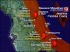
Inland hurricane wind watch Saturday night and Sunday for okeechobee, osceola, orange, seminole and lake counties,
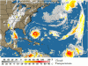
Hurricane jeanne is forecast to move west across the northern bahamas Saturday. The hurricane is forecast to strengthen to a borderline category three hurricane as it approaches the coast and begins a northwest turn late Saturday night and Sunday morning near or along the east central Florida coast.
The latest track from the national hurricane center brings hurricane force winds, 75 mph or greater, into okeechobee and osceola counties very late Saturday night or early Sunday morning. Hurricane force winds are then expected very near or across orange, seminole, and lake counties, including orlando, sanford and leesburg Sunday.
There still is uncertainly in the exact track of hurricane jeanne, which could shift the strongest winds farther east or west, however preparations should begin now for significant wind impacts from hurricane jeanne. Once confidence in the track increases, the inland hurricane wind watch will be upgraded to a warning, possibly later today.
If you live in a mobile home, or a home that affords little protection from flying glass and debris, plan to move to an alternative refuge in a sturdy building or residence for this weekend.
Move any loose outdoor items that can be carried away by the wind indoors. Loose items can become airborne, resulting in additional damage and possible injuries.
Trees and branches weakened by recent hurricanes are susceptible to falling during the storm.
Damage to shingles, siding, and pool screens may also occur to permanent homes. Large branches can snap, with water logged trees becoming uprooted and falling on structures.
Hurricane force winds can also blow temporary tarps loose from roofs which can allow water damage to your home.
Take necessary precautions today to prepare for hurricane jeanne.

This bulletin affects: Northern Lake, Okeechobee, Orange, Osceola, Seminole, Southern Lake, including the cities of Clermont, Kissimmee, St. Cloud, Leesburg, Orlando, Sanford
 

Register on WDWMAGIC. This sidebar will go away, and you'll see fewer ads.

Back
Top Bottom