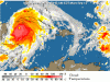
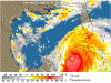
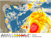
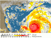
<TABLE borderColor=#000000 cellSpacing=0 cellPadding=2 width="98%" border=1><TBODY><TR><TD bgColor=#ff0000><TABLE width="100%"><TBODY><TR><TD class=large>STORM STATUS</TD><TD class=small align=right>September 13, 1:38 PM EDT</TD></TR></TBODY></TABLE></TD></TR><TR><TD bgColor=#cccccc><TABLE cellSpacing=0 cellPadding=2 width="95%" border=0><TBODY><TR><TD colSpan=2>Name: Hurricane Ivan</TD></TR><TR><TD class=small vAlign=top>Location: About 70 miles, 110 km, South-Southeast of The Western Tip Of Cuba.
Lat/Long: 20.9N, 84.7W
Max Winds: 160 mph
Category: 5
</TD><TD class=small vAlign=top noWrap>Heading: Northwest
Speed: 8 mph
Pressure: 26.99 inches</TD></TR></TBODY></TABLE></TD></TR></TBODY></TABLE>Panhandle residents battening down as Ivan takes aim
September 13, 2004, 3:54 PM EDT
ST. MARKS, Fla. -- Residents of the Florida Panhandle got serious about boarding up windows, stocking food and worrying today as deadly Hurricane Ivan appeared to be heading in their direction as a "very formidable" hurricane.
At the other end of the state, people who had fled the Florida Keys were told the 120-mile island chain had dodged the storm's bullet and the 79,000 residents could go back home.
Emergency officials in several Panhandle counties were expected to decide Tuesday whether to order evacuations from rural fishing villages and beach communities as Ivan threatened to become the third hurricane to hit the state this summer.
"It's stupid to stay unless you like camping in a disaster area.
There's no reason to be out here," retired dental laboratory owner Mark Sigler said today at his house across the street from the Gulf of Mexico on Pensacola Beach.
Forecasters said Ivan, which strengthened back to a Category 5 storm Sunday night with wind up to 160 mph, could strike somewhere along a huge swath of the Gulf Coast by Wednesday after striking Cuba later today.
They advised residents of the Gulf Coast from west-central Florida to the Louisiana marshes to be leery of the storm that already had killed at least 68 people and injured hundreds in the Caribbean.
"I'm not going to stay and wait and see if it's scary," Molly Dupont, 23, said today in Orange Beach, Ala., as she got ready to head for a sister's home in Ohio.
Traffic along the Alabama shore was congested in both directions today. While many were fleeing the beach, workers making storm preparations and people checking on second homes and boats were heading to Gulf Shores.
Some had already started packing during the weekend. "I think it's going to take the trailer. I'm packing up as much as I can," Virginia Gross said Sunday near Fowl River, Ala.
Farther west along the Gulf Coast at Pascagoula, Miss., people were buying hurricane supplies including bottled water, batteries and canned goods, said Randy Howze, manager of a Winn-Dixie supermarket.
"Right now, it's pretty hectic," Howze said this morning.
Before striking the coast, Ivan could be weakened by the cooler water of the northern Gulf of Mexico and wind shear, said National Hurricane Center meteorologist Michael Formosa.
However, that does not mean people should relax, his boss said.
"It's still going to be a very formidable hurricane when it gets into the northeastern Gulf of Mexico," hurricane center director Max Mayfield said today. "It's going to hit somebody there. This is a very, very dangerous hurricane."
While Gulf coast residents were on alert, people in the tourist haven of the Keys and populous South Florida relaxed because Ivan's westward-shifting track meant they were no longer the hurricane's prime target.
Monroe County officials lifted mandatory evacuation orders that began Thursday for tourists.
At 2 p.m. EDT, Ivan was centered 70 miles south-southeast of the western tip of Cuba, and was headed toward the northwest at about 8 mph, a general motion it was expected to continue through midday Tuesday, the Miami-based hurricane center said.
Hurricane warnings were posted for both western Cuba and the tip of Mexico's Yucatan Peninsula.
Ivan still had top sustained wind near 160 mph, up from 150 mph on Sunday. The minimum sustained wind speed for Category 5 status is 156 mph.
Among oil companies with operations in the region, Shell Oil said it would finish evacuating all of its personnel from platforms in the eastern Gulf of Mexico by the end of today and planned to evacuate central gulf operations by Wednesday.
State and federal officials and disaster relief crews who already have dealt with Hurricanes Frances and Charley were preparing for Ivan. Federal Emergency Management Agency head Michael Brown said federal aid is in place to help with recovery from the storm.
Officials in the Keys estimated Ivan would cost $16 million to $20 million in tourism-related sales on top of $35 million lost to Charley last month.
Total insured losses from Charley were estimated at just under $7 billion, and those from Frances were pegged at $2 billion to $4 billion. Experts say overall damages are usually double the insured amount. At least 50 people died in Florida because of those storms.
About 283,000 homes and businesses still had no electricity today as a result of Frances, which plowed ashore on Florida's East Coast on Sept. 5.