-
The new WDWMAGIC iOS app is here!
Stay up to date with the latest Disney news, photos, and discussions right from your iPhone. The app is free to download and gives you quick access to news articles, forums, photo galleries, park hours, weather and Lightning Lane pricing. Learn More -
Welcome to the WDWMAGIC.COM Forums!
Please take a look around, and feel free to sign up and join the community.
You are using an out of date browser. It may not display this or other websites correctly.
You should upgrade or use an alternative browser.
You should upgrade or use an alternative browser.
The Official Hurricane Ivan thread...
- Thread starter FamilyMan
- Start date
Tim G
Well-Known Member
Don't they have a Mandatory Evac overthere ????Maria said:I spoke to a friend in Isla Mujeres -island in front of Cancun- who owns a hotel. Three of their guests decided to stay! Nuts! She is freaking out cause now she has them to worry about too... She said the tides are increasing a lot and it´s pouring already.
Maria
New Member
I am not sure how mandatory it is now, but judging from what she said, it should have been mandatory already.
We still are on yellow alert, meaning that people have to be aware... the coast has started to get evacuated here, but I don´t know more. I can only imagine how Cancun must be... thank God it´s not high season, but still... that´s tons of tourists in so many hotels! (think Miami beach)
We still are on yellow alert, meaning that people have to be aware... the coast has started to get evacuated here, but I don´t know more. I can only imagine how Cancun must be... thank God it´s not high season, but still... that´s tons of tourists in so many hotels! (think Miami beach)
Maria
New Member
Thank God, I live in the capital city of the State, which is 30 kims from the coast and the construction is of blocks of cement/concrete/bricks/stone but the less fortunate´s homes are not that strong, so I fear for them.Corrus said:I understand...
Stay safe, if they tell you to evacuate, do so... there still enough time to do so...
BUT........ Don't wait until the last minute...
Two years ago when Isidore parked on top of us, we saw all kinds of things pass by our door. Luckily, none of them hit the cars or the house, but we lost power for a week and the damages were impressive. We are hoping this one loses strength....

Tim G
Well-Known Member
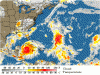
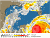
<TABLE borderColor=#000000 cellSpacing=0 cellPadding=2 width="98%" border=1><TBODY><TR><TD bgColor=#ff0000><TABLE width="100%"><TBODY><TR><TD class=large>STORM STATUS</TD><TD class=small align=right>September 12, 7:45 PM EDT</TD></TR></TBODY></TABLE></TD></TR><TR><TD bgColor=#cccccc><TABLE cellSpacing=0 cellPadding=2 width="95%" border=0><TBODY><TR><TD colSpan=2>Name: Hurricane Ivan</TD></TR><TR><TD class=small vAlign=top>Location: About 210 miles, 340 km, Southeast of The Western Tip Of Cuba.
Lat/Long: 19.5N, 82.8W
Max Winds: 150 mph
Category: 4
</TD><TD class=small vAlign=top noWrap>Heading: West-Northwest
Speed: 10 mph
Pressure: 27.02 inches
</TD></TR></TBODY></TABLE></TD></TR></TBODY></TABLE>Hurricane Ivan Intermediate Advisory Number 42a
Issued at: 7:45 PM EDT 9/12/04
Extremely Dangerous Hurricane Ivan Heading For Western Cuba
A hurricane warning remains in effect for the cayman islands.
A hurricane warning is in effect for cuba from pinar del rio to ciego de avila including the isle of youth. A hurricane warning means that hurricane conditions are expected within the warning area within the next 24 hours. Preparations to protect life and property should be rushed to completion.
A hurricane watch remains in effect for the rest of cuba.
A hurricane watch and a tropical storm warning remain in effect for the northeastern yucatan peninsula from tulum to progreso, including cozumel. A hurricane watch means that hurricane conditions are possible within the watch area, generally within 36 hours.
A tropical storm watch remains in effect for the Florida keys from the seven mile bridge westward to the dry tortugas.
Interests in the northwestern caribbean sea, as well as in the central and eastern gulf of mexico, should closely monitor the progress of this extremely dangerous hurricane.
At 8 pm edt, 0000z, the eye of hurricane ivan was located near latitude 19.5 north, longitude 82.8 west or about 210 miles, 340 km, southeast of the western tip of cuba.
Ivan is moving toward the west-northwest near 10 mph, 17 km/hr, and a turn toward the northwest is expected later tonight or on monday. On this track, the center of the hurricane is expected to pass near or over the western end of cuba Monday afternoon or evening.
Maximum sustained winds are near 150 mph, 240 km/hr, with higher gusts. Ivan is a strong category four hurricane on the saffir-simpson hurricane scale. Some fluctuations in intensity are likely during the next 24 hours and ivan could regain category five intensity.
Hurricane force winds extend outward up to 90 miles, 150 km, from the center, and tropical storm force winds extend outward up to 200 miles, 325 km.
A noaa hurricane hunter aircraft reported a minimum central pressure of 915 mb, 27.02 inches.
Storm surge flooding of 5 to 8 feet above normal tide levels, along with large and dangerous battering waves, can be expected in portions of the cayman islands, depending on the exact track of ivan. Coastal storm surge flooding of 20 to 25 feet, locally higher, above normal tide levels, along with large and dangerous battering waves, can be expected near and to the east of where the center makes landfall in cuba.
Rainfall amounts of 8 to 12 inches, possibly causing life- threatening flash floods and mud slides, can be expected along the path of ivan.
Repeating the 8 pm edt position, 19.5 n, 82.8 w. Movement toward, west-northwest near 10 mph. Maximum sustained winds, 150 mph. Minimum central pressure, 915 mb.
For storm information specific to your area, please monitor products issued by your local weather office.
The next advisory will be issued by the national hurricane center at 11 pm edt.
Tim G
Well-Known Member
Local Hurricane Statement
Statement as of 8:30 PM EDT on September 12, 2004
Expires 03:30 AM EDT op 13 september, 2004
Tropical storm watch remains in effect for the Lower Keys and the Dry Tortugas.
New information since last issuance, updated storm information.
Updated preparedness actions
Areas affected
This statement is specific to the Florida Keys of Monroe County.
Precautionary/preparedness actions
Monroe County schools will be closed Monday.
Monroe County offices will be closed through Tuesday.
County emergency management officials are still maintaining a mandatory evacuation due to the threat of Hurricane Ivan and not recommending re-entry into the Keys until the threat has been minimized.
The Monroe County information hot-line has the latest information.
They may be reached at 1 800 955 5504.
The Key West International Airport remains closed to commercial traffic at this time.
Greyhound bus lines service is still suspended.
For updates and details on Greyhound bus service, call 1 800 231 2222.
Storm information
At 800 PM EDT, the center of Hurricane Ivan was located near latitude 19.5 north, longitude 82.8 west, or about 210 miles southeast of the western tip of Cuba.
This is about 370 miles south of Key West.
Maximum sustained winds are near 150 mph with higher gusts.
This makes Ivan an extremely dangerous category four hurricane on the Saffir-Simpson scale.
Some fluctuations in intensity are likely during the next 24 hours.
Ivan is moving toward the west northwest near 10 mph and a turn toward the northwest is expected later tonight.
The center of Ivan is expected to pass near or over the western end of Cuba Monday afternoon or evening.
Minimum central pressure was estimated at 915 mb or 27.02 inches of Mercury.
Watches and warnings
A tropical storm watch is in effect for the Florida Keys from the Seven Mile Bridge westward to the Dry Tortugas.
A tropical storm watch means that winds of 39 to 73 miles per hour are possible in the watch area generally within 36 hours.
Wind impacts
currently, winds over the Lower Keys and nearshore waters are from the east near 20 miles per hour.
Winds are expected to increase to 25 miles per hour with higher gusts through tomorrow.
By Monday night winds will increase to near 30 miles per hour with tropical
storm force winds possible in the Lower Keys and Dry Tortugas.
Storm surge flood and storm tide impacts
No significant storm surge is expected in the Keys with the passage of Hurricane Ivan.
However, high tides in the Lower Keys could run one to two feet above normal tomorrow and tomorrow night.
The next high tides in Key West Harbor will occur at 1005 PM tonight and 949
am Monday morning.
Probability of hurricane/tropical storm conditions
The probability that Hurricane Ivan will pass within 75 miles of Key West is twelve percent.
Marine impacts
Seas are expected to build to seven to ten feet outside the reef and two to four feet inside the reef by tomorrow evening.
Mariners should monitor forecasts until the Hurricane Ivan threat has passed.
Small craft should remain in port.
Next update
The next statement concerning Hurricane Ivan will be issued around 1130 PM.
TimeTrip
Well-Known Member
Maria said:Two years ago when Isidore parked on top of us, we saw all kinds of things pass by our door. Luckily, none of them hit the cars or the house, but we lost power for a week and the damages were impressive. We are hoping this one loses strength....
I hope so! Stay safe!
Tim G
Well-Known Member
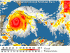
<TABLE borderColor=#000000 cellSpacing=0 cellPadding=2 width="98%" border=1><TBODY><TR><TD bgColor=#ff0000><TABLE width="100%"><TBODY><TR><TD class=large>STORM STATUS</TD><TD class=small align=right>September 13, 1:52 AM EDT</TD></TR></TBODY></TABLE></TD></TR><TR><TD bgColor=#cccccc><TABLE cellSpacing=0 cellPadding=2 width="95%" border=0><TBODY><TR><TD colSpan=2>Name: Hurricane Ivan</TD></TR><TR><TD class=small vAlign=top>Location: About 160 miles, 255 km, Southeast of The Western Tip Of Cuba.
Lat/Long: 19.9N, 83.5W
Max Winds: 160 mph
Category: 5
</TD><TD class=small vAlign=top noWrap>Heading: West-Northwest
Speed: 9 mph
Pressure: 27.17 inches
</TD></TR><TR><TD class=small align=middle colSpan=2></TD></TR></TBODY></TABLE></TD></TR></TBODY></TABLE>Hurricane Ivan Intermediate Advisory Number 43a
Issued at: 1:52 AM EDT 9/13/04
Category Five Hurricane Ivan Threatens Western Cuba
A hurricane warning remains in effect for the cayman islands.
A hurricane warning is in effect for cuba from pinar del rio to ciego de avila including the isle of youth. A hurricane warning means that hurricane conditions are expected within the warning area within the next 24 hours. Preparations to protect life and property should be rushed to completion.
A hurricane watch remains in effect for the rest of cuba.
A hurricane watch and a tropical storm warning remains in effect for the northeastern yucatan peninsula from tulum to progreso. A hurricane watch means that hurricane conditions are possible within the watch area, generally within 36 hours.
A tropical storm watch remains in effect for the Florida keys from the seven mile bridge westward to the dry tortugas.
Interests in the northwestern caribbean sea, as well as in the central and eastern gulf of mexico, should closely monitor the progress of this extremely dangerous hurricane.
At 2 am edt, 0600z, the center of hurricane ivan was located near latitude 19.9 north, longitude 83.5 west or about 160 miles, 255 km, southeast of the western tip of cuba.
Ivan is moving toward the west-northwest near 9 mph, 15 km/hr, and a turn toward the northwest is expected during the next 24 hours. On this track, the center will pass near or over extreme western cuba this evening.
Maximum sustained winds are near 160 mph, 260 km/hr, with higher gusts. Ivan is an extremely dangerous category 5 hurricane on the saffir-simpson hurricane scale. Some fluctuations in intensity are likely during the next 24 hours.
Hurricane force winds extend outward up to 90 miles, 150 km, from the center, and tropical storm force winds extend outward up to 200 miles, 325 km.
An air force reserve unit hurricane hunter aircraft recently reported a minimum central pressure of 920 mb, 27.17 inches.
Coastal storm surge flooding of 20 to 25 feet, locally higher, above normal tide levels, along with large and dangerous battering waves, can be expected near and to the east of where the center makes landfall in western cuba.
Rainfall amounts of 8 to 12 inches, possibly causing life- threatening flash floods and mud slides, can be expected along the path of ivan.
Repeating the 2 am edt position, 19.9 n, 83.5 w. Movement toward, west-northwest near 9 mph. Maximum sustained winds, 160 mph. Minimum central pressure, 920 mb.
For storm information specific to your area, please monitor products issued by your local weather office.
The next advisory will be issued by the national hurricane center at 5 am edt.
Tim G
Well-Known Member
I'm still in California...Maria said:Corrus you are so nice... what are you doing awake?
I´m going to bed now.... see you tomorrow! Thanks!
I'ts 11:57PM overhere... After this post I'm going to sleep...
Kadee
New Member
Every storm prediction track has my area right in the middle. I live on the Alabama Coast (about 20 miles inland from the gulf, but only a couple of miles from the bay). I've ridden out many storms before. I've always lived on the coast (gulf coast and atlantic coast). Been through some big ones (Camile, Fredrick, etc...). But this one really scares me. It is HUGE and very strong. I truely hope is weakens considerably before it hits. My daughter had the best idea: She said, "Let's go to Disney World if the storm hits here!" I think we may at least head that way if the storm hits us or west of us.
pinkrose
Well-Known Member
Kadee said:Every storm prediction track has my area right in the middle. I live on the Alabama Coast (about 20 miles inland from the gulf, but only a couple of miles from the bay). I've ridden out many storms before. I've always lived on the coast (gulf coast and atlantic coast). Been through some big ones (Camile, Fredrick, etc...). But this one really scares me. It is HUGE and very strong. I truely hope is weakens considerably before it hits. My daughter had the best idea: She said, "Let's go to Disney World if the storm hits here!" I think we may at least head that way if the storm hits us or west of us.
I like your daughters idea.
") Since we're further inland, we won't be going anywhere. Come on up to Birmingham (Hoover,actually) if you don't go to Disney. :wave:
Since we're further inland, we won't be going anywhere. Come on up to Birmingham (Hoover,actually) if you don't go to Disney. :wave:PhotoDave219
Well-Known Member
Sorry for you folks in the gulf. The good news is that they expect it to weaken within 48 hours....
Maria
New Member
The rain woke me up at 7:30am. It has stopped now, but we are going to have showers all day.
Cancun is on orange alert now and after 10am they will decide wether to evacuate guests or not and change the alert to red.
What is scary is that Ivan moves veeery slowly... we still don´t know which path is going to take. I have to go work... see you all later!
Cancun is on orange alert now and after 10am they will decide wether to evacuate guests or not and change the alert to red.
What is scary is that Ivan moves veeery slowly... we still don´t know which path is going to take. I have to go work... see you all later!
Register on WDWMAGIC. This sidebar will go away, and you'll see fewer ads.