Gulf Coast preps for Ivan
Associated Press
September 13, 2004, 5:24 PM EDT
Rather than roll the dice on where 160-mph Hurricane Ivan might strike, Gulf Coast residents from Florida's Panhandle all the way to the bayous of Louisiana spent today boarding up their houses, tying up their boats and making plans to evacuate.
"I'm getting the hell out of here. This thing's too big," charter boat captain Jerry Weber said as he steered his 41-foot vessel up the Apalachicola River out of harm's way. "It doesn't matter where it comes ashore, not at this size.
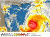
"The hard-to-predict Category 5 storm, one of the most powerful hurricanes ever to hit the Caribbean, killed at least 68 people in a devastating run through Barbados, Grenada, Jamaica and the Cayman Islands.
The storm was headed toward Cuba today.
Emergency officials in several Panhandle counties were expected to decide later today whether to order evacuations for a storm that could strike as early as Wednesday. Already, the military bases in the region flew out some 275 aircraft.
On Pensacola Beach, Mark Sigler and his son stacked sandbags across the driveway of their steel-reinforced dome house that's supposedly designed to withstand hurricane-force winds.
They weren't sticking around to find out.
"It's stupid to stay unless you like camping in a disaster area," he said. "There's no reason to be out here."
At times along its wobbly path, forecasters had predicted Ivan could make direct hits on either the Florida Keys or populous South Florida, only to see it veer west and sidestep both.
Louisiana, Mississippi and Alabama residents had thought they were in the clear, until Ivan shifted over the weekend and put them in the possible path.
"I'm not going to stay and wait and see if it's scary," Molly Dupont said in Orange Beach, Ala., as she got ready to head for a sister's home in Ohio.
Along Mississippi's 75-mile-long coastline, which has been remade in recent years by splashy gambling houses, managers of some floating casinos allowed employees time off in shifts to get their houses secured. But the gambling never stopped.
"It's been business as usual," said Rick Quinn, manager of the Copa Casino in Gulfport. "Of course, we are mindful of the storm."
In the New Orleans area, which is largely below sea level and extremely vulnerable to hurricanes, Lynn Harrington filled her grocery cart with plenty of water, bleach, duct tape, and canned tuna and beans.
"My boyfriend says that if you have cigarettes, toilet paper and lots of booze, you can trade for everything you need," she said.
Theresa Vegas, manager of the Sand Dollar Motel on the barrier island town of Grand Isle, La., said her husband and other shrimpers started bringing in their boats and would decide Tuesday whether to leave.
An evacuation order would make her move faster.
"I'm one of the first ones out of here," she said. "We've gotten stuck here once too often. There's no point in that."
At 5 p.m. EDT, Ivan was centered 30 miles south of the western tip of Cuba, and was headed toward the northwest at near 9 mph.
It had also grown, with hurricane-force winds extending 115 miles from the eye.
Although some forecasters predicted some weakening over the cooler waters of the northeastern gulf, National Hurricane Center director Max Maxfield said Ivan would still be "very formidable" and compared it to Category 4 Hurricane Opal that sent a 15-foot storm surge into the Panhandle in October 1995, killing two people and causing $2 billion damage.
"It's going to hit somebody," he said. "This is a very, very dangerous hurricane."
Florida Gov. Jeb Bush urged residents to heed the warnings.
"This is not the time to be defiant and let people know you are a macho man,' he said. "This is a Category 5 storm. Trust me, this is a powerful force of nature you shouldn't be messing with."
Ivan's run has only added to the anxiety in a state that has already endured Hurricanes Charley and Frances in the past month alone.
Cedar Key, an island in Florida Big Bend area where the peninsula turns into the Panhandle, has either been in the path or in the evacuation zone for the two previous storms and hasn't been ruled out as a target for Ivan.
Many feel that their lives have been on hold for a month.
 . They might leave if the storm comes but who knows. I'm praying for everyone that has been affected and will be affected :wave: :kiss:.
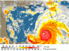
")