-
Welcome to the WDWMAGIC.COM Forums!
Please take a look around, and feel free to sign up and join the community.
You are using an out of date browser. It may not display this or other websites correctly.
You should upgrade or use an alternative browser.
You should upgrade or use an alternative browser.
The Official Hurricane Frances thread...
- Thread starter GoCamels
- Start date
Atta83 said:Talking with Dave right now he said Rob text messaged him and hes fine, but Rob said that this is the worst storm ever.... While Dave say Charley was worse....I'll let you guys decide..
it was actually a joke. A Comic Book guy from the Simpsons reference.
The storm was annoying.
DMC-12
It's HarmonioUS, NOT HarmoniYOU.
ebay6988 said:--------------------------------------------------------------------------------
What the F$#% !!!
Who anon. neg. rep... me here!?!?.... Grrrr...
Some people are soooo rude!!!
So What the hell does this mean???
It means.... Mean people su-diddly-u.c.k ! :wave:
Atta83
Well-Known Member
Whatever.....mkt said:it was actually a joke. A Comic Book guy from the Simpsons reference.
The storm was annoying.

Tim G
Well-Known Member
Someone just kicked me in the face with some negative reputation points...ebay6988 said:--------------------------------------------------------------------------------
What the F$#% !!!
Who anon. neg. rep... me here!?!?.... Grrrr...
Some people are soooo rude!!!
So What the hell does this mean???
It doesn't matter... that person didn't know any better, just a brainless poor entity...
If you need more info PM me... before we go totally off-topic.

mkt said:it was actually a joke. A Comic Book guy from the Simpsons reference.
I love that guy :lol:
Corrus, keep the info coming. :wave: It's much appreciated.
figmentmom
Well-Known Member
mkt said:I'm home. I'm alive and well. I'm searching for a plane ticket to get the hell out of Orlando should Ivan hit.
Any midwestern, west-coast, or Canadian members wanna take me in for a few days?
ANYWHERE but northern New York, huh? (Can't say as I blame you... :lookaroun )
")
Atta83
Well-Known Member
Where in texas.??? :wave:Disnut said:Thanks Corrus. I live in TX and I was really worried about all of you in Flordia. Thanks for keeping me informed and the pics where wonderful.
Tim G
Well-Known Member
Tropical Storm Frances Intermediate Advisory Number 51a
Issued at: 1:30 PM EDT 9/6/04
Frances making landfall near st. Marks Florida,
A hurricane warning remains in effect from the suwanee river to indian pass but will likely be dongraded to tropical storm warning later today.
A tropical storm warning remains in effect from the suwanee river to anna maria island and from indian pass to destin.
Radar and surface observations indicate that at 2 pm edt, 1800z, the center of tropical storm frances was crossing the coast in the vicinity of latitude 30.1 north, longitude 84.1 west, near st. Marks Florida.
Frances is moving toward the north-northwest near 8 mph. On this track, the center of frances should move well inland during the next 12 to 24 hours.
Maximum sustained winds are near 65 mph, with higher gusts. Because frances is moving inland the chances of becoming a hurricane have diminished.
Tropical storm force winds extend outward up to 85 miles from the center.
Estimated minimum central pressure is 980 mb, 28.94 inches.
Storm surge flooding of 2 to 5 feet above normal tide levels is expected south of cedar key. Storm surge flooding of 5 to 10 feet above normal tide levels is expected along the northeast gulf coast of Florida to the north of cedar key, especially to the east of the track. In addition, large and dangerous battering waves can be expected in areas of strong onshore flow.
Rainfall amounts of 6 to 10 inches, with locally higher amounts, are expected over portions of the southeastern united states, especially along and to the east of the path of frances.
Isolated tornadoes are possible today over portions of north and central Florida and the Florida panhandle, and portions of alabama and georgia.
Repeating the 2 pm edt position, 30.1 n, 84.1 w. Movement north-northwest near 8 mph. Maximum sustained winds, 65 mph. Minimum central pressure, 980 mb.
For storm information specific to your area, please monitor products issued by your local weather office.
The next advisory will be issued by the national hurricane center at 5 pm edt.
Atta83
Well-Known Member
Disnut said:south central TX
I am near Galveston.
Corrus said:Someone just kicked me in the face with some negative reputation points...
It doesn't matter... that person didn't know any better, just a brainless poor entity...
If you need more info PM me... before we go totally off-topic.
perhaps it was your endless complaining about double-posting.
just a thought...
Kwit35
New Member
so......anyway, how is everyone doing out there? Here in Tampa, everything has pretty much died down. Everything except the flooding that is. I never made it out of town today. My flight was cancelled and the next available flight was not until wednesday. My poor hubby is getting very lonely up in PA. We are here for two extra days and still never made it to Disney.  The important thing is that everyone is okay, but I can still sulk about Disney...quietly to myself.
The important thing is that everyone is okay, but I can still sulk about Disney...quietly to myself.")
General Grizz
New Member
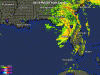
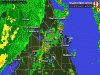
The cave. . . it hurts!!Corrus said:Tropical Storm Frances Update
(Orlando Local Doppler Radar Close-Up )
Image = 10 Mins. Delay
<!-- / message --><!-- attachments -->
Register on WDWMAGIC. This sidebar will go away, and you'll see fewer ads.