-
Welcome to the WDWMAGIC.COM Forums!
Please take a look around, and feel free to sign up and join the community.
You are using an out of date browser. It may not display this or other websites correctly.
You should upgrade or use an alternative browser.
You should upgrade or use an alternative browser.
The Official Hurricane Frances thread...
- Thread starter GoCamels
- Start date
donsullivan
Premium Member
For those of you outside the Orlando area looking for a more immediate and detailed update on the state of the area around Orlando and the storm recovery, ABCNewsNow is broadcasting the local ABC affiliate full time now.
You need to have RealPlayer installed to see it.
Go to ABC News Now
and click on the Click Here to watch
You need to have RealPlayer installed to see it.
Go to ABC News Now
and click on the Click Here to watch
disnyfan89
Well-Known Member
I am deffently doing better this time than I did charley!!!! Even my fence that went down 10 min into charley is still up!!!!
Gail Hayden
New Member
did not bother me that I saw it twice. It is a nice looking house.Mr D said:If there is the same pics somewhere way back in this thread I probably missed them, anyway it would an hour or two to go through the last 50 pages and wait for the images to download, especiall on a dialup!
")
figmentmom
Well-Known Member
Glad to hear from so many Floridians - and I'm just thankful you're all safe!
HorizonsMan
New Member
Im alive and well, as well, i still ahve power, water and cable and now have my sights on getting into my new house before the next hurricane rolls through.
Tim G
Well-Known Member
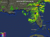
Tropical Storm Frances Intermediate Advisory Number 49a
Issued at: 1:48 AM EDT 9/6/04
Frances now over the northeast gulf of mexico and heading toward the Florida panhandle,
A hurricane warning remains in effect for the northwest gulf coast of Florida from anna maria island to destin.
At 2 am edt, 0600z, the tropical storm warning has been discontinued for lake okeechobee and the southwest Florida coast from south of bonita beach eastward to Florida city, and also for all of the Florida keys and Florida bay, including the dry tortugas.
A tropical storm warning is now in effect for the southwest coast of Florida from south of anna maria island to bonita beach, and for the east coast of Florida and georgia from north of jupiter inlet northward to altamaha sound georgia.
At 2 am edt, 0600z, the center of tropical storm frances was located near latitude 28.6 north, longitude 83.3 west or about 40 miles west of bayport Florida. This is also about 150 miles southeast of apalachicola Florida.
Frances is moving toward the west-northwest near 10 mph, and a gradual turn toward the northwest is expected by this afternoon. On the forecast track, the center of frances should continue moving over the warm waters of the northeastern gulf of mexico, and make landfall over the central portion of the Florida panhandle by this evening.
Maximum sustained winds recently reported by an air force reserve reconnaissance aircraft are near 65 mph with higher gusts. Some strengthening is possible during the next 24 hours, and frances could possibly become a hurricane again before making landfall in the Florida panhandle.
Frances remains a large tropical cyclone with tropical storm force winds extend outward up to 200 miles from the center, especially to the northeast. A sustained wind of 56 mph with a gust 62 mph was reported at st. Augustine on the Florida east coast. Over the northeast gulf of mexico, a sustained wind of 51 mph with a gust 59 mph was reported at a c-man weather station located about 25 miles southeast of apalachicola Florida.
The minimum central pressure recently reported by a reconnaissance aircraft was 981 mb, 28.97 inches.
Coastal storm surge flooding along with large and dangerous battering waves continue along the north Florida east coast, but will gradually subside later today. Storm surge flooding of up to 4 feet above normal levels is expected to subside on Monday. Along the southwest Florida coast, storm surge flooding of 2 to 4 feet above normal tide levels is expected south of tarpon springs. Storm surge flooding of up to 4 to 8 feet above normal tide levels is expected along the northeast gulf coast of Florida to the north of tarpon springs and also in apalachee bay.
Rainfall amounts of 6 to 10 inches, with locally higher amounts, are expected over portions of the southeastern united states, especially along and to the east of the wide path of frances.
Isolated tornadoes are possible today over portions of southern georgia and northern Florida.
Repeating the 2 am edt position, 28.6 n, 83.8 w. Movement toward, west-northwest near 10 mph. Maximum sustained winds, 65 mph. Minimum central pressure, 981 mb.
For storm information specific to your area, please monitor products issued by your local weather office.
The next advisory will be issued by the national hurricane center at 5 am edt.
Tim G
Well-Known Member
Frances Weakens Over Fla. Peninsula, Strengthening Forecast
Hurricane Ivan Strengthens To Category 4
UPDATED: 11:26 PM EDT September 5, 2004
STUART, Fla. -- Tropical Storm Frances continues its trek across the Florida peninsula after smashing ashore as a hurricane along a wide stretch of Florida's coast Coast.
The bad news is it will stay over the state until early Monday.
A hurricane warning has been expanded to cover the gulf coast to Destin in the Panhandle.
The storm has maximum sustained winds near 65 mph, and the core is 25 miles north-northwest of Tampa.
The storm was blamed for at least three deaths in Florida, including two people who were killed in central Palm Beach County Saturday when their roof caved in during the hurricane. Another man was killed when his car hit a tree near Gainesville, and a woman was killed when a tree fell on her mobile home in Alachua County.
There were two earlier deaths in the Bahamas, where thousands were forced from their homes.
Frances' wind and water slammed swaths of Florida with fire-hose force Sunday, submerging entire roadways and tearing off rooftops even as the storm weakened and crawled inland with heavy rain in its wake.
More than 5 million people lost power.
Frances' top sustained winds have dropped to near 65 mph, but forecasters say it could regain hurricane strength once it is over the Gulf of Mexico.
Florida Gov. Jeb Bush and 20 state and federal emergency officials surveyed damage as they flew from Tallahassee to West Palm Beach. The governor said it was too early to assess the extent of the devastation, although it doesn't appear to be as bad as the damage caused by Hurricane Charley last month.
More than 13 inches of rain fell along Florida's central east coast and caused scattered flooding as a weakened Frances edged across the state toward Tampa and the Gulf of Mexico. It left behind leveled trees and power lines, tangled traffic lights and beachfront roads littered with coconuts, avocados and tree limbs.
One woman who rode out the storm in a mobile home in Fort Pierce said she "was just waiting for the house to blow down." hers did not, but others weren't as lucky. Some evacuees at a school in Martin County had to move to another shelter when the roof was partially blown off.
The hurricane shut down much of Florida on the usually busy Labor Day weekend. But, airports have reopened in Miami and Fort Lauderdale, and officials have told evacuees there they can return home.
Across the state in Panama City, however, tourists are cutting short their holiday weekend, checking out of hotels early as the storm heads their way.
A hurricane warning is in effect from the mouth of the Suwannee River to Anna Maria Island, Fla.. A hurricane warning is now in effect for the gulf coast of Florida, from Anna Maria Island to Destin. The hurricane warning has been downgraded to a tropical storm warning for the east coast of Florida, from north of Jupiter Inlet northward to Flagler Beach, including Lake Okeechobee. All warnings from Jupiter Inlet southward to Florida City have also been discontinued.
A tropical storm warning remains in effect for the Florida peninsula, on the west coast, from south of Anna Maria Island southward around the peninsula to Ocean Reef, and for all of the Florida Keys, including Florida Bay and the Dry Tortugas. A tropical storm warning also remains in effect from north of Flagler Beach to Altamaha Sound.
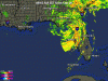
At 11 p.m. EDT, the center of Tropical Storm Frances was located by radar and surface observations near latitude 28.3 north, longitude 82.7 west, or about 25 miles north-northwest of Tampa.
Frances is moving toward the west-northwest near 8 mph, and a turn toward the northwest is expected during the next 24 hours. The center of Frances is at the gulf coast and is forecast to move over the waters of the northeastern Gulf of Mexico on Monday before moving inland over the Florida panhandle in about 24 hours.
Maximum sustained winds are near 65 mph, with higher gusts. Some strengthening is possible during the next 24 hours and there is chance that Frances could again become a hurricane.
Tropical storm force winds extend outward up to 200 miles from the center.
Coastal storm surge flooding along with large and dangerous battering waves continue along the north Florida east coast, but should gradually subside. Storm surge flooding of 5 feet above normal levels is expected in Lake Okeechobee. Along the southwest Florida coast, storm surge flooding of 1 to 3 feet above normal tide levels is expected south of the path of Frances. Storm surge flooding of up to 4 to 6 feet above normal tide levels is expected along the northeast gulf coast of Florida.
Rainfall amounts of 8 to 12 inches, with locally higher amounts, to near 20 inches, are expected over the southeastern United States.
Isolated tornadoes are possible over portions of central and north florida today.
Florida Keeps Wary Eye On Ivan
Meantime, the National Hurricane Center is warning Florida residents about another storm.
Earlier Sunday, Hurricane Ivan was a tropical storm. Now it's a Category 4 hurricane with winds of 135 mph. Forecasters say Ivan could reach Florida by next week. The storm is on track to reach the Bahamas this Friday.
A tropical storm watch is in effect for Grenada and Dependencies, while a hurricane watch remains in effect for Barbados. Interests elsewhere in the Lesser Antilles should monitor the progress of Ivan.
It's the fifth hurricane of the Atlantic season, the fourth major one, and forecasters say it will probably grow even stronger.
Ivan is located near latitude 10.6 north, longitude 48.5 west, or about 760 miles east-southeast of Barbados. That's too far away to tell with any certainty whether it will hit the United States, but forecasters say Florida residents should keep an eye on it -- especially after being hit by back-to-back hurricanes, Charley and Frances.
Bahamas Sees Widespread Damage
After two days of roaring winds and severe flooding, residents of the Bahamas are getting a look at damage left by Hurricane Frances.
The storm left at least two people dead and one missing. Officials say that death toll could rise. Hospital officials say at least five people sustained minor injuries, including a toddler who was cut by flying glass.
The northern island of Grand Bahama appeared particularly hard-hit. Several neighborhoods are under water, and severed power lines are hidden among debris on the ground.
Parts of the Grand Bahama airport remain flooded, and electricity is out on the island of 50,000 residents.
As Frances Weakens, Looters Strike
Police in several Florida counties are reporting that looters are following in the wake of Hurricane Frances.
Orlando area authorities said 10 thieves used a stolen car to smash open a clothing store. The robbers reportedly made off with about $10,000 worth of clothes.
In another case, two men were arrested as they tried to use a chain saw to steal an ATM.
In Palm Beach County, about a half-dozen sheriff's vehicles chased a car full of suspected looters down Interstate 95. Three suspects were quickly arrested, though a fourth escaped on foot. A spokesman said the final suspect was tracked down through the cell phone he left behind.
Several other people have been arrested for looting elsewhere. As one sheriff put it, the "jackals" are out there -- just waiting to pounce."
Damage, Injuries Tough To Gather
Specifics on damage and injuries will be impossible to gather until after the storm passes, said Craig Fugate, the state's director of emergency management.
In Palm Beach County, a large sinkhole shut down a section of Interstate 95 on Sunday. The Florida Highway Patrol closed a northbound section of the interstate in Palm Beach County. Southbound lanes could be affected soon because the sinkhole is growing.
Elsewhere, a section of road was washed out in a residential area of Jensen Beach along the Indian River. In the same area, a marina and some boats were damaged.
In Stuart, where the eye came ashore, the facade at a flooring store collapsed, as did the roof of a storage shed at a car dealership.
At the entrance to Kennedy Space Center, a replica of the Mercury-Redstone rocket that Alan Shepard rode into space was knocked over onto its side.
In Martin County, 630 people taking shelter at a school had to move to another shelter when part of the roof blew off, flooding 16 rooms. More than 300 people were able to remain in the school.
Four people were hospitalized in Boynton Beach after breathing carbon monoxide fumes from a generator that was running in a house.
Officials said virtually the entire state faces potential damage from wind and heavy rain. Florida Gov. Jeb Bush urged Floridians to "sit tight" and wait until the danger from Hurricane Frances passes.
Frances smashed into the state's Atlantic coast near Stuart overnight and then began to weaken. Although damage reports are beginning to roll in, officials said it is still too dangerous to send rescuers and response teams out to search for victims and damage.
Bush said his brother, President George W. Bush, has ordered the release of federal disaster funds and emergency resources to aid people affected by Hurricane Frances. The declaration makes federal and state assistance available to individuals, families and local governments.
Currently, the declaration covers Brevard, Indian River, Martin, Palm Beach and St. Lucie counties for individual assistance. Other counties may be designated at a later time after Hurricane Frances passes through the state. All 67 county governments are eligible to apply for federal assistance toward the costs of debris removal and emergency services related to the storm.
Shelters are providing a safe haven for some 80,000 residents and tourists, some of whom were still arriving early Sunday morning.
Airports serving Fort Lauderdale, Miami and Melbourne have shut down. The Kennedy Space Center and major amusement parks were closed.
Frances shattered windows, toppled power lines and flooded neighborhoods in the Bahamas, driving thousands from their homes. The Freeport airport was partially submerged in water.
Frances' arrival came three weeks after Hurricane Charley killed 27 people and caused billions of dollars in damage in southwestern Florida.
For some Floridians, the second storm couldn't arrive soon enough. "I just want it to be quick. Just get it over with," said Woodeline Jadis, 20, tired of waiting at a shelter in Orlando.
"This is the time to show some resolve and not be impatient," the governor said. "This is a dangerous, dangerous storm."
The largest evacuation in state history, with 2.8 million residents ordered inland, sent 70,000 residents and tourists into shelters. The storm shut down much of Florida at the start of the usually busy Labor Day weekend.
Some evacuees, frustrated by Frances' sluggish pace, decided to leave shelters Saturday and return later.
Deborah Nicholas dashed home from a Fort Pierce shelter to take a shower, but stayed only a few minutes when the lights started flickering and trees began popping out of the ground. She has slept in a deck chair at a high school cafeteria since Wednesday.
"I'm going stir crazy," Nicholas said. "I'm going to be in a straitjacket by Monday. I don't know how much longer I can take it. Have mercy."
Ron and Virginia Pastuch went home after spending two days at a Palm Bay shelter. Pastuch said he had never been in a shelter before. "It's the first time, and the last time, too," he said.
Roads, streets and beaches were mostly deserted -- the occasional surfer notwithstanding. Roads were littered with palm fronds and other debris. Businesses were shuttered and even gas stations were closed, their empty pumps covered with shrink wrap.
The storm meant extended vacations for about 10,000 passengers on nine Carnival Corp. ships unable return to Miami's port on schedule. They were expected to arrive late Sunday or Monday.
A U.S. Coast Guard helicopter rescued a man and his cat riding out the storm on a sailboat anchored in Biscayne Bay. At Palm Beach International Airport, the roof and a door were blown off a hangar.
Kevin Palmer, a photographer in Palm Beach County, said the wind blew so hard at his front door that it was making the copper weather stripping around it vibrate and shriek violently.
"It's become our high-gust alarm," Palmer said. "It sets the tone for your ambience when you've got the rumbling outside, you have this screeching from the weather stripping and you keep wondering if that thumping you just heard is another tree going over or a coconut going flying."
Hurricane Ivan Strengthens To Category 4
UPDATED: 11:26 PM EDT September 5, 2004
STUART, Fla. -- Tropical Storm Frances continues its trek across the Florida peninsula after smashing ashore as a hurricane along a wide stretch of Florida's coast Coast.
The bad news is it will stay over the state until early Monday.
A hurricane warning has been expanded to cover the gulf coast to Destin in the Panhandle.
The storm has maximum sustained winds near 65 mph, and the core is 25 miles north-northwest of Tampa.
The storm was blamed for at least three deaths in Florida, including two people who were killed in central Palm Beach County Saturday when their roof caved in during the hurricane. Another man was killed when his car hit a tree near Gainesville, and a woman was killed when a tree fell on her mobile home in Alachua County.
There were two earlier deaths in the Bahamas, where thousands were forced from their homes.
Frances' wind and water slammed swaths of Florida with fire-hose force Sunday, submerging entire roadways and tearing off rooftops even as the storm weakened and crawled inland with heavy rain in its wake.
More than 5 million people lost power.
Frances' top sustained winds have dropped to near 65 mph, but forecasters say it could regain hurricane strength once it is over the Gulf of Mexico.
Florida Gov. Jeb Bush and 20 state and federal emergency officials surveyed damage as they flew from Tallahassee to West Palm Beach. The governor said it was too early to assess the extent of the devastation, although it doesn't appear to be as bad as the damage caused by Hurricane Charley last month.
More than 13 inches of rain fell along Florida's central east coast and caused scattered flooding as a weakened Frances edged across the state toward Tampa and the Gulf of Mexico. It left behind leveled trees and power lines, tangled traffic lights and beachfront roads littered with coconuts, avocados and tree limbs.
One woman who rode out the storm in a mobile home in Fort Pierce said she "was just waiting for the house to blow down." hers did not, but others weren't as lucky. Some evacuees at a school in Martin County had to move to another shelter when the roof was partially blown off.
The hurricane shut down much of Florida on the usually busy Labor Day weekend. But, airports have reopened in Miami and Fort Lauderdale, and officials have told evacuees there they can return home.
Across the state in Panama City, however, tourists are cutting short their holiday weekend, checking out of hotels early as the storm heads their way.
A hurricane warning is in effect from the mouth of the Suwannee River to Anna Maria Island, Fla.. A hurricane warning is now in effect for the gulf coast of Florida, from Anna Maria Island to Destin. The hurricane warning has been downgraded to a tropical storm warning for the east coast of Florida, from north of Jupiter Inlet northward to Flagler Beach, including Lake Okeechobee. All warnings from Jupiter Inlet southward to Florida City have also been discontinued.
A tropical storm warning remains in effect for the Florida peninsula, on the west coast, from south of Anna Maria Island southward around the peninsula to Ocean Reef, and for all of the Florida Keys, including Florida Bay and the Dry Tortugas. A tropical storm warning also remains in effect from north of Flagler Beach to Altamaha Sound.
At 11 p.m. EDT, the center of Tropical Storm Frances was located by radar and surface observations near latitude 28.3 north, longitude 82.7 west, or about 25 miles north-northwest of Tampa.
Frances is moving toward the west-northwest near 8 mph, and a turn toward the northwest is expected during the next 24 hours. The center of Frances is at the gulf coast and is forecast to move over the waters of the northeastern Gulf of Mexico on Monday before moving inland over the Florida panhandle in about 24 hours.
Maximum sustained winds are near 65 mph, with higher gusts. Some strengthening is possible during the next 24 hours and there is chance that Frances could again become a hurricane.
Tropical storm force winds extend outward up to 200 miles from the center.
Coastal storm surge flooding along with large and dangerous battering waves continue along the north Florida east coast, but should gradually subside. Storm surge flooding of 5 feet above normal levels is expected in Lake Okeechobee. Along the southwest Florida coast, storm surge flooding of 1 to 3 feet above normal tide levels is expected south of the path of Frances. Storm surge flooding of up to 4 to 6 feet above normal tide levels is expected along the northeast gulf coast of Florida.
Rainfall amounts of 8 to 12 inches, with locally higher amounts, to near 20 inches, are expected over the southeastern United States.
Isolated tornadoes are possible over portions of central and north florida today.
Florida Keeps Wary Eye On Ivan
Meantime, the National Hurricane Center is warning Florida residents about another storm.
Earlier Sunday, Hurricane Ivan was a tropical storm. Now it's a Category 4 hurricane with winds of 135 mph. Forecasters say Ivan could reach Florida by next week. The storm is on track to reach the Bahamas this Friday.
A tropical storm watch is in effect for Grenada and Dependencies, while a hurricane watch remains in effect for Barbados. Interests elsewhere in the Lesser Antilles should monitor the progress of Ivan.
It's the fifth hurricane of the Atlantic season, the fourth major one, and forecasters say it will probably grow even stronger.
Ivan is located near latitude 10.6 north, longitude 48.5 west, or about 760 miles east-southeast of Barbados. That's too far away to tell with any certainty whether it will hit the United States, but forecasters say Florida residents should keep an eye on it -- especially after being hit by back-to-back hurricanes, Charley and Frances.
Bahamas Sees Widespread Damage
After two days of roaring winds and severe flooding, residents of the Bahamas are getting a look at damage left by Hurricane Frances.
The storm left at least two people dead and one missing. Officials say that death toll could rise. Hospital officials say at least five people sustained minor injuries, including a toddler who was cut by flying glass.
The northern island of Grand Bahama appeared particularly hard-hit. Several neighborhoods are under water, and severed power lines are hidden among debris on the ground.
Parts of the Grand Bahama airport remain flooded, and electricity is out on the island of 50,000 residents.
As Frances Weakens, Looters Strike
Police in several Florida counties are reporting that looters are following in the wake of Hurricane Frances.
Orlando area authorities said 10 thieves used a stolen car to smash open a clothing store. The robbers reportedly made off with about $10,000 worth of clothes.
In another case, two men were arrested as they tried to use a chain saw to steal an ATM.
In Palm Beach County, about a half-dozen sheriff's vehicles chased a car full of suspected looters down Interstate 95. Three suspects were quickly arrested, though a fourth escaped on foot. A spokesman said the final suspect was tracked down through the cell phone he left behind.
Several other people have been arrested for looting elsewhere. As one sheriff put it, the "jackals" are out there -- just waiting to pounce."
Damage, Injuries Tough To Gather
Specifics on damage and injuries will be impossible to gather until after the storm passes, said Craig Fugate, the state's director of emergency management.
In Palm Beach County, a large sinkhole shut down a section of Interstate 95 on Sunday. The Florida Highway Patrol closed a northbound section of the interstate in Palm Beach County. Southbound lanes could be affected soon because the sinkhole is growing.
Elsewhere, a section of road was washed out in a residential area of Jensen Beach along the Indian River. In the same area, a marina and some boats were damaged.
In Stuart, where the eye came ashore, the facade at a flooring store collapsed, as did the roof of a storage shed at a car dealership.
At the entrance to Kennedy Space Center, a replica of the Mercury-Redstone rocket that Alan Shepard rode into space was knocked over onto its side.
In Martin County, 630 people taking shelter at a school had to move to another shelter when part of the roof blew off, flooding 16 rooms. More than 300 people were able to remain in the school.
Four people were hospitalized in Boynton Beach after breathing carbon monoxide fumes from a generator that was running in a house.
Officials said virtually the entire state faces potential damage from wind and heavy rain. Florida Gov. Jeb Bush urged Floridians to "sit tight" and wait until the danger from Hurricane Frances passes.
Frances smashed into the state's Atlantic coast near Stuart overnight and then began to weaken. Although damage reports are beginning to roll in, officials said it is still too dangerous to send rescuers and response teams out to search for victims and damage.
Bush said his brother, President George W. Bush, has ordered the release of federal disaster funds and emergency resources to aid people affected by Hurricane Frances. The declaration makes federal and state assistance available to individuals, families and local governments.
Currently, the declaration covers Brevard, Indian River, Martin, Palm Beach and St. Lucie counties for individual assistance. Other counties may be designated at a later time after Hurricane Frances passes through the state. All 67 county governments are eligible to apply for federal assistance toward the costs of debris removal and emergency services related to the storm.
Shelters are providing a safe haven for some 80,000 residents and tourists, some of whom were still arriving early Sunday morning.
Airports serving Fort Lauderdale, Miami and Melbourne have shut down. The Kennedy Space Center and major amusement parks were closed.
Frances shattered windows, toppled power lines and flooded neighborhoods in the Bahamas, driving thousands from their homes. The Freeport airport was partially submerged in water.
Frances' arrival came three weeks after Hurricane Charley killed 27 people and caused billions of dollars in damage in southwestern Florida.
For some Floridians, the second storm couldn't arrive soon enough. "I just want it to be quick. Just get it over with," said Woodeline Jadis, 20, tired of waiting at a shelter in Orlando.
"This is the time to show some resolve and not be impatient," the governor said. "This is a dangerous, dangerous storm."
The largest evacuation in state history, with 2.8 million residents ordered inland, sent 70,000 residents and tourists into shelters. The storm shut down much of Florida at the start of the usually busy Labor Day weekend.
Some evacuees, frustrated by Frances' sluggish pace, decided to leave shelters Saturday and return later.
Deborah Nicholas dashed home from a Fort Pierce shelter to take a shower, but stayed only a few minutes when the lights started flickering and trees began popping out of the ground. She has slept in a deck chair at a high school cafeteria since Wednesday.
"I'm going stir crazy," Nicholas said. "I'm going to be in a straitjacket by Monday. I don't know how much longer I can take it. Have mercy."
Ron and Virginia Pastuch went home after spending two days at a Palm Bay shelter. Pastuch said he had never been in a shelter before. "It's the first time, and the last time, too," he said.
Roads, streets and beaches were mostly deserted -- the occasional surfer notwithstanding. Roads were littered with palm fronds and other debris. Businesses were shuttered and even gas stations were closed, their empty pumps covered with shrink wrap.
The storm meant extended vacations for about 10,000 passengers on nine Carnival Corp. ships unable return to Miami's port on schedule. They were expected to arrive late Sunday or Monday.
A U.S. Coast Guard helicopter rescued a man and his cat riding out the storm on a sailboat anchored in Biscayne Bay. At Palm Beach International Airport, the roof and a door were blown off a hangar.
Kevin Palmer, a photographer in Palm Beach County, said the wind blew so hard at his front door that it was making the copper weather stripping around it vibrate and shriek violently.
"It's become our high-gust alarm," Palmer said. "It sets the tone for your ambience when you've got the rumbling outside, you have this screeching from the weather stripping and you keep wondering if that thumping you just heard is another tree going over or a coconut going flying."
Hank Scorpio
New Member
Well the worst seems to be over.... ????
Any updates from the world? Does anyone know if there was serious damage from the wind or flooding?
Any updates from the world? Does anyone know if there was serious damage from the wind or flooding?
General Grizz
New Member
MSNBC was shown at WDW today. . . apparently the parks are ready to be opened. Apparently the cave survived the storm. . . so I will be offline for a little while over the coming days on the trek back home. . .
(Kinda wish I stayed home. . . but I'm not complaining )
)
(Kinda wish I stayed home. . . but I'm not complaining
)chancellor
Member
Hank Scorpio said:Well the worst seems to be over.... ????
Actually, I just woke up and the weather is worse now than it was all day yesterday (in Tampa, anyway). We were on the "dry" (west) side of the storm yesterday, but now we're on the "wet" side of the storm. I don't know if it made any difference in Orlando, since they've been getting the "wet" side for quite a bit more time, but man it's nasty out right now.
At least my power is still on.
**crosses fingers, knocks wood, rubs rabbit's foot**
donsullivan
Premium Member
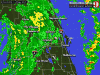
There are still outer band squalls this morning coming through Polk & Osceola county (south of Orlando) that are kicking up tornadoes.
Atta83
Well-Known Member
One reporter got hit by a flying peice of styrofoam fracturing her rib.FutureCEO said:I love how the weatherman are out there saying to go inside and its crazy. One day I would like to see one of them get hurt, not in a mean way but just to teach them a lesson
Register on WDWMAGIC. This sidebar will go away, and you'll see fewer ads.