The Official Hurricane Frances thread...

PhotoDave219

Well-Known Member
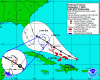
Well, its gonna hit somewhere between North Caronia and Miami, thats much is for sure. The latest "officail" track has it comming east of orlando. But depending on the computer model you look at (Thank you, Channel 9), it could go anywhere.

Unfortunetly the US Navy's model has it going south of port canevral and over Lake Buena Vista area before leaving florida north of tampa and heading into the gulf.
Which would suck, naturally.
 

Feta

Member
NemoRocks78 said:
Right now it isn't as strong as Charley was, and they aren't expecting it to get past Category 4. The central Bahamas are currently in a hurricane watch and the southeast Bahamas are under a hurricane warning.

It will now either continue on the same path that was made known earlier today or it will (hopefully) just barely miss us. Either way, we're going to get some type of effects. If it continues on the same path from earlier, it will make landfall in Daytona Beach at around 2pm Saturday. It would be out of the state 24 hours later.

This is all from the weatherman, who is saying this as we speak.

Well Nemo, the important thing is that it's way too early to tell what's going to happen. Our weathermen (ooops, I mean meteorologists - apology to the gender neutral sensitive), say this could easily become a category 5 storm - and they're not sure if it will or won't slow down some over the Bahamas. Most of the track forecasts seem to have it coming ashore around the cape to Daytona - so at least Orlando should be on the weaker western side of the storm. Unfortunately for us in Jacksonville, we might be on the eastern side of the storm and possibly the eye-wall. That's OK though, Orlando just got buzzed from Charlie - I guess it's our turn. Anyhoo, like I said, these things are way to erratic to predict much 3-4 days before they hit. We'll see.
 

miles1

Active Member
As much as my wife and I have lamented living here in Connecticut and dreamed of living in Florida, this is one of those times that gives me pause. Here we just get blizzards, floods, bone-chilling cold, occasional minor earthquakes, political conventions and a catagory one hurricane about once every ten years. All of these seem like minor inconveniences compared to what many of you are going through in Florida right now. I can't imagine having everything I own, not to mention my family's safety, threatened not only once but twice in one month. It must get nerve-wracking after a while.

No matter where this storm goes, it appears it will hit the state at such an angle that damage will be spread over a very wide area. This of course on top of what the last storm left.

A question for you Floridians: Would this year's weather give you a reason to move from the state? If you have moved to the state recently, would you have done so knowing what you know now?

We hope you all stay safe and we will keep you in our prayers.
 

FamilyMan

Account Suspended
Latest update... by the way, if the Hurricane actually follows this projected path, I'm Betty Crocker... http://www.nhc.noaa.gov/ftp/graphics/AT06/refresh/AL0604W5+GIF/010253W5.gif

I've never seen such an insane forecast... I mean the turn it takes north after it hits Orlando... this track makes no sense, and I believe that the storm will not take this path. (To be honest, I think it will be farther south upon landfall, these projections seem too far North to me, but I'm no weatherman. Oh well, we'll see what happens, eh?
 

prberk

Well-Known Member
You know, with a hurricane this large (the size of Florida itself), I really think most of Florida will be affected in some way, no matter where the eye hits (even though I know the direct hit is worst).

And now that the land is saturated from the last time, it trees could fall much more easily. Be sure to stock up now, and stay away from treelined areas of the house when the storm actually comes.

My prayers are with all no matter what.

Paul
 

Ringo8n24

Active Member
I, too, feel this is one of the most vague forecasts I have ever seen on a hurricane or tropical storm. I agree that the majority of Florida will feel something from it. Here on the MS Gulf Coast people have been cleaning out the supplies at WalMart just in case it comes into the Gulf next week. Man, do I feel for Florida right now. :(
 

scorp111

Well-Known Member
5am Map

The 5 AM map takes it further south again slightly, so that it would pass almost directly over WDW.

I am selfish, go away! (15 days before our trip) and don't want to see the parks get nailed.....

At the same time, my family is in Charleston, so I don't want it to turn to far northward either......
 

The Mom

Moderator
Premium Member
Again, it's too early to tell. A lot can happen in the next 48 hours!!! All I know is that I'm keeping a close eye on this, and will be as prepared as possible.
 

wannab@dis

Well-Known Member
Castaway Cay

Based on the information that Sloan provided and a map here, I highlighted Castaway Cay on the following map. The small blue circle is enlarged into the larger blue circle. The island that is in the middle of the red circle is Castaway Cay. This latest track has it going directly over the island.
 

Attachments

  • castawaycay.gif
    castawaycay.gif
    54.7 KB · Views: 261

SpongeScott

Well-Known Member
Here is a report/forecast from the National Hurricane Center. Good news? It sounds like they don't expect it to strengthen and it could lose some punch as it gets closer to Florida.

The second paragraph explains why they are forecasting the above track in the post above me. A lot goes into this, but these storms also seem to have a mind of their own sometimes too.

REPORTS FROM THE LATEST AIR FORCE RESERVE HURRICANE HUNTER
MONITORING FRANCES SHOW MAXIMUM FLIGHT-LEVEL WINDS AT 700 MB OF 123
KT...DOWN A LITTLE FROM THE EARLIER FLIGHT. HOWEVER...THE CENTRAL
PRESSURE HAS DROPPED TO 935 MB. BASED ON THIS...THE INITIAL
INTENSITY WILL REMAIN 120 KT FOR THIS ADVISORY. THE WSR-88D AT SAN
JUAN SHOWS THAT FRANCES HAS CONCENTRIC EYEWALLS...AND THE AIRCRAFT
DATA SHOWS THREE CONCENTRIC WIND MAXIMA. INDEED...ON THE LATEST
PASS THROUGH THE SOUTHEASTERN QUADRANT THE HIGHEST WIND WAS IN THE
MAXIMA ASSOCIATED WITH THE OUTER EYEWALL.

THE INITIAL MOTION IS A WOBBLY 285/15. FRANCES REMAINS ON THE SOUTH
SIDE OF A SUBTROPICAL RIDGE WHICH LARGE-SCALE MODELS FORECAST TO
WEAKEN SOMEWHAT OVER THE NEXT 72 HR. THIS SHOULD ALLOW THE
HURRICANE TO MOVE WEST-NORTHWESTWARD IN THE GENERAL DIRECTION OF
THE FLORIDA PENINSULA. DYNAMICAL MODEL GUIDANCE AGREES WITH THIS
SCENARIO...EXCEPT FOR THE GFDL WHICH CONTINUES TO CALL FOR A
UNREALISTIC LOOKING MOTION TOWARD THE NORTHWEST. THE OFFICIAL
FORECAST THROUGH 72 HR IS SHIFTED A LITTLE WEST OF THE PREVIOUS
TRACK BASED MAINLY ON THE INITIAL POSITION AND MOTION AND IS ON THE
LEFT SIDE OF THE DYNAMICAL GUIDANCE. AFTER 72 HR...THERE IS
DIVERGENCE IN THE GUIDANCE AS A SHORTWAVE RIDGE DEVELOPS NORTH OF
FRANCES OVER THE EASTERN UNITED STATES. THE OFFICIAL FORECAST
TRACK FOR THAT TIME IS SHIFTED TO THE SOUTHWEST OF THE PREVIOUS
TRACK...ALTHOUGH NOT AS FAR AS THE UKMET WHICH MARCHES FRANCES
WESTWARD ACROSS CENTRAL FLORIDA AND INTO THE GULF OF MEXICO.

THE INTENSITY FORECAST IS MODIFIED ONLY SLIGHTLY FROM THE PREVIOUS
PACKAGE. UPPER-LEVEL WINDS ARE FAVORABLE THROUGH AT LEAST 36-48
HR...SO FRANCES SHOULD REMAIN STRONG. A SLIGHT WEAKENING IS
INDICATED AT 72 HR BASED ON LAND INTERACTION AND SOME POSSIBLE
WESTERLY SHEAR. THE MAIN CONTROLLING FACTOR ON INTENSITY WILL BE
THE STRUCTURE OF FRANCES AND CONCENTRIC EYEWALL CYCLES...BOTH OF
WHICH ARE DIFFICULT AT BEST TO TIME. GIVEN THE CURRENT STRUCTURE
OF THE HURRICANE...CHANGES IN INTENSITY WILL LIKELY BE RELATIVELY
SLOW TO OCCUR.

FORECASTER BEVEN
 

wolf29

New Member
While I really do not want to be negative, the land interaction they discuss in 72 hours is when the storm begins to make landfall in the US. Other than slight fluctuations, there is no reason to believe that this storm will weaken before that time. Sea temperatures are warm, not much shear and no large land masses to disrupt the storm. Some models forecast the storm to slow a bit, which gives it time to strengthen. Obviously, these storms change hour to hour, but as of now everyone in the possible path of should hope for the best, but prepare for the worst.
 

chancellor

Member
Though there is still a wide margin of error, the computer models this morning seem to be converging on the east coast of Florida, somewhere between West Palm Beach and Jacksonville (more likely between Vero Beach and Daytona). One model still has the storm coming out through Tampa into the gulf, but most have it turning north into Georgia. Since this storm is so huge, I would think it's almost a guarantee that tropical storm force (if not hurricane force) winds will be felt across almost the entire state this weekend. It looks like Frances will take the exact opposite path of Charley, with their paths crossing in an "X" pattern right over Orlando. The possibility still exists for an early turn to the north before landfall, but that possibility seems less likely as time goes by.

And yes, the storm may "weaken" to a strong cat. 3 before landfall, but that won't mean much for most of the state (it may reduce some damage right around the eye, but everybody else will be in pretty much the same boat due to the size of the storm).

Edit to add link to computer models:
http://www.wunderground.com/tropical/tracking/at200406_model.html
 

chancellor

Member
wolf29 said:
While I really do not want to be negative, the land interaction they discuss in 72 hours is when the storm begins to make landfall in the US. Other than slight fluctuations, there is no reason to believe that this storm will weaken before that time. Sea temperatures are warm, not much shear and no large land masses to disrupt the storm. Some models forecast the storm to slow a bit, which gives it time to strengthen. Obviously, these storms change hour to hour, but as of now everyone in the possible path of should hope for the best, but prepare for the worst.

Normally I would agree with you, but I interpreted the discussion to mean that they expect some shear to develop before it hits Florida, which could reduce the storm somewhat. Not enough to make a huge difference, except maybe to the people right in the path of the eye. Of course, that's all guesswork at this point.
 

wolf29

New Member
I did read the portion of the discussion forecasting possible shear, but that is at the 72 hour point. At that time a fair portion of the storm will have possibly made landfall. The big problem is the size of this storm and the fact that it is already a CAT 4 storm, so slight weakening makes it a CAT 3. While that is better, it is still a major storm. Another thing to pay attention to is the fact that the storm is forecast to possibly slow, giving it time to strengthen & linger in the area. Basically, for those of us in areas that experience these things, this time of year stinks. This storm missed us by about 100 miles, which really is not much, all thins condsidered. Until about Sunday night it was a distinct possibility that it would get us here. We wound up with less than an inch of rain and a little wind. Every time one of these things approaches, you just get ready and hope for the best. I get a few more gray hairs every storm season. Lets hope for all those in the path that they fare well and stay safe.
 

BwanaBob

Well-Known Member
Here we go again!

Well, all.... if you don't hear from me much in the next few days, you'll know why.

As of this morning, and because of what Charley did, were on full-support staffing. Just got word they're sending a convoy into Tampa for supplies to better distribute now before landfall. I'll try to keep everyone updated on what the local EOC's are doing.
 

Atta83

Well-Known Member
I was just thinking about this...dont know if many folks will do it though, but....I'll give it a shot... With the possibility of Frances heading near the way of there, I would buy an gas container, you know the ones I am talking about ....the are plastic and such. Well I would fill one up with extra gas just so I would have some in case I could not get any gas for a while....just a thought......I think this is what my dad did a few years ago when I was younger when we saw a nasty storm a comin....
 

BwanaBob

Well-Known Member
Atta83 said:
I was just thinking about this...dont know if many folks will do it though, but....I'll give it a shot...
FYI...EVERYONE does it!

More for holding gas for generators, chainsaws, and the like... not so much for cars.
 

Thebriarpatch

New Member
hurricane.gif
<!--endemo--> I am heading down Tommorrow.... If it is going to hit lets pray all are safe.

And for my own selfish reasons let it stay away on the weekend so I can see SM!!!!!!

Keep safe
 

Register on WDWMAGIC. This sidebar will go away, and you'll see fewer ads.

Back
Top Bottom