-
The new WDWMAGIC iOS app is here!
Stay up to date with the latest Disney news, photos, and discussions right from your iPhone. The app is free to download and gives you quick access to news articles, forums, photo galleries, park hours, weather and Lightning Lane pricing. Learn More -
Welcome to the WDWMAGIC.COM Forums!
Please take a look around, and feel free to sign up and join the community.
You are using an out of date browser. It may not display this or other websites correctly.
You should upgrade or use an alternative browser.
You should upgrade or use an alternative browser.
The Official Hurricane Jeanne thread
- Thread starter Tim G
- Start date
WDWScottieBoy
Well-Known Member
Don't you have old clothes or something, bedsheets, anything else that you can use besides towels?
Atta83
Well-Known Member
I would like to say that this was not me. i had my own towels thank you very much .mkt said:btw, as dave and I run out of towels, I would like to post a thanks to our ex-roommate for stealing most of ours when she moved out.
")
PhotoDave219
Well-Known Member
Its pretty much under control, we're keeping up....WDWScottieBoy said:Don't you have old clothes or something, bedsheets, anything else that you can use besides towels?
speck76
Well-Known Member
So...I am still stuck in Michigan.
My flight to Tampa for tonight was cxl, so I am booked on a flight into Palm Beach tomorrow morning, and I moved my car rental to there. Speck is still at the Vet in Orlando....hopefully.
The earliest flights with availability into Orlando or Tampa are for Thursday.
My flight to Tampa for tonight was cxl, so I am booked on a flight into Palm Beach tomorrow morning, and I moved my car rental to there. Speck is still at the Vet in Orlando....hopefully.
The earliest flights with availability into Orlando or Tampa are for Thursday.
NemoRocks78
Seized
speck76 said:My flight to Tampa for tonight was cxl, so I am booked on a flight into Palm Beach tomorrow morning, and I moved my car rental to there.
Everty time I pass by that airport and see another plane taking off, I go, "there's another plane off to civilization....." :lol:
Glad to hear you're getting back to FL speck.
Hurricane Jeanne Blamed For At Least Three Deaths
UPDATED: 2:37 pm EDT September 26, 2004
STUART, Fla. -- Hurricane Jeanne blasted ashore in Florida with drenching rains and 120 mph wind, tearing off rooftops, hurling debris through the air and sending huge waves crashing into buildings Sunday as it hit the same area battered by Frances three weeks ago. At least three people died.
At least 1.5 million homes and businesses were without power as Jeanne sliced across the central part of the state and weakened into a tropical storm. A Category 3 storm when it slammed into the east coast, Jeanne was the fourth hurricane to pummel Florida in a single season, something that has not happened since 1886 when Texas was the target.
Rain whipped sideways in sheets and sections of road were washed out by pounding waves as the Category 3 storm slammed into Florida's Atlantic coast just before midnight Saturday at Hutchinson Island near Stuart, about 35 miles north of West Palm Beach. The storm then swirled into central Florida, an area saturated by rain from two previous hurricanes.
Four hurricanes in one season represents an ordeal no state has faced since 1886, when Texas was the target. And the hurricane season runs through Nov. 30.
The Federal Emergency Management Agency has responded with the largest deployment in its history, eclipsing response for the 1994 earthquake in Northridge, Calif., and the 2001 terrorist attacks, FEMA Director Michael Brown said Sunday. The hurricanes and their remnants have forced the agency to deploy thousands of workers from Louisiana to Vermont, he said.
"You're going to have some areas that have been hit once, twice and sometimes maybe three times and just as you think you're making headway on debris removal for example, you've got to go back in," Brown said. "That's very frustrating I know for those who live in those communities."
National Hurricane Center Director Max Mayfield said it was the "first time ever that we know of" two landfalls that close in place and time.
One person was electrocuted in Miami early Sunday after touching a downed power line. Two people apparently drowned when the SUV they were driving plunged into a lake northwest of Fort Lauderdale during the storm.
In St. Lucie County north of West Palm Beach, police rescued five families when the hurricane's eye passed over late Saturday, including a wheelchair-bound couple in their 90s whose mobile home collapsed around them, emergency operations spokeswoman Linette Trabulsy said.
At the Ocean Breeze trailer park in nearby Jensen Beach, roofs of mobile homes were peeled back like the lids of sardine cans. Computer printers, hair dryers and propane canisters littered the road. Metal sidings clanged in the wind.
At least a foot of water rushed through some streets in Vero Beach, about 30 miles north of Stuart. About half of the 232 trailers at the Fairlane Harbor Mobile Home Estates had mostly wind damage, as water didn't seem to be high enough to get inside, park owner-manager Joe Stawara said.
"The last three weeks have been horrific and just when we start to turn the corner, this happens," Stawara said.
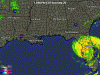
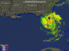
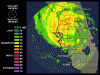
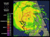
Tropical Storm Jeanne Intermediate Advisory Number 52a
Issued at: 1:48 PM EDT 9/26/04
Jeanne weakens to a tropical storm.
At 2 pm edt, 1800z, the hurricane warning along the west coast of florida from englewood to the suwannee river is downgraded to a tropical storm warning, and the tropical storm warning from bonita beach southward is discontinued.
At 2 pm edt, 1800z, the hurricane warning along the east coast of florida from north of jupiter inlet to cocoa beach is discontinued, the hurricane warning north of cocoa beach to st. Augustine is downgraded to a tropical storm warning, and the hurricane warning for lake okeechobee is discontinued.
A tropical storm warning remains in effect on the atlantic coast from north of cocoa beach to the savannah river, and on the gulf coast from north of bonita beach to destin.
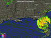
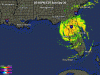
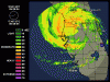
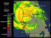
At 2 pm edt, 1800z, the center of tropical storm jeanne was located near latitude 28.3 north, longitude 82.2 west or about 20 miles southeast of brooksville Florida.
Jeanne is now moving toward the northwest near 10 mph. A gradual turn to the north is expected during the next 24 hours. On this track the center of jeanne will be moving over northern Florida tonight and early Monday.
Maximum sustained winds have decreased to near 70 mph, with higher gusts. Continued weakening is forecast over the next 24 hours.
Tropical storm force winds extend outward up to 175 miles from the center. Within the past hour, a wind gust to 76 mph was reported at orlando international airport, and a wind gust to 67 mph was reported at st. Petersburg.
The estimated minimum central pressure is 972 mb, 28.70 inches.
Coastal storm surge flooding, along with large and dangerous battering waves, will gradually subside along the Florida east coast.
Tides of 2 to 4 feet above normal are possible in the warned area along the Florida west coast, and higher at the heads of bays. Tides could possibly reach 3 to 6 feet in areas of onshore flow north of tampa bay.
Rainfall totals of 5 to 10 inches, with isolated higher amounts are possible near the path of jeanne.
Isolated tornadoes are possible over portions of the central and northern Florida peninsula and southeastern georgia today.
Repeating the 2 pm edt position, 28.3 n, 82.2 w. Movement toward, northwest near 10 mph. Maximum sustained winds, 70 mph. Minimum central pressure, 972 mb.
For storm information specific to your area, please monitor products issued by your local weather office.
The next advisory will be issued by the national hurricane center at 5 pm edt.
Issued at: 1:48 PM EDT 9/26/04
Jeanne weakens to a tropical storm.
At 2 pm edt, 1800z, the hurricane warning along the west coast of florida from englewood to the suwannee river is downgraded to a tropical storm warning, and the tropical storm warning from bonita beach southward is discontinued.
At 2 pm edt, 1800z, the hurricane warning along the east coast of florida from north of jupiter inlet to cocoa beach is discontinued, the hurricane warning north of cocoa beach to st. Augustine is downgraded to a tropical storm warning, and the hurricane warning for lake okeechobee is discontinued.
A tropical storm warning remains in effect on the atlantic coast from north of cocoa beach to the savannah river, and on the gulf coast from north of bonita beach to destin.
At 2 pm edt, 1800z, the center of tropical storm jeanne was located near latitude 28.3 north, longitude 82.2 west or about 20 miles southeast of brooksville Florida.
Jeanne is now moving toward the northwest near 10 mph. A gradual turn to the north is expected during the next 24 hours. On this track the center of jeanne will be moving over northern Florida tonight and early Monday.
Maximum sustained winds have decreased to near 70 mph, with higher gusts. Continued weakening is forecast over the next 24 hours.
Tropical storm force winds extend outward up to 175 miles from the center. Within the past hour, a wind gust to 76 mph was reported at orlando international airport, and a wind gust to 67 mph was reported at st. Petersburg.
The estimated minimum central pressure is 972 mb, 28.70 inches.
Coastal storm surge flooding, along with large and dangerous battering waves, will gradually subside along the Florida east coast.
Tides of 2 to 4 feet above normal are possible in the warned area along the Florida west coast, and higher at the heads of bays. Tides could possibly reach 3 to 6 feet in areas of onshore flow north of tampa bay.
Rainfall totals of 5 to 10 inches, with isolated higher amounts are possible near the path of jeanne.
Isolated tornadoes are possible over portions of the central and northern Florida peninsula and southeastern georgia today.
Repeating the 2 pm edt position, 28.3 n, 82.2 w. Movement toward, northwest near 10 mph. Maximum sustained winds, 70 mph. Minimum central pressure, 972 mb.
For storm information specific to your area, please monitor products issued by your local weather office.
The next advisory will be issued by the national hurricane center at 5 pm edt.
Jeanne weakens to Tropical Storm
September 26, 2004, 3:15 PM EDT
TALLAHASSEE -- Hurricane Jeanne smashed its way across Central Florida this morning, packing 85 mph winds and dumping heavy rain in a path that officials said was frighteningly similar to Hurricane Frances.
Jeanne's winds blew at 120 mph, making it a Category 3 storm at landfall, which was in St. Lucie County just before midnight in almost the exact spot where Hurricane Frances came ashore Sept. 5, said State Meteorologist Ben Nelson.
By 2 p.m., however, Jeanne had weakened to Tropical Storm status. Jeanne was centered about 20 miles southeast of Brooksville.
It was moving northwest near 10 mph and was forecast to move over northern Florida tonight and early Monday.
It was centered near latitude 28.3 north, longitude 82.2 west.
Earlier today, Jeanne weakened to a Category 1 storm, with 85 mph winds as it worked its way across land. Hurricane force winds were recorded from Brevard County all the way to Palm Beach and as far south as North Broward County, Nelson said. Hurricane force winds extended throughout the metro Orlando area, he said.
The storm is expected to slam the Tampa Bay area before turning north and heading for the Panhandle.
"It's a very signifcant storm at this point," said Department of Community Affairs Secretary Thad Cohen. "We're taking out the Frances playbook."
Although state officials have not confirmed any deaths, The Associated Press is reporting at least three deaths associated with the storm. One person was electrocuted in Miami early today after touching a downed power line, according to the report. Two people apparently drowned when the SUV they were driving plunged into a lake northwest of Fort Lauderdale during the storm.
Thousands of people woke up today without power in Orange County, with OUC reporting about 60,000 homes dark throughout its coverage area and Progress Energy reporting another 160,000 homes out scattered throughout Orange, Osceola, Polk and Highlands as of 8 a.m.
Orange County Sheriff Kevin Beary said that in Orange County it appeared that the damage wasn't as extensive as previous hurricanes because the other storms had knocked down the weak trees, and because of aggressive tree-trimming done in previous clean-ups.
In Sanford, waves crashing against the shoreline of Lake Monroe are threatening to wash away large sections of U.S. Highway 17-92, west of downtown Sanford.
The hurricane already is taking a toll on hospitals, including some hospitals still recovering from earlier hurricane damage.
The storm ripped off part of the roof at Palm Bay Hospital in Brevard County, said Alan Levine, who oversees state regulation of hospitals and nursing homes.
About 400 people were transferred from a shelter at an elementary school in Melbourne after parts of its roof flew off, police Lt. Jeff Koska said. No one was injured, and the evacuees were taken to another shelter, he said.
About 100 people at a similar shelter in Fort Pierce were transferred after its roof started leaking, but no one was hurt.
In Cocoa Beach about 80 miles north of Stuart, Paul and Ann Jutras weathered another storm in their reinforced house that they claimed was hurricane-proof.
Sitting two blocks from the Atlantic Ocean, the structure has two roofs -- in case one is damaged. In Frances, ``we got pounded for 37 hours, but the wind would blow for about 20 or 25 minutes and there would be a lull. This one, it's just not letting up at all,'' Paul Jutras said.
The generator failed at Sebastian Hospital in Indian River. In Stuart, the roof suffered significant damage at Martin Memorial Medical Center, which was still recovering from Frances, he said. Other hospitals in the area also feeling the effects, he added.
"The big issue is capacity,'' Levine said. "Most hospitals are full or nearly full already."
In West Pasco County, the storm ripped off a tarp covering part of the roof at Community Hospital of New Port Richey, which had been damaged in Hurricane Frances, he said.
"Their roof wasn't being done being repaired and they were holding it down with 250 sandbags," he said. As a result, some of the 200 patients may have to be evacuated to nearby Hudson, he said.
Nelson said no physical characteristics would explain why a storm would hit the same spot twice.
State officials said that the nearly 1 million customers in 17 counties without electrical power early today will rise as the swirling storm sweeps across the state."That number will increase as the day continues," said Mike DeLorenzo, a state emergency response leader.
I it (the flooding) very bad, Rob?mkt said:ok... daves asleep, so now I'm putting the towels down to stop the flooding
Register on WDWMAGIC. This sidebar will go away, and you'll see fewer ads.