The Official Hurricane Ivan thread...

TheDisneyGirl02

New Member
MKCP 1985 said:
Please throw me into the mix with Kadee, Ringo, freak, str8fan, bsanders, stingrock and others as the most recent projections have bad Ivan making landfall around Mobile Bay.QUOTE]

Will do! Please take care, everybody listed above and those who aren't listed and are in the path of the hurricane! You will all be in my thoughts and prayers!

TheDisneyGirl02
 

Tim G

Well-Known Member
<TABLE borderColor=#000000 cellSpacing=0 cellPadding=2 width="98%" border=1><TBODY><TR><TD bgColor=#ff0000><TABLE width="100%"><TBODY><TR><TD class=large>STORM STATUS</TD><TD class=small align=right>September 14, 10:29 AM EDT</TD></TR></TBODY></TABLE></TD></TR><TR><TD bgColor=#cccccc><TABLE cellSpacing=0 cellPadding=2 width="95%" border=0><TBODY><TR><TD colSpan=2>Name: Hurricane Ivan</TD></TR><TR><TD class=small vAlign=top>Location: About 435 Miles, South-Southeast of The Mouth Of The Mississippi River.
Lat/Long: 23.4N, 86.2W
Max Winds: 140 mph
Category: 4
</TD><TD class=small vAlign=top noWrap>Heading: North-Northwest
Speed: 8 mph
Pressure: 27.52 inches
</TD></TR></TBODY></TABLE></TD></TR></TBODY></TABLE>
Hurricane Ivan Advisory Number 49

Issued at: 9:29 AM CDT 9/14/04

Ivan weakens, but remains an extremely dangerous hurricane in the southern gulf of mexico

A hurricane warning remains in effect for the cuban provinces of pinar del rio, havana, city of havana, and the isle of youth.

At 10 am cdt, 1500z, the mexican government has downgraded the hurricane warning from tulum to progreso on the yucatan peninsula to a tropical storm warning.

A tropical storm watch remains in effect for the Florida keys from the seven mile bridge westward, including the dry tortugas.

A hurricane watch remains in effect for the northern gulf of mexico coast from morgan city louisiana eastward to st. Marks Florida, including greater new orleans louisiana. A hurricane warning will likely be required for a portion of the watch area this afternoon.

At 10 am cdt, 1500z, the center of hurricane ivan was located near latitude 23.4 north, longitude 86.2 west or about 435 miles, south-southeast of the mouth of the mississippi river.

Ivan is moving toward the north-northwest near 8 mph, and this motion is expected to continue over the next 24 hours.

Maximum sustained winds have decreased and are now near 140 mph, with higher gusts.
However, ivan remains an extremely dangerous category four hurricane. Fluctuations in intensity are common in major hurricanes and are expected over the next 24 hours.

Hurricane force winds extend outward up to 100 miles from the center, and tropical storm force winds extend outward up to 260 miles.

The minimum central pressure measured by an air force reserve unit reconnaissance aircraft was 932 mb, 27.52 inches.

Rains in cuba will be diminishing today.

Repeating the 10 am cdt position, 23.4 n, 86.2 w. Movement toward, north-northwest near 8 mph. Maximum sustained winds, 140 mph. Minimum central pressure, 932 mb.

For storm information specific to your area, please monitor products issued by your local weather office.
An intermediate advisory will be issued by the national hurricane center at 1 pm cdt followed by the next complete advisory at 4 pm cdt.
 

Tim G

Well-Known Member
Update Hurricane Ivan

Ivan Heading North

Caribbean I.R. Satellite Update

Image Delay = 30 mins.
 

Attachments

  • Gulf_ir_anim_10.gif
    Gulf_ir_anim_10.gif
    511.1 KB · Views: 129

Tim G

Well-Known Member
Deadly Hurricane Ivan Enters Gulf Of Mexico

UPDATED: 12:43 pm EDT September 14, 2004


PANAMA CITY BEACH, Fla. -- Frightened residents of the Gulf Coast from Florida's Panhandle to Louisiana's bayous were boarding up windows, packing and hitting the road Tuesday as powerful Hurricane Ivan charged in their direction. A state of emergency was declared in highly vulnerable New Orleans.

A hurricane watch was posted for a 420-mile-long swath from St. Marks in the Florida Panhandle, just south of Tallahassee, to New Orleans and Morgan City, La.

Authorities ordered or strongly urged hundreds of thousands of residents and tourists to evacuate coastal areas of the Florida Panhandle, Alabama, Mississippi and Louisiana. Schools were closed in New Orleans and parts of Florida, Mississippi and Alabama, and some areas started opening shelters. Panama City Beach was deserted at dawn Tuesday.

"This is a serious storm that requires serious action to get people out of harm's way," Alabama Gov. Bob Riley said.

Ivan, a killer blamed for at least 68 deaths in the Caribbean, was a Category 4 hurricane at late morning with top sustained wind at 140 mph, down from 160 mph -- Category 5 strength -- earlier.

"That's a monster they've got out there. I'm not taking any chances," Irvin Bruce said as he and his wife, Lillian, packed to leave the Copa Casino in Gulfport, Miss., to return to their home west of New Orleans.
If necessary, he said, they would keep going west.
Although on the western side of the watch area, New Orleans and its suburb of Jefferson Parish urged their population of around 1 million to head for higher ground. Suburban St. Charles Parish ordered its 49,000 residents to leave.

New Orleans is flanked by the Mississippi River and broad Lake Pontchartrain, and needs a system of canals and huge pumps to keep it dry because parts of it are as much as 10 feet below sea level.
The city hasn't taken a major direct hit from a hurricane since Betsy in 1965, which flooded some neighborhoods up to 7 feet deep. Many highways leading out of the metro area are prone to flooding, severely limiting escape routes.

The spot where the center of the storm would make landfall was anyone's guess, but New Orleans Mayor Ray Nagin noted that hurricane-strength wind -- at least 75 mph -- was possible as far as 100 miles out from Ivan's center. He declared a state of emergency for the city.
"We don't know if were going to get a punch in the mouth or a kick in the knee. But we're going to get hit," Jefferson Parish President Aaron Broussard said at a news conference.

Forecasters said its outer bands of wind and rain may begin lashing the coast as early as Wednesday.

At 11 a.m. Tuesday, Ivan was centered about 435 miles south-southeast of the mouth of the Mississippi River and about 470 miles south of Panama City Beach. It was moving north-northwest at 8 mph.
Oil and gas rigs in the Gulf of Mexico had been evacuated and hundreds of people abandoned fishing settlements on Mexico's Yucatan peninsula.

The Coast Guard had not restricted traffic on the lower Mississippi River below New Orleans but shipping companies voluntarily stopped operations late Monday and early Tuesday and ordered their vessels tied down.
"The vessel traffic is basically nonexistent," Petty Officer Nyx Cangemi said Tuesday.

Panhandle residents needed no more reminders of the perils of powerful hurricanes. Hurricanes Charley and Frances caused billions in damage and were blamed for more than 50 deaths statewide; Ivan could make landfall as the triumvirate's most powerful.

"If a Category 5 hits, you know what kind of debris could be flying through the air at 160 mph?" asked Bruce Butler, a keyboard player from Panama City Beach who was among those waiting in a 90-minute-long line Monday for plywood at a Home Depot.

The Mississippi National Guard had been placed on active duty.
All over low-lying southern Louisiana, residents made plans to leave.

"All of my guests have left," said Theresa Vegas, manager of the Sand Dollar Motel on vulnerable Grand Isle, south of New Orleans. "Most of the fishing boats have left the marina, or are in the process of leaving."

Hotels across western and northern parts of Louisiana began filling up with people seeking higher ground. "It is a bittersweet situation when your best business is during a disaster," Mike Radiky, general manager of the Lafayette Holiday Inn Central Holidome.

Most schools and colleges along the Panhandle closed. Military installations were sending at least 275 aircraft well away from Ivan's possible path.

While utility crews continued to bring power back to customers on the Florida Peninsula who were blacked out by Hurricane Frances, Panhandle customers were told to brace for trouble.

"Ivan is an extremely dangerous storm and we want our customers to have realistic expectations," said Gulf Power spokesman John Hutchinson. "The power is not going to be restored in just a few days if Ivan comes in as a Category 4 or 5 hurricane."
 

Ringo8n24

Active Member
This place has been crazy today. We have the Chiquita banana containers from the port moving north on trailers tying up traffic, the casinos are shut down, guests at hotels are being told to check out, etc. The stores here are completely out of everything, but we are depending on all of our snacks/drinks we bought for our trip to WDW on Saturday morning. We will have to stop at a WalMart on the way to replenish. We almost headed to WDW this morning to get a headstart out of here, but did not. I wish I would have now. They have a mandatory evacuation for my neighborhood as I am only 7 blocks from the Gulf of Mexico. Good luck to all else out there in Ivan's path and thanks to everyone out there for your prayers. I will be in touch. :)
 

SpongeScott

Well-Known Member
Mayor of New Orleans is saying that a direct hit will bring 12-18 feet of water into the city. I don't know how many of you know this, but New Orleans is about 4 feet below sea level; it kinda sits like in a bowl. You've got the Gulf to the south and a huge lake to the north. It won't take much for Lake Pontchartrain to be dumped into the city and that will be disastrous. Take care if you live there and seek higher ground, please.
 

Tim G

Well-Known Member
Coastal Residents Fear Hurricane Ivan

Associated Press
September 14, 2004, 11:06 AM EDT


Apprehensive coastal residents from Florida's Panhandle to Louisiana prepared to flee today from a slightly weakened Hurricane Ivan, which entered the Gulf of Mexico on a collision course with the Gulf Coast.

A hurricane watch was posted for a 420-mile-long swath from St. Marks in the Florida Panhandle, just south of Tallahassee, to New Orleans and Morgan City, La.

People in New Orleans and two nearby parishes, five coastal Florida counties and Alabama's Baldwin County were urged or ordered to leave coastal or low-lying areas Tuesday.

Ivan, which killed at least 68 people in seven islands or countries the Caribbean, was a strong Category 4 hurricane with top sustained wind of 140 mph. Forecasters expected Ivan to lose some strength before hitting the Gulf Coast but slow down over land, raising the risk of flooding from prolonged rain.

At 11 a.m. today, Ivan was centered about 435 miles south-southeast of the mouth of the Mississippi River and about 470 south of Panama City Beach, moving north-northwest at 9 mph.

Panama City Beach was deserted at dawn today, except for Lani Mucha, a former professional surfer. Now a Nashville, Tenn., landscape architect, he was driving home from a vacation on Florida's east coast when he decided to swing by the Gulf and look at the 1- to 2-foot waves that were preceding Ivan. He was disappointed he didn't have his surfboard.

"I really miss the ocean," said the former Southern California resident, who spent about an hour looking at the Gulf.

The storm, one of the most powerful hurricanes ever to hit the Caribbean, has so far been blamed for at least 68 deaths. It swept past Cuba's western tip Monday, drenching farm fields while simultaneously sending 20-foot waves toward shore.

Forecasters expected Ivan to lose some strength before hitting the Gulf Coast but slow down over land, raising the risk of flooding from prolonged rain. If Ivan hits Florida, it will be the third hurricane to hit the state in five weeks, joining Charley and Frances.

Panhandle residents, needing no more reminders of the perils that accompany powerful hurricanes, participated Monday in what's become an all-too-familiar drill -- stocking and shuttering homes in preparation for a storm. Hurricanes Charley and Frances caused billions in damage and were blamed for more than 50 deaths statewide; Ivan may still make landfall as the triumvirate's most powerful.

"If a Category 5 hits, you know what kind of debris could be flying through the air at 160 mph?" asked Bruce Butler, a keyboard player from Panama City Beach who was among those waiting in a 90-minute-long line Monday for plywood at a Home Depot.

Millions of residents along the coast were advised to, at the very least, begin paying close attention to Ivan. Mandatory evacuations were ordered in Escambia and Bay counties for low-lying bay and coastal areas; Escambia's order also included mobile homes.

Walton and Okaloosa counties enacted evacuation plans for campgrounds, mobile homes and low-lying areas; Walton's was mandatory, Okaloosa's was, for now, voluntary. Santa Rosa County was to announce its evacuation plan later Tuesday. At Hurlburt Field in Okaloosa County, the Air Force ordered everyone out except for essential crews.

Some parts of Louisiana were under voluntary evacuation orders and the state continued preparing for Saturday's election, including a proposed constitutional amendment that would ban homosexual marriages. Even parts of Mexico shuttled residents and tourists to higher ground and away from the Yucatan Peninsula.

Mississippi Gov. Haley Barbour declared a state of emergency Monday afternoon and signed an executive order placing the Mississippi National Guard on active duty. Hotels in inland Alabama filled with evacuees from that state's coastal regions.

Hotels across the western and northern parts of Louisiana began filling up with those seeking higher ground. "It is a bittersweet situation when your best business is during a disaster," Mike Radiky, general manager of the Lafayette Holiday Inn Central Holidome.

Most schools and colleges along Florida's Panhandle closed. Military installations were sending at least 275 aircraft well away from Ivan's possible path. Oil companies evacuated workers from rigs in the Gulf. And while utility crews continued to bring power back to those on the Florida Peninsula who lost it because of Frances' raging winds, Panhandle customers were told to brace for trouble.

"Ivan is an extremely dangerous storm and we want our customers to have realistic expectations," said Gulf Power spokesman John Hutchinson. "The power is not going to be restored in just a few days if Ivan comes in as a Category 4 or 5 hurricane."

Fulfilling the forecast early, incessant rain was adding to water dumped by Charley and Frances and was filling the St. Johns River to dangerous levels in central Florida. Primary roads were impassable in inland Seminole County northeast of Orlando.

"In Mullet Lake, I saw one man driving his car. He'd get out and walk in front with a stick to see how deep the water was," said Seminole Public Safety spokesman Alan Harris.

As the Panhandle winced and the Gulf Coast fretted over Ivan's possible path, other areas continued moving toward normal operations. Schools and government offices in many counties hit by Frances reopened their doors, Martin County in southwestern Florida lifted its curfew and hospitals in the Florida Keys began to reopen.

Keys residents were allowed Monday to return to their homes; officials said half of the county's 79,000 population adhered to last week's evacuation order.
Tourism officials said Keys vacationers, who were ordered out when forecasters thought Ivan could directly hit the island chain, were invited to begin returning Thursday. Businesses lost up to $20 million in sales because of the evacuation, according to Monroe County estimates.

"It looked bad. Can't fault them for that," said Jill Brown, 40, a waitress at a restaurant that closed for Ivan. "We could have stayed open a few more days. Bars were open. Anybody that stayed open made a fortune."

Meanwhile, a tropical depression moved closer to Puerto Rico and could become Tropical Storm Jeanne later Tuesday.
 

Tim G

Well-Known Member
Damage Caused By Ivan

Two people observe damage caused by Hurricane Ivan in Cancun, Mexico.
 

Attachments

  • 14243392.jpg
    14243392.jpg
    42.9 KB · Views: 124

Tim G

Well-Known Member
Cracked up House

A house destroyed by raging surf caused by Hurricane Ivan in seen in Harbour View, Jamaica, on Monday, Sept. 13, 2004.
The hurricane caused massive infra-structural damage and was responsible
 

Attachments

  • 14243392.jpg
    14243392.jpg
    13.7 KB · Views: 112

Tim G

Well-Known Member
Update Hurricane Ivan

Panhandle Ready To Flee From Hurricane Ivan

Gulf Coast I.R. Satellite Update

Image Delay = 30 mins.
 

Attachments

  • Gulf_ir_anim_11.gif
    Gulf_ir_anim_11.gif
    556.6 KB · Views: 123

Kadee

New Member
Well, we are sitting here waiting now. My husband's family (in Tennessee and Florida) are calling us frantically begging us to leave. My mother wants us to fly out to CA to her but all flights are now grounded at Mobile airport. I guess I'm staying put. My older sister lives ON the beach in Orange Beach, AL and is going to my younger sister's house who lives just a couple of miles inland. I am begging them to come up to my house which is about 20 miles further inland. AND my brother-in-law is a paramedic in Gautier MS and just went on a 48 hour shift and can not leave. I'll check in as long as I can. My town is right in the projected path for the eye of this thing.
 

prberk

Well-Known Member
Kadee said:
Well, we are sitting here waiting now. My husband's family (in Tennessee and Florida) are calling us frantically begging us to leave. My mother wants us to fly out to CA to her but all flights are now grounded at Mobile airport. I guess I'm staying put. My older sister lives ON the beach in Orange Beach, AL and is going to my younger sister's house who lives just a couple of miles inland. I am begging them to come up to my house which is about 20 miles further inland. AND my brother-in-law is a paramedic in Gautier MS and just went on a 48 hour shift and can not leave. I'll check in as long as I can. My town is right in the projected path for the eye of this thing.

My prayers are with you and the others along the path, Kadee.

Paul
 

Tim G

Well-Known Member
<TABLE borderColor=#000000 cellSpacing=0 cellPadding=2 width="98%" border=1><TBODY><TR><TD bgColor=#ff0000><TABLE width="100%"><TBODY><TR><TD class=large>STORM STATUS</TD><TD class=small align=right>September 14, 4:25 PM EDT</TD></TR></TBODY></TABLE></TD></TR><TR><TD bgColor=#cccccc><TABLE cellSpacing=0 cellPadding=2 width="95%" border=0><TBODY><TR><TD colSpan=2>Name: Hurricane Ivan</TD></TR><TR><TD class=small vAlign=top>Location: About 370 Miles South-Southeast of The Mouth Of The Mississippi River.
Lat/Long: 24.2N, 86.6W
Max Winds: 140 mph
Category: 4
</TD><TD class=small vAlign=top noWrap>Heading: North-Northwest
Speed: 9 mph
Pressure: 27.43 inches
</TD></TR></TBODY></TABLE></TD></TR></TBODY></TABLE>Hurricane Ivan Advisory Number 50

Issued at: 3:25 PM CDT 9/14/04

Hurricane warning issued along the northern gulf coast for extremely dangerous hurricane ivan,

At 4 pm cdt, 2100z, a hurricane warning is issued from grand isle louisiana to apalachicola Florida, including the greater new orleans area and lake pontchartrain. A hurricane warning means that hurricane conditions are expected within the warning area, generally within the next 24 hours. Preparations to protect life and property should be rushed to completion throughout the entire warning area.

The hurricane watch remains in effect from morgan city louisiana to west of grand isle.

At 4 pm cdt, a tropical storm warning is issued from intracoastal city louisiana to west of grand isle, and from east of apalachicola to yankeetown Florida. A tropical storm warning means that tropical storm conditions are expected within the warning area within the next 24 hours.

A tropical storm watch remains in effect for the Florida keys from the seven mile bridge westward, including the dry tortugas.

At 4 pm cdt, 2100z, all warnings in mexico and cuba have been discontinued by their respective governments.

At 4 pm cdt, 2100z, the center of hurricane ivan was located near latitude 24.2 north, longitude 86.6 west or about 370 miles south-southeast of the mouth of the mississippi river.

Ivan is moving toward the north-northwest near 9 mph, and this motion is expected to continue during the next 24 hours.
Maximum sustained winds are near 140 mph, with higher gusts. Ivan remains an extremely dangerous category four hurricane on the saffir-simpson hurricane scale. Fluctuations in intensity are common in major hurricanes and are possible over the next 24 hours. Ivan is expected to make landfall as a major hurricane, at least category three.

Ivan is a large hurricane.
Hurricane force winds extend outward up to 105 miles from the center, and tropical storm force winds extend outward up to 260 miles. Hurricane force winds are expected to spread inland up to about 100 miles near the path of ivan.

The minimum central pressure measured by a noaa hurricane hunter aircraft was 929 mb, 27.43 inches.

Coastal storm surge flooding of 10 to 16 feet above normal tide levels, along with large and dangerous battering waves, can be expected near and to the east of where the center makes landfall.
Lesser, but still significant surge values will be experienced where onshore flow occurs west of the center. Water levels are already running up to 1 foot above normal along the north gulf coast, and will be increasing overnight.
Rainfall accumulations of 10 to 15 inches, with isolated higher amounts, can be expected in association with ivan.

Repeating the 4 pm cdt position, 24.2 n, 86.6 w. Movement toward, north-northwest near 9 mph. Maximum sustained winds, 140 mph. Minimum central pressure, 929 mb.

For storm information specific to your area, please monitor products issued by your local weather office.
An intermediate advisory will be issued by the national hurricane center at 7 pm cdt followed by the next complete advisory at 10 pm cdt.
 

Tim G

Well-Known Member
Update Hurricane Ivan

Ivan closing in

Gulf Coast I.R. Satellite Update

Image Delay = 30 mins.
<!-- / message --><!-- attachments -->
 

Attachments

  • Gulf_ir_anim_12.gif
    Gulf_ir_anim_12.gif
    574.9 KB · Views: 97

Tim G

Well-Known Member
Deadly Hurricane Ivan Threatens Gulf Coast

UPDATED: 5:51 pm EDT September 14, 2004


PANAMA CITY BEACH, Fla. -- More than 1.2 million people in metropolitan New Orleans were warned to get out Tuesday as 140-mph Hurricane Ivan churned toward the Gulf Coast, threatening to submerge this below-sea-level city in what could be the most disastrous storm to hit in nearly 40 years.

Residents streamed inland in bumper-to-bumper traffic in an agonizingly slow exodus amid dire warnings that Ivan could overwhelm New Orleans with up to 20 feet of filthy, chemical-polluted water. About three-quarters of a million more people along the coast in Florida, Mississippi and Alabama were also told to evacuate.

Forecasters said Ivan, a killer blamed for at least 68 deaths in the Caribbean, could reach 160 mph and strengthen to Category 5, the highest level, by the time it blows ashore as early as Thursday somewhere along the Gulf Coast.

"Hopefully the house will still be here when we get back," said Tara Chandra, a doctor at Tulane University in New Orleans who packed up his car, moved plants indoors and tried to book a Houston hotel room. Chandra said he wanted to ride out the storm, but his wife wanted to evacuate: "All the news reports are kind of freaking her out."

At nearly 200 miles wide, Ivan could cause significant damage no matter where it strikes. Officials ordered or strongly urged an estimated 1.9 million people in four states to flee to higher ground.
"I beg people on the coast: Do not ride this storm out," Mississippi Gov. Haley Barbour said, urging people in other parts of the state to open their homes to relatives, friends and co-workers.

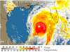
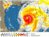
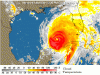
As of 5 p.m., Ivan was about 370 miles southeast of the mouth of the Mississippi River, moving northwest at about 9 mph.
The National Hurricane Center in Miami posted a hurricane warning for about a 300-mile swath from Apalachicola in the Florida Panhandle to New Orleans and Grand Isle in Louisiana. Forecasters said Ivan could bring a coastal storm surge of 10 to 16 feet, topped by large, battering waves.

New Orleans, the nation's largest city below sea level, is particularly vulnerable to flooding, and Mayor Ray Nagin was among the first to urge residents to get out while they can. The city's Louis Armstrong Airport was ordered closed Tuesday night.

Up to 10 feet below sea level in spots, New Orleans is a bowl-shaped depression that sits between the half-mile-wide Mississippi River and Rhode Island-size Lake Pontchartrain, relying on a system of levees, canals and huge pumps to keep dry.
The city has not taken a major direct hit since Betsy in 1965, when an 8- to 10-foot storm surge submerged parts of the city in 7 feet of water. Betsy, a Category 3 storm, was blamed for 74 deaths in Louisiana, Mississippi and Florida.

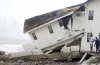
Experts said Ivan could be worse, sending water pouring over the levees, flooding to the rooftops and turning streets into a toxic brew of raw sewage, gas and chemicals from nearby refineries.
The mayor said that he would "aggressively recommend" people evacuate, but that it would difficult to order them to do so, because at least 100,000 in the city rely on public transportation and would have no way to leave. In addition, he said 10,000 people were in town for conventions, and there was nowhere for many of them to go except high floors in their hotels.

By midday Tuesday, traffic on Interstate 10, the major hurricane route out of New Orleans, was at a near standstill, and state police turned the interstate west of the city into a one-way route out. U.S. Highway 59, the old major route between New Orleans and Baton Rouge, also was jammed.

In the French Quarter, businesses put up plywood and closed their shutters. A few people were still hanging out at Cafe du Monde, a favorite spot for French roast coffee and beignets, and a man playing a trombone outside had a box full of tips.

"They said get out, but I can't change my flight, so I figure I might as well enjoy myself," said George Senton, of Newark, N.J., who listened to the music. "At least I'll have had some good coffee and some good music before it gets me."
Tourist Dee Barkhart, a court reporter from Baltimore, was drinking Hurricane punches at Pat O'Brien's bar.
"I looked into earlier flights, but they were hundreds of dollars more and I wasn't sure I could switch flights," she said. "I figure I'm happier sitting here drinking hurricanes than sitting at the airport worrying about them."
But Barkhart's drinks would have to be for the road. The bar planned to close by nightfall.

Elsewhere along the Gulf Coast, thousands of residents, gamblers and tourists crowded northbound roads. Motels were booked as far north as Jackson, Miss., and Montgomery, Ala.

Mississippi regulators ordered a dozen casinos along the state's 75-mile-long coast to close at noon Tuesday, but many gamblers pumped coins into the slot machines right up to closing.

"I don't worry about what's going to happen tomorrow. We can't control it anyway," said Ed Bak of Fairfield, Ohio, who dropped quarters into a machine at the President Casino.

In Alabama, Gov. Bob Riley ordered the evacuation of coastal resorts. "This is a serious storm that requires serious action to get people out of harm's way," he said.

Along Florida's Panhandle, the sounds of saws and drills filled the air as people put up boards to protect their homes and businesses.
"We are just hoping to still be here," said Matt Claxton, an assistant manager of a Perdido Key seafood restaurant as workers brought the patio furniture inside.
 

pinkrose

Well-Known Member
Kadee said:
Well, we are sitting here waiting now. My husband's family (in Tennessee and Florida) are calling us frantically begging us to leave. My mother wants us to fly out to CA to her but all flights are now grounded at Mobile airport. I guess I'm staying put. My older sister lives ON the beach in Orange Beach, AL and is going to my younger sister's house who lives just a couple of miles inland. I am begging them to come up to my house which is about 20 miles further inland. AND my brother-in-law is a paramedic in Gautier MS and just went on a 48 hour shift and can not leave. I'll check in as long as I can. My town is right in the projected path for the eye of this thing.

Kadee, please come futher inland. This is a bad storm. They are projecting it to be a cat 2 when it gets to us and I'm in central Al.
 

pinkrose

Well-Known Member
Here's the latest info in Alabama...

SPECIAL NOTE: ABC3340 will present a special thirty minute prime time special on Hurricane Ivan tonight at 8:30 p.m.

SERIOUS SITUATION DEVELOPING FOR ALABAMA...IVAN WILL BRING A DEVASTATING BLOW TO MUCH OF STATE WITH DAMAGING WINDS AND FLOODING RAINS...ALABAMIANS MUST PREPARE FOR THE WORST...

HEADLINES...
IVAN A LARGE AND DANGEROUS CATEGORY 4 HURRICANE...
HURRICANE WARNING FLAGS HOISTED FROM GRAND ISLE TO APALACHICOLA..
IVAN TO BRING DAMAGING WINDS...FLOODING RAINS AND TORNADOES TO INLAND AREAS...

Streaming Media Coverage Of Hurricane Ivan:
Video Update - James Spann (Tuesday morning)
Audio Update - Bill Murray (Tuesday afternoon)
Brian Peters Incredible Flight into a Cat 5 Ivan (part 1)
Brian Peters Incredible Flight into a Cat 5 Ivan (part 2)
Escaping the Hurricane: Interview with Matt Webster

See digital pictures from Brian Peters' flight into this historic hurricane.

A couple of spot reports at 5 PM (we will post more spot reports as as the hurricane gets closer to the coast)
Mobile Airport...clear...wind NE only 9 MPH
Mobile and Panama City Buoy...wind NE gusts to 34 with 11 foot waves. Both these buoys are well offshore from Mobile and panama City.

4PM CDT FAST FACTS ON HURRICANE IVAN:
POSITION: Latitude 24.2 N, Longitude 86.6 W
370 miles SSE of the mouth of the Mississippi River
MOVEMENT: NNW 9 MPH...
MAX SUSTAINED WIND: 140 MPH gusts to 165...still category 4
LOWEST PRESSURE: 929 millibars, 27.43 inches

LATEST WATCHES/WARNINGS
A hurricane warning is now in effect from Grand Isle, LA to Apalachicola, FL. A hurricane watch is in effect from Morgan City to west of Grand Isle in Louisiana. A tropical storm warning is in effect from Intracoastal City, LA to west of Grand Isle and east of Apalachicola to Yankeetown in Florida. A Tropical Storm Watch remains in effect for the Lower Florida Keys.

HERE IS THE LATEST ON HURRICANE IVAN AT 345PM CDT...
*Ivan looks like it is becoming bette oragnized again on satellite photos...
*Latest reconnaissance report shows pressure drop of 2 mb to 929mb
*Ivan will make ladnfall as Category 4 or strong Category 3 hurricane. It will be similar in strength to Alabama's benchmark hurricane...Hurricane Frederic of 1979
*The 4 pm official NHC track takes the hurricane over the western end of Mobile Bay. It then moves to a point just southwest of Birmingham by 7 a.m. Friday morning and then exits the state near Valley Head Friday afternoon.
*This track means that much of the state will be in the path of some of the worst hurricane conditions our state has seen. The NHC seems pretty confident about this forecast, but still cautions that Ivan's track could vary by 100 miles or more at this point and that severe weather conditions will impact a wide area.
*The NWS in Birmingham warns emphatically that Thursday and Friday will be terrible weather days and that there will be extensive clean up over the weekend.
*There is an increasing concern that Ivan might slow down during its transit over Alabama. The new ETA keeps us in heavy rain until Friday evening. This could increase rainfall amounts.
*Bottom line is that confidence of a landfall somewhere at or near the Alabama Gulf coast continues. The highest strike probabilities are at Mobile and Gulfport and have increased slightly since the last advisory. You say, where is Buras, LA? They have the highest strike probabilities. Buras is near the mouth of the Mississippi River and Ivan is forecast to pass within 60 miles of there Wednesday night on its way to the coast.
*A storm surge of 10-16 feet above normal is expected near and to the east of where the center makes landfall.

LOCAL WATCHES
*A High Wind Watch and Flash Flood Watch will be issued for Wednesday night through Friday for a stripe across Alabama from Sumter/Greene/Marengo Counties curving over and down to Lowndes/Montgomery/Pike Counties.
*A High Wind Watch and Flash Flood Watch will be issued starting Thursday into Friday for the rest of North Central and Central Alabama.

What kind of impact can we expect here in Central Alabama?
CENTER TRACK
The center of Ivan is expected to move across Hale... Bibb... Chilton... Shelby... Jefferson... Blount... St. Clair... Etowah... Marsahll... DeKalb... Jackson and Cherokee Counties...Thursday evening through Friday morning.
TIMING
The worst weather will be in the Birmingham area between 10pm Thursday night and 6 am Friday morning, a little later in counties to the northeast...a little earlier to the southwest.
WIND
Sustained hurricane force winds will extend will into Central Alabama. The NWS expects sustained winds to reach 60-70 mph across all of Central Alabama with gusts to 70-90 mph.
POWER OUTAGES
All of Central Alabama will experience sustained winds of 30 mph for up to as long as 30 hours. This prolonged wind event combined with saturated cloud will result in the uprooting of literally hundreds of thousands of trees. Alabama Power is warning that some customers from Demopolis to Montgomery to Phenix City could be without power for up to two weeks. Major power outages will occur all of the state.
HEAVY RAINFALL
The NWS has increased the expected rainfall amounts to between 6 and 12 inches, especially east of the center's track. Near the center, 4 to 8 inch amounts will be common.
TORNADOES
There will be a significant threat of tornadoes on Thursday night and Friday morning over Alabama, to the east of the center track.

FREQUENTLY ASKED QUESTIONS
On the NHC track, with the center of Ivan passing from Mobile Bay to Birmingham, here are some answers to the many questions we are getting in the office. These answers are for people in north and central Alabama (not coastal residents):
WHAT DO TO PREPARE? Stock up on food and supplies so you can be ready for an extended power outage on the order of several days. You can also have any dead trees or tree limbs trimmed back. Have batteries and flashlights available, as well as a battery powered radio. Don't forget supplies for pets, and remember kids might not have their Gamecubes and computers going. Have something for the family to do with no power. You should bring in any outdoor furniture, toys, garden tools, trash cans or items that could be blown about by strong winds.
I LIVE IN A MOBILE HOME. DO I NEED TO LEAVE? You do not need to leave today, but make plans on having a place to go beginning tomorrow. I would imagine shelters will be opened for mobile home residents, and we will have them on TV and post them on our web site as soon as we get them. It is NOT advisable for those in mobile homes to stay in them during the peak of the hurricane conditions Thursday afternoon through Friday morning. The two inland fatalities from Opal in 1995 came from a tree falling onto a mobile home. Contact friends and relatives and have a place to go beginning tomorrow.
WILL SCHOOL BE OPEN ON THURSDAY AND FRIDAY? No school closing decisions have been made at this time; they will be posted on the web site and they will run on ABC 33/40 as soon as we get them. This is a serious situation. We urge school administrators and heads of other organizations to plan for the worst.

IMPACTS ON COASTAL AREA OF ALABAMA/NORTHWEST FLORIDA
WARNINGS
A hurricane warning is now in effect from Grand Isle, LA to Apalachicola, FL.
WIND
Hurricane Ivan is expected to be a Category 3 hurricane at landfall with max winds of 130 mph. This will be comparable to Hurricane Frederic in 1979.
STORM SURGE
The NWS in Mobile has predicted that storm surge levels will reach 9-13 feet over SW Alabama and 8-11 feet over the western Florida Panhandle.
RAINFALL
12 inches will occur over Mobile and Baldwin Counties. Heavy rain will fall over the entire state. See our Central Alabama impacts below for more specific information.

MODEL DISCUSSION
The 12z ETA run carries the storm to near the mouth of the Mississippi River at 1 a.m. Thursday morning, just to near Slidell at 7am and into southern Mississippi by Thursday evening. From there it moves it slowly north into Mississippi and into North Alabama Friday night.

The 12Z has it positioned 125 miles south of the Alabama coast Wednesday evening, then takes it inland near the mouth of Mobile Bay Thursday morning. It then moves slowly NNE to a point just north of Montgomery around 1am Friday morning and to Gadsden by 7 am Friday morning.

The 06Z GDFL carries it over Grand Isle, LA, then across Mississippi, crossing the NW tip of Alabama by early Friday morning. It makes landfall with a central pressure of 945 mb, about consistent with the NHC forecast.

Last evening's UKMET agreed with a landfall in the Mobile/Pensacola area.

Here is the spread of the track models.

EVACUATION INFORMATION
...Mandatory evacuation in effect for all of Baldwin County south of I-10.
...At 7am, a mandatory evacuaion of all residents and visitors went into effect for Alabama's Pleasure Island...including Orange Beach, Gulf Shores, Ono Island and Fort Morgan.
...Mandatory evacuations have been in effect since last evening for mobile home and barrier islands in Northwest Florida.
...In Louisiana...Voluntary evacuations are underway in Orleans, Jefferson, lower St. Bernard and St. Tammany Parishes. Mandatory evacuations are in effect in St. Charles Parish and in Plaqeumines Parish south of Jesuit Bend and on East Bank, as well as Grand Isle.
...I-55 out of New Orleans has been coverted to only northbound travel. The northbound side was already down to one lane due to construction.

HISTORIC FLOODING EVENT AHEAD FOR APALACHIANS?
The NHC is warning that steering currents are weakening and the storm could slow down. They give an ominous statement about it slowing after landfall over the Apalachians. This could produce a serious flood event.
 

Tim G

Well-Known Member
Hurricane Ivan Intermediate Advisory Number 50a

Issued at: 6:41 PM CDT 9/14/04

Extremely dangerous hurricane ivan headed for the northern gulf coast

A hurricane warning is in effect from grand isle louisiana to apalachicola Florida, including the greater new orleans area and lake pontchartrain. A hurricane warning means that hurricane conditions are expected within the warning area, generally within the next 24 hours. Preparations to protect life and property should be rushed to completion throughout the entire warning area.

A hurricane watch remains in effect from morgan city louisiana to west of grand isle.

A tropical storm warning is in effect from intracoastal city louisiana to west of grand isle, and from east of apalachicola to yankeetown Florida. A tropical storm warning means that tropical storm conditions are expected within the warning area within the next 24 hours.

A tropical storm watch remains in effect for the Florida keys from the seven mile bridge westward, including the dry tortugas.

At 7 pm cdt, 0000z, the eye of hurricane ivan was located near latitude 24.7 north, longitude 87.0 west or about 325 miles south-southeast of the mouth of the mississippi river.
Ivan is moving toward the north-northwest near 10 mph, and this motion is expected to continue during the next 24 hours.
Maximum sustained winds are near 140 mph, with higher gusts. Ivan remains an extremely dangerous category four hurricane on the saffir-simpson hurricane scale. Fluctuations in intensity are common in major hurricanes and are possible over the next 24 hours. Ivan is expected to make landfall as a major hurricane, at least category three.

Ivan is a large hurricane. Hurricane force winds extend outward up to 105 miles from the center, and tropical storm force winds extend outward up to 260 miles. Hurricane force winds are expected to spread inland up to about 100 miles near the path of ivan.
The minimum central pressure measured by a noaa hurricane hunter aircraft was 929 mb, 27.43 inches.

Coastal storm surge flooding of 10 to 16 feet above normal tide levels, along with large and dangerous battering waves, can be expected near and to the east of where the center makes landfall. Lesser, but still significant surge values will be experienced where onshore flow occurs west of the center. Water levels are already running up to 1 foot above normal along the north gulf coast, and will be increasing overnight.

Dangerous surf conditions, including rip currents, are likely elsewhere along the Florida gulf coast.
Rainfall accumulations of 10 to 15 inches, with isolated higher amounts, can be expected in association with ivan.

Repeating the 7 pm cdt position, 24.7 n, 87.0 w. Movement toward, north-northwest near 10 mph. Maximum sustained winds, 140 mph. Minimum central pressure, 929 mb.
For storm information specific to your area, please monitor products issued by your local weather office.

The next advisory will be issued by the national hurricane center at 10 pm cdt.
 

Register on WDWMAGIC. This sidebar will go away, and you'll see fewer ads.

Back
Top Bottom