-
The new WDWMAGIC iOS app is here!
Stay up to date with the latest Disney news, photos, and discussions right from your iPhone. The app is free to download and gives you quick access to news articles, forums, photo galleries, park hours, weather and Lightning Lane pricing. Learn More -
Welcome to the WDWMAGIC.COM Forums!
Please take a look around, and feel free to sign up and join the community.
You are using an out of date browser. It may not display this or other websites correctly.
You should upgrade or use an alternative browser.
You should upgrade or use an alternative browser.
The Official Hurricane Ivan thread...
- Thread starter FamilyMan
- Start date

JonnyK
Active Member
Im still here, not to much going on and waiting for the power to be off or so.. however at the moment..
its kinda raining right now but the winds are really blowing here but not as hard.. but it'll probably will be windy later tonight, according to that it hits landfall tonight after midnight and it'll be pouring and soooo windy by then.
Im hoping I will be able to come here and give you guys an update since my pc is on a battery backup.. im not sure if it'll let me on while its on. anyhow, after the storm.. whenever the power is back up. I'll give you guys some update on how we are and everything. I dont think I will have any damages at my house since I dont have to many trees.. but the pool in my backyard may have some damages.. to many trees from the house behind us.. who knows what will happen. I'll keep you guys updated.
Also Im like 10 mins away from the bay and good thing im up on a hill far away from it, also the beaches here has been shutted down and closed, no body is at the beach at the moment.
Alabama beach roads flood as thousands flee, gird for Ivan
9/15/2004, 12:55 p.m. CT
By GARRY MITCHELL
The Associated Press
MOBILE, Ala. (AP) — Huge, churning surf flooded beach roads and tens of thousands crowded into shelters and fled in long lines up one-way Interstate 65 as powerful Hurricane Ivan took aim at Alabama's coast for a projected early Thursday landfall.
Try Our Classifieds
Majestic live oaks that line many Mobile streets swayed in gusting winds as the port city of some 200,000 braced for a hurricane expected to be even more destructive than Frederic, which left it in a wreckage of limbs and splintered power polls 25 years ago.
Mobile County officials ordered a curfew from 6 p.m. to 6 a.m. daily until further notice.
Gov. Bob Riley and state emergency officials urged those in vulnerable low-lying areas and mobile homes to leave for safer quarters, including at least 80 shelters open statewide. There are more than 28,000 trailer homes in Alabama's two gulf-front counties and about 320,000 statewide.
"We just need people to evacuate," Riley said.
As he spoke, schools and businesses closed early and streams of motorists headed north on I-65, which was turned into a one-way escape route for about 150 miles to Montgomery, a route where almost all motel rooms were booked.
Alabama's beach towns were virtually deserted as the Gulf waters flooded the main beach road at Gulf Shores began whipping Dauphin Island with near tropic storm winds by early afternoon.
The storm, which could swamp coastal communities, churned up a heavy surf that covered the sands of the resort's main beach and was half way up the seawall at the boardwalk at midmorning. Nearby bayous were rising with spillover from the rising sea and some beach erosion was already visible.
"All this is going under," said a local surfer, Chuck Myers, as he surveyed the shops and beach buildings at the resort's main junction.
"I don't think there's going to be much to come back to," said his friend, Kale Kelley.
They took pictures as huge Gulf waves crashed under a dark gray sky, with gusting winds blowing white foam.
"This is the first time I've seen waves this big and we've been coming here for years," said Terry Kilpatrick of Winston County in north Alabama, who arrived with his two sons to board up windows on their condominium units.
In Mobile County, sheriff's Sgt. Steve Kirchharr said a "special needs shelter" has been opened for homebound patients who need to be in a safer structure. In Baldwin County, where no shelters were open because they weren't safe enough for a storm like Ivan, elderly and disabled residents were put on buses for evacuation.
It appeared most heeded Riley's call for an evacuation of about 150,000 residents of the most populous areas of Alabama's two gulf-front counties.
Mobile deputies went door-to-door in south Mobile County, instructing residents to evacuate. Some are expected to remain, Kirchharr said, but overall "we have received a good response."
In Mobile's quiet entertainment district, bar owner Hayley Maulsby said she would be closed during the curfew and would try to stay open at other times, by candlelight if necessary. But for now, she said, she was "taking all the liquor to my house."
Another bar owner, Lori Hunter, said her business would remain closed "until the landlord takes the boards down off the windows."
"We're staying," she said. "I'm from New York. This is my first one. Terrorists scare me but not a hurricane."
The Alabama coast was almost at dead center of Ivan's predicted path into the northern Gulf of Mexico. Forecasters said Ivan could bring a coastal storm surge of 10 to 16 feet, topped by large, battering waves, and up to 15 inches of rain.
Forecasters said a storm surge of as much as 16 feet of water could inundate coastal areas, and hurricane-force winds could blast the coast for nearly 20 hours depending on Ivan's speed as it makes landfall.
Still, some wouldn't budge. Marja Morgan said she planned to ride out Ivan at her home in Elberta, about 10 miles inland.
"That house has been there through Camille and Frederic," she said, referring to powerful storms of the past. "It'll be there through this."
While shelters were taking in evacuees throughout the port city of Mobile, none opened in coastal Baldwin County, according to assistant emergency management director Roy Wulff. Wulff said the county typically uses schools as shelters, but none was built for a storm like Ivan.
"The wind expected to come into Baldwin County far exceeds the winds those buildings were built to withstand," he said.
The hurricane could be the worst to hit Alabama since 1979, when fast-moving Frederic, a Category 3 that at times had threatened to be a Category 4, devastated the coast by splintering hundreds of homes and businesses. Ivan, a Category 4, was moving much slower, increasing the possibility of serious flooding as well as wind destruction.
•__
Cams & Radio
Alabama Cams and Radio
Thats allright, its the thought that counts. Now I just found this link for a whole lot of resources, cams, live radio, police scanner etc.
Alabama Cams and Radio
Thats allright, its the thought that counts. Now I just found this link for a whole lot of resources, cams, live radio, police scanner etc.
wannab@dis
Well-Known Member
Thanks for the link to the cams, but could you put everything in one post so it's easier to keep up with what is going on.Mr D said:
Thanks!!!!
")
")
Tim G
Well-Known Member
Hurricane Ivan Nears Landfall Along Gulf Coast
UPDATED: 12:50 pm EDT September 15, 2004
PERDIDO KEY, Fla. -- Jamee Lowery has plenty of reason to worry even if Hurricane Ivan makes landfall in Alabama, Mississippi or Louisiana, because she owns a bar and restaurant on this barrier island at the western tip of the Florida Panhandle.
Homes and businesses such as The Reef are sure to take a pounding from high winds, heavy rain and strong storm surge.
"We will be flooded. We always flood," said Lowery, 37, who lives just across the state line in Orange Beach, Ala. "Of course, we'll lose our $20,000 sign. ... It's just an expensive day."
With a hurricane warning stretching from Louisiana to Apalachicola, residents fastened plywood to beachfront homes and businesses, packed up precious belongings and prepared with the lingering memories of two hurricanes that have already slammed into Florida this summer.
About 300,000 people in the Florida Panhandle on coastal islands and in low-lying areas were under mandatory evacuation orders. Hours before Ivan was expected to make landfall, a light rain fell Wednesday and large waves battered a narrow strip of land separating the Gulf of Mexico and Choctawatchee between Fort Walton Beach and Destin.
A steady stream of drivers stopped along U.S. 98, several taking pictures of the churning surf. Some predicted Ivan's storm surge would cross the spit of land separating the gulf from the bay.
"This is almost a once-in-a-lifetime view," said Glen Phillips, who has lived in the area since 1967.
The manager of the Regency Inn Hotel in Fort Walton Beach said Wednesday he planned to ride out the storm in the hotel with the owner and his family. The hotel is across the coastal highway from the ocean.
"We believe this building is very strong. It has solid block walls and a metal roof," Vimal Jariwala said. "They are a small family, we don't need too much electricity. We have candles and we are on high ground, so we are staying."
Hurricanes Charley and Frances caused billions in damage and were blamed for more than 50 deaths statewide; Ivan, a Category 4 hurricane with top sustained wind near 140 mph, could be the most furious storm of the three.
At 11 a.m. EDT Wednesday, Ivan was centered about 235 miles south of Mobile, Ala., and moving north at 13 mph. Besides the hurricane warning, a tropical storm warning was in place from east of Apalachicola to Yankeetown.
Forecasters warned of hurricane-force winds, 74 mph or above, up to 105 miles away from the center as it hits land, extending well inland.
They also warned of a storm surge of 10 to 16 feet along the coast near and east of wherever Ivan makes landfall, with dangerous waves topping the surge. A buoy in the Gulf of Mexico about 300 miles south of Panama City registered waves from Ivan just over 34 feet high early Wednesday.
"It's kind of surreal," said Ava Russell, 38, of Atlanta, as she and her husband loaded art work, furniture and other items from her parents' Perdido Key condominium unit into a rental truck. "It doesn't really kick in because it looks so nice outside."
Matt Claxton, 29, assistant manager of the Crab Trap on Perdido Key, was helping board up the restaurant that fronts the Gulf.
"We're just hoping to still be here," Claxton said. "If we're here Friday that will be a good thing."
At The Reef, Lowery arranged for the three fishing boats that supply the restaurant with seafood to be taken up the Perdido River, which helps forms the boundary between Florida and Alabama. But that may not be enough to keep them safe.
"If we get the kind of tidal surge they are saying, the fishing boats are all going to be in the trees," Lowery said Tuesday.
Meanwhile, incessant rain added to water dumped by Charley and Frances to bringing the lower St. Johns River to dangerous levels in central Florida. Primary roads were impassable in inland Seminole County northeast of Orlando.
Along the Treasure Coast, which was badly hit by Hurricane Frances, life was beginning to return to normal. Hurricane-force winds had ripped through trees, and crews were expected to continue picking up fallen limbs and other debris on the sides of roads for several weeks, officials said.
Tim G
Well-Known Member
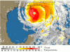
STORM STATUS
September 15, 1:38 PM EDT
Name: Hurricane IvanLocation: About 170 Miles South of The Alabama Coastline.
Lat/Long: 27.8N, 88.2W
Max Winds: 135 mph
Category: 4
Heading: North
Speed: 14 mph
Pressure: 27.73 inches
Hurricane Ivan Intermediate Advisory Number 53a
Issued at: 12:38 PM CDT 9/15/04
Large and dangerous hurricane ivan continues northward toward the gulf coast
A hurricane warning is in effect from grand isle louisiana to apalachicola Florida, including the greater new orleans area and lake pontchartrain. A hurricane warning means that hurricane conditions are expected within the warning area, generally within the next 24 hours. Preparations to protect life and property should be rushed to completion throughout the entire warning area.
A hurricane watch remains in effect from morgan city louisiana to west of grand isle.
A tropical storm warning is in effect from intracoastal city louisiana to west of grand isle, and from east of apalachicola to yankeetown Florida. A tropical storm warning means that tropical storm conditions are expected within the warning area within the next 24 hours.
At 1 pm cdt, 1800z, the center of hurricane ivan was located near latitude 27.8 north, longitude 88.2 west or about 170 miles south of the alabama coastline.
Ivan is moving toward the north near 14 mph, and this motion is expected to continue over the next 24 hours. On the forecast track, the center of ivan is expected to reach the coast during the very early morning hours on Thursday.
Ivan continues as as a extremely dangerous category four hurricane on the saffir/simpson scale hurricane scale, with maximum sustained winds near 135 mph, with higher gusts. Some fluctuations in intensity are possible prior to landfall, but ivan is expected to make landfall as a major hurricane, category three or higher. Occupants of high-rise buildings within the hurricane warning area can expect higher winds than those experienced at the surface, about one saffir-simpson category higher at the top of a 30-story building. After landfall, hurricane force winds could to spread inland up to about 100 miles near the path of the center.
Ivan is a large hurricane, with hurricane force winds extending outward up to 105 miles from the center, and tropical storm force winds extending outward up to 290 miles. The c-man station at southwest pass louisiana has reported sustained winds of 59 mph in the past hour.
The latest pressure measured by a reconnaissance aircraft was 939 mb, 27.73 inches.
Coastal storm surge flooding of 10 to 16 feet above normal tide levels, along with large and dangerous battering waves, can be expected near and to the east of where the center makes landfall. Lesser, but still significant surge values will be experienced where onshore flow occurs west of the center.
Dangerous surf conditions, including rip currents, are likely elsewhere along the Florida gulf coast.
Rainfall accumulations of 10 to 15 inches, with isolated higher amounts, can be expected in association with ivan.
Isolated tornadoes are possible beginning late this afternoon in southern alabama, the Florida panhandle, and southwestern georgia.
Repeating the 1 pm cdt position, 27.8 n, 88.2 w. Movement toward, north near 14 mph. Maximum sustained winds, 135 mph. Minimum central pressure, 939 mb.
For storm information specific to your area, please monitor products issued by your local weather office.
The next advisory will be issued by the national hurricane center at 4 pm cdt.
JonnyK
Active Member
Wanted to inform everyone I'm fine now but the power is shut off. Half of the town don't have power and some do.. So I'm unlucky.
I'm sitting here with my cell phone and typing on the boards. I'm using a tmobile sidekick cell phone with internet.. Aim.. All that goodies so ill keep ya'll an update.
I'm sitting here with my cell phone and typing on the boards. I'm using a tmobile sidekick cell phone with internet.. Aim.. All that goodies so ill keep ya'll an update.
Don't think for a moment you are forgotten! I just took a nap a bit ago but I keep this web page open.
National Data Buoy Center
National Data Buoy Center
Tim G
Well-Known Member
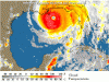
Hurricane Ivan Sends Gulf Coast Residents Fleeing
UPDATED: 5:18 pm EDT September 15, 2004
PERDIDO KEY, Fla. -- Monster waves tugged coastal homes from their foundations Wednesday as Hurricane Ivan churned toward shore, sending residents of the Florida Panhandle fleeing inland to escape the battering winds and large surge of ocean water it threatened to unleash along the Gulf Coast.
Low-lying areas in northwest Florida were under mandatory evacuation orders as the state braced for its third strike in a month by a major hurricane. Officials warned that Ivan, carrying 135 mph winds, would rattle the Panhandle with a dangerous combination of storm surge, intense wind, flooding and tornadoes.
Hurricane warnings stretched from Louisiana to Apalachicola. Forecasters expected the storm to make landfall early Thursday somewhere along a stretch of coastline from Gulfport, Miss., to Pensacola, with coastal areas east of the eye taking a pounding.
"We're very concerned with the storm surge," said Max Mayfield, director of the National Hurricane Center in Miami. He said land east of where the eye of the hurricane passes could face storm surge of 10 to 16 feet, "with some very dangerous breaking waves on top of that."
Four homes built on stilts in the Panhandle coastal community of Cape San Blas were losing their sand foundations and had the potential to be swept away as waves of up to 25 feet landed on the beach, said Larry Wells of Gulf County emergency management. The small peninsula about 35 miles southeast of Panama City is known as a scenic vacation and resort destination with 200 to 300 beachfront homes.
"This is a very serious storm with some significant storm surge," said Lt. Gov. Toni Jennings. "It's deadly out there."
Intermittent rain showers fell Wednesday afternoon and large waves battered a narrow strip of land separating the Gulf of Mexico and Choctawhatchee between Fort Walton Beach and Destin. Water washed over a road at Opal Beach, named after 1995 Hurricane Opal, while waves crashed over the Pensacola Beach fishing pier.
A 15-foot storm surge in Escambia County could breach parts of Pensacola Beach and Navarre Beach, and push water a half-mile inland in Pensacola, said Gary Beeler of the National Weather Service.
In Pensacola, about 2,000 people took shelter at the city's civic center and tried to stay positive before the storm hit. Retired utility worker Richard Everitt brought his fiancee, Sharon Flowers, and her mother, Betty Flowers, who stretched out on a portable bed they had set up on the mezzanine. They passed the time joking about who would get left off the double-bed.
Why do you get yourself upset and get real hyped about it?" Everitt said. "You know it's going to happen."
On Oriole Beach south of Pensacola, Mark Anderson said he was taking his family to stay with his parents in northern Walton County, not far from the Alabama border. Anderson's home is just one block inland from Santa Rosa Sound and about 6 feet above sea-level.
"If it goes, it will float away like an ark," said Anderson, 52, a musician and wood carver who had placed boards of cypress wood rather than plywood over his windows.
Over a breakfast biscuit and a hot cup of coffee, retired Navy Chief Petty Officer Paul Fulmore, 67, said he planned to ride out the storm with his pets at his home three miles from Santa Rosa Sound. But Fulmore said Ivan had everyone's full attention.
"I've seen more people boarding up for this storm than ever before and I've seen more people evacuate and evacuate earlier than I've ever seen before," Fulmore said. "Whether it was hysteria or past experiences people have done more, quicker and earlier."
A steady stream of drivers stopped along U.S. 98 near Fort Walton Beach, several taking pictures of the churning surf. Some predicted Ivan's storm surge would cross the spit of land separating the gulf from the bay.
"This is almost a once-in-a-lifetime view," said Glen Phillips, who has lived in the area since 1967.
At 5 p.m. EDT Wednesday, Ivan was centered about 135 miles south of the Alabama coastline, and moving north at 14 mph. Besides the hurricane warning, a tropical storm warning was in place from east of Apalachicola to Yankeetown.
Forecasters warned of hurricane-force winds, 74 mph or above, up to 105 miles away from the center as it hits land, extending well inland.
Ivan was crashing ashore as Floridians still dealt with destruction across a wide swath of southwest Florida and the central Atlantic coast. Hurricanes Charley and Frances caused billions in damage and were blamed for more than 50 deaths statewide.
Frances was a slow-moving storm that covered much of the peninsula after it struck the state's central Atlantic coast Sept. 5, while Charley was a faster, stronger, more compact storm when it blasted into the state's southwest coast Aug. 13.
About 100,000 homes and businesses in Florida still had no electricity in a relief operation that has distributed nearly 7 million meals, 3 million gallons of water and 20 million pounds of ice.
Following a summer of hurricanes, Republican Senate candidate Mel Martinez urged Congress to devote part of a proposed $2.5 billion Federal Emergency Management Agency hurricane supplemental bill toward zero-interest loans for out-of-pocket insurance deductible costs. High deductibles for damaged homes has been a chief complaint from residents recovering from Charley and Frances.
But more trouble lingered out in the Atlantic. Tropical Storm Jeanne could become a hurricane Wednesday in the Caribbean as it approached Puerto Rico. At 5 p.m., it was about 1,000 miles east-southeast of Miami and long-range forecasts showed it could be near Florida's east coast as early as the weekend.
tigger248
Well-Known Member
My aunt and uncle from Mobile made it here safely. I'm just hoping that my aunt's parents and grandma stay safe. They live about 5 miles from the gulf and her grandma didn't want to leave, so her mom couldn't either (she didn't want to leave her elderly mother!). We're also hoping that they'll have a home to return to.
My thoughts and prayers go out to those who are still down in the path of this monster. Good luck and God bless all of you! Above all, stay safe.
My thoughts and prayers go out to those who are still down in the path of this monster. Good luck and God bless all of you! Above all, stay safe.
Register on WDWMAGIC. This sidebar will go away, and you'll see fewer ads.