Frances Pounds Florida With Wind, Heavy Rains
UPDATED: 4:54 am EDT September 5, 2004
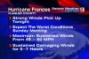
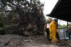
MELBOURNE, Fla. -- Hurricane Frances barged ashore along Florida's east coast early Sunday with sustained winds of 105 mph and pelting rain, knocking out power to 2 million people and forcing Floridians to endure a frightening night amid roaring gales that shredded roofs and uprooted trees.
The National Hurricane Center said the eye of the hurricane officially made landfall near Sewall's Point, just east of Stuart -- about 40 miles north of West Palm Beach -- at about 1 a.m.
Transformers popped along streets, sending sparks into darkened skies, as families huddled in shelters, bathrooms and hotel lobbies. The wind-whipped coastal waters resembled a churning hot tub.
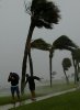
In Melbourne, 65 miles north of Stuart, the wind and rain looked like a giant fire hose going off at full blast.
"I've never seen anything like this, and no one in my family has," said Darlene Munson, who was riding out the storm with family members at her Melbourne restaurant.
The storm's slow-motion assault -- Frances crawled across Florida at just 8 mph -- came more than a day later than predicted. The western portion of the hurricane's eye crept over parts of the east-central Florida coast Saturday night, with its strongest winds hitting early Sunday.
"Those folks are getting pounded, and they've got worse to come," said Max Mayfield, director of the National Hurricane Center.
A hurricane warning remained in effect for nearly 300 miles along Florida's east coast, from Florida City north to Flagler Beach, including Lake Okeechobee.
A continued slow west-northwestward motion was expected to move the entire eye of the hurricane inland by sunrise, the weather service said.
Maximum sustained wind was near 105 mph with higher gusts. There was little chance of strengthening before the eastern half of the eye moved inland, the weather service said.
Hurricane force winds extended up to 85 miles from the center, and tropical storm-force winds, which range from 39 mph to 73 mph, extended up to 200 miles.
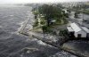
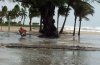
Coastal storm surge flooding of 4 to 6 feet above normal tide levels, along with large and dangerous battering waves, were expected near and to the north of Stuart. Storm surge flooding of 5 feet above normal levels was expected in Lake Okeechobee.
Four people were hospitalized in Boynton Beach after breathing carbon monoxide fumes from a generator that was running in a house. No other injuries were immediately reported.
En route, Frances shattered windows, toppled power lines and flooded neighborhoods in the Bahamas, driving thousands from their homes. The Freeport airport was partially submerged in water.
For many Floridians, this would be a night to remember.
Mary Beth and Jack Stiglin, evacuees from nearby Hutchinson Island, sat in their hotel room in Fort Pierce, eating ham and cheese wraps by candlelight as the power lines outside their room sparked and died.
"It's a little romantic. I brought the roses from our garden because they would have been blown away anyway," Mary Beth Stiglin said.
Frances' arrival came three weeks after Hurricane Charley killed 27 people and caused billions of dollars in damage in southwestern Florida.
For some Floridians, the second storm couldn't arrive soon enough.
"I just want it to be quick. Just get it over with," said Woodeline Jadis, 20, tired of waiting at a shelter in Orlando.
The storm's leading edge pounded the Florida coast early Saturday. Frances was so big that virtually the entire state feared damage from wind and water. Forecasters said the storm would dump 8 to 12 inches of rain, with up to 20 inches in some areas.
"This is the time to show some resolve and not be impatient," Gov. Jeb Bush said. "This is a dangerous, dangerous storm."
In Washington, President Bush declared a major disaster in the counties affected by Frances, meaning residents will be eligible for federal aid.
The largest evacuation in state history, with 2.8 million residents ordered inland, sent 80,000 residents and tourists into shelters. The storm shut down much of Florida, including airports and amusement parks, at the start of the usually busy Labor Day weekend.
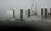
Utility companies said more than 1.3 million customers in Florida were without power early Sunday. Florida Power & Light, the state's largest electric company, said power outages to its customers affected 2 million people. Nearly all of Vero Beach, 31 miles north of Stuart, was blackened. The city's utility said between 95 percent and 100 percent of its 45,000 customers lost power.
In Martin County, where Stuart is located, 630 people taking shelter at a school had to move to another shelter when part of the school's roof blew off, flooding 16 rooms. More than 300 people were able to remain in the school.
Some evacuees, frustrated by Frances' sluggish pace, decided to leave shelters Saturday and return later.
Deborah Nicholas dashed home from a Fort Pierce shelter to take a shower, but stayed only a few minutes when the lights started flickering and trees began popping out of the ground. She has slept in a deck chair at a high school cafeteria since Wednesday.
"I'm going stir crazy," Nicholas said. "I'm going to be in a straitjacket by Monday. I don't know how much longer I can take it. Have mercy."
Residents could take comfort that Frances weakened as it lingered off the coast. Forecasters downgraded it to a Category 2 hurricane as sustained winds receded to 105 mph, down from 145 mph earlier. But the heavy rain forecast still threatened to cause widespread flooding, and the outer bands of the storm packed plenty of punch.
In Palm Bay, winds pried off pieces of a banquet hall roof, striking some cars in the parking lot. Trees were bent and light posts wobbled in the howling gusts.
In Fort Pierce, the storm shredded awnings and blew out business signs. Many downtown streets were crisscrossed with toppled palm trees.
One gust reached 115 mph at Fort Pierce, according to the National Hurricane Center, damaging the mast of a truck measuring the storm's intensity. Florida Power & Light pulled crews off the streets because of heavy wind, meaning those without power would have to wait until the storm subsided, utility spokesman Bill Swank said.
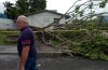
In Stuart, traffic lights dangled, and one hung by a single wire. Downed trees blocked at least one residential street, and signposts were bent to the ground. The facade at a flooring store collapsed, as did the roof of a storage shed at a car dealership.
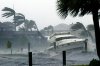
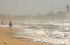
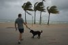
Roads, streets and beaches were mostly deserted -- the occasional surfer notwithstanding. Roads were littered with palm fronds and other debris. Businesses were shuttered and even gas stations were closed, their empty pumps covered with shrink wrap.
Not everyone stayed home: Two men were charged with looting for trying to break into a Brevard County church.
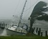
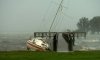
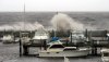
As the weather worsened, a yacht adrift on the Intercoastal Waterway struggled for more than half an hour in choppy water to anchor in West Palm Beach before tying up to a dock. Other boats bobbed like toys. A U.S. Coast Guard helicopter rescued a man and his cat riding out the storm on a sailboat anchored in Biscayne Bay.
At Palm Beach International Airport, the roof and a door were blown off a hangar.
The storm extended vacations for about 10,000 passengers on nine cruise ships unable return to Florida ports on schedule. They were expected to arrive late Sunday or Monday.
Kevin Palmer, a photographer in Palm Beach County, said the wind blew so hard at his front door that it was making the copper weather stripping around it vibrate and shriek violently.
"It's become our high-gust alarm," Palmer said. "It sets the tone for your ambiance when you've got the rumbling outside, you have this screeching from the weather stripping and you keep wondering if that thumping you just heard is another tree going over or a coconut going flying."
Frances was expected to push across the state as a tropical storm just north of Tampa, weaken to a tropical depression and drench the Panhandle on Monday before moving into Alabama.
In the central Atlantic Ocean, the ninth named storm of the season grew stronger Saturday. Tropical Storm Ivan was about 1,355 miles east-southeast of the Lesser Antilles with winds of 70 mph. Forecasters expect Ivan to become a hurricane with winds of at least 74 mph on Sunday and to continue to strengthen.
") . I'm sleeping next to my AC intake with the fan always on to drown out any noises. Still that didn't prevent me from hearing a loud crash just a few minutes ago hehe. Webcam should be showing pix around 7am... http://www.timetrip.net/frances/
. I'm sleeping next to my AC intake with the fan always on to drown out any noises. Still that didn't prevent me from hearing a loud crash just a few minutes ago hehe. Webcam should be showing pix around 7am... http://www.timetrip.net/frances/