
-
Welcome to the WDWMAGIC.COM Forums!
Please take a look around, and feel free to sign up and join the community.
You are using an out of date browser. It may not display this or other websites correctly.
You should upgrade or use an alternative browser.
You should upgrade or use an alternative browser.
The Official Hurricane Jeanne thread
- Thread starter Tim G
- Start date
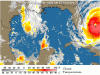
Hurricane Jeanne Update
Nowcast as of 12:30 PM EDT on September 25, 2004
Now!!!
Outer rainbands approaching Martin and St Lucie counties through 2PM, isolated showers will move southwest at 35 mph across Volusia, Lake, Seminole, Orange, Osceola and Brevard counties.
Rainfall accumulations will be less than one tenth of an inch due to the fast movement.
Additional showers, containing heavier rain and gusty winds, associated with the outer rainbands of Hurricane Jeanne, will affect Fort Pierce, Hutchinson Island, port St Lucie, Stuart and Hobe Sound.
Movement is toward the southwest near 60 mph.
The outermost rainband will overspread the Treasure Coast between noon and 1 PM and contain wind gusts near 40 mph.
Then there will be a break followed by the next rainband around mid afternoon which will have the potential to produce heavier rain and stronger wind gusts between 45 and 50 mph along the Martin and St Lucie coasts.
That's bad news Jay...optjay said:WDW just called me to cancel my Hoopdy doo plans for sunday night!
I just saw this on Local6.com.....
Disney Cruise Ships Departing From Port Everglades Because Of Storm
POSTED: 3:40 pm EDT September 24, 2004
Disney Cruise Line announced Friday that its two ships, the Disney Wonder and the Disney Magic, will both depart from Fort Lauderdale’s Port Everglades on Monday, Sept. 27 due to complications created by Hurricane Jeanne.
Disney Cruise Line reservations agents are in the process of contacting guests scheduled to sail on these two cruises to make arrangements for them to arrive in Ft. Lauderdale.
Disney Cruise Line will provide ground transportation for guests between Ft. Lauderdale and Orlando as needed.
Jordan's Mom
New Member
Well, we're leaving in about 10 minutes to drive down to WDW... I am so sick of hurricanes that I'm not going to let this derail our trip. Who knows what will happen? Up until 5 this morning, we (Jax) were supposed to have a direct hit, and now it's going to be just some tropical storm conditions. 
I feel safe at Disney... and I really don't want to go through another week without air conditioning in this house! All Star Movies, here we come!
(I always said I was a Disney Commando. Now I get to prove it! LOL!!)
:wave:
I feel safe at Disney... and I really don't want to go through another week without air conditioning in this house! All Star Movies, here we come!
(I always said I was a Disney Commando. Now I get to prove it! LOL!!)
:wave:
well, I phoned my travel agency this morning, they said me I could report my trip later. So I 'll finally leave from Brussel on thuesday morning, and arrive in Orlando in the evening. I suppose it will be ok at that time. I hope there won't be too damages... By the way, can you tell me if there are still visible traces from previous hurricanes in the Orlando area (just to have an idea) ?
Some damaged billboards, trees down.....that's about it.
Glad to hear you will still be able to make it! :wave:
Glad to hear you will still be able to make it! :wave:
Did you read the Disney announcements in the Hurricane Jeanne Thread??Jordan's Mom said:Well, we're leaving in about 10 minutes to drive down to WDW... I am so sick of hurricanes that I'm not going to let this derail our trip. Who knows what will happen? Up until 5 this morning, we (Jax) were supposed to have a direct hit, and now it's going to be just some tropical storm conditions.
I feel safe at Disney... and I really don't want to go through another week without air conditioning in this house! All Star Movies, here we come!
(I always said I was a Disney Commando. Now I get to prove it! LOL!!)
:wave:
I advice you to read them first before you go...
Jordan's Mom
New Member
Yes, of course I've read it. And I've called Disney twice today. And I've been on the internet for the past week tracking the storm on about 20 different websites. (I do research for a living).
I live 7 blocks from the ocean in an area that will be losing power for at least a week, guaranteed. It's an educated guess as to where I'll be better off.
I live 7 blocks from the ocean in an area that will be losing power for at least a week, guaranteed. It's an educated guess as to where I'll be better off.
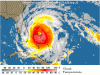
Hurricane Jeanne Update
STORM STATUS September 25, 1:00 PM EDT
Name: Hurricane Jeanne
Location: about 35 miles, 50 km, northeast of freeport grand bahama island. This position is also about 135 miles, 215 km, East of The Southeastern Coast Of Florida.
Lat/Long: 26.8N, 77.9W
Max Winds: 115 mph
Category: 3
Heading: A Little North Of Due West
Speed: 14 mph
Pressure: 28.20 inches
Hurricane Jeanne Intermediate Advisory Number 48a
Issued at: 1:00 PM EDT 9/25/04
Dangerous Hurricane Jeanne Battering The Northwest Bahamas With Fury
A hurricane warning is in effect along the Florida east coast from florida city northward to st. Augustine, including lake okeechobee. A hurricane warning is also in effect for the northwestern bahamas, including the abacos, andros island, berry islands, bimini, eleuthera, grand bahama island, and new providence. Preparations to protect life and property in the hurricane warning area should be rushed to completion.
A tropical storm warning and a hurricane watch remain in effect from north of st. Augustine northward to altamaha sound georgia.
A tropical storm warning is in effect for the west coast of Florida from east cape sable northward to the suwanee river. A hurricane watch is in effect from englewood to the suwanee river.
A tropical storm warning remains in effect for the central bahamas, including cat island, the exumas, long island, rum cay, and san salvador.
A tropical storm watch remains in effect from the suwanne river northward along the west coast of Florida to the ochlockonee river and from south of Florida city around the southern end of the florida peninsula to just south of east cape sable including florida bay, and the Florida keys north of the seven mile bridge.
At 1 pm edt, 1700z, the eye of hurricane jeanne was located near latitude 26.8 north, longitude 77.9 west about 35 miles, 50 km, northeast of freeport grand bahama island. This position is also about 135 miles, 215 km, east of the southeastern coast of florida.
Jeanne is now moving a little north of due west near 14 mph, 22 km/hr. On this track, the core of jeanne will continue near or over the remainder of the northwestern bahamas today, and approach the southeastern coast of Florida tonight or early Sunday. Hurricane force winds are expected to spread inland across much of the Florida peninsula.
Jeanne is dangerous category three hurricane on the saffir/simpson hurricane scale with maximum sustained winds of 115 mph, 185 km/hr, with higher gusts. Some additional strengthening is possible before landfall in Florida. Stronger winds, especially in gusts, are likely to occur on high rise buildings.
Hurricane force winds extend outward up to 70 miles, 110 km, from the center, and tropical storm force winds extend outward up to 205 miles, 335 km, mainly to the north of the center.
Latest minimum central pressure reported by an air force plane was 955 mb, 28.20 inches.
Storm surge flooding of 4 to 8 feet above normal tide levels, along with large and dangerous battering waves, are still occuring near the center of jeanne on the north side of grand bahama island and on the west side of the abaco islands. Storm surge flooding of 2 to 4 feet above normal tide levels can be expected on the west side of the other islands of the bahamas in the hurricane warning area.
Coastal storm surge flooding of 4 to 6 feet above normal tide levels, along with large and dangerous battering waves, can be expected near and to the north of where the center makes landfall along the Florida east coast. A storm surge of up to 7 feet above the present water level is likely to occur mainly on the east side of lake okeechobee.
Tides of 1 to 3 feet above normal are possible in the warned area along the Florida west coast, possible reaching 3 to 6 feet in areas of onshore flow north of tampa bay.
Rainfall totals of 5 to 10 inches, with isolated higher amounts are possible along the track of jeanne over the northwestern bahamas and Florida.
Isolated tornadoes are possible over portions of the east Florida peninsula today.
Repeating the 1 pm edt position, 26.8 n, 77.9 w. Movement toward, a little north of due west near 14 mph. Maximum sustained winds, 115 mph. Minimum central pressure, 955 mb.For storm information specific to your area, please monitor products issued by your local weather office.
An intermediate advisory will be issued by the national hurricane center at 3 pm edt followed by the next complete advisory at 5 pm edt
13,000 are already without power in Palm Beach County....I hope I'm not next.... 
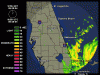
Hurricane Jeanne Update
STORM STATUS September 25, 6:43 PM EDT
Name: Hurricane Jeanne
Location: About 90 Miles East-Southeast of Vero Beach Florida.
Lat/Long: 27.1N, 79.1W
Max Winds: 115 mph
Category: 3
Heading: West To West-Northwest
Speed: 14 mph
Pressure: 28.05 inches
STORM STATUS September 25, 6:43 PM EDT
Name: Hurricane Jeanne
Location: About 90 Miles East-Southeast of Vero Beach Florida.
Lat/Long: 27.1N, 79.1W
Max Winds: 115 mph
Category: 3
Heading: West To West-Northwest
Speed: 14 mph
Pressure: 28.05 inches
Register on WDWMAGIC. This sidebar will go away, and you'll see fewer ads.