Tropical Storm Jeanne Discussion Number 15
Issued at: 4:28 AM EDT 9/17/04
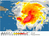
Because the center is inland near the north coast of hispaniola, the reconnaissance plane did not penetrate the eye feature but it made a radar fix instead.
The crew reported that the eye was circular and roughly 15 n mi in diameter. Satellite images after the eclipse suggest that jeanne is not as strong as a few hours ago since the eye feature can not longer be observed and convection has weakened.
This weakening due to interaction with land was anticipated and in fact, it is kind of surprising that jeanne has kept such a well-defined cloud pattern after being over land for a about a day.
Initial intensity has been adjusted down to 55 knots based on a max wind from the recon of 63 knots.
It appears that jeanne will be interacting with hispaniola for 12 more hours and if survives, it could regain hurricane status as indicated in the official forecast. It is good to point out that, historically, not many tropical cyclones survive the path across the high terrain of hispaniola.
The tropical cyclone has been drifting between the west and west-northwest during the past few hours.
A subtropical ridge to the north will likely steer jeanne toward the west-northwest about 5 to 10 knots during the next 24 to 36 hours.
Thereafter, a strong trough located over the eastern united states and partially associated with ivan, will force jeanne to move toward the northwest or even north-northwest. In 4 or 5 days, the track forecast becomes highly uncertain. Most of the global models indicate that the trough will become replaced by a rather strong high pressure system which eventually would force jeanne westward.
This is basically the solution unanimously provided by the dynamical models and it is indicated in the official forecast.
It is too early to mention what portion of the southeast u.s. Coast may be threatened but long range guidance suggests a high risk all the way from Florida to the carolinas.
Forecast positions and max winds
Initial 17/0900z 19.5n 70.1w 55 kt 12hr vt 17/1800z 20.0n 70.9w 55 kt 24hr vt 18/0600z 21.3n 72.5w 65 kt 36hr vt 18/1800z 23.0n 74.0w 70 kt 48hr vt 19/0600z 25.0n 75.0w 75 kt 72hr vt 20/0600z 27.0n 76.0w 80 kt 96hr vt 21/0600z 28.5n 77.0w 85 kt 120hr vt 22/0600z 29.5n 80.0w 85 kt
Issued at: 4:28 AM EDT 9/17/04
Because the center is inland near the north coast of hispaniola, the reconnaissance plane did not penetrate the eye feature but it made a radar fix instead.
The crew reported that the eye was circular and roughly 15 n mi in diameter. Satellite images after the eclipse suggest that jeanne is not as strong as a few hours ago since the eye feature can not longer be observed and convection has weakened.
This weakening due to interaction with land was anticipated and in fact, it is kind of surprising that jeanne has kept such a well-defined cloud pattern after being over land for a about a day.
Initial intensity has been adjusted down to 55 knots based on a max wind from the recon of 63 knots.
It appears that jeanne will be interacting with hispaniola for 12 more hours and if survives, it could regain hurricane status as indicated in the official forecast. It is good to point out that, historically, not many tropical cyclones survive the path across the high terrain of hispaniola.
The tropical cyclone has been drifting between the west and west-northwest during the past few hours.
A subtropical ridge to the north will likely steer jeanne toward the west-northwest about 5 to 10 knots during the next 24 to 36 hours.
Thereafter, a strong trough located over the eastern united states and partially associated with ivan, will force jeanne to move toward the northwest or even north-northwest. In 4 or 5 days, the track forecast becomes highly uncertain. Most of the global models indicate that the trough will become replaced by a rather strong high pressure system which eventually would force jeanne westward.
This is basically the solution unanimously provided by the dynamical models and it is indicated in the official forecast.
It is too early to mention what portion of the southeast u.s. Coast may be threatened but long range guidance suggests a high risk all the way from Florida to the carolinas.
Forecast positions and max winds
Initial 17/0900z 19.5n 70.1w 55 kt 12hr vt 17/1800z 20.0n 70.9w 55 kt 24hr vt 18/0600z 21.3n 72.5w 65 kt 36hr vt 18/1800z 23.0n 74.0w 70 kt 48hr vt 19/0600z 25.0n 75.0w 75 kt 72hr vt 20/0600z 27.0n 76.0w 80 kt 96hr vt 21/0600z 28.5n 77.0w 85 kt 120hr vt 22/0600z 29.5n 80.0w 85 kt
")