The Official Hurricane Ivan thread...

Tim G

Well-Known Member
Hurricane Ivan Advisory Number 57

Issued at: 9:30 AM CDT 9/16/04


Ivan moving northward across western alabama and weakening


At 10 cdt, 1500z, the hurricane warning has been changed to a tropical storm warning from the mouth of the pearl river to apalachicola Florida. All coastal warnings are discontinued elsewhere.

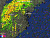
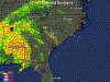
At 10 am cdt, 1500z, the center of hurricane ivan was located near latitude 32.0 north, longitude 87.5 west or about 65 miles west-southwest of montgomery alabama.

Ivan is moving toward the north near 14 mph. A gradual turn toward the northeast and a decrease in forward speed are expected during the next 24 hours. This motion should bring the center across central alabama today and into northeastern alabama tonight.

Maximum sustained winds have decreased to near 75 mph, with higher gusts. Additional weakening is forecast during the next 24 hours, and ivan will likely weaken to a tropical storm this afternoon.

Hurricane force winds extend outward up to 50 miles from the center, and tropical storm force winds extend outward up to 290 miles, mainly to the southeast of the center. The emergency operations center in demopolis alabama recently reported sustained winds of 72 mph.

Estimated minimum central pressure is 970 mb, 28.64 inches.
Coastal storm surge flooding will be diminishing today.
Dangerous surf conditions, including rip currents, are likely elsewhere along the Florida gulf coast.

Maximum rainfall accumulations of 10 to 15 inches, with locally higher amounts over the southern appalachians, can be expected in association with ivan through Saturday.
Tornadoes are possible over the next 24 hours in eastern alabama, the Florida panhandle, western georgia, eastern tennessee, western south carolina, and western north carolina.

Repeating the 10 am cdt position, 32.0 n, 87.5 w. Movement toward, north near 14 mph. Maximum sustained winds, 75 mph. Minimum central pressure, 970 mb.

For storm information specific to your area, please monitor products issued by your local weather office.
An intermediate advisory will be issued by the national hurricane center at 1 pm cdt followed by the next complete advisory at 4 pm cdt.
 

Tim G

Well-Known Member
Update Hurricane Ivan

South East Doppler Radar

Image = RealTime
 

Attachments

  • Southeast_anim.gif
    Southeast_anim.gif
    362.7 KB · Views: 133

Ringo8n24

Active Member
Hey, guys. No power here at my home in Gulfport at this time. A strong gust came up about 11 pm last night and took out a tree which fell on our power lines, thankfully not on our house. I heard that I-10 Pensacola Bay bridge collapsed westbound and eastbound is now closed due to being unsafe. Has anyone else heard that? If that is true, we may have to fly on Saturday to WDW instead of driving. I am ready to go.
 

TURKEY

New Member
Ringo8n24 said:
Hey, guys. No power here at my home in Gulfport at this time. A strong gust came up about 11 pm last night and took out a tree which fell on our power lines, thankfully not on our house. I heard that I-10 Pensacola Bay bridge collapsed westbound and eastbound is now closed due to being unsafe. Has anyone else heard that? If that is true, we may have to fly on Saturday to WDW instead of driving. I am ready to go.
Start finding an alternate route or buying tickets.

http://www.orlandosentinel.com/news/weather/orl-bk-ivan091604,1,3067505.story?coll=orl-home-promo

Says Westbound was damaged, Eastbound about 1/4 mile washed away.
 

disneymoc

Active Member
The eye is supposed to pass over us late tonight and early tomorrow morning. I'll be battoning down the hatches and swimming to work in the morning it looks like.
 

pinkrose

Well-Known Member
We're in the middle waiting for round two. Not going to be near as bad though. Haven't had power since this moring and it's a mess outside. Winds were in the 70's. I hope that everyone on the gulf coast is ok.
 

SpongeScott

Well-Known Member
The eye is now about 15 miles south of us. Winds have been around 40-50 mph off and on. Last time I checked, we had 2-3 inches of rain. Neighbors lost a tree, but haven't seen any other damage. Flooding is occuring in other parts of Huntsville.

Elizabeth, do you all have school tomorrow?
 

tigger248

Well-Known Member
Good to hear from those of you who have been able to check in. I hope everyone else is okay.

My aunt's parents and grandmother in Mobile are okay. My aunt talked to them this morning, they have no power, but they do have phone lines. It sounds like Mobil got lucky compared to Pensacola. They'll hopefully know if their house is okay tomorrow (her dad was planning to drive by it).

My thoughts and prayers go out to all of you directly affected by Ivan. I hope everyone stays safe and that all is well.

The remnants are in my area now. All we're getting is the rain and it's mostly east of Louisville. I do only live a couple miles from the river though so it's good that it's mostly east of here.

EDIT: I just read on my local news web page that 22 people have died in the US from Ivan. Very sad news and there's possibly more out there that haven't been found yet.
 

pinkrose

Well-Known Member
SpongeScott said:
The eye is now about 15 miles south of us. Winds have been around 40-50 mph off and on. Last time I checked, we had 2-3 inches of rain. Neighbors lost a tree, but haven't seen any other damage. Flooding is occuring in other parts of Huntsville.

Elizabeth, do you all have school tomorrow?

Sorry I'm so long in answering. I'm on battery and only stayed on for a min last night. I'm still on battery. No power. :(

No, we don't have school today. The announced on Wed. no school for Thursday or Friday. I'm anxious to get out and see how things look. We went out walking with a neighbor yesterday evening and couldn't believe how the trees were snapped at the bases. We have had a bad mudslide (2 of them) on Highway 31 near Brookwood hospital. For a while, they were thinking that one of the dams was going to break. So much flooding. We were lucky. No damage to the house (besides my carpet). The wind here was so strong that it got the carpet near my back door SOAKED. It wasn't flood, just wind blowing that hard. Even with weather stripping. I believe we had gust of about 70 mph. I heard alot of 60 plus mph's around here. It was pretty loud. Sounded like a train going through. I called the power company to report it and the recording said " Your power will be restored by 11:30 am :sohappy: on Sept 20 :eek: I do hope it's before then. Thank goodness when we built the house, my dad talked me into having a gas stove installed. That came in handy. I was able to cook a roast for dinner and have my neighbor and her daughter over for dinner.

How did you all do up there Scott? I haven't been able to watch. I do have a battery powered radio that we've been listening to, but haven't heard the damage reports up there. Are schools out yup there?

I feel so bad for those down near the coast :(
 

Tim G

Well-Known Member
Storm Ivan Kills At Least 23
Rain Still Pounding South

Damage Estimates Between $3 Billion, $10 Billion

UPDATED: 08:33 AM EDT September 17, 2004


The death toll from Hurricane Ivan continues to climb, with at least 23 known fatalities.
Most of those killed were in Florida, where at least 14 are known dead. Authorities in Mississippi and Georgia both report two deaths each. In Louisiana, four evacuees died. One person died in Alabama.
Officials estimate the damage from the storm will total between $3 billion and $10 billion.

While Ivan's center swerved into the coast just east of Mobile, Ala., the most violent winds in its northeast quadrant tore through the Florida Panhandle.
Ivan spun off at least a dozen tornadoes in Florida, while creating a storm surge of 10 to 16 feet, topped by large battering waves. A portion of a bridge on Interstate 10 was washed away.
What's left of Ivan has generated torrential rain and tornadoes in northern Georgia and drenched southeastern Tennessee.
High winds have brought down trees and power lines -- leaving thousands without power.

Forecasters are expecting Ivan, now a tropical storm, to continue on a northeastward path across the South, weakening to a tropical depression overnight. Areas already soggy from Hurricanes Charley and Frances could get up to 15 more inches of rain.

At 10 p.m. CDT, Ivan's center was located near latitude 34.3 north, longitude 86.2 west, or about 25 miles north-northwest of Gadsden, Ala. It's moving north-northeast at about 14 mph and is expected to slow its speed during the next 24 hours.
The center of Ivan continues to march northeastward through Alabama.
Winds have diminished to about 60 mph, and additional weakening is expected in the next 24 hours as Ivan moves further inland.

Forecasters also say tornadoes are possible Friday in eastern Alabama, northern and central Georgia, eastern Tennessee, South Carolina, and western North Carolina.
While most of the deaths were in Florida, a Mississippi man died in Ivan's aftermath. The state's governor said a man was trying to fix an antenna that had fallen during the strong winds. He was killed when a live electrical wire hit the antenna.
Four ailing evacuees -- a terminally ill cancer patient, two nursing home patients and a homebound patient -- in Louisiana died after being taken from their storm-threatened homes to safer parts of the state.

On Thursday morning, at least 260,000 homes and businesses were without power in Alabama, 36,500 were without power in Louisiana, and 70,000 were affected in Mississippi. More than 300,000 customers were without power in the four westernmost Florida Panhandle counties. Florida was still trying to restore power to about 160,000 hit by Hurricanes Charley and Frances in recent weeks.

In Mississippi, the governor says power may not be restored until Friday. In Alabama, some seaside communities remain closed due to dangers of downed power lines and weakened buildings.
But many of the millions of Gulf Coast residents who spent a frightening night in shelters and boarded-up homes emerged Thursday to find that Ivan was not the catastrophe they had feared.
Residents are reporting downed trees and damaged roofs, but overall, they say, they "came out pretty good."
"The good Lord was looking out for us," said one resident, who went room to room with his family as the winds shifted Wednesday night.
The police chief in Mobile, Ala., said Hurricane Ivan was not as bad as Hurricane Frederic, which devastated the Alabama coast in 1979.

The storm knocked out power to thousands of homes and businesses in the Mobile area, and forecasters say Ivan could still dump inches of rain on areas, causing massive flooding.
But Mobile Police Chief Sam Cochran said, all things considered, they "were really spared and blessed."

Towns to the east of where the eye of Hurricane Ivan made landfall are seeing equal amounts of destruction.
The town of Josephine, Ala., is just northeast of where Ivan came ashore.
Residents are faced with cleaning up front porches ripped from trailers, downed power lines blocking roads and dozens of uprooted trees. Flooding has also left mailboxes floating and downed power lines in water.
One resident who rode out the storm said the town now resembles a "a war zone."
President George W. Bush signed disaster declarations Thursday for Alabama, Louisiana and Mississippi, and was awaiting paperwork from Florida.

In Florida, two people were killed and more than 200 homes were damaged when at least five tornadoes roared through Florida's Bay County. Five people were killed when another tornado struck homes in Blountstown, Fla., and an 8-year-old girl died after being crushed by a tree that fell onto her mobile home in Milton, Fla. Her parents were unharmed.
Max Mayfield, the director of the National Hurricane Center in Miami, warned that the misery would spread as Ivan moves across the Southeast in the hours and days ahead. "I hate to think about what's going to happen inland," he said.

The storm's northward track spared New Orleans a direct hit.
Parts of the city particularly vulnerable because much of it is below sea level saw only sporadic, light rain overnight, though wind gusts reached tropical storm strength.
The city suffered some downed tree limbs that knocked out power to 30,000 homes and businesses. But other than that, New Orleans was pretty much unscathed.
Fears of strong winds and massive flooding drove thousands of residents out. But in the end, officials said the city got only two-tenths of an inch of rain.
St. Charles Avenue, which runs through the heart of city, is not even wet.
The city has been fortunate to have missed some other big storms in the past, including one in 1998 and Hurricane Lily two years ago.
Still, the recent storm did some damage economically. The chef at one restaurant figures the place lost $100,000 in missed business.
 

Tim G

Well-Known Member
Tropical Depression Ivan Advisory Number 59

Ivan weakens into a tropical depression, Heavy rainfall and flooding still a major concern.

At 10 pm cdt, 0300z, the center of tropical depression ivan was located near latitude 34.3 north, longitude 86.2 west or about 25 miles north-northwest of gadsden alabama.

The depression is moving toward the north-northeast near 14 mph. A gradual turn to the northeast at a slower forward speed is expected during the next 24 hours. This motion should bring the center of ivan across northeastern alabama tonight and into northwestern georgia or southeastern tennessee early Friday.

Maximum sustained winds are near 35 mph, 55 km/hr, with higher gusts. Additional weakening is forecast during the next 24 hours as ivan moves farther inland.

The estimated minimum central pressure is 986 mb, 29.12 inches.
Maximum rainfall accumulations of 8 to 12 inches, with locally higher amounts over the southern appalachians, can be expected in association with ivan through Saturday.

Tornadoes are possible over the next 24 hours in eastern georgia, south carolina, and extreme western north carolina.
Repeating the 10 pm cdt position, 34.3 n, 86.2 w. Movement toward, north-northeast near 14 mph. Maximum sustained winds, 35 mph. Minimum central pressure, 986 mb.

This is the last public advisory issued by the national hurricane center on Ivan. Future information on this system can be found in public advisories issued by the hydrometeorological prediction center, under awips header tcpat4 and wmo header wtnt34 kwnh, beginning at 4 am cdt, Friday morning.
 

SpongeScott

Well-Known Member
Not too bad here--some localized flooding. I'm going to get pictures of the neighbor's tree and post a little later. School for Madison County and Huntsville City were open today. My kids were not happy. Oh (and I hate to mention this), we never lost power.
 

disneymoc

Active Member
I wanted to let you know that we made it through the night. Man were those winds blowing. We're not supposed to have a Tropical Storm in TENNESSEE.


Anyway, there was a tree down across the street this morning. And our pool was overflowing -- might have some erosion issues when it is all over.

But overall, we are fine. Didn't lose power or anything.
 

Tim G

Well-Known Member
Update Hurricane Ivan

Mid Atlantic Doppler Radar

Image = RealTime
 

Attachments

  • Mid Atlantic_anim.gif
    Mid Atlantic_anim.gif
    381.4 KB · Views: 133

MKCP 1985

Well-Known Member
Just checking in to say we made it back to the homestead and all is well. Family in Mobile say they lost power for a few hours, but no property loss.

We learned that evacuation from south Mississippi is a logistical nightmare. There is only one major road running north, and it intersects with an interstate highway (I-59) roughly 70 miles north of the coast. With everyone evacuating, it took 6 hours to cover that 70 miles. Ivan was moving faster than we were!

Condolences to Pensacola and the rest of the Florida Panhandle. :(
 

Register on WDWMAGIC. This sidebar will go away, and you'll see fewer ads.

Back
Top Bottom