The Official Hurricane Ivan thread...

Ringo8n24

Active Member
I have a feeling that WDW will be spared from this one, but we will not here. Now I have to figure out how to cross Ivan via I-10 to get to WDW. I heard that last week I-10 was closed from Mobile, AL to Tallahassee. Everyone is telling me to reschedule, but I have been looking forward to this trip for months. :confused:
 

SpongeScott

Well-Known Member
Well, maybe Florida is catching a much-deserved break on Ivan. Looks like the Gulf Coast is in for a hit, then up the gut to North Alabama to see me. Heck, I don't even want to mess with it after it gets 300 miles inland.
 

pinkrose

Well-Known Member
SpongeScott said:
Well, maybe Florida is catching a much-deserved break on Ivan. Looks like the Gulf Coast is in for a hit, then up the gut to North Alabama to see me. Heck, I don't even want to mess with it after it gets 300 miles inland.

Yup, looks like he'll visit me in central Alabama as well.
 

pinkrose

Well-Known Member
Ringo8n24 said:
I have a feeling that WDW will be spared from this one, but we will not here. Now I have to figure out how to cross Ivan via I-10 to get to WDW. I heard that last week I-10 was closed from Mobile, AL to Tallahassee. Everyone is telling me to reschedule, but I have been looking forward to this trip for months. :confused:

Perhaps go up, across Alabama, to Atlanta. Head south from there. It will be longer though. Someone else may have a better way.
 

Tim G

Well-Known Member
<TABLE borderColor=#000000 cellSpacing=0 cellPadding=2 width="98%" border=1><TBODY><TR><TD bgColor=#ff0000><TABLE width="100%"><TBODY><TR><TD class=large>STORM STATUS</TD><TD class=small align=right>September 12, 7:40 AM EDT</TD></TR></TBODY></TABLE></TD></TR><TR><TD bgColor=#cccccc><TABLE cellSpacing=0 cellPadding=2 width="95%" border=0><TBODY><TR><TD colSpan=2>Name: Hurricane Ivan</TD></TR><TR><TD class=small vAlign=top>Location: About 35 miles, 55 km, South of Grand Cayman.
Lat/Long: 18.8N, 81.2W
Max Winds: 155 mph
Category: 4
</TD><TD class=small vAlign=top noWrap>Heading: West-Northwest
Speed: 9 mph
Pressure: 27.14 inches
</TD></TR></TBODY></TABLE></TD></TR></TBODY></TABLE>
Hurricane Ivan Intermediate Advisory Number 40a

Issued at: 7:40 AM EDT 9/12/04

Dangerous hurricane ivan threatens grand cayman

A hurricane warning remains in effect for the cayman islands.

A hurricane warning remains in effect for cuba from pinar del rio to ciego de avila including the isle of youth. A hurricane warning means that hurricane conditions are expected within the warning area within the next 24 hours. Preparations to protect life and property should be rushed to completion.

A hurricane watch remains in effect for the rest of cuba. A hurricane watch means that hurricane conditions are possible within the watch area, generally within 36 hours.

A tropical storm warning remains in effect for jamaica, but will likely be lowered later this morning.
Interests in the northwestern caribbean sea, as well as in the eastern gulf of mexico, should closely monitor the progress of this extremely dangerous hurricane.

At 8 am edt, 1200z, the center of hurricane ivan was located near latitude 18.8 north, longitude 81.2 west or about 35 miles, 55 km, south of grand cayman.
Ivan is moving toward the west-northwest near 9 mph, 15 km/hr, and a turn toward the northwest is expected during the next 24 hours. On this track, the center of the hurricane will move over, or very near, grand cayman by this afternoon.

Maximum sustained winds are near 155 mph, 250 km/hr, with higher gusts.
This is category four on the saffir-simpson hurricane scale. Some fluctuations in intensity are likely during the next 24 hours and ivan could regain category five intensity.
Hurricane force winds extend outward up to 90 miles, 150 km, from the center, and tropical storm force winds extend outward up to 175 miles, 280 km.

Estimated minimum central pressure is 919 mb, 27.14 inches.
Storm surge flooding of 5 to 8 feet above normal tide levels, along with large and dangerous battering waves, can be expected in portions of the cayman islands, depending on the exact track of ivan.
Coastal storm surge flooding of 20 to 25 feet, locally higher, above normal tide levels, along with large and dangerous battering waves, can be expected near and to the east of where the center makes landfall in cuba.

Rainfall amounts of 8 to 12 inches, possibly causing life- threatening flash floods and mud slides, can be expected along the path of ivan.
Repeating the 8 am edt position, 18.8 n, 81.2 w. movement toward, west-northwest near 9 mph.
Maximum sustained winds, 155 mph.
Minimum central pressure, 919 mb.

For storm information specific to your area, please monitor products issued by your local weather office.
The next advisory will be issued by the national hurricane center at 11 am edt.
 

Tim G

Well-Known Member
Update Hurricane Ivan

Ivan Charts Course That Should Spare Central Florida

UPDATED: 8:15 am EDT September 12, 2004


KEY WEST, Fla. -- Streets, bars, hotels and shops in this normally bustling island resort town were mostly empty Sunday, even as officials in the Florida Keys said they were "cautiously optimistic" Hurricane Ivan might spare the island chain its worst punishment.
Ivan has killed 56 people across the Caribbean so far, including 34 in Grenada and 11 in Jamaica.
Millions more people are in its path, with the powerful Category 4 storm projected to go between the Cayman Islands, make a direct hit on Cuba and then either move into the Gulf of Mexico or South Florida on Monday. Mandatory evacuation orders for tourists and 79,000 residents were in effect for the Keys.

The storm initially was projected to hit the Keys directly, but it unexpectedly wobbled and lurched west early Saturday, bringing hope to weary Floridians who already have suffered through two other hurricanes in less than a month.
"From a psychological standpoint, it feels better, but from a meteorological standpoint we're not out of the woods yet," said Matt Strahan, a National Weather Service meteorologist in Key West.

Billy Wagner, senior director of Monroe County Emergency Management, said he was "cautiously optimistic" about the forecasts, but officials said they had no plans to ease protective measures.
Some residents remained unsure whether to leave. Eddie Mathis, who lives on a sailboat, said he probably would stay onboard.
"If we did get hit by a solid Category 5, there's going to be not many boats around here that's going to be left -- I don't think it's going to be that bad," he said.
Resident Sofia Artola, 37, said there was no point in moving short distances to avoid the storm.
"If you don't leave Florida, there's no point of leaving at all. We just kind of ride it out and say we'll just see what happens," Artola said. "We go through this every year and even though it's a pretty good storm, whatever happens, happens."

At 5 a.m., Ivan was centered about 55 miles south-southeast of Grand Cayman and was moving west-northwest at 9 mph. It was expected to stay on that course through Sunday.
The National Hurricane Center in Miami said late Saturday that Ivan had the sixth lowest central pressure ever recorded for a storm in the Atlantic basis -- an important measure of the storm's strength.
Only Camille in 1969, Mitch in 1998, Allen in 1980, the Labor Day storm in 1935 and Gilbert in 1988 had lower central pressures.
Those who evacuated the Keys made the "right decision" because hurricane-force winds and rain could still affect the island chain, said Max Mayfield, the center's director. He said people shouldn't let their guards down.

The deadly storm smashed into Jamaica early Saturday with ferocious waves and wind nearing 155 mph. It strengthened to a Category 5 storm with 165 mph sustained winds later in the day but dropped back to 155 mph early Sunday, making it a Category 4 storm. However, forecasters warned Ivan could regain strength by Monday as it moved across warm tropical seas toward Cuba.

State officials, still manning round-the-clock operations since hurricanes Charley and Frances struck in the last month, prepared for a potential strike on the Keys.
They made plans to reach storm victims by air and by sea, and to deliver supplies in the event that any of the bridges connecting the islands to the mainland become impassable.
Officials said some operations helping in the recovery from hurricanes Charley and Frances were being shifted or temporarily suspended, but stressed that support for victims of those storms would continue as Ivan approached.
"Sometimes I wish that these things wouldn't all happen in our state all at once, but if there was a place that could rebound from this, it's Florida," Gov. Jeb Bush said.

About 473,100 homes and businesses still lacked power Saturday on Florida's east coast, where Frances struck on Sept. 5. Many Palm Beach County residents also faced such nuisances as overflowing sewers.
 

Tim G

Well-Known Member
Update Hurricane Ivan

Atlantic I.R. Satellite Update

Image Delay = 30 Mins.
 

Attachments

  • Ivan at_ir_loop_13.gif
    Ivan at_ir_loop_13.gif
    512.9 KB · Views: 143

Tim G

Well-Known Member
Update Hurricane Ivan

Caribbean I.R. Satellite Update

Image Delay = 30 mins.
 

Attachments

  • jam_ir_anim08.gif
    jam_ir_anim08.gif
    518.5 KB · Views: 139

Tim G

Well-Known Member
Ivan grows, aims for Cuba

Death Toll Climbs As Panhandle Worries

September 12, 2004, 8:07 AM EDT


MIAMI -- Hurricane Ivan killed at least 11 people in Jamaica on Saturday before taking a more westerly track that might spare the Florida Keys and save Central Florida and the southwest coast from another lashing.
Packing 155-mph winds, Ivan was still on track to barrel over the Cayman Islands and thrash western Cuba on Monday with a 20- to 25-foot storm surge and as much as 12 inches of rain. At 8 a.m. today, the storm was 35 miles south of Grand Cayman, moving at 9 mph west-northwest.

After that, it was expected to take aim at Florida's northern Gulf Coast, possibly the Panhandle -- perhaps as a lesser but still-mighty Category 3 storm later in the week.
"The threat to the southeast peninsula has decreased, but the eventual threat north, particularly to the Panhandle, has increased," said Ed Rappaport, deputy director of the National Hurricane Center west of Miami. "For some people in Florida this is good news; for others it's not."

After thrashing Jamaica, Ivan ballooned Saturday into a top-of-the-chart Category 5 storm with the sixth-lowest barometric pressure ever recorded in the Atlantic Basin. If Ivan stays on its current track -- which is a big if, given the average 200-mile error in the official three-day forecast -- it would be about 180 miles west of Florida's southwest coast Tuesday.

Earlier, Ivan's eye spun slightly to the west and nudged along Jamaica's southern coastline, sparing the island the worst of its 155-mph fury. Still, 25-foot waves and torrential rains crushed homes, uprooted trees and killed at least 11 people.
The slight wobble also delayed Ivan's anticipated turn to the north, which was good news for hurricane-fatigued Floridians, at least in South Florida. Forecasters said the Florida Keys, where residents were still evacuating Saturday, might escape hurricane-force winds.

They were considering posting tropical-storm watches or warnings for the Florida Keys today, which means the fragile island chain could feel winds of more than 39 mph -- far less than the 135-mph winds projected a few days ago.

Emergency officials, however, had no regrets about ordering a complete evacuation of the Keys' 79,000 residents. As state meteorologist Tim Nelson said, "We often see erratic movements and wobbles with these hurricanes, especially when they're intense hurricanes. There still is a high risk for every part of our coast right now."

And as the risk for the Panhandle grew, Gov. Jeb Bush said he had all but lost hope that the state would be spared a strike from its third hurricane in less than a month. Hurricane Charley devastated Charlotte County on Aug. 13, and Hurricane Frances raked the east Central Florida coast last week.
"We pray for the best and prepare for the worst," Bush said. "And it appears the preparations will be necessary."
As he spoke, Tallahasseeans swarmed supermarkets and home stores Saturday, bracing for what could be the city's worst storm in almost 20 years. In 1985, Hurricane Kate downed many of the city's renowned live oaks and left thousands without power for as much as two weeks.

"I went through Hurricane Andrew in South Florida, and I know we're going to get nailed," said Mike Taylor, 41, a roofing manufacturer from nearby Bradfordville, pushing a cartload of plywood out of a Home Depot. "Everything I see on this storm looks like it's dialing in right here."
Kelley Hays, 20, a Home Depot cashier on the city's densely populated north side, said the store received 1,000 sheets of plywood Saturday afternoon -- and two hours later was almost sold out."The phones have been ringing off the hook," Hays said. "People calling about plywood and generators. We've got 8,000 more plywood sheets coming in later."

Lisa Simpson, 40, a Tallahassee accountant, loaded up on $300 worth of supplies, including plywood and a handsaw.
"We missed Charley and most of Frances," she said of Florida's earlier hurricanes. "But I'm afraid this one's going to come here."

In Charlotte County, which was dead center in Ivan's projected path Friday, officials began a mandatory evacuation Saturday for those living on barrier islands, in mobile homes and in special-needs facilities, such as nursing homes.
Though the hurricane center's official forecast track placed Ivan about 180 miles west of Southwest Florida on Tuesday, just out of reach of Ivan's tropical-storm-force winds, Charlotte officials were taking no chances.

If they learned anything from Charley, which was predicted to hit farther north in Tampa Bay, it was not to concentrate on the official forecast track, but the much larger cone of potential landfall around it. Saturday night, Florida's entire west coast was still very much in that cone. And even Frances, which sloshed ashore on the opposite coast, left already-battered Punta Gorda with severe flooding.

More than 1,200 displaced residents of Charlotte County were evacuated Saturday to shelters. More than 80 people with special medical needs may be airlifted today to Orlando, where a shelter with space for several thousand people is being set up at the Orange County Convention Center.
 

Tim G

Well-Known Member
A Lot Of Damage On Jamaica
 

Attachments

  • Church.jpg
    Church.jpg
    39.4 KB · Views: 135
  • crack.jpg
    crack.jpg
    33.2 KB · Views: 140
  • Easly7.jpg
    Easly7.jpg
    30.3 KB · Views: 136
  • matras.jpg
    matras.jpg
    36.9 KB · Views: 141

nikimsu2002

New Member
NemoRocks78 said:
I'm just glad that this one isn't coming here....if it was, we were going to get on a flight to Boston. Frances was enough.

Thanks to Frances, school is out until September 20th for me..... :D

You must go to school near where my friend goes. She told me the other day she doesn't have school until then either.

I hope everyone stays safe wherever this thing heads.
 

Tim G

Well-Known Member
<TABLE borderColor=#000000 cellSpacing=0 cellPadding=2 width="98%" border=1><TBODY><TR><TD bgColor=#ff0000><TABLE width="100%"><TBODY><TR><TD class=large>STORM STATUS</TD><TD class=small align=right>September 12, 1:56 PM EDT</TD></TR></TBODY></TABLE></TD></TR><TR><TD bgColor=#cccccc><TABLE cellSpacing=0 cellPadding=2 width="95%" border=0><TBODY><TR><TD colSpan=2>Name: Hurricane Ivan</TD></TR><TR><TD class=small vAlign=top>Location: About 60 miles, 95 km, West of Grand Cayman.
Lat/Long: 19.2N, 82.1W
Max Winds: 150 mph
Category: 4
</TD><TD class=small vAlign=top noWrap>Heading: West-Northwest
Speed: 10 mph
Pressure: 27.23 inches
</TD></TR></TBODY></TABLE></TD></TR></TBODY></TABLE>
Hurricane Ivan Intermediate Advisory Number 41a

Issued at: 1:56 PM EDT 9/12/04


Dangerous hurricane Ivan lashes Grand Cayman

A hurricane warning is in effect for the cayman islands.

A hurricane warning is in effect for cuba from pinar del rio to ciego de avila including the isle of youth. A hurricane warning means that hurricane conditions are expected within the warning area within the next 24 hours. Preparations to protect life and property should be rushed to completion.

A hurricane watch is in effect for the rest of cuba. A hurricane watch means that hurricane conditions are possible within the watch area, generally within 36 hours.

A tropical storm watch is in effect for the Florida keys from the seven mile bridge westward to the dry tortugas.
Interests in the northwestern caribbean sea, as well as in the eastern gulf of mexico, should closely monitor the progress of this extremely dangerous hurricane.

At 2 pm edt, 1800z, the center of hurricane ivan was located near latitude 19.2 north, longitude 82.1 west or about 60 miles, 95 km, west of grand cayman.
Ivan is moving toward the west-northwest near 10 mph, 17 km/hr, and a turn toward the northwest is expected during the next 12 to 24 hours.
On this track, the center of the hurricane is expected to pass near or over the western end of cuba Monday afternoon or evening.

Maximum sustained winds are near 150 mph, 240 km/hr, with higher gusts. This makes ivan a strong category four on the saffir-simpson hurricane scale. Some fluctuations in intensity are likely during the next 24 hours and ivan could regain category five intensity.

Hurricane force winds extend outward up to 90 miles, 150 km, from the center, and tropical storm force winds extend outward up to 175 miles, 280 km.
The estimated minimum central pressure is 922 mb, 27.20 inches.
Storm surge flooding of 5 to 8 feet above normal tide levels, along with large and dangerous battering waves, can be expected in portions of the cayman islands, depending on the exact track of Ivan.
Coastal storm surge flooding of 20 to 25 feet, locally higher, above normal tide levels, along with large and dangerous battering waves, can be expected near and to the east of where the center makes landfall in cuba.
Reports from ham radio operators and the cayman meteorological service indicate that power is out throughout the island, numerous buildings have lost their roofs, water up to 2 feet deep covers the airport runway, and water as high as 5 feet is flowing through many homes.

Rainfall amounts of 8 to 12 inches, possibly causing life- threatening flash floods and mud slides, can be expected along the path of Ivan.
Repeating the 2 pm edt position, 19.2 n, 82.1 w. Movement toward, west-northwest near 10 mph. Maximum sustained winds, 150 mph. Minimum central pressure, 922 mb.

For storm information specific to your area, please monitor products issued by your local weather office.
The next advisory will be issued by the national hurricane center at 5 pm edt.
 

Tim G

Well-Known Member
Update Hurricane Ivan

Atlantic I.R. Satellite Update

Image Delay = 30 Mins.
 

Attachments

  • Ivan at_ir_loop_14.gif
    Ivan at_ir_loop_14.gif
    557.4 KB · Views: 110

Tim G

Well-Known Member
Update Hurricane Ivan

Caribbean I.R. Satellite Update

Image Delay = 30 mins.
 

Attachments

  • jam_ir_anim09.gif
    jam_ir_anim09.gif
    531.2 KB · Views: 142

Maria

New Member
Uh oh... :eek: We are on yellow alert now. I´m going to fill up my gas tank and be back in a little while.

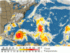
http://www.nhc.noaa.gov/text/refresh/MIATCPAT4+shtml/122042.shtml

WTNT34 KNHC 122042
TCPAT4
BULLETIN
HURRICANE IVAN ADVISORY NUMBER 42
NWS TPC/NATIONAL HURRICANE CENTER MIAMI FL
5 PM EDT SUN SEP 12 2004

...DANGEROUS HURRICANE IVAN NOW HEADING FOR WESTERN CUBA AND THE
YUCATAN CHANNEL...
...WATCH AND WARNING ISSUED FOR THE YUCATAN PENINSULA...

A HURRICANE WARNING REMAINS IN EFFECT FOR THE CAYMAN ISLANDS.

A HURRICANE WARNING IS IN EFFECT FOR CUBA FROM PINAR DEL RIO TO
CIEGO DE AVILA INCLUDING THE ISLE OF YOUTH. A HURRICANE WARNING
MEANS THAT HURRICANE CONDITIONS ARE EXPECTED WITHIN THE WARNING
AREA WITHIN THE NEXT 24 HOURS. PREPARATIONS TO PROTECT LIFE AND
PROPERTY SHOULD BE RUSHED TO COMPLETION.

A HURRICANE WATCH IS IN EFFECT FOR THE REST OF CUBA. A HURRICANE
WATCH MEANS THAT HURRICANE CONDITIONS ARE POSSIBLE WITHIN THE
WATCH AREA...GENERALLY WITHIN 36 HOURS.

AT 5 PM EDT...2100Z...THE GOVERNMENT OF MEXICO HAS ISSUED A
HURRICANE WATCH AND A TROPICAL STORM WARNING FOR THE NORTHEASTERN
YUCATAN PENINSULA FROM TULUM TO PROGRESO....INCLUDING COZUMEL.

A TROPICAL STORM WATCH REMAINS IN EFFECT FOR THE FLORIDA KEYS FROM
THE SEVEN MILE BRIDGE WESTWARD TO THE DRY TORTUGAS.

INTERESTS IN THE NORTHWESTERN CARIBBEAN SEA...AS WELL AS IN THE
CENTRAL AND EASTERN GULF OF MEXICO...SHOULD CLOSELY MONITOR THE
PROGRESS OF THIS EXTREMELY DANGEROUS HURRICANE.

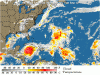
AT 5 PM EDT...2100Z...THE CENTER OF HURRICANE IVAN WAS LOCATED NEAR
LATITUDE 19.3 NORTH...LONGITUDE 82.5 WEST OR ABOUT 225 MILES...
365 KM...SOUTHEAST OF THE WESTERN TIP OF CUBA.

IVAN IS MOVING TOWARD THE WEST-NORTHWEST NEAR 10 MPH...17 KM/HR...
AND A TURN TOWARD THE NORTHWEST IS EXPECTED LATER TONIGHT OR
MONDAY. ON THIS TRACK...THE CENTER OF THE HURRICANE IS EXPECTED TO
PASS NEAR OR OVER THE WESTERN END OF CUBA MONDAY AFTERNOON OR
EVENING.

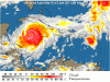
MAXIMUM SUSTAINED WINDS ARE NEAR 150 MPH...240 KM/HR...WITH HIGHER
GUSTS. THIS MAKES IVAN A STRONG CATEGORY FOUR ON THE SAFFIR-SIMPSON
HURRICANE SCALE. SOME FLUCTUATIONS IN INTENSITY ARE LIKELY DURING
THE NEXT 24 HOURS AND IVAN COULD REGAIN CATEGORY FIVE INTENSITY.


HURRICANE FORCE WINDS EXTEND OUTWARD UP TO 90 MILES...150 KM...
FROM THE CENTER...AND TROPICAL STORM FORCE WINDS EXTEND OUTWARD UP
TO 175 MILES...280 KM.

THE MINIMUM CENTRAL PRESSURE RECENTLY REPORTED BY AN AIR FORCE
RESERVE HURRICANE HUNTER AIRCRAFT WAS 916 MB...27.05 INCHES.

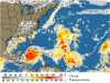
STORM SURGE FLOODING OF 5 TO 8 FEET ABOVE NORMAL TIDE LEVELS...
ALONG WITH LARGE AND DANGEROUS BATTERING WAVES... CAN BE EXPECTED
IN PORTIONS OF THE CAYMAN ISLANDS...DEPENDING ON THE EXACT TRACK OF
IVAN. COASTAL STORM SURGE FLOODING OF 20 TO 25 FEET...LOCALLY
HIGHER...ABOVE NORMAL TIDE LEVELS...ALONG WITH LARGE AND DANGEROUS
BATTERING WAVES...CAN BE EXPECTED NEAR AND TO THE EAST OF WHERE THE
CENTER MAKES LANDFALL IN CUBA. REPORTS FROM HAM RADIO OPERATORS ON
GRAND CAYMAN INDICATE THAT PEOPLE ARE STANDING ON THE ROOFS OF
HOMES DUE TO SEVERE STORM SURGE FLOODING.

RAINFALL AMOUNTS OF 8 TO 12 INCHES...POSSIBLY CAUSING LIFE-
THREATENING FLASH FLOODS AND MUD SLIDES...CAN BE EXPECTED ALONG
THE PATH OF IVAN.

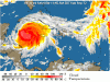
REPEATING THE 5 PM EDT POSITION...19.3 N... 82.5 W. MOVEMENT
TOWARD...WEST-NORTHWEST NEAR 10 MPH. MAXIMUM SUSTAINED
WINDS...150 MPH. MINIMUM CENTRAL PRESSURE... 916 MB.

FOR STORM INFORMATION SPECIFIC TO YOUR AREA...PLEASE MONITOR
PRODUCTS ISSUED BY YOUR LOCAL WEATHER OFFICE.

AN INTERMEDIATE ADVISORY WILL BE ISSUED BY THE NATIONAL
HURRICANE CENTER AT 8 PM EDT FOLLOWED BY THE NEXT
COMPLETE ADVISORY AT 11 PM EDT.

FORECASTER STEWART
 

Tim G

Well-Known Member
Update Hurricane Ivan

Atlantic I.R. Satellite Update

Image Delay = 30 Mins.
 

Attachments

  • Ivan at_ir_loop_15.gif
    Ivan at_ir_loop_15.gif
    588.8 KB · Views: 124

Register on WDWMAGIC. This sidebar will go away, and you'll see fewer ads.

Back
Top Bottom