-
The new WDWMAGIC iOS app is here!
Stay up to date with the latest Disney news, photos, and discussions right from your iPhone. The app is free to download and gives you quick access to news articles, forums, photo galleries, park hours, weather and Lightning Lane pricing. Learn More -
Welcome to the WDWMAGIC.COM Forums!
Please take a look around, and feel free to sign up and join the community.
You are using an out of date browser. It may not display this or other websites correctly.
You should upgrade or use an alternative browser.
You should upgrade or use an alternative browser.
The Official Hurricane Ivan thread...
- Thread starter FamilyMan
- Start date
Tim G
Well-Known Member
Update Hurricane Ivan
Hurricane Ivan Wobbles, But Florida Remains At Great Risk
UPDATED: 8:28 am EDT September 11, 2004
KEY WEST, Fla. -- A slight westward "wobble" by Hurricane Ivan gave storm-weary Florida a tiny glimmer of hope Saturday, but the still-threatened Keys stood mostly boarded up, deserted by evacuating residents and tourists well on their way to safety.
Hurricane Ivan and its 150 mph wind were still a couple of days away, but many residents and tourists had already driven north to the mainland. Before leaving, fatigued residents put up shutters and boarded windows with plywood as business dropped to a trickle in the tourism-dependent island chain.
"Charley hit and the season died," said Jose Moya, a clerk at Millie's Sundries in Key West. "It's going to be a ghost town for the rest of summer -- if we make it."
Monroe County officials ordered an evacuation of the entire 100-mile Keys, which barely rise out of the water and are extremely vulnerable to storm surge. Its the third evacuation in a month for tourists and first in three years for the chain's 79,000 residents.
At 8 a.m., Ivan was centered about 60 miles south of Montego Bay, Jamaica, Saturday morning and moving west-northwest at 8 mph. Hurricane Center forecasters said Ivan "wobbled" west a few miles south of Jamaica, possibly sparing the island the worst. But forecasters warned it could still move back to its predicted course and hit the state.
Ivan has killed 37 people in Grenada, Venezuela, Tobago, Barbados, and the Dominican Republic.
Ivan was forecast to strike Cuba and then either hit the Keys directly or pass near enough for the islands to feel hurricane force winds, said Richard Knabb, a meteorologist at the National Hurricane Center in Miami.
From there, Ivan is expected to move north in the Gulf of Mexico, reaching north Florida on Tuesday.
"But that could be anywhere from Jacksonville to Pensacola," Knabb said.
Meanwhile, on Florida's east coast, hundreds of thousands of Frances victims were still without power in the summer heat. Thousands dealt with overflowing sewers in Palm Beach County. About 767,000 homes and businesses still lacked power.
Throughout the state, memories of the previous storms that killed a total of 50 people in Florida and knocked out power to millions caused residents to line up in droves at gas stations and supermarkets. Officials said gas companies and retailers were trying to avoid the shortages that plagued areas during Charley and Frances.
The Category 4 hurricane could strengthen to a 5, top of the scale with maximum sustained winds of at least 156 mph, forecasters said. Current predictions have Ivan possibly hitting the Keys as early as Monday.
County officials weren't sure how many people heeded the evacuation order. Traffic leaving the Keys on the Overseas Highway was about double normal levels Friday, officials said.
"There are some people in Key West, they want to stay and see what Category 4 looks like and feels like," said county emergency manager Irene Toner. "That's a concern for us."
Florida has not been hit by three hurricanes in a single season since 1964, and this season has been the worst in Florida since 1992. Charley, which hit Aug. 13, and Frances, which hit Sunday, caused up to $20 billion in combined damage in Florida.
Tim G
Well-Known Member
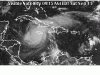
<TABLE borderColor=#000000 cellSpacing=0 cellPadding=2 width="98%" border=1><TBODY><TR><TD bgColor=#ff0000><TABLE width="100%"><TBODY><TR><TD class=large>STORM STATUS</TD><TD class=small align=right>September 11, 9:17 AM EDT</TD></TR></TBODY></TABLE></TD></TR><TR><TD bgColor=#cccccc><TABLE cellSpacing=0 cellPadding=2 width="95%" border=0><TBODY><TR><TD colSpan=2>Name: Hurricane Ivan</TD></TR><TR><TD class=small vAlign=top>Location: . This position is just south of the western tip of jamaica or about 60 miles, 95 km, South of Montego Bay Jamaica.
Lat/Long: 17.7N, 78.4W
Max Winds: 150 mph
Category: 4
</TD><TD class=small vAlign=top noWrap>Heading: West-Northwest
Speed: 8 mph
Pressure: 27.26 inches
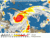
</TD></TR><TR><TD class=small align=middle colSpan=2></TD></TR></TBODY></TABLE></TD></TR></TBODY></TABLE>All Eyes Remain On Ivan The Terrible
Killer Storm Slams Jamaica -- Cuba, Keys Most Likely Next Targets
Update from the Associated Press, 8:10 a.m.
KEY WEST -- A slight westward "wobble" by Hurricane Ivan gave storm-weary Florida a tiny glimmer of hope today, but the still-threatened Keys stood mostly boarded up, deserted by evacuating residents and tourists well on their way to safety.
Hurricane Ivan and its 150 mph wind were still a couple of days away, but many residents and tourists had already driven north to the mainland. Before leaving, fatigued residents put up shutters and boarded windows with plywood as business dropped to a trickle in the tourism-dependent island chain.
"Charley hit and the season died," said Jose Moya, a clerk at Millie's Sundries in Key West. "It's going to be a ghost town for the rest of summer -- if we make it."
Lat/Long: 17.7N, 78.4W
Max Winds: 150 mph
Category: 4
</TD><TD class=small vAlign=top noWrap>Heading: West-Northwest
Speed: 8 mph
Pressure: 27.26 inches
</TD></TR><TR><TD class=small align=middle colSpan=2></TD></TR></TBODY></TABLE></TD></TR></TBODY></TABLE>All Eyes Remain On Ivan The Terrible
Killer Storm Slams Jamaica -- Cuba, Keys Most Likely Next Targets
Update from the Associated Press, 8:10 a.m.
KEY WEST -- A slight westward "wobble" by Hurricane Ivan gave storm-weary Florida a tiny glimmer of hope today, but the still-threatened Keys stood mostly boarded up, deserted by evacuating residents and tourists well on their way to safety.
Hurricane Ivan and its 150 mph wind were still a couple of days away, but many residents and tourists had already driven north to the mainland. Before leaving, fatigued residents put up shutters and boarded windows with plywood as business dropped to a trickle in the tourism-dependent island chain.
"Charley hit and the season died," said Jose Moya, a clerk at Millie's Sundries in Key West. "It's going to be a ghost town for the rest of summer -- if we make it."
1STTIME@WDW
New Member
Help?
My family is taking our first trip to WDW 9/20/04...something we have been planning for and waited for a VERY long time...this trip cannot be changed or cancelled due to work/travel restrictions...any suggestions due to the Ivan situation? We have no idea really where to turn to for information, updates, etc...there is a lot of information, very overwhelming. Thanks in advance for any help anyone can give us.
My family is taking our first trip to WDW 9/20/04...something we have been planning for and waited for a VERY long time...this trip cannot be changed or cancelled due to work/travel restrictions...any suggestions due to the Ivan situation? We have no idea really where to turn to for information, updates, etc...there is a lot of information, very overwhelming. Thanks in advance for any help anyone can give us.
Maria
New Member
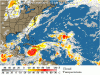
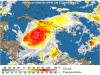
Thanks fro the images, Corrus.
Judging by the sunny day we had yesterday and are having today, noone would believe Ivan is still a threat to the Peninsula of Yucatán where I am. It´s a weird thing the relief I feel if it´s not heading straight to us, because that would mean it will hit others and probably Florida once more...
Judging by the sunny day we had yesterday and are having today, noone would believe Ivan is still a threat to the Peninsula of Yucatán where I am. It´s a weird thing the relief I feel if it´s not heading straight to us, because that would mean it will hit others and probably Florida once more...
Tim G
Well-Known Member
<TABLE borderColor=#000000 cellSpacing=0 cellPadding=2 width="98%" border=1><TBODY><TR><TD bgColor=#ff0000><TABLE width="100%"><TBODY><TR><TD class=large>STORM STATUS</TD><TD class=small align=right>September 11, 10:46 AM EDT</TD></TR></TBODY></TABLE></TD></TR><TR><TD bgColor=#cccccc><TABLE cellSpacing=0 cellPadding=2 width="95%" border=0><TBODY><TR><TD colSpan=2>Name: Hurricane Ivan</TD></TR><TR><TD class=small vAlign=top>Location: About 30 miles, 50 km southwest of the western tip of jamaica and 190 miles, 305 km, East-Southeast of Grand Cayman.
Lat/Long: 17.9N, 78.7W
Max Winds: 145 mph
Category: 4
</TD><TD class=small vAlign=top noWrap>Heading: West-Northwest
Speed: 8 mph
Pressure: 27.32 inches
</TD></TR></TBODY></TABLE></TD></TR></TBODY></TABLE>
Hurricane Ivan Advisory Number 37
Issued at: 10:46 AM EDT 9/11/04
Eye of the hurricane slowly beginning to move away from jamaica, strong winds should continue for several more hours,
A hurricane warning remains in effect for jamaica and the cayman islands.
At 11 am edt, 1500z, the government of cuba has adjusted their watches and warnings. A hurricane warning is now in effect for cuba from pinar del rio to ciego de avila including the isle of youth. A hurricane warning means that hurricane conditions are expected within the warning area within the next 24 hours. Preparations to protect life and property should be rushed to completion.
A hurricane watch remains in effect for the rest of cuba. A hurricane watch means that hurricane conditions are possible within the watch area, generally within 36 hours.
Interests in the northwestern caribbean sea, as well as in the eastern gulf of mexico, should closely monitor the progress of dangerous hurricane ivan.
At 11 am edt, 1500z, the eye center of hurricane ivan was located near latitude 17.9 north, longitude 78.7 west or about 30 miles, 50 km southwest of the western tip of jamaica and 190 miles, 305 km, east-southeast of grand cayman.
Ivan has been drifting westward during the past few hours but it should begin to move between west-northwest and northwest near 8 mph, 13 km/hr later today. On this track, ivan should move near the cayman islands in about 24 hours.
Maximum sustained winds are near 145 mph, 230 km/hr, with higher gusts. Some fluctuations in strength are expected, but ivan could become stronger during the next 24 hours.
Hurricane force winds extend outward up to 45 miles, 75 km, from the center, and tropical storm force winds extend outward up to 175 miles, 280 km.
Estimated minimum central pressure is 925 mb, 27.32 inches.
Storm surge flooding of 5 to 8 feet above normal tide levels, along with large and dangerous battering waves are occurring primarily along the south coast of jamaica but should begin to subside later today. Coastal storm surge flooding of 20 feet, locally higher, above normal tide levels, along with large and dangerous battering waves, can be expected near and to the east of where the center makes landfall in cuba.
Rainfall amounts of 8 to 12 inches, possibly causing life- threatening flash floods and mud slides, can be expected along the path of ivan.
Repeating the 11 am edt position, 17.9 n, 78.7 w. Movement toward, west-northwest near 8 mph. Maximum sustained winds, 145 mph. Minimum central pressure, 925 mb.
For storm information specific to your area, please monitor products issued by your local weather office.
An intermediate advisory will be issued by the national hurricane center at 2 pm edt followed by the next complete advisory at 5 pm edt.
speck76
Well-Known Member
1STTIME@WDW said:My family is taking our first trip to WDW 9/20/04...something we have been planning for and waited for a VERY long time...this trip cannot be changed or cancelled due to work/travel restrictions...any suggestions due to the Ivan situation? We have no idea really where to turn to for information, updates, etc...there is a lot of information, very overwhelming. Thanks in advance for any help anyone can give us.
Ivan will be long gone by the 20th....don't worry about it, and enjoy your vacation.
werlwind007
New Member
but what if another hurricane brews up?speck76 said:Ivan will be long gone by the 20th....don't worry about it, and enjoy your vacation.
speck76
Well-Known Member
werlwind007 said:but what if another hurricane brews up?
What if it doesn't.....life is too short to live in fear.
symbasys
New Member
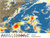
According to the latest track, they're putting Ivan off the west coast of Florida by late Monday/early Tuesday. Being in Tampa, I'm pretty interested in what it might do. Can anyone tell from the maps approximately how far offshore the current track is placing the eye from Tampa Bay? None of the maps I've seen have a distance legend. Thanks!
Register on WDWMAGIC. This sidebar will go away, and you'll see fewer ads.