The Official Hurricane Frances thread...

Tim G

Well-Known Member
Hurricane Frances Update
(South-East Florida Doppler Radar)

Image = Real Time


<TABLE borderColor=#000000 cellSpacing=0 cellPadding=2 width="98%" border=1><TBODY><TR><TD bgColor=#ff0000><TABLE width="100%"><TBODY><TR><TD class=large>STORM STATUS</TD><TD class=small align=right>September 4, 1:38 PM EDT</TD></TR></TBODY></TABLE></TD></TR><TR><TD bgColor=#cccccc><TABLE cellSpacing=0 cellPadding=2 width="95%" border=0><TBODY><TR><TD colSpan=2>Name: Hurricane Frances</TD></TR><TR><TD class=small vAlign=top>Location: About 70 miles, 115 km, East of Palm Beach Florida.
Lat/Long: 26.9N, 79.0W
Max Winds: 105 mph
Category: 2
</TD><TD class=small vAlign=top noWrap>Heading: West To West-Northwest
Speed: 5 mph
Pressure: 28.41 inches
</TD></TR></TBODY></TABLE></TD></TR></TBODY></TABLE>

2055Florida_anim12.gif
 

Tim G

Well-Known Member
Hurricane Frances Intermediate Advisory Number 43a


Issued at: 1:38 PM EDT 9/4/04

Frances hesitates, expected to resume its motion toward Florida later today,

A hurricane warning remains in effect for the east coast of Florida from Florida city northward to flagler beach, including lake okeechobee. A hurricane warning also remains in effect for the northwestern bahamas. A hurricane warning means that hurricane conditions are expected within the warning area within the next 24 hours. Preparations to protect life and property should be rushed to completion.

A tropical storm warning remains in effect from north of flagler beach to altamaha sound.

A hurricane watch remains in effect from north of flagler beach to fernandina beach.

A tropical storm warning remains in effect for the Florida peninsula on the west coast, from anna maria island around the southern end of the peninsula to just south of Florida city on the southeast coast, and for the middle and upper keys from south of Florida city to the seven mile bridge, and for Florida bay.

A tropical storm watch remains in effect for the Florida west coast to just north of anna maria island to st. Marks.

At 2 pm edt, 1800z, the large eye of hurricane frances was located by radar and reconnaissance aircraft near latitude 26.9 north, longitude 79.0 west or about 70 miles, 115 km, east of palm beach florida.

Data from radar and a reconnaissance plane indicate that frances has barely moved during the past hour. However the hurricane is expected to resume a west to west-northwest track near 5 mph, 7 km/hr today. On the forecast track, the center of the large eye of hurricane frances will be very near the Florida east coast by late tonight or early Sunday morning.

Maximum sustained winds are near 105 mph, 165 km/hr, with higher gusts. Stronger winds, especially in gusts, are possible on high rise buildings. Some strengthening is possible before landfall.

Hurricane force winds extend outward up to 105 miles, 165 km, from the center, and tropical storm force winds extend outward up to 185 miles, 295 km. Strong winds are already affecting the east coast of Florida and will be spreading inland, where warnings for hurricane and tropical storm force winds have been issued. For storm information specific to your area, please monitor products issued by your local weather office. Sustained winds of 80 mph were recently reported at jupiter inlet.

Minimum central pressure reported by a reconnaissance plane was 962 mb, 28.41 inches.

Storm surge flooding of 3 to 5 feet above normal tide levels can be expected on the west side of islands of the northern bahamas.

Coastal storm surge flooding of 4 to 6 feet above normal tide levels, along with large and dangerous battering waves, is expected near and to the north of where the center makes landfall in Florida. Storm surge flooding of 5 feet above normal levels is expected in lake okeechobee. Along the southwest Florida coast, storm surge flooding of 1 to 3 feet above normal tide levels is expected south of the path of frances.

Storm total rainfall amounts could reach 20 inches in the northwest bahamas. Rainfall amounts of 8 to 12 inches, with locally higher amounts, are expected over the Florida peninsula in association with frances.

Isolated tornadoes are possible over central Florida today and tonight.

Swells generated by frances are affecting portions of the southeastern coast of the united states. These swells could cause dangerous surf and rip currents.

Repeating the 2 pm edt position, 26.9 n, 79.0 w. Expected movement toward, west to west-northwest near 5 mph. Maximum sustained winds, 105 mph. Minimum central pressure, 962 mb.

The next advisory will be issued by the national hurricane center at 5 pm edt.
 

Tim G

Well-Known Member
Hurricane Frances Comes To Near Standstill Off Coast


UPDATED: 3:20 pm EDT September 4, 2004

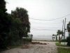
MELBOURNE, Fla. -- The outer bands of Hurricane Frances whipped Florida's Atlantic coast with 90 mph winds Saturday as the storm stalled near the state, downing trees, knocking power out to hundreds of thousands of people and ripping parts of roofs off buildings.

Frances could bring more than a foot of rain, tornadoes and heavy flooding as tens of thousands fled the area. Forecasters expected the Category 2 storm with 105-mph top sustained winds to come ashore late Saturday or early Sunday somewhere along the middle of the state's Atlantic coast.

The arrival was about a day later than earlier predictions, as residents prepared for the worst after a dragged-out process of buying canned goods and water, putting plywood sheets over windows and finding shelter.

"I turned on the TV and when I saw the storm was still 130 miles away, I said, 'Now's the time to get out,"' Dana Goegelman said after leaving Indialantic on a barrier island early Saturday. "I was so happy to get on the other side of that bridge I could have kissed the ground."

Wind gusts in Jupiter surpassed hurricane-force at 91 mph early Saturday, crashing waves into the beaches. Boats were tossed around like toys in the water, people struggled to stand up on land and trees were knocked down. The roof and door of a hangar at Palm Beach International Airport were blown off.

A yacht struggled to maneuver in the waves off West Palm Beach as its pilot tried to tie the craft to a piling. A person on the front of the boat threw a line over the side to the pole, but the boat ripped it from its foundation. The yacht eventually was tied down, with one woman suffering minor injuries.

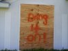
In Brevard County, two men were charged with looting for allegedly trying to break into the Ascension Catholic Church in Melbourne.

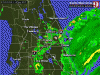
About 2.8 million residents were told to clear out -- the biggest evacuation request in Florida history -- but it was unknown how many did. At 2 p.m., Frances was centered about 70 miles east from Palm Beach, and had stalled. It was expected to resume drifting to the west-northwest at about 5 mph later in the day.

The storm had redeveloped an eye about 80 miles across, indicating that it could strengthen slightly while over open water, forecasters at the National Hurricane Center said. After hitting land, Frances' core appeared headed toward the Panhandle across the state.

Passing through the Bahamas, Frances' top sustained winds fell to 105 mph Saturday, down from 145 mph on Thursday. But its plodding pace meant it could cause disastrous flooding. Hurricane-force winds extended outward up to 105 miles from its center.

"This is going to be a tough ride for us," Gov. Jeb Bush said.

State meteorologist Ben Nelson said Frances might remain over Florida for two cycles of high tide, meaning two rounds of storm surges expected to be 4 to 6 feet north of where the eye hits.

"The water has nowhere to go and gets trapped because our elevation is so low," he said. "It could be a large mess."

Frances, carrying an imposing size twice as big as the devastating Hurricane Andrew in 1992, is expected to come ashore along the middle of Florida's eastern coast, push across the state as a tropical storm just north of Tampa and weaken to a tropical depression as it moves over the Panhandle on Monday.

Federal Emergency Management Agency director Michael Brown warned that unlike Hurricane Charley, which slammed into Florida's coast three weeks ago, Frances "has an awful lot of moisture with it" that could cause dangerous floods.

"It is a massive storm," Brown said Saturday.

A hurricane warning remained in effect for Florida's Atlantic coast, from Flagler Beach south to Florida City almost to the state's tip, and Bush declared a state of emergency for the entire state. A tropical storm warning also was extended Saturday for much of the Gulf coast and also up into Georgia.

The winds toppled trees and one gust peeled half the roof off Michelle Lyons' mobile home in Davie, just west of Fort Lauderdale, but no one was hurt.

"And we didn't even get the hurricane yet," said Lyons, 30.

Power was knocked out for about 459,000 Florida Power & Light customers along the southeast coast. The storm forced the evacuation of about 3,000 state inmates and about 500 patients at more than a dozen hospitals. Pumps were left dry at many gas stations as people rushed to fill up their tanks before the storm hit, but Bush said state officials were working to resupply stations along Florida's Turnpike.

So far, there have been about 831 reports of price gouging, Attorney General Charlie Crist said. The Chinese Green Tea restaurant in Palm Bay was charging about a $1 more for meals Saturday. When told that increasing prices because of the storm was illegal, the manager said through an interpreter that he didn't care.

Frances was set to slam into Florida's coast about three weeks after Hurricane Charley killed 27 people and caused billions of dollars in damage in southwestern Florida. Frances could cross over areas such as Orlando that were also hit by Charley.

Shelters received a steady influx of residents expecting to spend an unusual Labor Day weekend indoors. As of Saturday afternoon, about 70,000 people were in shelters statewide. Other evacuees went to hotels or friends' homes further inland. At a Red Cross shelter in Davie, elderly residents quietly huddled over a game of cards while several people played a pick-up basketball game.

"It's very organized," said Lucy Campos, who left a mobile home with a neighbor. "But I can't wait to take a shower."

Many schools and government offices closed, as did major amusement parks, the Kennedy Space Center and airports serving Fort Lauderdale, Miami and Melbourne.

FEMA mobilized 4,500 workers, three times the number sent to help victims of Charley. Officials said they had enough people and supplies in the state to handle two disaster relief operations at once.

State officials said they were prepared to deliver 5.4 million meals during the next two weeks while 13,000 electrical workers awaited in staging areas in Alabama to enter Florida and restore power. To help new mothers, baby formula was being shipped to Jacksonville to be distributed throughout the state.

The American Red Cross planned a larger relief operation than the one it conducted after Hurricane Andrew. Back then, the agency spent $81 million.

Hurricane season usually peaks in early September, and the ninth named storm of the season grew stronger Saturday in the far eastern Atlantic. Tropical Storm Ivan was about 1,575 miles east-southeast of the Lesser Antilles with winds of 60 mph.
 

Nicole

Well-Known Member
Just thought I'd let you all know that our little family made it home to NC safe and sound yesterday. We left our hotel at about 10 am, went west on 192 then up 27 to 301. We picked up I-10 at Jacksonville and then up I-95 the rest of the way home. After all my worries about traffic, there was NONE. Well - some - but no more than I'd expect any other day. Not once did we encounter any slow-downs, traffic was moving at or above the posted speed limit the whole time. Closer to Orlando we saw several homes with boarded up windows (though there were many many more that didn't have plywood or even tape!) but by the time we got to Ocala we didn't see any.

I know now how scary it is to be facing a big storm - I'm so glad we were able to get out (and thanks to the people who offered me alternate routes so we could avoid the traffic!) and our thoughts and prayers will be with all you still there in the path of Frances.
 

Tim G

Well-Known Member
Hurricane Frances Update
(Orlando Local Doppler Radar Close-Up )

Image = Real Time
 

Attachments

  • Orlando_loop04.gif
    Orlando_loop04.gif
    373.3 KB · Views: 157

Tim G

Well-Known Member
Hurricane Frances Hovers Off Florida Coast

Storm To Make Landfall Early Sunday


UPDATED: 3:54 PM EDT September 4, 2004


MELBOURNE, Fla. -- Hurricane Frances is hovering off Florida's Atlantic coast, but its winds have already downed trees and knocked out power out to thousands of Florida residents.

Forecasters describe the massive storm as being about the size of Texas. They expect it to make landfall by tomorrow.

Airports serving Fort Lauderdale, Miami and Melbourne have shut down. The Kennedy Space Center and major amusement parks are also closed.

Hurricane-force winds are already lashing parts of Florida's Atlantic coast, causing some minor damage. The few drivers out on the roads today are dodging tree branches and palm fronds. Wind and waves are tossing boats around.

It's a weaker hurricane than it was in recent days, with winds of 105 mph, but officials warn it's still dangerous and should not be underestimated. Some 2.8 million people have been told to leave their homes, the biggest evacuation order in Florida history.

At 2 p.m, Frances was centered about 70 miles east of Palm Beach, moving very slowly toward the west-northwest. the large eye of the hurricane was located by radar and reconnaissance aircraft near latitude 26.9 north, longitude 79.0 west.

The latest datea shows that Frances has barely moved during the past hour. However, the hurricane is expected to resume a west to west-northwest track near 5 mph later Saturday. On the forecast track, Hurricane Frances will be very near the Florida east coast by late Saturday night or early Sunday morning.

Maximum sustained winds are near 105 mph, with higher gusts. Stronger winds, especially in gusts, are possible on high rise buildings. And some strengthening is possible before landfall.

Hurricane force winds extend outward up to 105 miles from the center, and tropical storm force winds extend outward up to 185 miles. Strong winds are already affecting the east coast of Florida and will be spreading inland, where warnings for hurricane- and tropical-storm-force winds have been issued.

Coastal storm surge flooding of 4 to 6 feet above normal tide levels, along with large and dangerous battering waves, is expected near and to the north of where the center makes landfall in Florida. Storm surge flooding of 5 feet above normal levels is expected in Lake Okeechobee. Along the southwest Florida coast, storm surge flooding of 1 to 3 feet above normal tide levels is expected south of the path of Frances.

Rainfall amounts of 8 to 12 inches, with locally higher amounts, are expected over the Florida peninsula in association with Frances. And isolated tornadoes are possible over central Florida Saturday.

Swells generated by Frances are affecting portions of the southeastern coast of the united states. These swells could cause dangerous surf and rip currents.

If there is flooding, evacuees are being warned that it could be some time before they are allowed back home. Florida Gov. Jeb Bush has declared a state of emergency for the entire state.

"Tropical force winds, and inches and inches of rainfall, are going to impact the places that have already been devastated by Hurricane Charley," Bush said during a Saturday news conference.

At least 250,000 residents were without electricity Saturday morning as a result of the storm. Bush said state and federal officials were mobilizing to respond to the disaster.

"Once this storm has passed, there are all sort of assets that will be on the ground in the impacted areas," he said.

Mike Brown, the director of the Federal Emergency Management Agency, said residents should not take Frances lightly, even though it has been downgraded to a Category 2 hurricane.

"It is a massive storm," he said. "Unlike Charley, this storm has an awful lot of moisture with it. ...This could be a very significant flooding event."

The Federal Emergency Management Agency has four urban search and rescue teams ready to respond to the hurricane if needed, he said. In addition, Bush said the state is ready to handle post-hurricane aid, including distributing up to 1 million meals per day.

The Red Cross said it already has more than 15,000 cleanup kits ready to distribute to people whose homes have been flooded. More kits are on the way, the organization said.

A hurricane warning remains in effect for the east coast of Florida from Florida city northward to Flagler Beach, including Lake Okeechobee. A hurricane warning also remains in effect for the northwestern bahamas. A hurricane warning means that hurricane conditions are expected within the warning area within the next 24 hours. Preparations to protect life and property should be rushed to completion.

A tropical storm warning remains in effect from north of Flagler Beach to Altamaha Sound.

A hurricane watch remains in effect from north of Flagler Beach to Fernandina Beach.

A tropical storm warning remains in effect for the Florida peninsula on the west coast, from Anna Maria Island around the southern end of the peninsula to just south of Florida City on the southeast coast, and for the middle and upper keys from south of Florida City to the Seven-Mile Bridge, and for Florida Bay.

A tropical storm watch remains in effect for the Florida west coast to just north of Anna Maria Island to St. Marks
 

mkt

Disney's Favorite Scumbag™
Premium Member
i'm at work once more... just saying hi. I'm on cellphone AIM, so IM me if you can. It's somewhat stressful with panicking tourists and could use some relief
 

cindy_k

Well-Known Member
mkt said:
i'm at work once more... just saying hi. I'm on cellphone AIM, so IM me if you can. It's somewhat stressful with panicking tourists and could use some relief

:( Awww! I am watching some ducks, two swans and a crane here outside my window at SSR. They are hanging out in a rope off area of the canal.

A CM delivered a letter to our room an hour ago that said that the parks will be closed on Sunday too.

I pray the storm speeds up and gets out of here quicker.

Cindy (currently in Saratoga Springs Resort)
 

Gail Hayden

New Member
mkt said:
i'm at work once more... just saying hi. I'm on cellphone AIM, so IM me if you can. It's somewhat stressful with panicking tourists and could use some relief
I would if I could, but I don't have and will not have AIM on my computer. I do, however have ICQ, can you IM via cell that way?
 

Tim G

Well-Known Member
Photos Before, During And After Hurricane Francis

Left Frances A Message
 

Attachments

  • Y04.jpg
    Y04.jpg
    9.2 KB · Views: 126

Tim G

Well-Known Member
Photos Before, During And After Hurricane Francis

Children Making Fun Of Francis
 

Attachments

  • Y05.jpg
    Y05.jpg
    13.8 KB · Views: 124

Tim G

Well-Known Member
mkt said:
i'm at work once more... just saying hi. I'm on cellphone AIM, so IM me if you can. It's somewhat stressful with panicking tourists and could use some relief
Hang in there Rob... At least you're still dry... :D :D :D
 

Register on WDWMAGIC. This sidebar will go away, and you'll see fewer ads.

Back
Top Bottom