dstrawn9889
Well-Known Member
well, about the same as the laydown for DS
Isn't that kinda far away from where the construction is going on to be a staging area?
Thank you for the updates. I guess this gives us an idea that things start up perhaps in July. In the meantime, I assume they are busy clearing out / demoing whatever needs to go in those areas and doing other prep work.A permit was filed with the South Florida Water Management District for DHS-BOH Construction Laydown Yard which is another name for a staging area. This is where the construction trailers and contractor parking will go. The proposed schedule is to start construction in July/August 2016 and complete by October 2016. The permit says this area will be used by "three separate project teams", so this is probably some combination of TSL, SWL, the new retention pond and parking changes, and/or the new entrance road.
View attachment 139556
It will be plenty close for what it's being used for. The idea behind this (other than parking for the hundreds of workers) is to stock pile major components until everything is on site. Essentially what this does is save time as they can for example start bringing in all of the steel building skeleton components and pile them up in the yard while the foundations are being poured. Once all of the steel for a project is at the staging site they can quickly transport just the components they need to the job site which saves space and allows more work to be done in a smaller area. This staging yard will be used in this fashion for quite a bit of the project. It will only be during the final stages that the lot will be used primarily for parking and quite honestly if you want to know what's going on on site you can look at the materials stockpiled in the staging yard and get a darn good idea of where they are in the project and what will be next.Isn't that kinda far away from where the construction is going on to be a staging area?
could any be this facade? it looks like there waiting for something so it can be demoed.

i heard theres land clearing near the tolls entrance for trees through screamscapeConstruction on the "construction access road" will likely start very soon. All the flags for the road are in place, and when coming in to Studios through the main entrance they have signs up that say "Left Lane Closed Ahead" and then the merge symbol (although both signs are currently covered).
i heard theres land clearing near the tolls entrance for trees through screamscape
so most likely moving the tolls if im correctJus checked, and they do have pictures of that, not that they show much. There is a lot of clearing to be done, ultimately this whole area will be cleared.
View attachment 140993
So with just that entrance road (which i'm sure can be rerouted) in the way, is there any way some of that land gets used for park use going forward?Jus checked, and they do have pictures of that, not that they show much. There is a lot of clearing to be done, ultimately this whole area will be cleared.
View attachment 140993
so most likely moving the tolls if im correct
Well technically you are correct but the tolls are not being moved to this spot they are clearing. The tolls are being relocated to the far end of the parking lot and the new park entrance will be from over by ESPN.
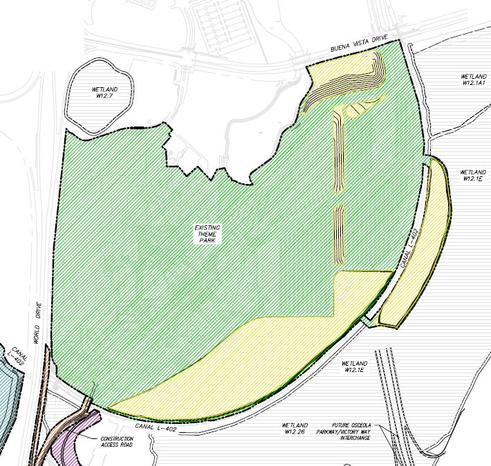
the coma shaped piece on the far left of the photo. The new entry road is also depicted just below it.
I agree with another poster that those yellow areas to the right look like land for ramps to garages. And those parallel black lines may be a rough outline for the garages. Possibly runoff pipes.Well technically you are correct but the tolls are not being moved to this spot they are clearing. The tolls are being relocated to the far end of the parking lot and the new park entrance will be from over by ESPN.
the coma shaped piece on the far left of the photo. The new entry road is also depicted just below it.
I agree with another poster that those yellow areas to the right look like land for ramps to garages. And those parallel black lines may be a rough outline for the garages. Possibly runoff pipes.
Well technically you are correct but the tolls are not being moved to this spot they are clearing. The tolls are being relocated to the far end of the parking lot and the new park entrance will be from over by ESPN.
the coma shaped piece on the far left of the photo. The new entry road is also depicted just below it.
So with just that entrance road (which i'm sure can be rerouted) in the way, is there any way some of that land gets used for park use going forward?
Register on WDWMAGIC. This sidebar will go away, and you'll see fewer ads.