This is not seeing big picture. Thousands on the West Coast ( ie Tampa St Pete etc ) are escaping harms way of a Cat 4 and storm surge. Thousands of hotel rooms are in Central Florida. Like what thousands did during Charley 2004 when all hotel rooms were filled in Central FL it will happen again. Central FL welcomes them with open arms with them fleeing the hurricane.We have this type of crap every single time a hurricane heads for east or west central FL. If you don't live there, you don't need to be there. Finite resources don't need to be used for tourists who could have left but chose not to, because Disney!! There is going to be massive amounts of tree damage and widespread power outages, at minimum, in central FL.
-
Welcome to the WDWMAGIC.COM Forums!
Please take a look around, and feel free to sign up and join the community.
You are using an out of date browser. It may not display this or other websites correctly.
You should upgrade or use an alternative browser.
You should upgrade or use an alternative browser.
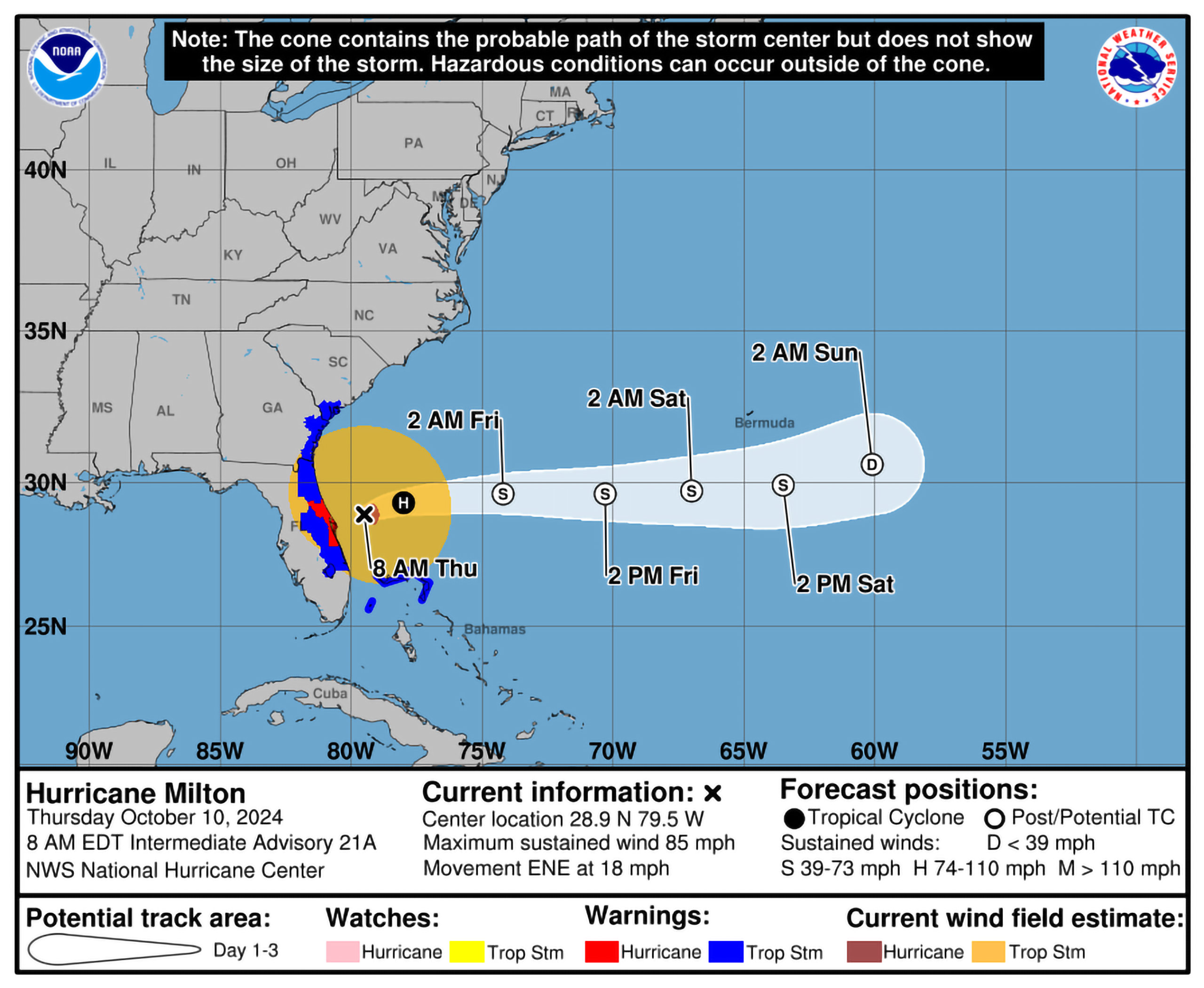
Hurricane Milton coming to FL
- Thread starter Touchdown
- Start date
Figgy1
Well-Known Member
If it's anything like Sandy expect damage from coast to coast in a wide band. I pray it's nowhere near that badParkinson said the latest advisory from the National Hurricane Center suggests a peak at Category 4 and a landfall intensity of Category 3.
"As always, this far out, people need to prepare for one category above, which means preparations should be for a Category 5 maximum, and a strong Category 4 landfall," Parkinson said.
Landfall location is key
Forecast models show Milton headed for Florida's west coast. The direction Milton approaches from is a large concern, Parkinson said. Instead of running parallel to the coast, Milton is coming in at a 90-degree angle.
"That means that storm surge will be piled into the coast," Parkinson said, comparing it to what happened in New Jersey during Hurricane Sandy.

Hurricane Milton, a powerful Category 4 storm, prompts new warnings for Florida amid mass evacuations
Milton is a powerful Category 4 hurricane with a path forecast to bring it ashore along Florida's west coast this week.www.cbsnews.com
This is not seeing big picture. Thousands on the West Coast ( ie Tampa St Pete etc ) are escaping harms way of a Cat 4 and storm surge. Thousands of hotel rooms are in Central Florida. Like what thousands did during Charley 2004 when all hotel rooms were filled in Central FL it will happen again. Central FL welcomes them with open arms with them fleeing the hurricane.
Thank you for saying this.
Tampa Airport To Close for Hurricane Milton: Orlando International and Walt Disney World Operations Update
Tampa Airport To Close for Hurricane Milton: Orlando International and Walt Disney World Operations Update
Tampa Airport To Close for Hurricane Milton: Orlando International and Walt Disney World Operations Update
 www.wdwmagic.com
Gringrinngghost
Well-Known Member
Fun factoid: I lived 30 miles to the north of where Hurricane Sandy made landfall.If it's anything like Sandy expect damage from coast to coast in a wide band. I pray it's nowhere near that bad
Tampa Airport To Close for Hurricane Milton: Orlando International and Walt Disney World Operations Update
Tampa Airport To Close for Hurricane Milton: Orlando International and Walt Disney World Operations Update
Tampa Airport To Close for Hurricane Milton: Orlando International and Walt Disney World Operations Update
Expect MCO to close late tomorrow.
Gringrinngghost
Well-Known Member
That I don’t know, but I hope so. 429 is nice to not have to get on 192.Does that include 429?
Not that I'm going anywhere as there's a brand new ACE Hardware in Hamlin...
That I don’t know, but I hope so. 429 is nice to not have to get on 192.
Until you get to the construction on 429 near the Turnpike exit....
Gringrinngghost
Well-Known Member
Code:
074
WTNT34 KNHC 071453
TCPAT4

BULLETIN
Hurricane Milton Advisory Number  10
NWS National Hurricane Center Miami FL       AL142024
1000 AM CDT Mon Oct 07 2024

...MILTON CONTINUING TO RAPIDLY INTENSIFY..
...FORECAST TO BECOME A CATEGORY 5 HURRICANE...

SUMMARY OF 1000 AM CDT...1500 UTC...INFORMATION
-----------------------------------------------
LOCATION...21.7N 91.7W
ABOUT 130 MI...210 KM WNW OF PROGRESO MEXICO
ABOUT 720 MI...1160 KM SW OF TAMPA FLORIDA
MAXIMUM SUSTAINED WINDS...155 MPH...250 KM/H
PRESENT MOVEMENT...ESE OR 110 DEGREES AT 9 MPH...15 KM/H
MINIMUM CENTRAL PRESSURE...933 MB...27.55 INCHES


WATCHES AND WARNINGS
--------------------
CHANGES WITH THIS ADVISORY:

A Hurricane Watch has been issued for Lake Okeechobee.

SUMMARY OF WATCHES AND WARNINGS IN EFFECT:

A Hurricane Warning is in effect for...
* Celestun to Rio Lagartos

A Hurricane Watch is in effect for...
* Rio Lagartos to Cabo Catoche
* Campeche to south of Celestun
* Florida Gulf coast from Chokoloskee to the mouth of the Suwanee
River, including Tampa Bay
* Dry Tortugas
* Lake Okeechobee

A Storm Surge Watch is in effect for...
* Florida Gulf coast from Flamingo northward to the mouth of the
Suwannee River, including Charlotte Harbor and Tampa Bay

A Tropical Storm Warning is in effect for...
* Rio Lagartos to Cancun
* Campeche to south of Celestun

A Tropical Storm Watch is in effect for...
* Florida Gulf coast from Flamingo to south of Chokoloskee
* Florida Gulf coast north of the mouth of the Suwanee River to
Indian Pass
* Lower, Middle, and Upper Florida Keys, including Florida Bay

A Hurricane Warning means that hurricane conditions are expected
somewhere within the warning area.  A warning is typically issued
36 hours before the anticipated first occurrence of
tropical-storm-force winds, conditions that make outside
preparations difficult or dangerous.  Preparations to protect life
and property should be rushed to completion.

A Tropical Storm Warning means that tropical storm conditions are
expected somewhere within the warning area within 36 hours.

A Storm Surge Watch means there is a possibility of life-
threatening inundation, from rising water moving inland from the
coastline, in the indicated locations during the next 48 hours.
For a depiction of areas at risk, please see the National Weather
Service Storm Surge Watch/Warning Graphic, available at
hurricanes.gov.

A Hurricane Watch means that hurricane conditions are possible
within the watch area.  A watch is typically issued 48 hours
before the anticipated first occurrence of tropical-storm-force
winds, conditions that make outside preparations difficult or
dangerous.

A Tropical Storm Watch means that tropical storm conditions are
possible within the watch area, generally within 48 hours.

Interests in the remainder of the Yucatan peninsula of Mexico, the
Florida Peninsula, the Florida Keys, and the northwestern Bahamas
should monitor the progress of this system. Additional watches and
warnings will likely be issued this afternoon.

For storm information specific to your area in the United
States, including possible inland watches and warnings, please
monitor products issued by your local National Weather Service
forecast office. For storm information specific to your area
outside of the United States, please monitor products issued by
your national meteorological service.


DISCUSSION AND OUTLOOK
----------------------
At 1000 AM CDT (1500 UTC), the eye of Hurricane Milton was
located near latitude 21.7 North, longitude 91.7 West. Milton is
moving toward the east-southeast near 9 mph (15 km/h). An eastward
to east-southeastward motion is forecast through tonight, followed
by a turn toward the east and northeast on Tuesday and Wednesday.
On the forecast track, Milton is forecast to move near or just
north of the Yucatan Peninsula today and Tuesday, then cross the
eastern Gulf of Mexico and approach the west coast of the Florida
Peninsula by Wednesday.

Data from NOAA and Air Force Reserve Hurricane Hunter aircraft
indicate that the maximum sustained winds have increased to near
155 mph (250 km/h) with higher gusts.  Milton is a category 4
hurricane on the Saffir-Simpson Hurricane Wind Scale.  Milton is
forecast to become a category 5 hurricane later today and become a
large hurricane over the eastern Gulf of Mexico.

Hurricane-force winds extend outward up to 30 miles (45 km) from the
center and tropical-storm-force winds extend outward up to 80 miles
(130 km).

The estimated minimum central pressure is 933 mb (27.55 inches)
based on Air Force Reserve dropsonde data.


HAZARDS AFFECTING LAND
----------------------
Key Messages for Hurricane Milton can be found in the Tropical
Cyclone Discussion under AWIPS header MIATCDAT4 and WMO header
WTNT44 KNHC and on the web at hurricanes.gov/text/MIATCDAT4.shtml

STORM SURGE:  A storm surge will raise water levels by as much as 4
to 6 feet above ground level along the northern coast of the
Yucatan Peninsula in areas of onshore winds.  Near the coast, the
surge will be accompanied by large and destructive waves.

The combination of a dangerous storm surge and the tide will cause
normally dry areas near the coast to be flooded by rising waters
moving inland from the shoreline.  The water could reach the
following heights above ground somewhere in the indicated areas if
the peak surge occurs at the time of high tide...

Anclote River, FL to Englewood, FL...8-12 ft
Tampa Bay...8-12 ft
Yankeetown, FL to Anclote River, FL...5-10 ft
Englewood, FL to Bonita Beach, FL...5-10 ft
Charlotte Harbor...5-10 ft
Bonita Beach, FL to Chokoloskee, FL...4-7 ft
Suwannee River, FL to Yankeetown, FL...3-5 ft

The deepest water will occur along the immediate coast near and to
the south of the landfall location, where the surge will be
accompanied by large and dangerous waves.  Surge-related flooding
depends on the relative timing of the surge and the tidal cycle,
and can vary greatly over short distances.  For information
specific to your area, please see products issued by your local
National Weather Service forecast office.

For a complete depiction of areas at risk of storm surge
inundation, please see the National Weather Service Peak Storm
Surge Graphic, available at
hurricanes.gov/graphics_at4.shtml?peakSurge.

RAINFALL: Rainfall amounts of 5 to 10 inches, with localized totals
up to 15 inches, are expected across portions of the Florida
Peninsula and the Keys through Wednesday night. This rainfall brings
the risk of considerable flash, urban, and areal flooding, along
with the potential for moderate to major river flooding.

Milton will also produce rainfall totals of 2 to 4 inches with
isolated totals around 6 inches across northern portions of the
Yucatan Peninsula.

For a complete depiction of forecast rainfall associated with
Hurricane Milton, please see the National Weather Service Storm
Total Rainfall Graphic, available at
hurricanes.gov/graphics_at4.shtml?rainqpf and the Flash Flood Risk
graphic at hurricanes.gov/graphics_at4.shtml?ero.

WIND:  Hurricane conditions are expected in the warning area in
Mexico beginning late today or tonight, with tropical storm
conditions expected to begin early this afternoon. Hurricane
conditions are possible in the watch areas in Mexico beginning
tonight and Tuesday, and tropical storm conditions are expected in
the tropical storm warning area beginning later today. Hurricane
conditions are possible in the Hurricane Watch area in Florida on
Wednesday, and tropical storm conditions are possible in the
Tropical Storm Watch area on Wednesday.

SURF:  Swells generated by the system are expected to continue
to affect much of the whole Gulf Coast within the next day or two,
and are likely to cause life-threatening surf and rip current
conditions.  Please consult products from your local weather office.


NEXT ADVISORY
-------------
Next intermediate advisory at 100 PM CDT.
Next complete advisory at 400 PM CDT.

$$
Forecaster BlakeGringrinngghost
Well-Known Member
From the forecast advisory:

Code:
The hurricane is still moving east-southeastward, now about 8 kt.
Global models continue to insist that Milton will turn eastward
soon as the frontal low pressure area over the northeastern Gulf of
Mexico departs.  The new forecast near Mexico is about the same as
the previous one, but is close enough to bring hurricane-force
winds to the northern portion of Yucatan Peninsula.  Later, a new
mid-level trough dropping into the northwestern Gulf of Mexico
should then cause Milton to move east-northeastward to northeastward
at a faster forward speed.  The latest model fields are a bit left
of the previous runs, and the official NHC track forecast is shifted
to the north.  This forecast is close to a consensus of the latest
GFS, ECMWF and regional hurricane models. Note that this track is
closer to the model fields rather than the model trackers which
appear to be too far south.

Milton is likely to become a category 5 hurricane later today
with light shear and very warm waters in its path. By tomorrow,
its intensity should be dictated by any eyewall replacement
cycles, which will likely cause the system to gradually weaken
but grow larger.  After 36 h, Milton is expected to encounter a
much less favorable environment with strong shear and dry air
entrainment. Therefore, some weakening is anticipated before the
hurricane reaches the Florida Gulf coast.  However, the system is
still likely to be a large and powerful hurricane at landfall in
Florida, with life-threatening hazards at the coastline and well
inland. After landfall, Milton should weaken and start extratropical
transition, which should be complete by 96 h.Figgy1
Well-Known Member
We were almost on the Delaware trees down all over the place power out for a week, others near us were not so lucky a relative near Ledgewood had a tree fall on their house and yet we were all much luckier than those down the shoreFun factoid: I lived 30 miles to the north of where Hurricane Sandy made landfall.
Everybody in Central Florida please stay safe
Purduevian
Well-Known Member
From CNN
An extremely warm Gulf of Mexico fueling Milton’s ongoing rapid intensification is now expected to propel the hurricane into rare territory.
Milton has sustained winds of 155 mph, according to the National Hurricane Center. That’s just 2 mph away from a Category 5 hurricane, which the storm is now forecast to reach later today.
Gringrinngghost
Well-Known Member
For Orlando:
CC: @wdwmagic
Code:
Milton Local Watch/Warning Statement/Advisory Number 10
National Weather Service Melbourne FL  AL142024
1058 AM EDT Mon Oct 7 2024

FLZ045-072300-
/O.NEW.KMLB.HU.A.1014.241007T1458Z-000000T0000Z/
Orange-
1058 AM EDT Mon Oct 7 2024

...HURRICANE WATCH IN EFFECT...

A Hurricane Watch means hurricane-force winds are possible somewhere
within this area within the next 48 hours

* WIND
    - LATEST LOCAL FORECAST: Equivalent Cat 1 Hurricane force wind
        - Peak Wind Forecast: 60-80 mph with gusts to 95 mph
        - Window for Tropical Storm force winds: Wednesday afternoon
          until Thursday morning
        - Window for Hurricane force winds: Wednesday evening until
          early Thursday morning

    - THREAT TO LIFE AND PROPERTY THAT INCLUDES TYPICAL FORECAST
      UNCERTAINTY IN TRACK, SIZE AND INTENSITY: Potential for wind 74
      to 110 mph
        - PLAN: Plan for life-threatening wind of equivalent CAT 1 or
          2 hurricane force.
        - PREPARE: Efforts to protect life and property should now be
          rigorously underway. Prepare for considerable wind damage.
        - ACT: Act now to complete preparations before the wind
          becomes hazardous.

    - POTENTIAL IMPACTS: Extensive
        - Considerable roof damage to sturdy buildings, with some
          having window, door, and garage door failures leading to
          structural damage. Mobile homes severely damaged, with some
          destroyed. Damage accentuated by airborne projectiles.
          Locations may be uninhabitable for weeks.
        - Many large trees snapped or uprooted along with fences and
          roadway signs blown over.
        - Some roads impassable from large debris, and more within
          urban or heavily wooded places. Several bridges, causeways,
          and access routes impassable.
        - Large areas with power and communications outages.

* FLOODING RAIN
    - LATEST LOCAL FORECAST: Flood Watch is in effect
        - Peak Rainfall Amounts: Additional 4-8 inches, with locally
          higher amounts

    - THREAT TO LIFE AND PROPERTY THAT INCLUDES TYPICAL FORECAST
      UNCERTAINTY IN TRACK, SIZE AND INTENSITY: Potential for major
      flooding rain
        - PLAN: Emergency plans should include the potential for
          major flooding from heavy rain. Evacuations and rescues are
          likely.
        - PREPARE: Strongly consider protective actions, especially
          if you are in an area vulnerable to flooding.
        - ACT: Heed any flood watches and warnings. Failure to take
          action will likely result in serious injury or loss of life.

    - POTENTIAL IMPACTS: Extensive
        - Major rainfall flooding may prompt many evacuations and
          rescues.
        - Rivers and tributaries may rapidly overflow their banks in
          multiple places. Small streams, creeks, canals, and ditches
          may become dangerous rivers. In mountain areas, destructive
          runoff may run quickly down valleys while increasing
          susceptibility to rockslides and mudslides. Flood control
          systems and barriers may become stressed.
        - Flood waters can enter many structures within multiple
          communities, some structures becoming uninhabitable or
          washed away. Many places where flood waters may cover
          escape routes. Streets and parking lots become rivers of
          moving water with underpasses submerged. Driving conditions
          become dangerous. Many road and bridge closures with some
          weakened or washed out.

* TORNADO
    - LATEST LOCAL FORECAST:
        - Situation is somewhat favorable for tornadoes

    - THREAT TO LIFE AND PROPERTY THAT INCLUDES TYPICAL FORECAST
      UNCERTAINTY IN TRACK, SIZE AND INTENSITY: Potential for a few
      tornadoes
        - PLAN: Emergency plans should include the potential for a
          few tornadoes.
        - PREPARE: If your shelter is particularly vulnerable to
          tornadoes, prepare to relocate to safe shelter before
          hazardous weather arrives.
        - ACT: If a tornado warning is issued, be ready to shelter
          quickly.

    - POTENTIAL IMPACTS: Limited
        - The occurrence of isolated tornadoes can hinder the
          execution of emergency plans during tropical events.
        - A few places may experience tornado damage, along with
          power and communications disruptions.
        - Locations could realize roofs peeled off buildings,
          chimneys toppled, mobile homes pushed off foundations or
          overturned, large tree tops and branches snapped off,
          shallow-rooted trees knocked over, moving vehicles blown
          off roads, and small boats pulled from moorings.
CC: @wdwmagic
Gringrinngghost
Well-Known Member
We were 28 hours in the hospital grid.We were almost on the Delaware trees down all over the place power out for a week, others near us were not so lucky a relative near Ledgewood had a tree fall on their house and yet we were all much luckier than those down the shore
Everybody in Central Florida please stay safe
ToTBellHop
Well-Known Member
As for WDW, with the slowed storm, tomorrow should be fine. Truly dangerous winds look to occur late Wednesday into early Thursday. Perhaps they’ll try to open the parks during the day Wednesday and close early? Obviously no nighttime spectaculars.
It’s now forecast to reach Cat. 5…
It’s now forecast to reach Cat. 5…
IanDLBZF
Well-Known Member
Hillsborough, Sarasota, and Hernando Counties have issued MANDATORY evacuation orders already so far. I’d expect others to follow.
Wow , Hillsborough which is the Tampa area has 1.4 million residents. Many probably bumper to bumper on I-4 to Orlando / Kissimmee.Hillsborough, Pinellas and Hernando Counties have issued MANDATORY evacuation orders already so far. I’d expect others to follow.
Register on WDWMAGIC. This sidebar will go away, and you'll see fewer ads.