Late Aug/Sept is peak hurricane season . I'm keeping an eye on it too.Yeah we’re supposed to be there a week from now. The ones coming up through the Gulf aren’t the ones that worry me; it’s the one developing off the coast of Africa that’s giving me pause.
-
Welcome to the WDWMAGIC.COM Forums!
Please take a look around, and feel free to sign up and join the community.
You are using an out of date browser. It may not display this or other websites correctly.
You should upgrade or use an alternative browser.
You should upgrade or use an alternative browser.
News Storms a brewin’ in the Atlantic
- Thread starter Tha Realest
- Start date
This is why I rely on WebMD. I'm a hypochondriac by nature, and it always confirms my priors.Don’t ask a weather person...they are always wrong.
Figments Friend
Well-Known Member
Looks like a double punch to Louisiana ....one day after the other......yikes!

The one I was watching - the "third disturbance," or "disturbance 3" - which was forming off of Africa was just downgraded to a 0% chance of forming within the next 48 hours or the next 5 days. The other two - Laura and Marco - look to be heading northward once they hit the gulf.
JoeCamel
Well-Known Member
Watching the satellite loops I just don't see Marco doing much. More like the Nature Coast with rain but New Orleans? It would have to take quite a turn from it's present direction.
Laura is being shredded by interaction with land for the next day or so and it will be weakened. Once both of these enter the gulf they might strengthen but I can't see anything major here.
I have been here in the west coast of Florida for 20 years and am not planning on taking any precautions beyond what I do at the start of every hurricane season.
I could be wrong, it happens
Last edited:
Spaghetti a la Marco for breakfast.


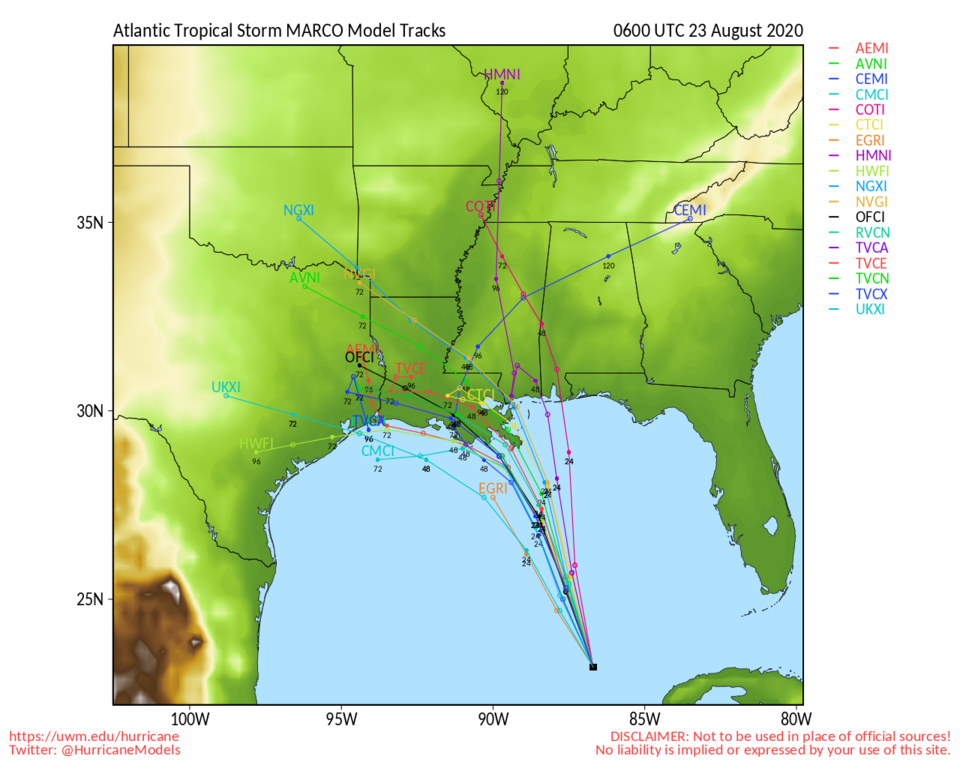
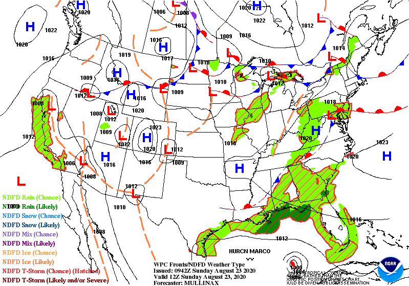
NOT A WEATHERMAN, but it looks to me like the High over Arkansas and the Low over Southern New Mexico will shift just far enough east by tomorrow that they'll create a channel for Marco right over Louisiana. Just like the models said. Assuming things don't stop or accelerate.
NOT A WEATHERMAN, but it looks to me like the High over Arkansas and the Low over Southern New Mexico will shift just far enough east by tomorrow that they'll create a channel for Marco right over Louisiana. Just like the models said. Assuming things don't stop or accelerate.
JoeCamel
Well-Known Member
I watch this loop and can't see LA. More like the panhandle/nature coast. Looks like NNE movement and it would have to turn into the high. Not a weatherman but it seems that way to meSpaghetti a la Marco for breakfast.
View attachment 492623
View attachment 492624
NOT A WEATHERMAN, but it looks to me like the High over Arkansas and the Low over Southern New Mexico will shift just far enough east by tomorrow that they'll create a channel for Marco right over Louisiana. Just like the models said. Assuming things don't stop or accelerate.
I suggest you use this website: http://skeetobiteweather.com/ the first page that pops up will have any named storms that are in or expected to be near the Atlantic side of the US. It will show not only the official paths of the storms that are being used by local meteorologist but will also show you the all the main computer models. If you prefer a more difficult to understand source you can also use http://www.tropicalstormrisk.com/ it will also give you the highlights along with forecast for all of August that is pretty much what most experts would use as a source... When I was working in a gas trading company that was concerned with hurricanes in the Gulf region those were two of the most popular sources that traders would use. Frankly I suggest you just stick with the skeetobiteweather but I included the other just so you could see that they basically show you the same information only skeetobite is more to the point and leaves out a lot of the really long term stuff that is more guess than anything else.So with the dropping numbers and our local school district’s decision to go remote learning, we worked up enough courage to do a quick trip to visit in less than two weeks. Refundable airfare booked (yay SWA!) and was about to pull the trigger on a room but now see there’s a series of developing storms meteorologists are tracking. We’ve done trips to the region in the past (we flew around a hurricane once en route to our honeymoon in the Virgin Islands) but what’s the read on the ground in FL / central FL for these storm systems?
JoeCamel
Well-Known Member
I like MikeI suggest you use this website: http://skeetobiteweather.com/ the first page that pops up will have any named storms that are in or expected to be near the Atlantic side of the US. It will show not only the official paths of the storms that are being used by local meteorologist but will also show you the all the main computer models. If you prefer a more difficult to understand source you can also use http://www.tropicalstormrisk.com/ it will also give you the highlights along with forecast for all of August that is pretty much what most experts would use as a source... When I was working in a gas trading company that was concerned with hurricanes in the Gulf region those were two of the most popular sources that traders would use. Frankly I suggest you just stick with the skeetobiteweather but I included the other just so you could see that they basically show you the same information only skeetobite is more to the point and leaves out a lot of the really long term stuff that is more guess than anything else.
Mike's Weather Page... powered by Firman Power Equipment!
John park hopper
Well-Known Member
I like the National Hurricane Center web page they seem to be correct more often than not, they have both storms going into New Orleans at the present time
I've seen his page before, I just thought it was a bit overwhelming for someone that just wants to try and get some peace of mind. His page seems to throw everything at the visitor which could lead to some unnecessary anxiety.I like Mike
Mike's Weather Page... powered by Firman Power Equipment!
spaghettimodels.com
JoeCamel
Well-Known Member
All the tools in one place for me. Lets me see raw data and compare to what the models are seeing.I've seen his page before, I just thought it was a bit overwhelming for someone that just wants to try and get some peace of mind. His page seems to throw everything at the visitor which could lead to some unnecessary anxiety.
Can be overwhelming but I live in Florida so a needed skill.
Grew up around New Orleans, and then lived in the Tampa area for most of a decade. I have a bad feeling about these two... if I lived in Louisiana, I believe I'd be headed north this afternoon.All the tools in one place for me. Lets me see raw data and compare to what the models are seeing.
Can be overwhelming but I live in Florida so a needed skill.
John park hopper
Well-Known Member
Looks like New Orleans is going to take a one -two punch hope they both stay at a cat 1 and the pumps are working to get the water out of New Orleans
Understood. It brought back memories to the screens the weather guy on the trade floor had up when a hurricane was forming. Not that he was any more accurate at predicting where it was actually going to hit or how much damage it was going to do. Until you are within about 72 hours of landfall things are still likely to be in a state of flux.All the tools in one place for me. Lets me see raw data and compare to what the models are seeing.
Can be overwhelming but I live in Florida so a needed skill.
Doberge
True Bayou Magic
Raise your hand if you remember watching Nash Roberts and plotting the hurricane's coordinates on the map out of the Times-Picayune...
They'd bring him out of retirement in the late 1990s just for hurricanes. It drove others nuts that his paper and marker models outperformed their computer modules.
I have a bad feeling about these two... if I lived in Louisiana, I believe I'd be headed north this afternoon.
I'm in New Orleans and there's little concern, rightly or wrongly. Everything is shutting down for Monday and many are hoping for normal days Tuesday and Wednesday. I'm more worried about Laura now being forecasted as a category 2 and hitting just west than a more direct hit from a strong tropical storm or category 1.
muddyrivers
Well-Known Member
I'm in New Orleans and there's little concern, rightly or wrongly. Everything is shutting down for Monday and many are hoping for normal days Tuesday and Wednesday. I'm more worried about Laura now being forecasted as a category 2 and hitting just west than a more direct hit from a strong tropical storm or category 1.
I agree, it looks like Laura is going to be more of a gut punch for New Orleans not only because it's forecasted to be stronger, but also because it's coming only 48 hours after Marco rolls through so there will be little time to do any repairs or cleanup caused by Marco. I'm hearing reports Laura may get up to a Cat 3 since it's staying south of Cuba and will have some previously unexpected time to strengthen.
Keeping my fingers crossed for the people impacted and hopefully the city of New Orleans will fare better than in the past!
Register on WDWMAGIC. This sidebar will go away, and you'll see fewer ads.
