-
Welcome to the WDWMAGIC.COM Forums!
Please take a look around, and feel free to sign up and join the community.
You are using an out of date browser. It may not display this or other websites correctly.
You should upgrade or use an alternative browser.
You should upgrade or use an alternative browser.
Hurricane Helene (2024)
- Thread starter Gringrinngghost
- Start date
Ayla
Well-Known Member
Which is what meteorologists have been saying from the beginning.This thing is blowing up as I type. She is tightening up and the core is starting to cook. I think people are going to wake up in the morning to a completely different storm from when they went to bed
A flood warning just popped on my phone until the 29th. We (Middle Tennessee) are in the 5 to 9 inches area and we have had 3 in the last week. Looks like it will be a wet weekend.Weird Helene is really trying to tour all of Tennessee. Wouldn’t be on my top 10 last, but guess ymmv
Last edited:
Cat 4 is going to have some beasty winds when the pressure is tight. Rough time for that big bend area to say the least.
Rain wise, if thus thing picks up speed like all forecasts have had it, experts point out that at least this is what takes the flooding concern out if the equation on the level like the recent large slow movers for most areas.
Rain wise, if thus thing picks up speed like all forecasts have had it, experts point out that at least this is what takes the flooding concern out if the equation on the level like the recent large slow movers for most areas.

The GEFS is swinging farther East. The track is still really tight on all models. Closest I have seen for a storm in a long time.
If you have character meet and greets while hunkered down in the resort that’s special. In 99’ when all of us at Coronado were instructed to leave our rooms and sleep in the resort convention center , it was frequent meeting with Mickey and friends.Not sure how much park time you'll get but if you have to ride out the storm for an extended period in AKL you'll find it quite pleasant. As others have said, CMs will make sure you're taken care of.
John park hopper
Well-Known Member
4:00 am

Tornado Watch Issued for Walt Disney World Area as Hurricane Helene Approaches Florida
Tornado Watch Issued for Walt Disney World Area as Hurricane Helene Approaches Florida
Tornado Watch Issued for Walt Disney World Area as Hurricane Helene Approaches Florida
 www.wdwmagic.com
John park hopper
Well-Known Member

Code:
000
WTNT34 KNHC 261139
TCPAT4
BULLETIN
Hurricane Helene Intermediate Advisory Number 12A
NWS National Hurricane Center Miami FL AL092024
700 AM CDT Thu Sep 26 2024
...HELENE BECOMES A CATEGORY 2 HURRICANE WITH SIGNIFICANT
ADDITIONAL STRENGTHENING EXPECTED BEFORE LANDFALL IN FLORIDA...
...PREPARATIONS TO PROTECT LIFE AND PROPERTY SHOULD BE RUSHED TO
COMPLETION...
SUMMARY OF 700 AM CDT...1200 UTC...INFORMATION
----------------------------------------------
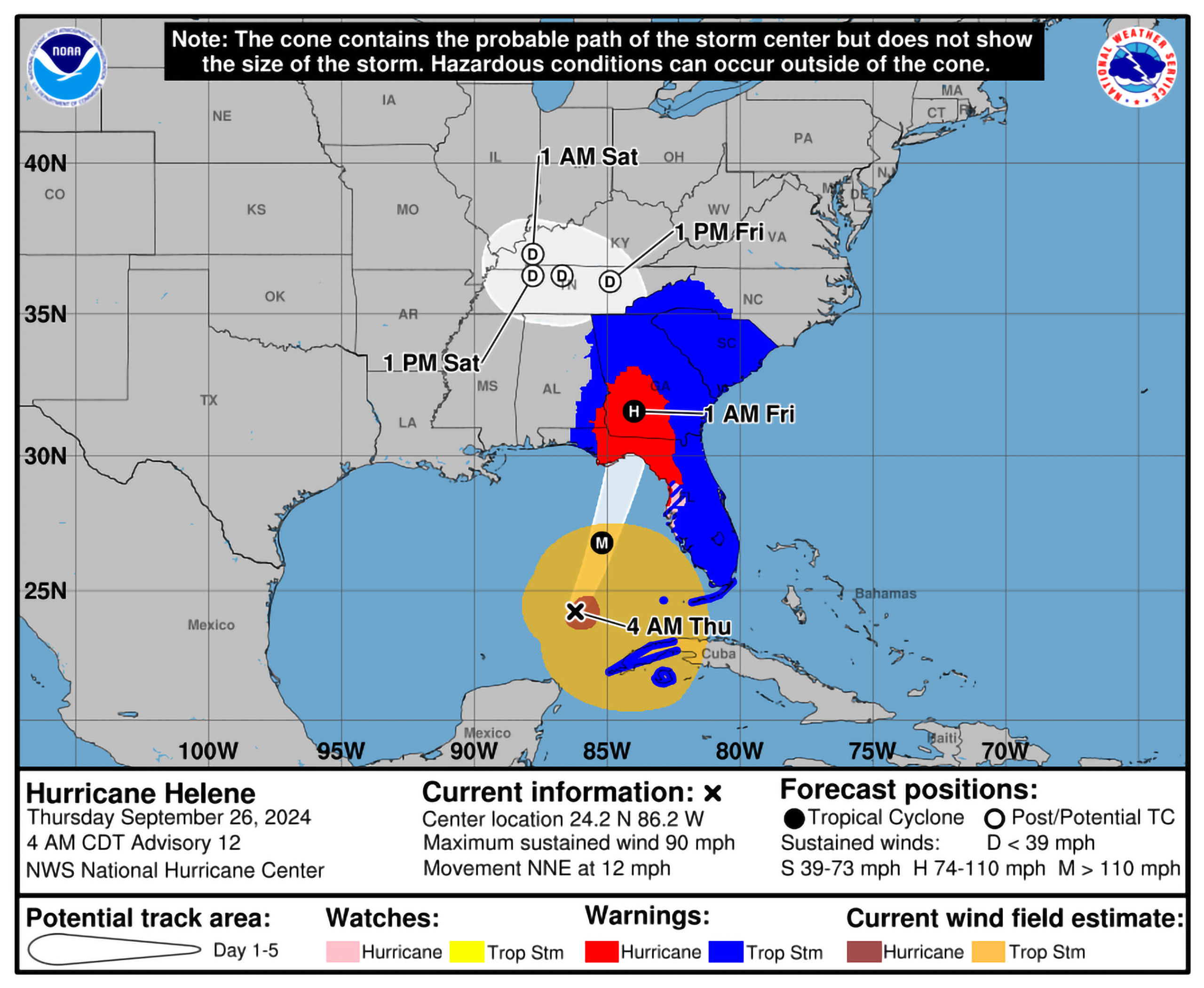
LOCATION...24.5N 85.9W
ABOUT 320 MI...515 KM SW OF TAMPA FLORIDA
ABOUT 365 MI...585 KM S OF APALACHICOLA FLORIDA
MAXIMUM SUSTAINED WINDS...100 MPH...155 KM/H
PRESENT MOVEMENT...NNE OR 15 DEGREES AT 12 MPH...19 KM/H
MINIMUM CENTRAL PRESSURE...960 MB...28.35 INCHES
WATCHES AND WARNINGS
--------------------
CHANGES WITH THIS ADVISORY:
None.
SUMMARY OF WATCHES AND WARNINGS IN EFFECT:
A Storm Surge Warning is in effect for...
* Mexico Beach eastward and southward to Flamingo
* Tampa Bay
* Charlotte Harbor
A Hurricane Warning is in effect for...
* Anclote River to Mexico Beach
A Hurricane Watch is in effect for...
* Englewood to Anclote River, including Tampa Bay
A Tropical Storm Warning is in effect for...
* Florida Keys, including the Dry Tortugas
* Flamingo to Anclote River, including Tampa Bay
* West of Mexico Beach to the Okaloosa/Walton County Line
* Flamingo northward to Little River Inlet
* Lake Okeechobee
* Cuban provinces of Artemisa, Pinar del Rio, and the Isle of Youth
A Storm Surge Warning means there is a danger of life-threatening
inundation, from rising water moving inland from the coastline. For
a depiction of areas at risk, please see the National Weather
Service Storm Surge Watch/Warning Graphic, available at
hurricanes.gov. This is a life-threatening situation. Persons
located within these areas should take all necessary actions to
protect life and property from rising water and the potential for
other dangerous conditions. Promptly follow evacuation and other
instructions from local officials.
A Hurricane Warning means that hurricane conditions are expected
somewhere within the warning area. Preparations to protect life
and property should be rushed to completion.
A Tropical Storm Warning means that tropical storm conditions are
expected somewhere within the warning area.
A Storm Surge Watch means there is a possibility of life-
threatening inundation, from rising water moving inland from the
coastline. For a depiction of areas at risk, please see the
National Weather Service Storm Surge Watch/Warning Graphic,
available at hurricanes.gov.
A Hurricane Watch means that hurricane conditions are possible
within the watch area.
For storm information specific to your area in the United
States, including possible inland watches and warnings, please
monitor products issued by your local National Weather Service
forecast office. For storm information specific to your area
outside of the United States, please monitor products issued by
your national meteorological service.
DISCUSSION AND OUTLOOK
----------------------
At 700 AM CDT (1200 UTC), the center of Hurricane Helene was located
near latitude 24.5 North, longitude 85.9 West. Helene is moving
toward the north-northeast near 12 mph (19 km/h). This general
motion is expected to continued with a significant increase in
forward speed during the next 24 hours. On the forecast track,
Helene will move across the eastern Gulf of Mexico today and cross
the Florida Big Bend coast this evening or early Friday morning.
After landfall, Helene is expected to turn northwestward and slow
down over the Tennessee Valley on Friday and Saturday.
Maximum sustained winds have increased to near 100 mph (155 km/h)
with higher gusts. Additional strengthening is forecast, and Helene
is expected to be a major hurricane when it reaches the Florida Big
Bend coast this evening. Weakening is expected after landfall, but
Helene's fast forward speed will allow strong, damaging winds,
especially in gusts, to penetrate well inland across the
southeastern United States, including over the higher terrain of the
southern Appalachians.
Hurricane-force winds extend outward up to 60 miles (95 km) from
the center and tropical-storm-force winds extend outward up to 345
miles (555 km). The Key West Naval Air Station recently reported
sustained winds of 41 mph (66 km/h) and a wind gust of 55 mph (89
km/h). An observation in Sand Key recently reported sustained
winds of 45 mph (72 km/h) and a gust to 58 mph (93 km/h).
The estimated minimum central pressure based on data from the
NOAA and Air Force Reserve Hurricane Hunter aircraft is 960 mb
(28.35 inches).
HAZARDS AFFECTING LAND
----------------------
Key Messages for Helene can be found in the Tropical Cyclone
Discussion under AWIPS header MIATCDAT4 and WMO header WTNT44 KNHC
and on the web at hurricanes.gov/text/MIATCDAT4.shtml
STORM SURGE: The combination of a life-threatening storm surge and
the tide will cause normally dry areas near the coast to be flooded
by rising waters moving inland from the shoreline. The water could
reach the following heights above ground somewhere in the indicated
areas if the peak surge occurs at the time of high tide...
Carrabelle, FL to Suwannee River, FL...15-20 ft
Apalachicola, FL to Carrabelle, FL...10-15 ft
Suwannee River, FL to Chassahowitzka, FL...10-15 ft
Chassahowitzka, FL to Anclote River, FL...8-12 ft
Indian Pass, FL to Apalachicola, FL...6-10 ft
Anclote River, FL to Middle of Longboat Key, FL...5-8 ft
Tampa Bay...5-8 ft
Middle of Longboat Key, FL to Englewood, FL...4-7 ft
East of Mexico Beach, FL to Indian Pass, FL...3-5 ft
Englewood, FL to Flamingo, FL...3-5 ft
Charlotte Harbor...3-5 ft
For a complete depiction of areas at risk of storm surge inundation,
please see the National Weather Service Peak Storm Surge Graphic,
available at hurricanes.gov/graphics_at4.shtml?peakSurge.
Storm surge could raise water levels by as much as 2 to 4 feet above
normal tide levels in areas of onshore winds along the southern
coast of Pinar del Rio, Cuba, including the Isle of Youth.
WIND: Hurricane conditions are expected within the U.S. hurricane
warning area late today. Tropical storm conditions have
already begun in the Florida Keys and portions of south
Florida, and these conditions are expected to spread northward
across the state and into Georgia and South Carolina through
tonight.
Tropical storm conditions are expected over portions of the warning
area in western Cuba during the next few hours.
RAINFALL: Hurricane Helene is expected to produce total rain
accumulations of 4 to 8 inches over western Cuba, the Cayman Islands
and the northeast Yucatan Peninsula, with isolated totals around 12
inches. This rainfall brings a risk of considerable flooding.
Over portions of the Southeastern U.S. into the Southern
Appalachians, Helene is expected to produce total rain accumulations
of 6 to 12 inches with isolated totals around 18 inches. This
rainfall will likely result in catastrophic and potentially
life-threatening flash and urban flooding, along with significant
river flooding. Numerous landslides are expected in steep terrain
across the southern Appalachians.
For a complete depiction of forecast rainfall associated with
Hurricane Helene, please see the National Weather Service Storm
Total Rainfall Graphic, available at
hurricanes.gov/graphics_at4.shtml?rainqpf and the Flash Flood Risk
graphic at hurricanes.gov/graphics_at4.shtml?ero.
TORNADOES: The risk for several tornadoes will gradually increase
today through tonight. The greatest threat is expected from parts of
northern Florida into southeast Georgia, the Midlands and Low
Country of South Carolina, and southern North Carolina.
SURF: Swells generated by Helene will affect much of Florida and
the coasts of Georgia and the Carolinas during the next couple of
days. Swells will also continue across portions of Cuba and the
Yucatan Peninsula through tonight. These swells are likely to cause
life-threatening surf and rip current conditions. Please consult
products from your local weather office.
NEXT ADVISORY
-------------
Next complete advisory at 1000 AM CDT.
$$
Forecaster CangialosiGood news is I was wrong, she didn't rapidly intensify over night. Still has a pretty large wing field, so unless that starts to shrink, she won't boom. Sounds like Cat 4 might be off the table, but she is over the incredibly warm, shallow, water of the Gulf, so anything is possible


This is in the keys right now

Disclosure; I am refeeding it on my parks channel from my weather one too, so its a switched feed setup.
Disclosure; I am refeeding it on my parks channel from my weather one too, so its a switched feed setup.
Why is Disney not stepping up and announcing an early closing time today? 5pm? 6pm? Not only for guest safety but to also allow CM's to safely get home, after having to secure the park?
Same reason why Universal hasn't called off Halloween Horror Nights yet and they would be open till 2am.
Register on WDWMAGIC. This sidebar will go away, and you'll see fewer ads.