News Walt Disney World is Under a Tornado Watch until 7PM

Gringrinngghost

Well-Known Member
Original Poster
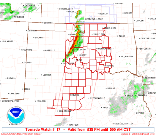
A tornado watch is now in effect for Orange County, which includes Walt Disney World and the theme park areas.

The advisory is in effect until Seven PM today.

What is the difference between a Tornado Watch and a Tornado Warning issued by the National Weather Service?
Tornado Watch: Be Prepared! Tornadoes are possible in and near the watch area. Review and discuss your emergency plans and check supplies and your safe room. Be ready to act quickly if a warning is issued or you suspect a tornado is approaching. Acting early helps to save lives! Watches are issued by the Storm Prediction Center for counties where tornadoes may occur. The watch area is typically large, covering numerous counties or even states.

Tornado Warning: Take Action! A tornado has been sighted or indicated by weather radar. There is imminent danger to life and property. Move to an interior room on the lowest floor of a sturdy building. Avoid windows. If in a mobile home, a vehicle, or outdoors, move to the closest substantial shelter and protect yourself from flying debris. Warnings are issued by your local forecast office. Warnings typically encompass a much smaller area (around the size of a city or small county) that may be impacted by a tornado identified by a forecaster on Radar or by a trained spotter/law enforcement who is watching the storm.
 

Gringrinngghost

Well-Known Member
Original Poster
Code:
 URGENT - IMMEDIATE BROADCAST REQUESTED
   Tornado Watch Number 17
   NWS Storm Prediction Center Norman OK
   1020 AM EDT Tue Mar 20 2018

   The NWS Storm Prediction Center has issued a

   * Tornado Watch for portions of
     Northern and central Florida
     Far southeast Georgia
     Coastal Waters

   * Effective this Tuesday morning and evening from 1020 AM until
     700 PM EDT.

   * Primary threats include...
     A few tornadoes likely with a couple intense tornadoes possible
     Scattered large hail likely with isolated very large hail events
       to 2.5 inches in diameter possible
     Scattered damaging wind gusts to 70 mph likely

   SUMMARY...Scattered severe storms are expected through this
   afternoon, capable of producing tornadoes, large hail, and damaging
   winds.

   The tornado watch area is approximately along and 75 statute miles
   either side of a line from 60 miles west northwest of Jacksonville
   FL to 35 miles west southwest of Avon Park FL. For a complete
   depiction of the watch see the associated watch outline update
   (WOUS64 KWNS WOU7).

   PRECAUTIONARY/PREPAREDNESS ACTIONS...

   REMEMBER...A Tornado Watch means conditions are favorable for
   tornadoes and severe thunderstorms in and close to the watch
   area. Persons in these areas should be on the lookout for
   threatening weather conditions and listen for later statements
   and possible warnings.

   &&

   AVIATION...Tornadoes and a few severe thunderstorms with hail
   surface and aloft to 2.5 inches. Extreme turbulence and surface wind
   gusts to 60 knots. A few cumulonimbi with maximum tops to 500. Mean
   storm motion vector 26035.

ww0017_radar.gif


Code:
WT 0017
PROBABILITY TABLE:
PROB OF 2 OR MORE TORNADOES                        :  70%
PROB OF 1 OR MORE STRONG /F2-F5/ TORNADOES         :  50%
PROB OF 10 OR MORE SEVERE WIND EVENTS              :  60%
PROB OF 1 OR MORE WIND EVENTS >= 65 KNOTS          :  20%
PROB OF 10 OR MORE SEVERE HAIL EVENTS              :  60%
PROB OF 1 OR MORE HAIL EVENTS >= 2 INCHES          :  50%
PROB OF 6 OR MORE COMBINED SEVERE HAIL/WIND EVENTS :  90%

&&
ATTRIBUTE TABLE:
MAX HAIL /INCHES/                            : 2.5
MAX WIND GUSTS SURFACE /KNOTS/               : 60
MAX TOPS /X 100 FEET/                        : 500
MEAN STORM MOTION VECTOR /DEGREES AND KNOTS/ : 26035
PARTICULARLY DANGEROUS SITUATION             : NO
 

Gringrinngghost

Well-Known Member
Original Poster
Today's Hazardous Weather Outlook:

Code:
THIS HAZARDOUS WEATHER OUTLOOK IS FOR EAST CENTRAL FLORIDA.

.DAY ONE...TODAY AND TONIGHT.

.THUNDERSTORM IMPACT...

...Enhanced Threat of Severe Weather Across East Central Florida
This Afternoon and Evening...

...Tornado Watch until 7 pm EDT for Lake, Volusia, Seminole, Orange,
Osceola and Brevard Counties...

A squall line is expected to develop ahead of a cold front and move
into areas northwest of I-4 early this afternoon. Ahead of this
line, a few strong to severe storms will continue to form and
push across the northern sections through early afternoon.

The line will push southward with a potential secondary band of
showers and storms farther south over the Gulf moving rapidly
eastward. This will lead to numerous showers and storms pushing
quickly toward the east-northeast across east central Florida around
55 to 60 mph through mid to late afternoon. This activity will then
shift south and offshore of the Treasure Coast by late evening.

Strong to severe storms will occur with this activity. Damaging wind
gusts up to 60 to 70 mph and frequent lightning strikes will be the
main threat from any severe storms, but large hail and isolated
tornadoes will also be possible. Make sure you have a way of
receiving timely severe weather watches and warnings for your area.

.HIGH WIND IMPACT...
Southwest winds will increase up to 20 to 25 mph into the
afternoon with frequent gusts up to 35 mph. A Lake Wind Advisory
is in effect this afternoon through early evening for all of east
central Florida.

.RIP CURRENT IMPACT...
A Moderate Risk of rip currents will exist along the beaches of
east central Florida today. Make sure to swim near a lifeguard
and be alert and prepared to take cover for any fast moving strong
to severe storms that cross the beaches and push offshore.

.MARINE THUNDERSTORM GUST IMPACT...
Scattered to numerous fast moving storms, pushing rapidly to the
east-northeast up to 50 to 60 knots and offshore through the
afternoon hours are expected across the area. Some storms may be
severe, producing wind gusts up to 60 knots.

.WATERSPOUT IMPACT...
Storms pushing offshore through this afternoon and evening will have
the potential to produce isolated waterspouts over the intracoastal
and adjacent Atlantic waters.

.WIND AND SEA IMPACT...
Southwest winds up to 15 to 20 knots over the waters today will
become westerly and increase to around 20 to 25 knots tonight,
with frequent gusts to gale force expected over the offshore
waters of Volusia and Brevard counties. A Small Craft Advisory
goes into effect this afternoon for the entire coastal waters,
with a Gale Warning in effect offshore, north of Sebastian inlet,
into tonight.

Some Impressive Cells has already fired.
Screen Shot 2018-03-20 at 10.51.44 AM.png
 

JohnD

Well-Known Member
Youza, I think that's a rare issue. So does WDW do anything different when its a watch (and not a warning)

Watches are in a huge swatch of land. I would say CMs are to be vigilant and ready to engage to tornado warning procedures if called upon. Among other things, they would probably close outside rides if thunderstorms are looking pretty imminent.
 

larryz

I'm Just A Tourist!
Premium Member
Youza, I think that's a rare issue. So does WDW do anything different when its a watch (and not a warning)
We left DHS one afternoon in a pounding, windy storm that soaked us to the skin. Found out listening to the radio on the drive home that the whole Orlando area was under a tornado watch at the time... no clue while in the park.

That wouldn't happen today, since everybody's got a little weather station in their pockets.
 

smile

Well-Known Member
I kick myself in the behind for not pursuing a career in meteorology like I had planned.

always been fascinated by weather and weather phenomena...
there's still so much we're unsure of and we've been staring up there for millenia - super interesting

can only imagine how much i would have liked a weather pavilion at ec :eek:
 

Winter

Well-Known Member
What would even happen if a tornado hit Disney World? Would it just be fairly minor damage (sorta like what hurricane irma did last year), or would it destroy the whole park?
 

smile

Well-Known Member
What would even happen if a tornado hit Disney World? Would it just be fairly minor damage (sorta like what hurricane irma did last year), or would it destroy the whole park?

that would be entirely dependent on tornado strength and, of course, location/touch-down - many tornados, especially in fl, don't touch earth...
regardless, a weaker tornado would be equivalent to hurricane winds, while a strong tornado can/may/will demolish anything it rolls over - made by humans or not
 

docdebbi

Well-Known Member
So now I'm curious. Who knows what disney's tornado plan is? I don't see them having a way to get folks to a safe place in adequate time if one really was sighted heading for them.
 

Andrew C

You know what's funny?
So now I'm curious. Who knows what disney's tornado plan is? I don't see them having a way to get folks to a safe place in adequate time if one really was sighted heading for them.

I doubt they have a specific tornado plan. Probably more likely is that they have procedures specific to bad weather events. I am sure some current or former CMs can shed some light.
 

Driver

Well-Known Member
I doubt they have a specific tornado plan. Probably more likely is that they have procedures specific to bad weather events. I am sure some current or former CMs can shed some light.
In the case of MK they have the utilidors if/when you go back stage the doors have signs on them with emergency info on them. It would be a mess but when lives are at stake the utilidors can hold a lot of people. Other seasoned CM friends of mine have told me there were a few ( rare) cases when that plan was put into action.
 

Register on WDWMAGIC. This sidebar will go away, and you'll see fewer ads.

Back
Top Bottom