News Tropical Storm Nicole impacts to Walt Disney World - November 2022

lazyboy97o

Well-Known Member
Well the good news is that this will definitely not be another Hurricane Ian. Just some strong winds and rain.
The are still areas with saturated ground and high water from Ian. Retention ponds are still high, and some detention ponds still carry water. In some places the waters peaked weeks later and are only now starting to recede. Seminole Blvd in Sanford along Lake Monroe is still closed. Lake Jesup is still high with several feet of water in lakeside houses.
 

JoeCamel

Well-Known Member
The are still areas with saturated ground and high water from Ian. Retention ponds are still high, and some detention ponds still carry water. In some places the waters peaked weeks later and are only now starting to recede. Seminole Blvd in Sanford along Lake Monroe is still closed. Lake Jesup is still high with several feet of water in lakeside houses.
How is Okeechobee doing, will it flush out to the ocean?
 

Prince-1

Well-Known Member
The are still areas with saturated ground and high water from Ian. Retention ponds are still high, and some detention ponds still carry water. In some places the waters peaked weeks later and are only now starting to recede. Seminole Blvd in Sanford along Lake Monroe is still closed. Lake Jesup is still high with several feet of water in lakeside houses.

I didn't say that it would be all roses and sunshine but it most definitely won't be another Ian.
 

vikescaper

Well-Known Member
My sister and I have plans to be at Disney Springs to watch Wakanda Forever on Thursday. We have made backup plans in case we don’t make it due to the weather.
 

CJR

Well-Known Member
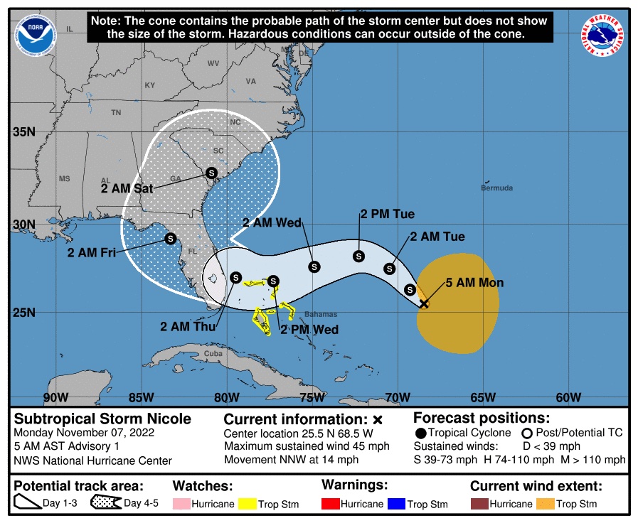
It's a pretty bizarre track. Can't think of a storm in the last decade that hit from the eastern side. We'll definitely have to watch this one.

The good news is the rain predictions seem low. Showing a couple inches total over here. Could change, but at least it's not another Ian.
 

wdwmagic

Administrator
Moderator
Premium Member
Original Poster
FLZ045-080000-
/O.NEW.KMLB.TR.A.1017.221107T1516Z-000000T0000Z/
Orange-
1016 AM EST Mon Nov 7 2022

...TROPICAL STORM WATCH IN EFFECT...

A Tropical Storm Watch means tropical storm-force winds are possible
somewhere within this area within the next 48 hours

* WIND
- LATEST LOCAL FORECAST: Equivalent Tropical Storm force wind
- Peak Wind Forecast: 40-50 mph with gusts to 65 mph
- Window for Tropical Storm force winds: Wednesday evening
until Thursday afternoon

- THREAT TO LIFE AND PROPERTY THAT INCLUDES TYPICAL FORECAST
UNCERTAINTY IN TRACK, SIZE AND INTENSITY: Potential for wind 39
to 57 mph
- PLAN: Plan for hazardous wind of equivalent tropical storm
force.
- PREPARE: Efforts to protect property should now be
underway. Prepare for limited wind damage.
- ACT: Act now to complete preparations before the wind
becomes hazardous.

- POTENTIAL IMPACTS: Limited
- Damage to porches, awnings, carports, sheds, and unanchored
mobile homes. Unsecured lightweight objects blown about.
- Many large tree limbs broken off. A few trees snapped or
uprooted, but with greater numbers in places where trees
are shallow rooted. Some fences and roadway signs blown
over.
- A few roads impassable from debris, particularly within
urban or heavily wooded places. Hazardous driving
conditions on bridges and other elevated roadways.
- Scattered power and communications outages.

* FLOODING RAIN
- LATEST LOCAL FORECAST:
- Peak Rainfall Amounts: 3-6 inches, with locally higher
amounts

- THREAT TO LIFE AND PROPERTY THAT INCLUDES TYPICAL FORECAST
UNCERTAINTY IN TRACK, SIZE AND INTENSITY: Potential for
moderate flooding rain
- PLAN: Emergency plans should include the potential for
moderate flooding from heavy rain. Evacuations and rescues
are possible.
- PREPARE: Consider protective actions if you are in an area
vulnerable to flooding.
- ACT: Heed any flood watches and warnings. Failure to take
action may result in serious injury or loss of life.

- POTENTIAL IMPACTS: Significant
- Moderate rainfall flooding may prompt several evacuations
and rescues.
- Rivers and tributaries may quickly become swollen with
swifter currents and overspill their banks in a few places,
especially in usually vulnerable spots. Small streams,
creeks, canals, and ditches overflow.
- Flood waters can enter some structures or weaken
foundations. Several places may experience expanded areas
of rapid inundation at underpasses, low-lying spots, and
poor drainage areas. Some streets and parking lots take on
moving water as storm drains and retention ponds overflow.
Driving conditions become hazardous. Some road and bridge
closures.

* TORNADO
- LATEST LOCAL FORECAST:
- Situation is somewhat favorable for tornadoes

- THREAT TO LIFE AND PROPERTY THAT INCLUDES TYPICAL FORECAST
UNCERTAINTY IN TRACK, SIZE AND INTENSITY: Potential for a few
tornadoes
- PLAN: Emergency plans should include the potential for a
few tornadoes.
- PREPARE: If your shelter is particularly vulnerable to
tornadoes, prepare to relocate to safe shelter before
hazardous weather arrives.
- ACT: If a tornado warning is issued, be ready to shelter
quickly.

- POTENTIAL IMPACTS: Limited
- The occurrence of isolated tornadoes can hinder the
execution of emergency plans during tropical events.
- A few places may experience tornado damage, along with
power and communications disruptions.
- Locations could realize roofs peeled off buildings,
chimneys toppled, mobile homes pushed off foundations or
overturned, large tree tops and branches snapped off,
shallow-rooted trees knocked over, moving vehicles blown
off roads, and small boats pulled from moorings.
 

JohnD

Well-Known Member
Here's the live map (updated every three hours by NHC)
1667838900399.png
 

JoeCamel

Well-Known Member
Weird spaghetti model, does a 180 and goes back over the state

A front will collide and turn it back out letting the Eastern Seaboard get in on all the fun.
 

Zummi Gummi

Pioneering the Universe Within!
Some yucky weather in store on Thursday, maybe into early Friday.

Some people in my office are already losing their minds, of course. This is not another Ian, and some folks need to relax.
 

JohnD

Well-Known Member
Weird spaghetti model, does a 180 and goes back over the state

That's because of the rain front working it's way from Texas eastward. The storm will hit the front and be pushed back to the northeast.
 

Register on WDWMAGIC. This sidebar will go away, and you'll see fewer ads.

Back
Top Bottom