-
Welcome to the WDWMAGIC.COM Forums!
Please take a look around, and feel free to sign up and join the community.
You are using an out of date browser. It may not display this or other websites correctly.
You should upgrade or use an alternative browser.
You should upgrade or use an alternative browser.
Potential Major Hurricane Idalia Possibly to Impact Central/Northern Florida 8/29
- Thread starter monothingie
- Start date
Gringrinngghost
Well-Known Member
Hurricane Watches are up for parts of Florida.
Code:
000
WTNT35 KNHC 272050
TCPAT5

BULLETIN
Tropical Storm Idalia Advisory Number   5
NWS National Hurricane Center Miami FL       AL102023
400 PM CDT Sun Aug 27 2023

...STORM SURGE AND HURRICANE WATCHES ISSUED FOR PORTIONS OF THE
FLORIDA GULF COAST...


SUMMARY OF 400 PM CDT...2100 UTC...INFORMATION
----------------------------------------------
LOCATION...20.1N 85.5W
ABOUT 95 MI...155 KM ESE OF COZUMEL MEXICO
MAXIMUM SUSTAINED WINDS...40 MPH...65 KM/H
PRESENT MOVEMENT...NE OR 40 DEGREES AT 3 MPH...6 KM/H
MINIMUM CENTRAL PRESSURE...995 MB...29.39 INCHES


WATCHES AND WARNINGS
--------------------
CHANGES WITH THIS ADVISORY:

A Storm Surge Watch has been issued for the Gulf coast of Florida
from Chokoloskee to Indian Pass, including Tampa Bay.

A Hurricane Watch has been issued for the Gulf coast of Florida
from Englewood to Indian Pass, including Tampa Bay.

A Tropical Storm Watch has been issued for the Gulf coast of
Florida south of Englewood to Chokoloskee, and for the Dry Tortugas.

SUMMARY OF WATCHES AND WARNINGS IN EFFECT:

A Tropical Storm Warning is in effect for...
* Yucatan Peninsula from Tulum to Rio Lagartos, including Cozumel
* Pinar del Rio Cuba

A Storm Surge Watch is in effect for...
* Chokoloskee to Indian Pass Florida, including Tampa Bay

A Hurricane Watch is in effect for...
* Englewood to Indian Pass Florida, including Tampa Bay

A Tropical Storm Watch is in effect for...
* Isle of Youth Cuba
* South of Englewood to Chokoloskee Florida
* Dry Tortugas Florida

A Storm Surge Watch means there is a possibility of life-
threatening inundation, from rising water moving inland from the
coastline, in the indicated locations during the next 48 hours.
For a depiction of areas at risk, please see the National Weather
Service Storm Surge Watch/Warning Graphic, available at
hurricanes.gov.

A Hurricane Watch means that hurricane conditions are possible
within the watch area.  A watch is typically issued 48 hours
before the anticipated first occurrence of tropical-storm-force
winds, conditions that make outside preparations difficult or
dangerous.

A Tropical Storm Warning means that tropical storm conditions are
expected somewhere within the warning area.

A Tropical Storm Watch means that tropical storm conditions are
possible within the watch area.

Interests along the southeastern U.S. coast should monitor the
progress of this system.  Additional watches and warnings will
likely be required on Monday.

For storm information specific to your area, please monitor
products issued by your national meteorological service.


DISCUSSION AND OUTLOOK
----------------------
At 400 PM CDT (2100 UTC), the center of Tropical Storm Idalia was
located near latitude 20.1 North, longitude 85.5 West.  Idalia is
moving toward the northeast near 3 mph (6 km/h).  A slow, possibly
erratic, motion is expected overnight.  A generally northward to
north-northeastward motion at an increasing forward speed is
expected on Monday and Tuesday.  On the forecast track, the center
will move over the eastern Gulf of Mexico on Monday and Tuesday,
and approach the northeast Gulf coast late Tuesday.

Maximum sustained winds are near 40 mph (65 km/h) with higher gusts.
Strengthening is forecast, and Idalia is expected to become a
hurricane over the southeastern Gulf of Mexico by early Tuesday.
Additional strengthening is likely while Idalia approaches the
northeastern Gulf coast.

Tropical-storm-force winds extend outward up to 70 miles (110 km)
from the center.

The estimated minimum central pressure is 995 mb (29.39 inches).


HAZARDS AFFECTING LAND
----------------------
Key messages for Idalia can be found in the Tropical Cyclone
Discussion under AWIPS header MIATCDAT5 and WMO header WTNT45 KNHC,
and on the web at hurricanes.gov/text/MIATCDAT5.shtml

STORM SURGE:  The combination of a dangerous storm surge and the
tide will cause normally dry areas near the coast to be flooded by
rising waters moving inland from the shoreline.  The water could
reach the following heights above ground somewhere in the indicated
areas if the peak surge occurs at the time of high tide...

Aucilla River, FL to Chassahowitzka, FL...7-11 ft
Chassahowitzka, FL to Anclote River, FL...5-8 ft
Ochlockonee River, FL to Aucilla River, FL...4-7 ft
Anclote River, FL to Middle of Longboat Key, FL...3-5 ft
Tampa Bay...3-5 ft
Middle of Longboat Key, FL to Chokoloskee, FL...2-4 ft
Charlotte Harbor...2-4 ft
Indian Pass, FL to Ochlockonee River, FL...2-4 ft
Chokoloskee, FL to East Cape Sable, FL...1-3 ft
Florida Keys...1-2 ft

The deepest water will occur along the immediate coast in areas of
onshore winds, where the surge will be accompanied by large and
dangerous waves.  Surge-related flooding depends on the relative
timing of the surge and the tidal cycle, and can vary greatly over
short distances.  For information specific to your area, please see
products issued by your local National Weather Service forecast
office.

Storm surge will raise water levels by as much as 2 to 4 feet above
normal tide levels along the southern coast of Pinar del Rio, Cuba.
Near the coast, the surge will be accompanied by
large waves.

WIND:  Tropical storm conditions are expected over portions of the
warning area over the Yucatan Peninsula and western Cuba through
Monday.  Tropical storm conditions are possible within the watch
area on the Isle of Youth on Monday.

Hurricane conditions are possible within the hurricane watch area by
late Tuesday or Wednesday, with tropical storm conditions possible
by Tuesday.

Tropical storm conditions are possible in the Dry Tortugas beginning
late Monday and within the tropical storm watch area along the
Florida Gulf coast on Tuesday.

RAINFALL:  Idalia is expected to produce the following rainfall
amounts:

Portions of the eastern Yucatan Peninsula: 2 to 4 inches, with
isolated higher totals of 6 inches.

Western Cuba: 3 to 6 inches, with isolated higher totals of 10
inches.

Portions of the west coast of Florida, the Florida Panhandle, and
southern Georgia: From Tuesday into Wednesday, 3 to 6 inches, with
isolated higher totals of 10 inches.

Heavy rainfall is also likely to spread into portions of the
Carolinas by Wednesday into Thursday.

This rainfall may lead to flash and urban flooding, and landslides
across western Cuba.  Scattered flash and urban flooding can also
be expected across portions of the west coast of Florida, the
Florida Panhandle and portions of the Southeast U.S. by Tuesday
into Thursday.


NEXT ADVISORY
-------------
Next intermediate advisory at 700 PM CDT.
Next complete advisory at 1000 PM CDT.

$$
Forecaster PaschGringrinngghost
Well-Known Member
SamusAranX
Well-Known Member
So is Disney closing or they don’t announce until day before?
Figgy1
Well-Known Member
probably not unless the forecast changes. 24 to 36 hours in advance is sop. This is all subject to change depending on what happens in the gulf. Hurricane change/cancellation procedures happen sooner sometimesSo is Disney closing or they don’t announce until day before?
Unlikely, the most foreseeable effect could be operational alterations to the MNSSHP or a very unlikely cancellation.So is Disney closing or they don’t announce until day before?
8/30 will be a lousy morning, but the storm is a fast mover and will be well gone before late afternoon.
Agreed, it takes a near-hit from a powerful storm to close the parks. Or a storm like Ian moving within 60 miles of the parks.Unlikely, the most foreseeable effect could be operational alterations to the MNSSHP or a very unlikely cancellation.
8/30 will be a lousy morning, but the storm is a fast mover and will be well gone before late afternoon.
hopemax
Well-Known Member
Donut King... just outside the edge.View attachment 739401
This is the current far right edge of the cone
My Dad should get what he wants, enough water to fill the pool back up... he's been trying to hold off.
ChrisFL
Premium Member
In preparation, Epcot is going to open Moana: Journey of a whole lot of waterSo is Disney closing or they don’t announce until day before?
Gringrinngghost
Well-Known Member
It’s going to be a Category 3 at landfall now early Wednesday Morning on the gulf coast near Gainesville.

Code:
ZCZC MIATCPAT5 ALL
TTAA00 KNHC DDHHMM

BULLETIN
Tropical Storm Idalia Advisory Number   7
NWS National Hurricane Center Miami FL       AL102023
400 AM CDT Mon Aug 28 2023

...IDALIA INTENSIFYING AS IT APPROACHES CUBA...
...LIFE-THREATENING STORM SURGE AND DANGEROUS WINDS BECOMING
INCREASINGLY LIKELY FOR PORTIONS OF FLORIDA...


SUMMARY OF 400 AM CDT...0900 UTC...INFORMATION
----------------------------------------------
LOCATION...20.1N 85.2W
ABOUT 125 MI...200 KM S OF THE WESTERN TIP OF CUBA
MAXIMUM SUSTAINED WINDS...65 MPH...100 KM/H
PRESENT MOVEMENT...N OR 360 DEGREES AT 7 MPH...11 KM/H
MINIMUM CENTRAL PRESSURE...989 MB...29.21 INCHES


WATCHES AND WARNINGS
--------------------
CHANGES WITH THIS ADVISORY:

None.

SUMMARY OF WATCHES AND WARNINGS IN EFFECT:

A Hurricane Warning is in effect for...
* Pinar del Rio Cuba

A Tropical Storm Warning is in effect for...
* Yucatan Peninsula from Tulum to Rio Lagartos, including Cozumel
* Isle of Youth Cuba
* Dry Tortugas Florida

A Storm Surge Watch is in effect for...
* Chokoloskee to Indian Pass Florida, including Tampa Bay

A Hurricane Watch is in effect for...
* Englewood to Indian Pass Florida, including Tampa Bay

A Tropical Storm Watch is in effect for...
* South of Englewood to Chokoloskee Florida
* Lower Florida Keys west of the west end of the Seven Mile Bridge

A Hurricane Warning means that hurricane conditions are expected
somewhere within the warning area, in this case within the next
12-24 hours.  Preparations to protect life and property should be
rushed to completion.

A Storm Surge Watch means there is a possibility of life-
threatening inundation, from rising water moving inland from the
coastline, in the indicated locations during the next 48 hours.
For a depiction of areas at risk, please see the National Weather
Service Storm Surge Watch/Warning Graphic, available at
hurricanes.gov.

A Hurricane Watch means that hurricane conditions are possible
within the watch area.

A Tropical Storm Warning means that tropical storm conditions are
expected somewhere within the warning area.

A Tropical Storm Watch means that tropical storm conditions are
possible within the watch area.

Interests along the southeastern U.S. coast should monitor the
progress of this system.  Additional watches and warnings will
likely be required later this morning.

For storm information specific to your area in the United
States, including possible inland watches and warnings, please
monitor products issued by your local National Weather Service
forecast office. For storm information specific to your area
outside of the United States, please monitor products issued by
your national meteorological service.


DISCUSSION AND OUTLOOK
----------------------
At 400 AM CDT (0900 UTC), the center of Tropical Storm Idalia was
located near latitude 20.1 North, longitude 85.2 West. Idalia is
moving toward the north near 7 mph (11 km/h), with a continued
northward motion bringing the center of Idalia near or over
western Cuba tonight and over the extreme southeastern Gulf of
Mexico by early Tuesday.  On the forecast track, Idalia is forecast
to increase in forward speed and turn north-northeastward over the
eastern Gulf of Mexico on Tuesday and reach the Gulf coast of
Florida on Wednesday.

Maximum sustained winds have increased to near 65 mph (100 km/h)
with higher gusts.  Idalia is forecast to become a hurricane later
today and a dangerous major hurricane over northeastern Gulf of
Mexico by early Wednesday.

Tropical-storm-force winds extend outward up to 70 miles (110 km)
from the center.

The estimated minimum central pressure is 989 mb (29.21 inches).


HAZARDS AFFECTING LAND
----------------------
Key messages for Idalia can be found in the Tropical Cyclone
Discussion under AWIPS header MIATCDAT5 and WMO header WTNT45 KNHC,
and on the web at hurricanes.gov/text/MIATCDAT5.shtml

STORM SURGE:  The combination of a dangerous storm surge and the
tide will cause normally dry areas near the coast to be flooded by
rising waters moving inland from the shoreline.  The water could
reach the following heights above ground somewhere in the indicated
areas if the peak surge occurs at the time of high tide...

Aucilla River, FL to Chassahowitzka, FL...7-11 ft
Chassahowitzka, FL to Anclote River, FL...6-9 ft
Ochlockonee River, FL to Aucilla River, FL...4-7 ft
Anclote River, FL to Middle of Longboat Key, FL...4-7 ft
Tampa Bay...4-7 ft
Middle of Longboat Key, FL to Englewood, FL...3-5 ft
Englewood, FL to Chokoloskee, FL...2-4 ft
Charlotte Harbor...2-4 ft
Indian Pass, FL to Ochlockonee River, FL...2-4 ft
Chokoloskee, FL to East Cape Sable, FL...1-3 ft
Florida Keys...1-2 ft

The deepest water will occur along the immediate coast in areas of
onshore winds, where the surge will be accompanied by large and
dangerous waves.  Surge-related flooding depends on the relative
timing of the surge and the tidal cycle, and can vary greatly over
short distances.  For information specific to your area, please see
products issued by your local National Weather Service forecast
office.

Storm surge will raise water levels by as much as 4 to 6 feet above
normal tide levels along the southern coast of Pinar del Rio, Cuba.
Near the coast, the surge will be accompanied by large waves.

WIND:  Hurricane conditions are expected within the hurricane
warning area in western Cuba later today.  Winds are expected to
first reach tropical storm strength by this morning, making
outside preparations difficult or dangerous.  Preparations to
protect life and property should be rushed to completion.

Tropical storm conditions are expected over portions of the
tropical storm warning area over the Yucatan Peninsula and the Isle
of Youth in Cuba through today

Hurricane conditions are possible within the hurricane watch area by
late Tuesday or Wednesday, with tropical storm conditions possible
by Tuesday.

Tropical storm conditions are possible in the Dry Tortugas beginning
late today and within the tropical storm watch area along the
Florida Gulf coast on Tuesday.

RAINFALL:  Idalia is expected to produce the following rainfall
amounts:

Portions of the eastern Yucatan: Additional 1 to 2 inches.

Western Cuba: 4 to 7 inches, with isolated higher totals of 10
inches.

Portions of the west coast of Florida, the Florida Panhandle,
southeast Georgia and the eastern Carolinas: 4 to 8 inches from
Tuesday into Thursday. Isolated higher totals of 12 inches possible,
primarily near landfall in northern Florida.

This rainfall may lead to flash and urban flooding, and landslides
across western Cuba.

Areas of flash and urban flooding, some of which may be locally
significant, are expected across portions of the west coast of
Florida, the Florida Panhandle, and southern Georgia Tuesday into
Wednesday, spreading into portions of the eastern Carolinas
Wednesday into Thursday.

SURF:  Swells generated by Idalia are affecting portions of the
southern coast of Cuba and eastern Yucatan.  These swells are
likely to cause life-threatening surf and rip current conditions.
Please consult products from your local weather office.


NEXT ADVISORY
-------------
Next intermediate advisory at 700 AM CDT.
Next complete advisory at 1000 AM CDT.

$$
Forecaster Blake

NNNNGringrinngghost
Well-Known Member
Walt DIsney World, Universal Orlando, Legoland SeaWorld Orlando, Gatorland are now under all under a Tropical Storm Watch.
Osceola:
Orange:
Tuesday night and Wednesday, Tropical Storm Conditions are possible for the Orlando Parks.
NOTE: As of the time of posting of 5:25am EDT there are currently no operational impacts.
CC: @wdwmagic
Osceola:
Code:
Tropical Storm Watch
Idalia Local Watch/Warning Statement/Advisory Number 7
National Weather Service Melbourne FL  AL102023
506 AM EDT Mon Aug 28 2023

FLZ053-281630-
/O.EXA.KMLB.TR.A.1010.000000T0000Z-000000T0000Z/
Osceola-
506 AM EDT Mon Aug 28 2023

...TROPICAL STORM WATCH IN EFFECT...

* WIND
    - LATEST LOCAL FORECAST: Tropical storm force winds possible
        - Peak Wind Forecast: 20-30 mph with gusts to 40 mph

    - THREAT TO LIFE AND PROPERTY THAT INCLUDES TYPICAL FORECAST
      UNCERTAINTY IN TRACK, SIZE AND INTENSITY: Potential for wind 58
      to 73 mph
        - The wind threat has remained nearly steady from the
          previous assessment.
        - PLAN: Plan for dangerous wind of equivalent strong tropical
          storm force.
        - PREPARE: Efforts to protect life and property should now be
          underway. Prepare for significant wind damage.
        - ACT: Act now to complete preparations before the wind
          becomes hazardous.

    - POTENTIAL IMPACTS: Significant
        - Some damage to roofing and siding materials, along with
          damage to porches, awnings, carports, and sheds. A few
          buildings experiencing window, door, and garage door
          failures. Mobile homes damaged, especially if unanchored.
          Unsecured lightweight objects become dangerous projectiles.
        - Several large trees snapped or uprooted, but with greater
          numbers in places where trees are shallow rooted. Several
          fences and roadway signs blown over.
        - Some roads impassable from large debris, and more within
          urban or heavily wooded places. A few bridges, causeways,
          and access routes impassable.
        - Scattered power and communications outages, but more
          prevalent in areas with above ground lines.

* FLOODING RAIN
    - LATEST LOCAL FORECAST:
        - Peak Rainfall Amounts: Additional 2-4 inches, with locally
          higher amounts

    - THREAT TO LIFE AND PROPERTY THAT INCLUDES TYPICAL FORECAST
      UNCERTAINTY IN TRACK, SIZE AND INTENSITY: Potential for
      localized flooding rain
        - The flooding rain threat has remained nearly steady from
          the previous assessment.
        - PLAN: Emergency plans should include the potential for
          localized flooding from heavy rain.
        - PREPARE: Consider protective actions if you are in an area
          vulnerable to flooding.
        - ACT: Heed any flood watches and warnings.

    - POTENTIAL IMPACTS: Limited
        - Localized rainfall flooding may prompt a few evacuations.
        - Rivers and tributaries may quickly rise with swifter
          currents. Small streams, creeks, canals, and ditches may
          become swollen and overflow in spots.
        - Flood waters can enter a few structures, especially in
          usually vulnerable spots. A few places where rapid ponding
          of water occurs at underpasses, low-lying spots, and poor
          drainage areas. Several storm drains and retention ponds
          become near-full and begin to overflow. Some brief road and
          bridge closures.

* TORNADO
    - LATEST LOCAL FORECAST:
        - Situation is somewhat favorable for tornadoes

    - THREAT TO LIFE AND PROPERTY THAT INCLUDES TYPICAL FORECAST
      UNCERTAINTY IN TRACK, SIZE AND INTENSITY: Potential for a few
      tornadoes
        - The tornado threat has increased from the previous
          assessment.
        - PLAN: Emergency plans should include the potential for a
          few tornadoes.
        - PREPARE: If your shelter is particularly vulnerable to
          tornadoes, prepare to relocate to safe shelter before
          hazardous weather arrives.
        - ACT: If a tornado warning is issued, be ready to shelter
          quickly.

    - POTENTIAL IMPACTS: Limited
        - The occurrence of isolated tornadoes can hinder the
          execution of emergency plans during tropical events.
        - A few places may experience tornado damage, along with
          power and communications disruptions.
        - Locations could realize roofs peeled off buildings,
          chimneys toppled, mobile homes pushed off foundations or
          overturned, large tree tops and branches snapped off,
          shallow-rooted trees knocked over, moving vehicles blown
          off roads, and small boats pulled from moorings.

$$
Orange:
Code:
Tropical Storm Watch
Idalia Local Watch/Warning Statement/Advisory Number 7
National Weather Service Melbourne FL  AL102023
506 AM EDT Mon Aug 28 2023

FLZ045-281630-
/O.EXA.KMLB.TR.A.1010.000000T0000Z-000000T0000Z/
Orange-
506 AM EDT Mon Aug 28 2023

...TROPICAL STORM WATCH IN EFFECT...

* WIND
    - LATEST LOCAL FORECAST: Tropical storm force winds possible
        - Peak Wind Forecast: 20-30 mph with gusts to 40 mph

    - THREAT TO LIFE AND PROPERTY THAT INCLUDES TYPICAL FORECAST
      UNCERTAINTY IN TRACK, SIZE AND INTENSITY: Potential for wind 58
      to 73 mph
        - The wind threat has remained nearly steady from the
          previous assessment.
        - PLAN: Plan for dangerous wind of equivalent strong tropical
          storm force.
        - PREPARE: Efforts to protect life and property should now be
          underway. Prepare for significant wind damage.
        - ACT: Act now to complete preparations before the wind
          becomes hazardous.

    - POTENTIAL IMPACTS: Significant
        - Some damage to roofing and siding materials, along with
          damage to porches, awnings, carports, and sheds. A few
          buildings experiencing window, door, and garage door
          failures. Mobile homes damaged, especially if unanchored.
          Unsecured lightweight objects become dangerous projectiles.
        - Several large trees snapped or uprooted, but with greater
          numbers in places where trees are shallow rooted. Several
          fences and roadway signs blown over.
        - Some roads impassable from large debris, and more within
          urban or heavily wooded places. A few bridges, causeways,
          and access routes impassable.
        - Scattered power and communications outages, but more
          prevalent in areas with above ground lines.

* FLOODING RAIN
    - LATEST LOCAL FORECAST:
        - Peak Rainfall Amounts: Additional 2-4 inches, with locally
          higher amounts

    - THREAT TO LIFE AND PROPERTY THAT INCLUDES TYPICAL FORECAST
      UNCERTAINTY IN TRACK, SIZE AND INTENSITY: Potential for
      moderate flooding rain
        - The flooding rain threat has increased from the previous
          assessment.
        - PLAN: Emergency plans should include the potential for
          moderate flooding from heavy rain. Evacuations and rescues
          are possible.
        - PREPARE: Consider protective actions if you are in an area
          vulnerable to flooding.
        - ACT: Heed any flood watches and warnings. Failure to take
          action may result in serious injury or loss of life.

    - POTENTIAL IMPACTS: Significant
        - Moderate rainfall flooding may prompt several evacuations
          and rescues.
        - Rivers and tributaries may quickly become swollen with
          swifter currents and overspill their banks in a few places,
          especially in usually vulnerable spots. Small streams,
          creeks, canals, and ditches overflow.
        - Flood waters can enter some structures or weaken
          foundations. Several places may experience expanded areas
          of rapid inundation at underpasses, low-lying spots, and
          poor drainage areas. Some streets and parking lots take on
          moving water as storm drains and retention ponds overflow.
          Driving conditions become hazardous. Some road and bridge
          closures.

* TORNADO
    - LATEST LOCAL FORECAST:
        - Situation is favorable for tornadoes

    - THREAT TO LIFE AND PROPERTY THAT INCLUDES TYPICAL FORECAST
      UNCERTAINTY IN TRACK, SIZE AND INTENSITY: Potential for several
      tornadoes
        - The tornado threat has increased from the previous
          assessment.
        - PLAN: Emergency plans should include the potential for
          several tornadoes with a few possibly intense having larger
          damage paths.
        - PREPARE: Those living in manufactured homes or on boats
          should prepare to relocate to safe shelter before hazardous
          weather arrives.
        - ACT: Listen for tornado watches and warnings. If a tornado
          warning is issued, be ready to shelter quickly.

    - POTENTIAL IMPACTS: Significant
        - The occurrence of scattered tornadoes can hinder the
          execution of emergency plans during tropical events.
        - Several places may experience tornado damage with a few
          spots of considerable damage, power loss, and
          communications failures.
        - Locations could realize roofs torn off frame houses, mobile
          homes demolished, boxcars overturned, large trees snapped
          or uprooted, vehicles tumbled, and small boats tossed
          about. Dangerous projectiles can add to the toll.

$$
Tuesday night and Wednesday, Tropical Storm Conditions are possible for the Orlando Parks.
NOTE: As of the time of posting of 5:25am EDT there are currently no operational impacts.
CC: @wdwmagic
Gringrinngghost
Well-Known Member
Code:
Tropical Storm Idalia Local Statement Advisory Number 7
FLZ041-044>046-053-058-141-144-154-159-164-247-254-259-264-347-447-547-647-747-281630-

Tropical Storm Idalia Local Statement Advisory Number 7
National Weather Service Melbourne FL  AL102023
534 AM EDT Mon Aug 28 2023


This product covers East Central Florida

**Tropical Storm Idalia Forecast to Strengthen into a Hurricane as
it Moves Into the Southeastern Gulf of Mexico Later Today**


NEW INFORMATION
---------------

* CHANGES TO WATCHES AND WARNINGS:
  - A Tropical Storm Watch has been issued for Orange, Osceola, and
    Seminole

* CURRENT WATCHES AND WARNINGS:
  - A Tropical Storm Watch is in effect for Northern Lake, Orange,
    Osceola, Seminole, and Southern Lake

* STORM INFORMATION:
  - About 640 miles south-southwest of Leesburg  FL
  - 20.1N 85.2W  - Storm Intensity 65 mph
  - Movement North or 360 degrees at 7 mph


SITUATION OVERVIEW
------------------

The center of Tropical Storm Idalia is located around 125 miles
south of the tip of western Cuba early this morning. Idalia is
moving north at about 7 mph, with a continued northward motion
expected today and Tuesday. The storm is currently forecast to
approach the Florida Gulf coast Tuesday night into Wednesday as a
major hurricane.
Preparations should be ongoing for at least tropical storm
conditions by mid week.

A Tropical Storm Watch is now in effect for Lake, Seminole, Orange
and Osceola Counties, where confidence is highest in tropical storm
conditions occurring. Additional watches may be necessary for
portions of east-central Florida later this morning.

Showers, squalls and thunderstorms associated with outer rain bands
from Idalia may reach central Florida by late this afternoon, with
conditions further deteriorating Tuesday afternoon and evening as
Idalia accelerates north-northeastward across the eastern Gulf of
Mexico. As coverage of showers and squalls increases Tuesday
afternoon into Wednesday, the possibility of strong to damaging wind
gusts will also increase. Tropical storm force winds are forecast to
extend outward from the storm`s center, potentially reaching
interior portions of east-central Florida Tuesday night into
Wednesday morning.
Based on the current forecast track, Idalia will make its closest
pass to east-central Florida late Tuesday night and early Wednesday
morning, continuing northeastward during the day on Wednesday.

While the heaviest rainfall from Idalia is currently forecast to
fall along the Gulf Coast and western Florida Peninsula, gusty
squalls will be capable of torrential downpours, especially Tuesday
and Wednesday over Lake County. One to two inches of rain from
Monday afternoon through Wednesday night is expected for coastal
areas and Okeechobee County and two to four inches are expected west
of I-95 from Brevard and Osceola Counties northward, with locally
higher amounts possible.
Locations in closer proximity to the center of Idalia, such as Lake
County in east-central Florida, may receive higher rainfall totals.

In addition to strong wind gusts, a threat for tornadoes is forecast
to develop as the center of Idalia moves into the eastern Gulf of
Mexico from Tuesday afternoon into Wednesday.

Incoming swell from Hurricane Franklin combined with winds from
Idalia will lead to high seas, rough surf, an increase in life-
threatening rip currents, and beach erosion Tuesday into Wednesday.

Do not let your guard down, especially in locations outside of the
current Tropical Storm Watch. Impacts from Idalia will be felt far
from the center of the storm. Now is the time to ensure your
hurricane supply kit is stocked and your safety plan is in place.

As Idalia becomes better organized through this afternoon,
additional changes to the current forecast are possible. Eastward
shifts in the forecast track would increase the potential for local
impacts, so continue to monitor the latest forecasts from the
National Hurricane Center and National Weather Service in Melbourne,
Florida.


POTENTIAL IMPACTS
-----------------

* WIND: Prepare for dangerous wind having possible significant
  impacts across portions of east central Florida. Potential impacts
  in this area include:

    - Some damage to roofing and siding materials, along with damage
      to porches, awnings, carports, and sheds. A few buildings
      experiencing window, door, and garage door failures. Mobile homes
      damaged, especially if unanchored. Unsecured lightweight objects
      become dangerous projectiles.
    - Several large trees snapped or uprooted, but with greater
      numbers in places where trees are shallow rooted. Several fences
      and roadway signs blown over.
    - Some roads impassable from large debris, and more within urban
      or heavily wooded places. A few bridges, causeways, and access
      routes impassable.
    - Scattered power and communications outages, but more prevalent
      in areas with above ground lines.


* FLOODING RAIN: Prepare for dangerous rainfall flooding having
  possible significant impacts across portions of east central
  Florida. Potential impacts include:

    - Moderate rainfall flooding may prompt several evacuations and
      rescues.
    - Rivers and tributaries may quickly become swollen with swifter
      currents and overspill their banks in a few places, especially
      in usually vulnerable spots. Small streams, creeks, canals and
      ditches overflow.
    - Flood waters can enter some structures or weaken foundations.
      Several places may experience expanded areas of rapid inundation
      at underpasses, low-lying spots, and poor drainage areas. Some
      streets and parking lots take on moving water as storm drains and
      retention ponds overflow. Driving conditions become hazardous.
      Some road and bridge closures.


* TORNADOES: Prepare for a dangerous tornado event having possible
  significant impacts across portions of east central Florida.
  Potential impacts include:

    - The occurrence of scattered tornadoes can hinder the execution of
      emergency plans during tropical events.
    - Several places may experience tornado damage with a few spots of
      of considerable damage, power loss, and communications failures.
    - Locations could realize roofs torn off frame houses, mobile
      homes demolished, boxcars overturned, large trees snapped or
      uprooted, vehicles tumbled, and small boats tossed about.
      Dangerous projectiles can add to the toll.


* SURGE: Direct surge impacts from Idalia are not currently
  anticipated at this time. However, larger swells and surf combined
  with Hurricane Franklin will bring a threat for minor coastal
  flooding and beach erosion.Locations more vulnerable to coastal
  flooding and beach erosion, such as portions of the Volusia County
  coast, should stay updated on the latest forecasts.


PRECAUTIONARY/PREPAREDNESS ACTIONS
----------------------------------

* EVACUATIONS: Listen to local official for recommended preparedness
  actions, including possible evacuation. If ordered to evacuate, do
  so immediately.

* OTHER PREPAREDNESS INFORMATION: Now is the time to check your
  emergency plan and emergency supplies kit and take necessary
  actions to protect your family and secure your home or business.

When making safety and preparedness decisions, do not focus on the
exact forecast track since hazards such as flooding rain, damaging
wind gusts, storm surge, and tornadoes extend well away from the
center of the storm.

When securing your property, outside preparations should be
concluded as soon as possible before conditions deteriorate. The
onset of strong gusty winds or flooding can cause certain
preparedness activities to become unsafe.

Closely monitor weather.gov, NOAA Weather Radio and local news
outlets for official storm information. Listen for possible changes
to the forecast.

There is a threat from tornadoes with this storm. Have multiple ways
to receive Tornado Warnings. Be ready to shelter quickly.


* ADDITIONAL SOURCES OF INFORMATION:
- For information on appropriate preparations see ready.gov
- For information on creating an emergency plan see getagameplan.org
- For additional disaster preparedness information see redcross.org


NEXT UPDATE
-----------

The next local statement will be issued by the National Weather
Service in Melbourne FL around 12 Noon EDT, or sooner if conditions
warrant.

$$

CristaldiEricsBiscuit
Well-Known Member
He should fill that pool before the hurricane arrives so it doesn’t break off and float into his house during the storm.Donut King... just outside the edge.
My Dad should get what he wants, enough water to fill the pool back up... he's been trying to hold off.
A direct Cat 3 is mobile homes are destroyed , massive power outages , trees uprooted and fall on houses, flooding and roof damages on homes. Good luck to all in prepping for the storm. A Cat 3 damaged Orlando and Kissimmee in 2004.It’s going to be a Category 3 at landfall now early Wednesday Morning on the gulf coast near Gainesville.
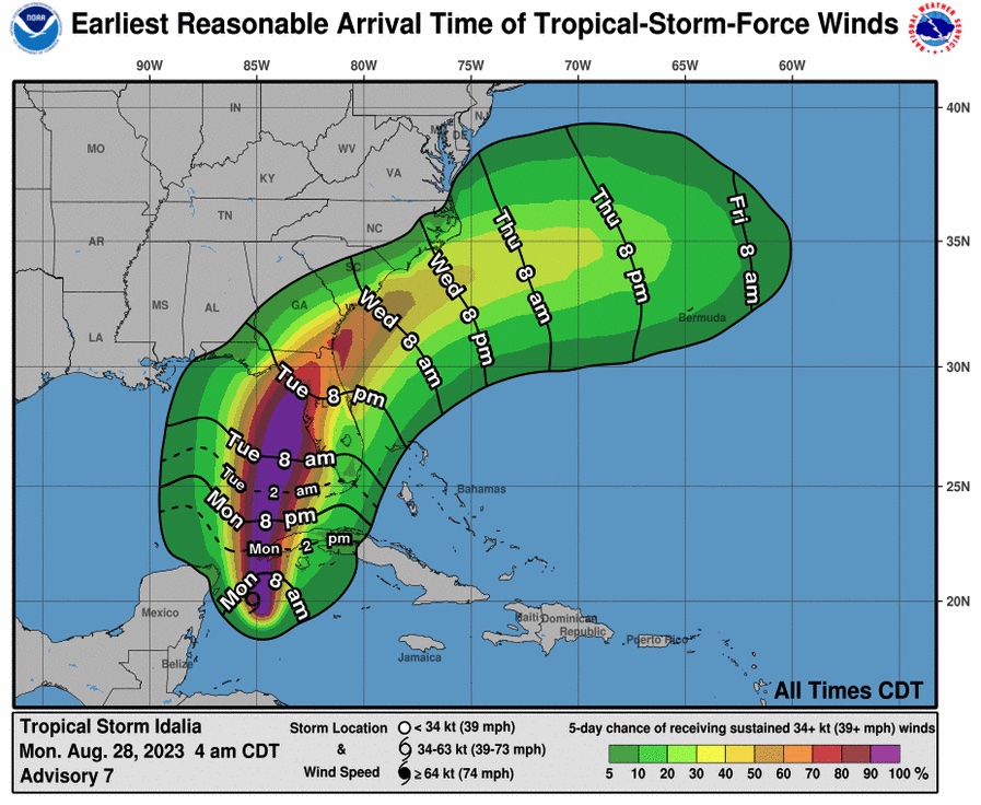
Code:ZCZC MIATCPAT5 ALL TTAA00 KNHC DDHHMM BULLETIN Tropical Storm Idalia Advisory Number 7 NWS National Hurricane Center Miami FL AL102023 400 AM CDT Mon Aug 28 2023 ...IDALIA INTENSIFYING AS IT APPROACHES CUBA... ...LIFE-THREATENING STORM SURGE AND DANGEROUS WINDS BECOMING INCREASINGLY LIKELY FOR PORTIONS OF FLORIDA... SUMMARY OF 400 AM CDT...0900 UTC...INFORMATION ---------------------------------------------- LOCATION...20.1N 85.2W ABOUT 125 MI...200 KM S OF THE WESTERN TIP OF CUBA MAXIMUM SUSTAINED WINDS...65 MPH...100 KM/H PRESENT MOVEMENT...N OR 360 DEGREES AT 7 MPH...11 KM/H MINIMUM CENTRAL PRESSURE...989 MB...29.21 INCHES WATCHES AND WARNINGS -------------------- CHANGES WITH THIS ADVISORY: None. SUMMARY OF WATCHES AND WARNINGS IN EFFECT: A Hurricane Warning is in effect for... * Pinar del Rio Cuba A Tropical Storm Warning is in effect for... * Yucatan Peninsula from Tulum to Rio Lagartos, including Cozumel * Isle of Youth Cuba * Dry Tortugas Florida A Storm Surge Watch is in effect for... * Chokoloskee to Indian Pass Florida, including Tampa Bay A Hurricane Watch is in effect for... * Englewood to Indian Pass Florida, including Tampa Bay A Tropical Storm Watch is in effect for... * South of Englewood to Chokoloskee Florida * Lower Florida Keys west of the west end of the Seven Mile Bridge A Hurricane Warning means that hurricane conditions are expected somewhere within the warning area, in this case within the next 12-24 hours. Preparations to protect life and property should be rushed to completion. A Storm Surge Watch means there is a possibility of life- threatening inundation, from rising water moving inland from the coastline, in the indicated locations during the next 48 hours. For a depiction of areas at risk, please see the National Weather Service Storm Surge Watch/Warning Graphic, available at hurricanes.gov. A Hurricane Watch means that hurricane conditions are possible within the watch area. A Tropical Storm Warning means that tropical storm conditions are expected somewhere within the warning area. A Tropical Storm Watch means that tropical storm conditions are possible within the watch area. Interests along the southeastern U.S. coast should monitor the progress of this system. Additional watches and warnings will likely be required later this morning. For storm information specific to your area in the United States, including possible inland watches and warnings, please monitor products issued by your local National Weather Service forecast office. For storm information specific to your area outside of the United States, please monitor products issued by your national meteorological service. DISCUSSION AND OUTLOOK ---------------------- At 400 AM CDT (0900 UTC), the center of Tropical Storm Idalia was located near latitude 20.1 North, longitude 85.2 West. Idalia is moving toward the north near 7 mph (11 km/h), with a continued northward motion bringing the center of Idalia near or over western Cuba tonight and over the extreme southeastern Gulf of Mexico by early Tuesday. On the forecast track, Idalia is forecast to increase in forward speed and turn north-northeastward over the eastern Gulf of Mexico on Tuesday and reach the Gulf coast of Florida on Wednesday. Maximum sustained winds have increased to near 65 mph (100 km/h) with higher gusts. Idalia is forecast to become a hurricane later today and a dangerous major hurricane over northeastern Gulf of Mexico by early Wednesday. Tropical-storm-force winds extend outward up to 70 miles (110 km) from the center. The estimated minimum central pressure is 989 mb (29.21 inches). HAZARDS AFFECTING LAND ---------------------- Key messages for Idalia can be found in the Tropical Cyclone Discussion under AWIPS header MIATCDAT5 and WMO header WTNT45 KNHC, and on the web at hurricanes.gov/text/MIATCDAT5.shtml STORM SURGE: The combination of a dangerous storm surge and the tide will cause normally dry areas near the coast to be flooded by rising waters moving inland from the shoreline. The water could reach the following heights above ground somewhere in the indicated areas if the peak surge occurs at the time of high tide... Aucilla River, FL to Chassahowitzka, FL...7-11 ft Chassahowitzka, FL to Anclote River, FL...6-9 ft Ochlockonee River, FL to Aucilla River, FL...4-7 ft Anclote River, FL to Middle of Longboat Key, FL...4-7 ft Tampa Bay...4-7 ft Middle of Longboat Key, FL to Englewood, FL...3-5 ft Englewood, FL to Chokoloskee, FL...2-4 ft Charlotte Harbor...2-4 ft Indian Pass, FL to Ochlockonee River, FL...2-4 ft Chokoloskee, FL to East Cape Sable, FL...1-3 ft Florida Keys...1-2 ft The deepest water will occur along the immediate coast in areas of onshore winds, where the surge will be accompanied by large and dangerous waves. Surge-related flooding depends on the relative timing of the surge and the tidal cycle, and can vary greatly over short distances. For information specific to your area, please see products issued by your local National Weather Service forecast office. Storm surge will raise water levels by as much as 4 to 6 feet above normal tide levels along the southern coast of Pinar del Rio, Cuba. Near the coast, the surge will be accompanied by large waves. WIND: Hurricane conditions are expected within the hurricane warning area in western Cuba later today. Winds are expected to first reach tropical storm strength by this morning, making outside preparations difficult or dangerous. Preparations to protect life and property should be rushed to completion. Tropical storm conditions are expected over portions of the tropical storm warning area over the Yucatan Peninsula and the Isle of Youth in Cuba through today Hurricane conditions are possible within the hurricane watch area by late Tuesday or Wednesday, with tropical storm conditions possible by Tuesday. Tropical storm conditions are possible in the Dry Tortugas beginning late today and within the tropical storm watch area along the Florida Gulf coast on Tuesday. RAINFALL: Idalia is expected to produce the following rainfall amounts: Portions of the eastern Yucatan: Additional 1 to 2 inches. Western Cuba: 4 to 7 inches, with isolated higher totals of 10 inches. Portions of the west coast of Florida, the Florida Panhandle, southeast Georgia and the eastern Carolinas: 4 to 8 inches from Tuesday into Thursday. Isolated higher totals of 12 inches possible, primarily near landfall in northern Florida. This rainfall may lead to flash and urban flooding, and landslides across western Cuba. Areas of flash and urban flooding, some of which may be locally significant, are expected across portions of the west coast of Florida, the Florida Panhandle, and southern Georgia Tuesday into Wednesday, spreading into portions of the eastern Carolinas Wednesday into Thursday. SURF: Swells generated by Idalia are affecting portions of the southern coast of Cuba and eastern Yucatan. These swells are likely to cause life-threatening surf and rip current conditions. Please consult products from your local weather office. NEXT ADVISORY ------------- Next intermediate advisory at 700 AM CDT. Next complete advisory at 1000 AM CDT. $$ Forecaster Blake NNNN
View attachment 739522
Guide to Walt Disney World's Policy on Hurricane Cancellations and Refunds
Guide to Walt Disney World's Policy on Hurricane Cancellations and Refunds
Guide to Walt Disney World's Policy on Hurricane Cancellations and Refunds
 www.wdwmagic.com
Doberge
True Bayou Magic
I don't like that projected intensity has increased seemingly daily from tropical storm to cat 1 to cat 2 to cat 3. Idalia is currently projected fly through the Gulf but anything currently unprojected could slow it down and further intensity. In 2021 with Hurricane Ida 48 hours out projections were 120 mph winds (mid cat 3) and Louisiana ended up hit with 150 (strong cat 4, 7mph from cat 5). That's just a reminder that projections are still works in progress and that hopefully folks in harms way prep for worse and end with a storm that fizzles out before landfall.
Also, Idalia is a weirdly similar name to Ida. Ida was the 6th costliest in US history and thus retired as a name. I would have guessed they'd come up a different name for Idalia.
Also, Idalia is a weirdly similar name to Ida. Ida was the 6th costliest in US history and thus retired as a name. I would have guessed they'd come up a different name for Idalia.
Eric Graham
Well-Known Member
I would avoid this gas if you live in Florida because it may contain diesel. . .

Florida Gulf Coast drivers warned of contaminated gas as Tropical Storm Idalia bears down
Gas contaminated with diesel fuel could have been purchased along the Gulf Coast on Sunday as Florida residents prepared for Tropical Storm Idalia.
www.usatoday.com
Register on WDWMAGIC. This sidebar will go away, and you'll see fewer ads.