-
Welcome to the WDWMAGIC.COM Forums!
Please take a look around, and feel free to sign up and join the community.
You are using an out of date browser. It may not display this or other websites correctly.
You should upgrade or use an alternative browser.
You should upgrade or use an alternative browser.
Hurricane Helene (2024)
- Thread starter Gringrinngghost
- Start date
Lots of uncertainty in the track. A couple of mile deviation could make a big difference.
Given the favorable conditions on the gulf, this could get big quickly, just like Ian.
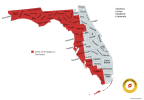
State of Emergency has been declared for Alachua, Bay, Bradford, Calhoun, Charlotte, Citrus, Collier, Columbia, Dixie, Escambia, Franklin, Gadsden, Gilchrist, Gulf, Hamilton, Hernando, Hillsborough, Holmes, Jackson, Jefferson, Lafayette, Lee, Leon, Levy, Liberty, Madison, Manatee, Marion, Monroe, Okaloosa, Pasco, Pinellas, Santa Rosa, Sarasota, Sumter, Suwannee, Taylor, Union, Wakulla, Walton, and Washington counties.

Last edited:
danlb_2000
Premium Member
Lots of uncertainty in the track. A couple of mile deviation could make a big difference.
Given the favorable conditions on the gulf, this could get big quickly, just like Ian.
Yeah, I was just watching a video about this one, they said there is basically nothing to prevent this from really intensifying.
Yep. Bombogenesis will be fun.Yeah, I was just watching a video about this one, they said there is basically nothing to prevent this from really intensifying.
We are going to Mickey's Thursday night. Since it is supposed to hit the coast Thursday morning I doubt Thursday night will be good, I would assume it rains and is really windy all day/nightI’m supposed to go to Halloween Horror Nights on Thursday. I hope all will be good then in this area.
Ayla
Well-Known Member
I believe the purpose of that is so state and local resources can now be utilized to prepare for the storm...but I don't live in a hurricane zone and never have, so don't quote me on that! I could be 100% wrong.State of Emergency has been declared for Alachua, Bay, Bradford, Calhoun, Charlotte, Citrus, Collier, Columbia, Dixie, Escambia, Franklin, Gadsden, Gilchrist, Gulf, Hamilton, Hernando, Hillsborough, Holmes, Jackson, Jefferson, Lafayette, Lee, Leon, Levy, Liberty, Madison, Manatee, Marion, Monroe, Okaloosa, Pasco, Pinellas, Santa Rosa, Sarasota, Sumter, Suwannee, Taylor, Union, Wakulla, Walton, and Washington counties.
View attachment 817435
An emergency declaration helps state agencies prepare for storm response.I believe the purpose of that is so state and local resources can now be utilized to prepare for the storm...but I don't live in a hurricane zone and never have, so don't quote me on that! I could be 100% wrong.
Code:
000
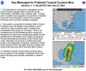
WTNT34 KNHC 232052
TCPAT4

BULLETIN
Potential Tropical Cyclone Nine Advisory Number   2
NWS National Hurricane Center Miami FL       AL092024
500 PM EDT Mon Sep 23 2024

...DISTURBANCE FORECAST TO STRENGTHEN SIGNIFICANTLY DURING THE NEXT
FEW DAYS...
...TROPICAL STORM WATCHES ISSUED FOR THE LOWER FLORIDA KEYS AND DRY
TORTUGAS...


SUMMARY OF 500 PM EDT...2100 UTC...INFORMATION
----------------------------------------------
LOCATION...18.1N 82.2W
ABOUT 105 MI...170 KM SW OF GRAND CAYMAN
ABOUT 315 MI...510 KM SE OF THE WESTERN TIP OF CUBA
MAXIMUM SUSTAINED WINDS...35 MPH...55 KM/H
PRESENT MOVEMENT...NNW OR 345 DEGREES AT 7 MPH...11 KM/H
MINIMUM CENTRAL PRESSURE...1003 MB...29.62 INCHES


WATCHES AND WARNINGS
--------------------
CHANGES WITH THIS ADVISORY:

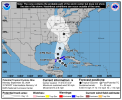
A Tropical Storm Watch has been issued for the Dry Tortugas and the
Lower Florida Keys south of the Seven Mile Bridge.

SUMMARY OF WATCHES AND WARNINGS IN EFFECT:

A Hurricane Watch is in effect for...
* Cabo Catoche to Tulum, Mexico
* Cuban province of Pinar del Rio

A Tropical Storm Warning is in effect for...
* Rio Lagartos to Tulum, Mexico
* Cuban provinces of Artemisa, and Pinar del Rio, and the Isle of
Youth

A Tropical Storm Watch is in effect for...
* Dry Tortugas
* Lower Keys south of the Seven Mile Bridge

A Tropical Storm Warning means that tropical storm conditions are
expected somewhere within the warning area, in this case within
the next 24 to 36 hours.

A Hurricane Watch means that hurricane conditions are possible
within the watch area. A watch is typically issued 48 hours
before the anticipated first occurrence of tropical-storm-force
winds, conditions that make outside preparations difficult or
dangerous.

A Tropical Storm Watch means that tropical storm conditions are
possible within the watch area, generally within 48 hours.

Interests along the northeastern Gulf Coast, including the Florida
Panhandle and portions of the Florida west coast, should monitor
the progress of this system. Additional watches or warnings will
likely be required tonight and Tuesday.

For storm information specific to your area in the United States,
including possible inland watches and warnings, please monitor
products issued by your local National Weather Service forecast
office. For storm information specific to your area outside of the
United States, please monitor products issued by your national
meteorological service.


DISCUSSION AND OUTLOOK
----------------------
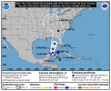
At 500 PM EDT (2100 UTC), the disturbance was centered near latitude
18.1 North, longitude 82.2 West. The system is moving toward the
north-northwest near 7 mph (11 km/h). A northwestward motion is
expected on Tuesday and Tuesday night, followed by a faster
northward to north-northeastward motion on Wednesday and Thursday.
On the forecast track, the center of the system is forecast to move
across the northwestern Caribbean Sea through Tuesday night, and
then over the eastern Gulf of Mexico on Wednesday and Thursday.

Maximum sustained winds have increased to near 35 mph (55 km/h) with
higher gusts. Strengthening is expected during the next few days,
and the system is forecast to become a hurricane on Wednesday and
continue strengthening on Thursday as it moves across the eastern
Gulf of Mexico.
* Formation chance through 48 hours...high...90 percent.
* Formation chance through 7 days...high...90 percent.

The estimated minimum central pressure is 1003 mb (29.62 inches).


HAZARDS AFFECTING LAND
----------------------
Key Messages for Potential Tropical Cyclone Nine can be found in
the Tropical Cyclone Discussion under AWIPS header MIATCDAT4 and
WMO header WTNT44 KNHC and on the web at
hurricanes.gov/text/MIATCDAT4.shtml

RAINFALL: Potential Tropical Cyclone Nine is expected to produce
total rain accumulations of 4 to 8 inches over western Cuba and the
Cayman Islands with isolated totals around 12 inches. Over the
eastern Yucatan Peninsula, 2 to 4 inches of rain is expected with
isolated totals over 6 inches. This rainfall brings a risk of
considerable flooding.

Over the Southeastern U.S., Potential Tropical Cyclone Nine is
expected to produce total rain accumulations of 3 to 6 inches with
isolated totals around 10 inches, bringing a risk of flooding, some
of which could be considerable.

For a complete depiction of forecast rainfall associated with
Potential Tropical Cyclone Nine, please see the National Weather
Service Storm Total Rainfall Graphic, available at
hurricanes.gov/graphics_at4.shtml?rainqpf and the Flash Flood Risk
graphic at hurricanes.gov/graphics_at4.shtml?ero

STORM SURGE: The combination of a dangerous storm surge and the
tide will cause normally dry areas near the coast to be flooded by
rising waters moving inland from the shoreline.  The water could
reach the following heights above ground somewhere in the indicated
areas if the peak surge occurs at the time of high tide...

Dry Tortugas...1-3 ft
Florida Keys...1-3 ft

Storm surge could raise water levels by as much as 2 to 4 feet above
normal tide levels in areas of onshore winds along the southern
coast of Pinar del Rio, Cuba, including the Isle of Youth.

Storm surge could raise water levels by as much as 2 to 4 feet above
ground level in areas of onshore winds within the warning area along
the east coast of the Yucatan Peninsula.

WIND: Hurricane conditions are possible within the watch areas in
Cuba and Mexico by early Wednesday. Tropical storm conditions are
expected in the warning areas in Cuba and Mexico beginning on
Tuesday. Tropical storm conditions are possible in the watch area
beginning on Wednesday.

SURF: Swells generated by the system will affect the southern coast
of Cuba and the Yucatan Peninsula of Mexico during the next couple
of days. Swells will spread northward toward the west coast of
Florida and the northeastern Gulf Coast on Wednesday and Thursday.
These swells are likely to cause life-threatening surf and rip
current conditions.  Please consult products from your local weather
office.


NEXT ADVISORY
-------------
Next intermediate advisory at 800 PM EDT.
Next complete advisory at 1100 PM EDT.

$$
Forecaster Reinhart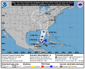
networkpro
Well-Known Member
- In the Parks
- Yes
I'm glad we didnt pick up MNSSHP for Thursday. Looks like its just going to be just wet here at WDW. Resort food for Wednesday evening and Thursday lunch now 
I'm glad we didnt pick up MNSSHP for Thursday. Looks like its just going to be just wet here at WDW. Resort food for Wednesday evening and Thursday lunch now
The food options weren't bad in September 2022 for Ian, but eating them for a day-plus would get old fast (Of course, staying in a 1-bedroom during that hurricane had its advantages). I'm curious to know if they'll offer the same things this week, if necessary.
John park hopper
Well-Known Member
Wow this looks like it could be a repeat of hurricane Michael in 2018 (cat 5) which hit that part of FL------hopefully this doesn't reach that status.
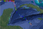
We are slowly starting to get new model runs in. The ICON model has shifted about 75 miles eastward, and has 72 hours out the center of the storm roughly 45 miles from Tampa to the West South West. The NAM model is more westward, but is total garbage, and would have it at 989mb, or a Cat 1 with very minimal intensity gain.Wow this looks like it could be a repeat of hurricane Michael in 2018 (cat 5) which hit that part of FL------hopefully this doesn't reach that status.
Suffice it to say, too early to call.
John park hopper
Well-Known Member
National hurricane center has it sa a major storm making land fall cat 1 --hope I am wrong but I don't see itWe are slowly starting to get new model runs in. The ICON model has shifted about 75 miles eastward, and has 72 hours out the center of the storm roughly 45 miles from Tampa to the West South West. The NAM model is more westward, but is total garbage, and would have it at 989mb, or a Cat 1 with very minimal intensity gain.
Suffice it to say, too early to call.
Consensus is a Cat 3+.National hurricane center has it sa a major storm making land fall cat 1 --hope I am wrong but I don't see it
That all being said, the data that I am looking at had no bearing to the 5PM EDT advisory. It will be taken in consideration for 11PM or 8PM if they do a track update then.
John park hopper
Well-Known Member
I've got family in Gulf Breeze FL --hoping it stays on present track and does not shift west.
Register on WDWMAGIC. This sidebar will go away, and you'll see fewer ads.

