-
Welcome to the WDWMAGIC.COM Forums!
Please take a look around, and feel free to sign up and join the community.
You are using an out of date browser. It may not display this or other websites correctly.
You should upgrade or use an alternative browser.
You should upgrade or use an alternative browser.
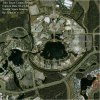
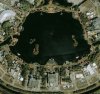
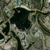
New EPCOT Satellite photo from 03-21-00.
- Thread starter DonickCo
- Start date
isnet396
New Member
Disney4648
New Member
We can see these photos anytime on places like maps.com and stuff.

CAPTAIN HOOK
Well-Known Member
Ignore the scatheing remarks - I think the images are cool - keep posting!!!!!!!!
Wilt Dasney
Well-Known Member
Diplomacy @ Work
Hey, fellas, before we get too many hurt feelings here: I don't think the first few posters were trying to be pricks, they just weren't sure why you were posting "just another" satellite pic, until you pointed out the work you had done on it. I was kind of wondering myself at first, then I read what you wrote and went back and noticed all the detail in the picture. Good work, DonickCo; it's really an incredible pic.
Peace.
Originally posted by DonickCo
I have it at 1 meter resolution at 2000x2000 pixels in a 14 MB .tif file but I had to scale it down to 740x740 for the sight. It is 72 layers stitched together. One layer being a satellite photo at the highest resolution possible.
-DonickCo
VERY nice work!!
")
If you would be willing, it would be great to be able to put the full resolution version up? If you would like to do that, I can send you some FTP details where you can upload it to, and I will make it available here on the forum. If you are interested email me at steve@wdwmagic.com
Thanks!
Maria
New Member
Re: Diplomacy @ Work
I agree with Wilt.... same thing happened to me after reading it was a pic from March 2000, until he wrote all the work he had put into the pic. :animwink: Let´s not jump into conclusions! :kiss:
DonickCo, could you please post one like the second one, but for World Showcase? Thank you!
Originally posted by Wilt Dasney
Hey, fellas, before we get too many hurt feelings here: I don't think the first few posters were trying to be pricks, they just weren't sure why you were posting "just another" satellite pic, until you pointed out the work you had done on it. I was kind of wondering myself at first, then I read what you wrote and went back and noticed all the detail in the picture. Good work, DonickCo; it's really an incredible pic.
Peace.
I agree with Wilt.... same thing happened to me after reading it was a pic from March 2000, until he wrote all the work he had put into the pic. :animwink: Let´s not jump into conclusions! :kiss:
DonickCo, could you please post one like the second one, but for World Showcase? Thank you!
Supasnapper2
New Member
Great work - keep 'em coming:sohappy: :sohappy:
TinkerBell9988
Well-Known Member
Originally posted by DonickCo
Thank you. It stinks when you work really hard on something, then when you go to share, people complain. I’m glade someone appreciates it.
Thanks
-DonickCo
I appreciate those sattelite pix very much! I think they are very nice to have! People, please stop complaining... this IS the Digital Media and PHOTOS category... its not like its in the wrong one...
By the way, I especially like this pic because Horizons is still there...


Register on WDWMAGIC. This sidebar will go away, and you'll see fewer ads.