Hey y'all, I was just having a browse on Google Earth before and decided to scoot over to have a look at the DLRP view as I had never done this before. If any of you have ever viewed the site from above before you probably noticed a large circular road around the perimeter of the resort. My question is everything within this perimeter owned by EuroDisney? If so, there is alot of room to expand should they ever choose to go further.
-
The new WDWMAGIC iOS app is here!
Stay up to date with the latest Disney news, photos, and discussions right from your iPhone. The app is free to download and gives you quick access to news articles, forums, photo galleries, park hours, weather and Lightning Lane pricing. Learn More -
Welcome to the WDWMAGIC.COM Forums!
Please take a look around, and feel free to sign up and join the community.
You are using an out of date browser. It may not display this or other websites correctly.
You should upgrade or use an alternative browser.
You should upgrade or use an alternative browser.
Future Expansion
- Thread starter DieHardDisney
- Start date
Yes and yes! Everything inside the circular road is DLRP. At the bottom right is a long major road that connects to a highway. This is DLRPs World Drive. They own some of the land adjacent to this too - you can see DLP Golf next to it for example. I`ll try to rustle up an overlay showing expansion plans - now and in the past.
That would be great marni, wouldn't mind a peek at those proposed expansion plans, sounds interesting!!
RonAnnArbor
Well-Known Member
Although there isn't currently anything planned for expansion - they are just trying to keep their current properties bringing in money to erase their restructuring costs from last year (which is planned for at least the next 7 years).
Here are some plans, as requested. Bear in mind not all these have or will come to frutition, but thats what makes them so interesting!
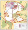
The first shows total DLRP property pretty much as it is today. Although old, it does show the land earmarked eventually for the studios.
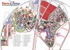
The second is an expansion plot plan of the main resort area (plots outlined in red)-
The bottom is obviously the Studios area. Center bottom you have one of the original hotel / convention areas. Above and to the right are 2 plots - the smaller is Disney Village expansion, the larger the original site of the New Orleans Resort (never built)
The 4 large plots at the right are resort areas, and possibly the top one the Lava Lagoon water park. The single lane road that runs along these to the left of them was designed and built to be easily converted into a duel carriageway roadway should this expanion happen.
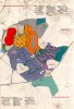
Moving into Disneyland Parc (the Magic Kingdom), starting at the bottom, below the number 10, was the location of Geyser Mountain. Anything here now is pretty much ruled out since the studios Catastrophe Canyon is in the vicinity beyond the berm. Moving clockwise, the next area is mainly backstage, but does actually include on stage. This is the location of the Splash Mountain hybrid attraction; including remodeling of the train station area. Next up is the original plot of the duel attraction Indiana Jones Temple rollercoaster and Jungle Exploration 1st gen EMV. It would have straddled the berm and railroad. The Indy coaster was built in its smaller form where it is today, but half this plot is still empty.
Clockwise again the plot at the top is where Storybookland was built. To the right are 2 more beyond the berm areas - the first is the location of The Little Mermaid Dark Ride, the second mostly empty and used for catering.
Inside of the berm are 4 areas. The leftmost one is currently landscaped; this was the location of the Beauty and The Beast interactive stageshow. To it`s right are 2 joined areas; the larger one was Discovery Mountain. Both were combined in a smaller form for Space Mountain and the Nautillus walk through. The last area (the smallest) was to be the parks premier restaurant. Themed to Discoveryland, but using the Plaza pavilions (which it backs onto) kitchens it was to be called the Vulcania.
Finally is the original EDL site plan. It shows the original land zoning, but more interestingly, to the right of the red Disney-MGM Europe area, it shows the original second parking lot envisaged for the studios, complete with separate entrance and exit roads, feeder roads, toll booths and guest tram service.
The first shows total DLRP property pretty much as it is today. Although old, it does show the land earmarked eventually for the studios.
The second is an expansion plot plan of the main resort area (plots outlined in red)-
The bottom is obviously the Studios area. Center bottom you have one of the original hotel / convention areas. Above and to the right are 2 plots - the smaller is Disney Village expansion, the larger the original site of the New Orleans Resort (never built)
The 4 large plots at the right are resort areas, and possibly the top one the Lava Lagoon water park. The single lane road that runs along these to the left of them was designed and built to be easily converted into a duel carriageway roadway should this expanion happen.
Moving into Disneyland Parc (the Magic Kingdom), starting at the bottom, below the number 10, was the location of Geyser Mountain. Anything here now is pretty much ruled out since the studios Catastrophe Canyon is in the vicinity beyond the berm. Moving clockwise, the next area is mainly backstage, but does actually include on stage. This is the location of the Splash Mountain hybrid attraction; including remodeling of the train station area. Next up is the original plot of the duel attraction Indiana Jones Temple rollercoaster and Jungle Exploration 1st gen EMV. It would have straddled the berm and railroad. The Indy coaster was built in its smaller form where it is today, but half this plot is still empty.
Clockwise again the plot at the top is where Storybookland was built. To the right are 2 more beyond the berm areas - the first is the location of The Little Mermaid Dark Ride, the second mostly empty and used for catering.
Inside of the berm are 4 areas. The leftmost one is currently landscaped; this was the location of the Beauty and The Beast interactive stageshow. To it`s right are 2 joined areas; the larger one was Discovery Mountain. Both were combined in a smaller form for Space Mountain and the Nautillus walk through. The last area (the smallest) was to be the parks premier restaurant. Themed to Discoveryland, but using the Plaza pavilions (which it backs onto) kitchens it was to be called the Vulcania.
Finally is the original EDL site plan. It shows the original land zoning, but more interestingly, to the right of the red Disney-MGM Europe area, it shows the original second parking lot envisaged for the studios, complete with separate entrance and exit roads, feeder roads, toll booths and guest tram service.
Attachments
Andy - there is reserved space for a 3rd gate. South and East of Blvd Du Parc / Due south of the purple resort area on the first image above is the favourite location.
Google Earth has recently updated it`s DLP imagery; have a look at 48 51 54 93 North 2 47 49 93 east.
Google Earth has recently updated it`s DLP imagery; have a look at 48 51 54 93 North 2 47 49 93 east.
jrriddle
Well-Known Member
marni1971 said:Here are some plans, as requested. Bear in mind not all these have or will come to frutition, but thats what makes them so interesting!
The first shows total DLRP property pretty much as it is today. Although old, it does show the land earmarked eventually for the studios.
The second is an expansion plot plan of the main resort area (plots outlined in red)-
The bottom is obviously the Studios area. Center bottom you have one of the original hotel / convention areas. Above and to the right are 2 plots - the smaller is Disney Village expansion, the larger the original site of the New Orleans Resort (never built)
The 4 large plots at the right are resort areas, and possibly the top one the Lava Lagoon water park. The single lane road that runs along these to the left of them was designed and built to be easily converted into a duel carriageway roadway should this expanion happen.
Moving into Disneyland Parc (the Magic Kingdom), starting at the bottom, below the number 10, was the location of Geyser Mountain. Anything here now is pretty much ruled out since the studios Catastrophe Canyon is in the vicinity beyond the berm. Moving clockwise, the next area is mainly backstage, but does actually include on stage. This is the location of the Splash Mountain hybrid attraction; including remodeling of the train station area. Next up is the original plot of the duel attraction Indiana Jones Temple rollercoaster and Jungle Exploration 1st gen EMV. It would have straddled the berm and railroad. The Indy coaster was built in its smaller form where it is today, but half this plot is still empty.
Clockwise again the plot at the top is where Storybookland was built. To the right are 2 more beyond the berm areas - the first is the location of The Little Mermaid Dark Ride, the second mostly empty and used for catering.
Inside of the berm are 4 areas. The leftmost one is currently landscaped; this was the location of the Beauty and The Beast interactive stageshow. To it`s right are 2 joined areas; the larger one was Discovery Mountain. Both were combined in a smaller form for Space Mountain and the Nautillus walk through. The last area (the smallest) was to be the parks premier restaurant. Themed to Discoveryland, but using the Plaza pavilions (which it backs onto) kitchens it was to be called the Vulcania.
Finally is the original EDL site plan. It shows the original land zoning, but more interestingly, to the right of the red Disney-MGM Europe area, it shows the original second parking lot envisaged for the studios, complete with separate entrance and exit roads, feeder roads, toll booths and guest tram service.
I thought that we agreed ages ago that:
Little Mermaid was to go in that space behind Videopolis.
Beauty and The Beast was to go on that grassy hill beside La Brave Petit Tailleur and Auberge de Cendrillon
And that Geyser Mountain could still fit (according to your maps and calculations).:wave:
Register on WDWMAGIC. This sidebar will go away, and you'll see fewer ads.