I came across this photo well sorting through some files on my computer.
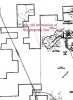
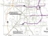
From what I have seen this image seams to be from around 1997 probably earlier. I also feel that the under lying map came from within Disney, the property seams to be extended in the NW corner of the map, connecting Disney property around a proposed western road. I have never seen this extended property line before. Someone may have used this map to sketch out a transpiration map.
Full Photo @ http://photoalbums.wdwmagic.com/showgallery.php?ppuser=1327&cat=500&thumb=1
-DonickCo

")
")