A picture is worth a thousand words.

Coronado

Member
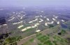
What a mistery! I looked at this site from several sources including aerial photo, satelite immaging, and tera service....I have a guess....they are green house plant nurseries... they sure use a lot of plants at WDW....AK was to have vegetation replaced regularly because the animals eat or trample it..... The black edge around the edges could be screening.... Hey ever notice that you do not see any animal ________ along the trail??? They may be growing these plants hydroponically....The individual cells that are bounded by dirt roads seem to be joined along the side and have a single entry along each side that leads to the perimeter roads.....guess number two ... they are empty aquaculture farm plots.....dats my guess....what about yours?
 

Attachments

  • zazu02.gif
    zazu02.gif
    5.4 KB · Views: 270

Maria

New Member
You may be right Coronado!

I searched on my Cast Atlas, but it is not to scale. I thought it was the All Stars, but DBF says it is south of that which leaves me even more clueless.

However, north of them in my map, there is a huge area that says "Tree Farm and Nursery", and it is close to the "Compost facility". It does have the same shape that those buildings form.

So I think you are right!
 

Maria

New Member
Re: The Mystery Solved

Originally posted by DBF John
This is a network of Rapid Infiltration Basins, they are used for ground water recharge, with a permited use of 15 million gallons per day.

Ok Mrs.Fletcher, you are not just going to say that without saying HOW you knew it! We demand an explanation! :lol: ;)
 

s25843

Well-Known Member
Originally posted by DBF John
And by the way Maria, I thought I was crazy seeing the Hidden Mickey, but I guess it is there, the more I look at it the more I see it.
Isnt That At The Speedway?
 

Mr. Toad

Active Member
OK so the area that looks like a "residential community" is actually irrigation basins.

I realized after I posted the the landfill is actually the area circled in red on the original picture (which is about 1.5 miles W of MK). Anyone know what a Class III landfill holds?
 

DonickCo

Active Member
Original Poster
What is a Class III Landfill?

A Class III municipal solid waste landfill (MSWLF) is one that is considered to be small, rural, and remote. It accepts less than five tons of municipal solid waste per day (on an annual average). It is usually not connected by road to a Class I landfill, which is a large landfill facility that accepts more than 20 tons of waste daily and must meet special requirements for liners, leachate collection, methane gas monitoring, and water quality sampling. To qualify as a Class III landfill, a community that is connected to a road system that is maintained year-round, must be located a distance of more than 50 miles from a Class I landfill. (18 AAC 60.300(c)(3))

http://www.state.ak.us/dec/deh/solidwaste/muni2.htm
 

mickeykid79

Member
While doing some exploring the landfill the document states is the dumpsite just north west near frontierland. That mysterious site is a Time share development.
 

Register on WDWMAGIC. This sidebar will go away, and you'll see fewer ads.

Back
Top Bottom