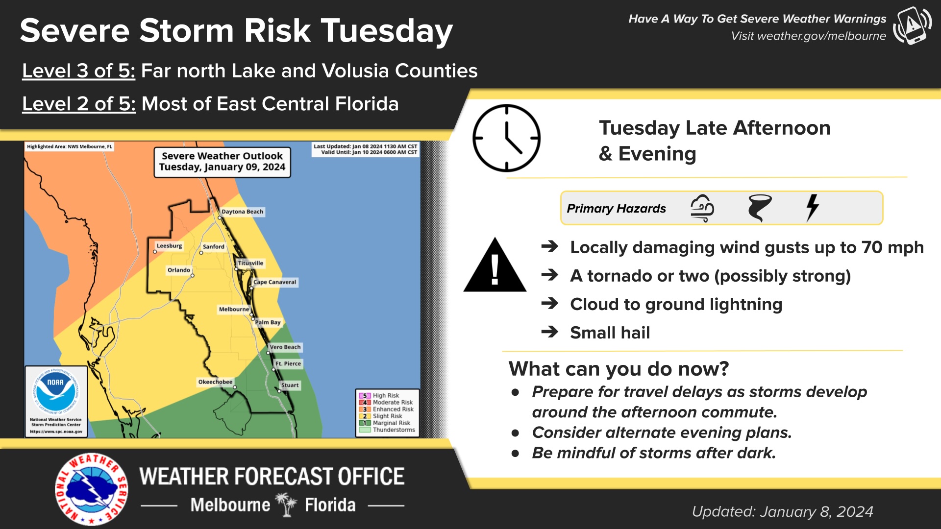
Potential severe weather threatens Walt Disney World as cold front approaches
Potential severe weather threatens Walt Disney World as cold front approaches

Not much snow tomorrow here in New England but when it warms up they are saying 2” or more of rain. That will make a mess on top of the 10” of snow we got over the weekend.Saucy, try entire Eastern US tomorrow. I’m getting 8-12 inches up in WI, and the NE will be similarly clobbered. Good luck to anyone traveling tomorrow.
I am flying into Orlando tomorrow evening….
Feeling a bit tense, hoping my flight makes it there!
-
Thank you!I hope you have a safe trip. Its going to be a bit rough in Middle Georgia with 50-60 MPH winds and 4-8 inches of rain.
You must not be very far from me. I live at the south end of the lake.Saucy, try entire Eastern US tomorrow. I’m getting 8-12 inches up in WI, and the NE will be similarly clobbered. Good luck to anyone traveling tomorrow.
If you’re talking about Winnebago, no I’m in the Appleton area.You must not be very far from me. I live at the south end of the lake.
In the scheme of things, less than 50 miles is not very far.If you’re talking about Winnebago, no I’m in the Appleton area.

URGENT - IMMEDIATE BROADCAST REQUESTED
Tornado Watch Number 6
NWS Storm Prediction Center Norman OK
115 PM EST Tue Jan 9 2024
The NWS Storm Prediction Center has issued a
* Tornado Watch for portions of
Central Florida
Coastal Waters
* Effective this Tuesday afternoon and evening from 115 PM until
900 PM EST.
* Primary threats include...
A few tornadoes and a couple intense tornadoes possible
Scattered damaging wind gusts to 70 mph likely
SUMMARY...An intense line of thunderstorms currently in the eastern
Gulf of Mexico will track across the central Florida Peninsula this
afternoon. The strongest cells will pose a risk of locally damaging
wind gusts and a few tornadoes.
The tornado watch area is approximately along and 70 statute miles
east and west of a line from 40 miles northeast of Ocala FL to 40
miles west of Fort Myers FL. For a complete depiction of the watch
see the associated watch outline update (WOUS64 KWNS WOU6).
PRECAUTIONARY/PREPAREDNESS ACTIONS...
REMEMBER...A Tornado Watch means conditions are favorable for
tornadoes and severe thunderstorms in and close to the watch
area. Persons in these areas should be on the lookout for
threatening weather conditions and listen for later statements
and possible warnings.
&&
OTHER WATCH INFORMATION...CONTINUE...WW 4...WW 5...
AVIATION...Tornadoes and a few severe thunderstorms with hail
surface and aloft to 1 inch. Extreme turbulence and surface wind
gusts to 60 knots. A few cumulonimbi with maximum tops to 500. Mean
storm motion vector 25035.
...Hart
PROBABILITY TABLE:
PROB OF 2 OR MORE TORNADOES : 50%
PROB OF 1 OR MORE STRONG /EF2-EF5/ TORNADOES : 30%
PROB OF 10 OR MORE SEVERE WIND EVENTS : 70%
PROB OF 1 OR MORE WIND EVENTS >= 65 KNOTS : 10%
PROB OF 10 OR MORE SEVERE HAIL EVENTS : <05%
PROB OF 1 OR MORE HAIL EVENTS >= 2 INCHES : <05%
PROB OF 6 OR MORE COMBINED SEVERE HAIL/WIND EVENTS : 80%
&&
ATTRIBUTE TABLE:
MAX HAIL /INCHES/ : 1.0
MAX WIND GUSTS SURFACE /KNOTS/ : 60
MAX TOPS /X 100 FEET/ : 500
MEAN STORM MOTION VECTOR /DEGREES AND KNOTS/ : 25035
PARTICULARLY DANGEROUS SITUATION : NO
&&
FOR A COMPLETE GEOGRAPHICAL DEPICTION OF THE WATCH AND
WATCH EXPIRATION INFORMATION SEE WOUS64 FOR WOU6.
$$
State of emergency declared in 49 counties, including Orange and Osceola.
DeSantis declares state of emergency for 49 Florida counties as tornados, storms rage

DeSantis declares state of emergency for 49 Florida counties as tornados, storms rage
Gov,. Ron DeSantis declared a state of emergency as tornados and storms left destruction across the Panhandle.www.tallahassee.com
Here's a photo from someone on the scene:Hearing reports of strong winds at MK right now. It's so strong that children are being carried away from their parents!
Hearing reports of strong winds at MK right now. It's so strong that children are being carried away from their parents!
Register on WDWMAGIC. This sidebar will go away, and you'll see fewer ads.
