-
The new WDWMAGIC iOS app is here!
Stay up to date with the latest Disney news, photos, and discussions right from your iPhone. The app is free to download and gives you quick access to news articles, forums, photo galleries, park hours, weather and Lightning Lane pricing. Learn More -
Welcome to the WDWMAGIC.COM Forums!
Please take a look around, and feel free to sign up and join the community.
You are using an out of date browser. It may not display this or other websites correctly.
You should upgrade or use an alternative browser.
You should upgrade or use an alternative browser.
News Hurricane Isaias possible impacts to the theme parks
- Thread starter wdwmagic
- Start date
Rider
Well-Known Member
Weathernerds TC Guidance
US and EU computer models. Both in agreement that the closer to Florida it tracks, the weaker this storm will be. Could be trouble for the Carolinas too.
heapster411
Well-Known Member
Careful, Icarus!Really? Based on what? A little rain? Yeah, never rains there.Gotta love you doom and gloomers.
Archie123
Well-Known Member
Careful, Icarus!
I think Chef gets paid every time he uses the phrase “doom and gloom”.
Chef Mickey
Well-Known Member
I wish. There sure is enough of it around here.I think Chef gets paid every time he uses the phrase “doom and gloom”.
Archie123
Well-Known Member
I wish. There sure is enough of it around here.
A pandemic will do that.
Chef Mickey
Well-Known Member
The news helps pound the narrative. Doom and gloom is many times exaggerated and speculated.A pandemic will do that.
Apple and Amazon proved the consumer is OK and things aren’t as bad as the news portrays. Google and Facebook also reported great numbers, as did many other companies. Travel companies are being hit the most, but as things open up, the worst is behind us and it only has been 4-5 months.
Again, lot of positives and brighter days ahead.
Archie123
Well-Known Member
The news helps pound the narrative. Doom and gloom is many times exaggerated and speculated.
Apple and Amazon proved the consumer is OK and things aren’t as bad as the news portrays. Google and Facebook also reported great numbers, as did many other companies. Travel companies are being hit the most, but as things open up, the worst is behind us and it only has been 4-5 months.
Again, lot of positives and brighter days ahead.
Yep. We’ve heard this same thing from you many times. The worst is behind us. Sad those darn news people reporting all those pesky facts seem to get in the way with that rosy narrative.
Chef Mickey
Well-Known Member
Lolll...yeah, the news...all facts.Yep. We’ve heard this same thing from you many times. The worst is behind us. Sad those darn news people reporting all those pesky facts seem to get in the way with that rosy narrative.
Go look at the Apple and Amazon quarters for some facts.
Markets are looking forward, not backward. Worst is behind us and if it’s not, we’ll get through that too. We always do...that’s why you always have to be long. Bulls always win.
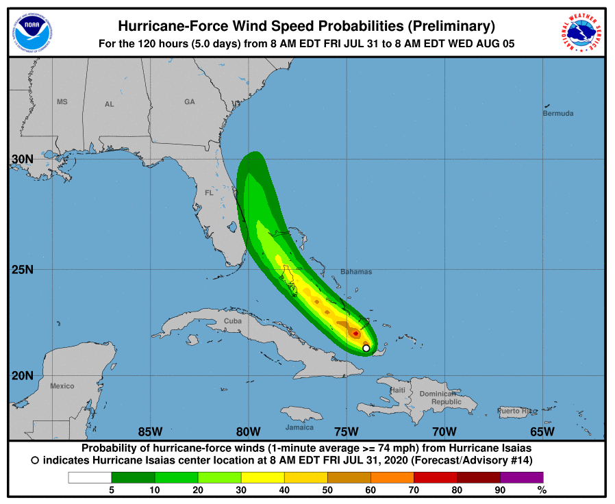
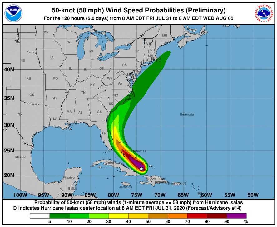
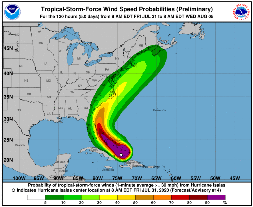
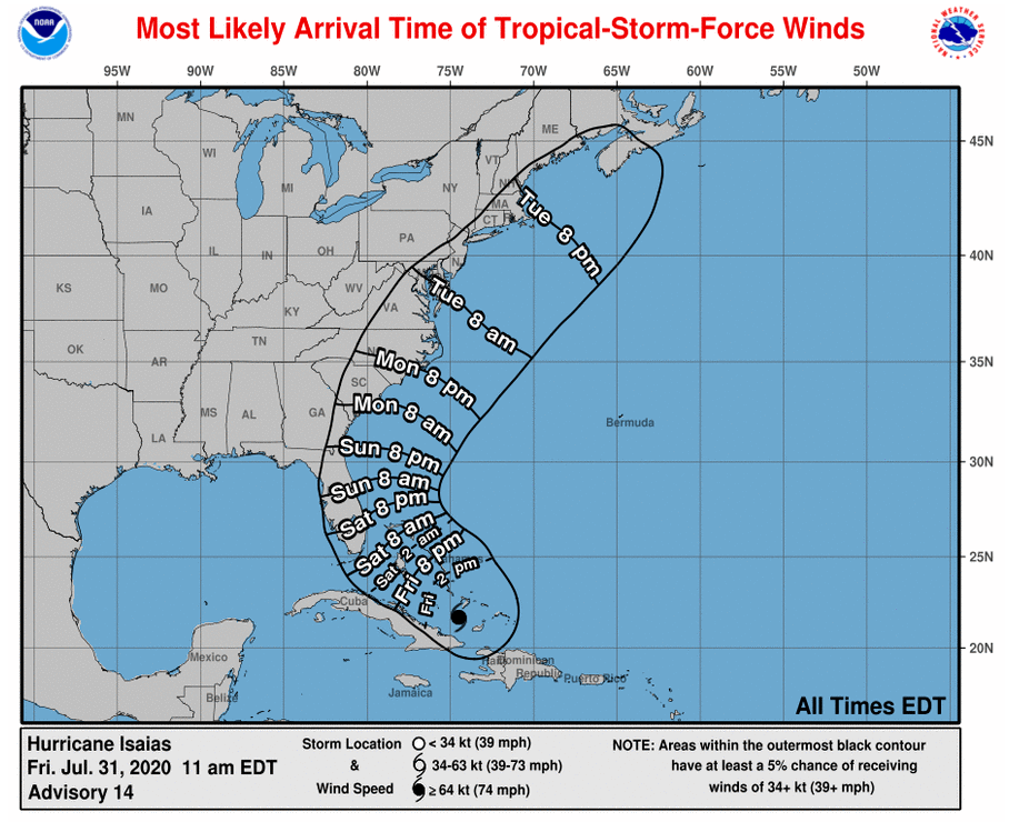
About a 25-35% chance that WDW will get 45 mph winds starting late Saturday night.
Rider
Well-Known Member
The initial motion remains northwestward or 305/12 kt. The 12Z
global models have once again made a westward shift due to the ridge
to the north of Isaias not weakening as quickly as expected. This is
partly due to the ridge being stronger than expected and a shortwave
trough over the central United States moving a little slower into
the southeastern U.S. than previously indicated. The UKMET and ECMWF
explicitly show Isaias making landfall in 36-48 hours along the
southeast Florida coast, but appear to weaken the system below
hurricane strength. The GFS similarly brings the cyclone close to
the southeast and east-central Florida coasts, but also as a
somewhat weaker system. In the 48 to 60-hour period, the cyclone is
forecast to move slowly north-northwestward and northward through a
break in the subtropical ridge extending westward from the Atlantic
across Florida and into the northern Gulf of Mexico. By that time,
however, Isaias is expected to weaken below hurricane strength due
to the combination of strong southwesterly vertical wind shear and
interaction the Florida peninsula. Around 72 hours, the cyclone
should accelerate northeastward and possibly strengthen some before
passing over eastern North Carolina on day 4, and across eastern New
England on day 5. The NHC track forecast lies close to a blend of
the consensus models TVCA and NOAA-HCCA and is east of the UKMET
and ECMWF with the system forecast to be stronger than those
models indicate. Due to the westward shift in the NHC forecast
track, a Hurricane Warning and Storm Surge Watch have been issued
for portions of the Florida east coast.
The center of Isaias is now located in the center of an expanding
CDO feature. The improved inner-core wind field and aforementioned
convective structure, along with very warm SSTs near 30C, should
support some strengthening overnight and early Saturday morning.
However, increasing southwesterly vertical wind shear is expected to
cause a gradual decrease in intensity by Sunday and continue into
early next week. The new official intensity forecast is a little
lower than the previous advisory and is near the higher end of the
intensity guidance.
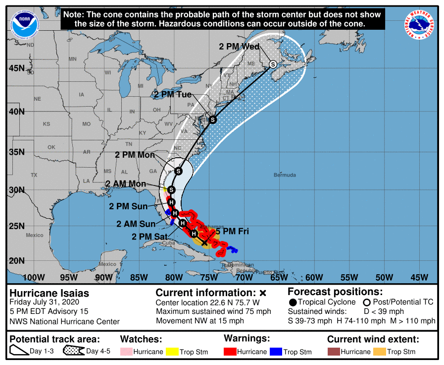
Tropical Storm Warnings for Orange and Osceola counties -
522 PM EDT Fri Jul 31 2020
...TROPICAL STORM WARNING IN EFFECT...
A Tropical Storm Warning means tropical storm-force winds are
expected somewhere within this area within the next 36 hours
* LOCATIONS AFFECTED
- Orlando
- Apopka
- Christmas
* WIND
- LATEST LOCAL FORECAST: Equivalent Tropical Storm force wind
- Peak Wind Forecast: 35-45 mph with gusts to 55 mph
- Window for Tropical Storm force winds: Saturday evening
until Sunday evening
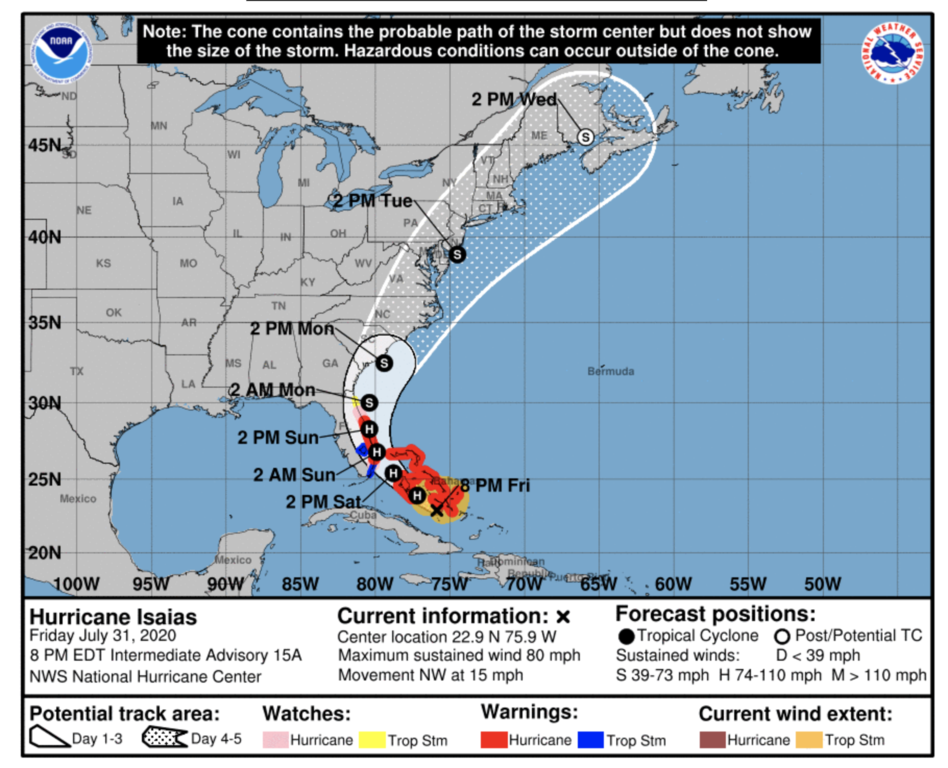
8pm track update -
DisneyCane
Well-Known Member
On the plus side, there isn't many tourists here, so the shutdown plans shouldn't be to hard.
Hopefully they will include reopen plans.
Shut down? Just shut down the outdoor attractions when lightning is in the area like usual. There were stronger storms at WDW on Wednesday than there will be from this storm.
Captain Barbossa
Well-Known Member
As long as there's enough beer, and Publix subs, I'm sure Floridians will be just fine.
Magic Feather
Well-Known Member
I’m under the impression that some offerings may have a slight shift in hours and the campground guests are being moved into solid buildings. That’s the extent of operations changes I’m expecting for this TS.
Register on WDWMAGIC. This sidebar will go away, and you'll see fewer ads.

