
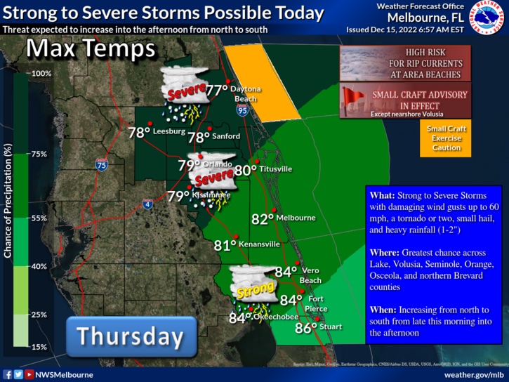
Tornado Watch issued for the Walt Disney World theme park area
Tornado Watch issued for the Walt Disney World theme park area
 www.wdwmagic.com
www.wdwmagic.com
www.wdwmagic.com
Radar Scope Pro, excellent!

 ), so I received the Tornado Watch alert earlier this morning. Too bad the app goes away after December 31…
Special Weather Statement
National Weather Service Melbourne FL
1213 PM EST Thu Dec 15 2022

FLZ044>046-144-151800-
Northern Lake County FL-Orange FL-Seminole FL-
Southern Lake County FL-
1213 PM EST Thu Dec 15 2022

...Strong thunderstorms will impact portions of west central
Seminole, southern Lake and western Orange Counties through 100 PM
EST...

At 1213 PM EST, Doppler radar was tracking strong thunderstorms along
a line extending from near Lake Apopka to 11 miles east of Dade City
to near Zephyrhills North. Movement was northeast at 40 mph.

HAZARD...Winds in excess of 40 mph.

SOURCE...Radar indicated.

IMPACT...Gusty winds could knock down tree limbs and blow around
         unsecured objects.

Locations impacted include...
Orlando, Apopka, Ocoee, Winter Garden and Eustis.

PRECAUTIONARY/PREPAREDNESS ACTIONS...

If outdoors, consider seeking shelter inside a building.

Torrential rainfall is also occurring with these storms and may lead
to localized flooding. Do not drive your vehicle through flooded
roadways.

A Tornado Watch remains in effect until 400 PM EST for east central
Florida.

&&

LAT...LON 2874 8195 2892 8145 2878 8142 2836 8149
      2835 8153 2835 8179 2836 8179 2836 8186
      2835 8186 2835 8196
TIME...MOT...LOC 1713Z 246DEG 37KT 2869 8166 2842 8202 2822 8210

MAX HAIL SIZE...0.00 IN
MAX WIND GUST...40 MPH

$$

SedlockSpecial Weather Statement
National Weather Service Melbourne FL
102 PM EST Thu Dec 15 2022
FLZ045-053-144-151845-
Osceola FL-Orange FL-Southern Lake County FL-
102 PM EST Thu Dec 15 2022
...Strong thunderstorms will impact portions of southwestern Lake,
southwestern Orange and northwestern Osceola Counties through 145 PM
EST...
At 101 PM EST, Doppler radar was tracking strong thunderstorms along
a line extending from Lake Louisa to 10 miles west of Four Corners to
6 miles northwest of Auburndale. Movement was northeast at 45 mph.
HAZARD...Wind gusts up to 50 mph.
SOURCE...Radar indicated.
IMPACT...Gusty winds could knock down tree limbs and blow around
unsecured objects.
Locations impacted include...
Orlando, Apopka, Ocoee, Winter Garden and Windermere.
PRECAUTIONARY/PREPAREDNESS ACTIONS...
If outdoors, consider seeking shelter inside a building.
Torrential rainfall is also occurring with these storms and may lead
to localized flooding. Do not drive your vehicle through flooded
roadways.
A Tornado Watch remains in effect until 400 PM EST for east central
Florida.
&&
LAT...LON 2875 8161 2848 8146 2826 8160 2826 8166
2835 8166 2835 8179 2836 8179 2836 8186
2835 8186 2835 8196 2836 8196
TIME...MOT...LOC 1801Z 225DEG 40KT 2850 8172 2836 8180 2817 8184
MAX HAIL SIZE...0.00 IN
MAX WIND GUST...50 MPH
$$
SedlockRegister on WDWMAGIC. This sidebar will go away, and you'll see fewer ads.