The Official Hurricane Ivan thread...

Mr D

New Member
Sponsored by


http://www.orlandosentinel.com/news...sep10,0,2968721.story?coll=orl-home-headlines
Fleeing Ivan's fury
In Florida Keys, flight from storm takes shape
By Maya Bell
Miami Bureau

September 10, 2004, 7:57 AM EDT

KEY LARGO -- Tourists and mobile-home residents began fleeing the Florida Keys on Thursday as Hurricane Ivan, the third storm to threaten the state in a month, took aim at the fragile island chain and perhaps the mainland as well.

The specter of a triple whammy worried Gov. Jeb Bush, who said, beyond preparation, there was but one thing to do.

"We can all pray," he said in Tallahassee. "And I intend to do some praying tonight that it redirects itself."

After leaving the tiny spice island of Grenada in ruins, Ivan was on course in the Caribbean to pound Jamaica today and threaten Cuba on Saturday.

From there, Ivan was projected to slow down during the weekend, becoming less predictable and prolonging the agony of a state still struggling to recover from back-to-back hurricanes Charley and Frances.

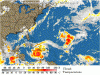
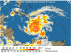
At 8 a.m., Ivan's eye was about 165 miles southeast of Kingston, Jamaica. Hurricane-force winds extended 50 miles, while tropical storm-force winds stretched 175 miles. Ivan was moving west-northwest at 13 mph and maximum sustained winds were near 145 mph.

"Florida is definitely in the picture," said Chris Hennon, a meteorologist at the National Hurricane Center west of Miami. "It's definitely within the realm of possibility it will impact some place in Florida."

Forecasters could not say where, when, or even if Hurricane Ivan would make landfall in Florida, but forecast models Thursday showed the Keys engulfed in Ivan's cone of uncertainty.

And after spending the day crunching gears between a powerful Category 4 and Category 5, the storm caught the attention of even the most hardy citizens of what is sometimes called the Conch Republic.

"From what I understand, a majority of people will leave this time because they've seen what happened with Charley and Frances," said Irene Toner, director of Monroe County's Emergency Management Office, after ordering her third evacuation of visitors and mobile-home dwellers in a month.

In fact, on Thursday many islanders were buttoning up their homes, hauling out their boats and gathering precious scrapbooks and other irreplaceables in anticipation of today's evacuation of the island chain's remaining 79,000 permanent residents.

Among them was Terry Schricker, 53, a retired electrical engineer for the National Oceanic and Atmospheric Administration. He said he spent half his life flying into the most ferocious storms with hurricane hunters who collect data for research and forecasts.

"Andrew [in 1992] was the first major hurricane I experienced on the ground, and I tell you what, I'd rather see them from the air," Schricker said as he packed his station wagon with a few belongings from his waterfront mobile home in Key Largo. "I know better than to stay. There's no question in my mind."

He and his wife, Kate, were far from alone. Most of the homes in Wynken, Blynken and Nod Estates, a collection of clap-trap mobile homes and million-dollar stilt houses on the Atlantic Ocean, were empty or nearly so.

Scott Silverson, 41, a lawyer who moved alone to a new job in the Keys a year ago, was packing his sport utility vehicle for the commute back to his family in Orlando, a journey that took him 14 hours before Frances' outer winds slapped the islands last week. Counting the coconuts, tires and other debris that Frances hurled in the canal behind his stilt home, he didn't hesitate undergoing the ordeal again.

"If a Category 1 did that, imagine what a Category 5 would do," Silverson said. "As they said in Ghostbusters, this is apocalyptic. . . . But, of course, there'll be some die-hard Conchs who will try to weather it."

And, of course, there were. Just next door, at Cindy's Hair Place, Barb Hussan 54, had no intention of closing, or leaving town.

"What evacuation?" she said, giving a teen-ager a spike cut. "I haven't left in 26 years. I'm in a very secure house. It's all concrete. I'm prepared."

Those who opt to stay behind had better be. Most stores were thin on basic supplies, such as water. At the Scotty's Hardware, sales clerk Bill Chaisson spent the afternoon turning customers away.

"I'm just answering the phone, telling people we don't have it," he said. "No plywood. No tarps. No generators. No propane. No duct tape."

Frank Woll, the owner of Florida Bay Outfitters, had the opposite problem. He had too many brand-new kayaks and canoes to haul north on his small trailer. He loaded up about 40 of his 250 inventory and hoped for the best.

"I don't have insurance," he said. "But I was already packed for Frances, so I'm getting out of here. Maybe I can sell them on the side of the road."

At the popular Hog's Breath Saloon, in downtown Key West, general manager Charlie Bauer was wondering how he would recover. He just had his worst six weeks since 1988.

"It's been a financial disaster since Charley, but it's hard to complain when the rest of the state is without air-conditioning," said Bauer, who normally doesn't budge, but will now. "I won't even hang around for a Category 3."

At Holiday Isle in Islamorada, the biggest resort in the Upper Keys, owner Scott Simmons said guests were leaving his 178-room hotel with little encouragement.

"Where do we send people is actually a question," Simmons said. "They don't know where to go: the east coast, the west coast or to Canada."

Tourism officials felt for the displaced evacuees and were hoping they weren't sending them into more misery.

"We're hoping there's power, we're hoping there's hotels, we're hoping there's gasoline wherever they go," said Andy Newman, a spokesman for Monroe County's tourism industry.

The last time a total evacuation of the Keys was ordered occurred in 2001, for Hurricane Michelle, a Category 4 storm with top sustained winds of 135 mph. It missed hitting the Keys directly. At that time, officials estimated that only 15 percent of the residents left.

At John Pennekamp Coral Reef State Park, where campers were rousted from their tents early Thursday morning, rangers were already preparing for what may come, including their eventual return.

"We're packing up all our computers, the stuff we can't replace and the stuff we'll need to get back -- like chain saws and generators," assistant park manager Bob Bodner said.

He remembers the eight long months it took for the last park he worked at, Bahia Honda State Park on Big Pine Key, to reopen after Hurricane Georges clobbered the Keys in 1998.

In Tallahassee, Bush said even National Guard troops are exhausted from two previous hurricanes, but Florida is accepting help from 25 states including California.

"We're going to redouble our efforts and prepare the best we can," Bush said. "This has been an incredible month."

Bob Mahlburg of the Sentinel staff and Mark Hollis, Noaki Schwartz and Robert Nolin of the South Florida Sun-Sentinel contributed to this report. Wire services also were used. Maya Bell can be reached at mbell@orlandosentinel.com or 305-810-5003.
Get home delivery - up to 50% off
 

Mr D

New Member
Hurricane Prediction Boggles Even Supercomputers
Landfall Targets Swing From Louisiana To Georgia
Where will Hurricane Ivan come ashore?


Supercomputers in facilities from Florida to Maryland to California have been trying to answer that question for days. Programmed with decades of hurricane history, updated with wind speed and barometric pressure and humidity from dozens of satellites, buoys and airplane-dropped sensors, they whir and process for an hour or more to produce -- on Thursday, at least -- this answer:

Anywhere from Louisiana on the west to Savannah, Ga., on the east. And maybe not there.

So when the humans at the National Hurricane Center produced a forecast track early Thursday showing Ivan coming through Orlando early next week, they also acknowledged that no one can say for sure when or where the storm will hit.

Orlando, the center said, at that time represented the middle course of a dozen or more computer models that show Ivan following paths west and east of Florida, as well as right up the spine of the state. But trying to predict the course of any hurricane five days out is beyond a supercomputer's abilities; even three-day forecasts can be hugely wrong, as Hurricane Charley showed last month.

"The further you get out into time [before landfall], the more the uncertainty," said hurricane-center meteorologist Gene Hafele.

Two of the biggest factors influencing the possible path of Ivan are a storm heading east through the Rocky Mountains and a high-pressure system in the Atlantic known as the Bermuda high, which typically is in place during the summer and early fall months.

If the storm moves the Bermuda high out into the Atlantic or weakens it, Ivan could head right into Florida and possibly to Orlando. If the Bermuda high strengthens or rebounds from the storm, Ivan could go west into the Gulf of Mexico. There is no agreement yet on what will happen, though the computers are "trending" toward the Bermuda high's staving off the storm.

"This is the stuff people spend decades and decades trying to understand," said Josh Darr, a meteorologist with Risk Management Solutions in California, a company that helps insurance companies forecast potential losses in a natural disaster such as a hurricane.

Forecasting Is Inexact Science

With tropical storm-force winds extending 175 miles from its eye, Ivan was headed north-northwest Thursday night. Earlier, its top winds were 160 mph, though it was expected to weaken after crossing Jamaica and, quite possibly, Cuba.

After that, the computers disagree on what happens next.

The reason: Forecasting is an inexact science that -- while growing in sophistication -- cannot take into account the myriad atmospheric factors that eventually determine the course of a storm.

Anything from the temperature of the water to a shifting high- or low-pressure system to wind shears to a hurricane's forward speed can alter the track and intensity of a storm.

The computer models, most fed with data from hurricanes as far back as 1900, try to consider countless nuances in producing a potential course. That's why they can change several times a day, whenever a new set of programs is run.

Although hundreds of hurricane-tracking programs are available or in development, the National Hurricane Center typically pays most attention to five models. They are called NOGAPS, AVN, BAM, UKMET and GFDL.

On Thursday, their plots showed Ivan could head as far west as Louisiana -- or as far east as the open Atlantic. These, and a few others, were averaged to produce a "consensus" track that showed Ivan passing near Orlando but later revised to show it passing west of Tampa.

"It's always better to have several opinions rather than just one," said Pete Dailey, a meteorologist and manager of atmospheric science for AIR Worldwide Corp., a risk-modeling agency in Boston.

Two of the most respected models are NOGAPS, produced by the U.S. Navy, and GFDL, created by a government-funded laboratory at Princeton University and run on National Weather Service supercomputers in Maryland.

Morris Bender, a research meteorologist at Princeton and a developer of the GFDL, said the model solves complex mathematical equations involving fluid dynamics to predict Earth's ever-changing environment.

"It's called a model because it's an approximation of the behavior of the atmosphere," Bender said of the GFDL, which stands for Geophysical Fluid Dynamics Laboratory and was developed in the 1970s. "You're trying to reproduce what the storm is doing, but much faster. The atmosphere is complicated, and nobody's model is perfect."

The GFDL prediction Thursday: Ivan would make landfall in Florida sometime Tuesday near Tampa.

NOGAPS, which stands for Navy Operational Global Atmospheric Prediction System, uses wind, temperature, humidity, barometric pressure and other atmospheric-profile data gathered worldwide by satellites, ships at sea, weather buoys, weather balloons, military and commercial aircraft. It's all crunched by a supercomputer in Monterey, Calif.

The NOGAPS prediction: Ivan would make landfall Tuesday somewhere west of Tallahassee.

"Different models make different assumptions, on how they form clouds, the convective energy in thunderstorms, how radiation is absorbed into the atmosphere. So the models will behave differently," explained Mike Clancy, chief scientist for the Navy's Fleet Numerical Meteorology and Oceanography Center.

"We don't understand the exact physics of the atmosphere," he added.That's no surprise to John Williams, a veteran Florida meteorologist and co-author of a book about Florida hurricanes and tropical storms.

"Babies like these," Williams said of Ivan, "have a mind of their own. They do what they want."

Copyright 2004 by Orlando Sentinel. All rights reserved. This material may not be published, broadcast, rewritten or redistributed.
 

Mr D

New Member
100853W5.gif
 

PhotoDave219

Well-Known Member
It keeps fluxuating between that track and the westward one. I like teh westward one better, BUT i thoink we're SOL. We'll know more tomorrow....
 
patelaine1953 said:
I thought September was the off season because of things like hurricanes. That's why it costs much less in points for DVC and also why you see so many really good deals for the resorts. The lowest offer I received was from Disney Visa for $49 per night for the month of Sept.

If that were the case then there would be discounts from June 1st to November 30th or all of hurricane season. September is the off season because:
1. Summer is over - kids are back in school
2. It is not a big holiday season
 

wannab@dis

Well-Known Member
who knows what it's gonna do. I think we're still a little early to really get a good picture of it. They have several models with it landing west of FL.

geez... kinda like a boxing match with this latest track... Left hook, right hook, now another left hook.
 

Tim G

Well-Known Member
<TABLE borderColor=#000000 cellSpacing=0 cellPadding=2 width="98%" border=1><TBODY><TR><TD bgColor=#ff0000><TABLE width="100%"><TBODY><TR><TD class=large>STORM STATUS</TD><TD class=small align=right>September 10, 7:34 AM EDT</TD></TR></TBODY></TABLE></TD></TR><TR><TD bgColor=#cccccc><TABLE cellSpacing=0 cellPadding=2 width="95%" border=0><TBODY><TR><TD colSpan=2>Name: Hurricane Ivan</TD></TR><TR><TD class=small vAlign=top>Location: About 165 miles, 270 km, Southeast of Kingston Jamaica.
Lat/Long: 16.3N, 74.7W
Max Winds: 145 mph
Category: 4
</TD><TD class=small vAlign=top noWrap>Heading: West-Northwest
Speed: 13 mph
Pressure: 27.58 inches
</TD></TR></TBODY></TABLE></TD></TR></TBODY></TABLE>
Florida Bracing For Potential Hit From Hutticane Ivan

Updated: 8:49 am EDT September 10,2004

MARATHON, Fla. -- Before Florida could catch a breath from a furious hurricane double-whammy, residents of the Keys were sent scurrying Friday under new evacuation orders as powerful Ivan took aim at the state

Residents of the lower Keys began leaving the 100-mile long island chain at dawn, hitting the mostly two-lane road to the mainland to escape Ivan, which was packing winds of 145 mph as it moved through the Caribbean.

Residents of the middle and upper Keys were being told to leave later Friday in a phased evacuation aimed at keeping the traffic flowing. The storm could hit Monday, and would be the third to hit Florida in a month.

Monroe County officials hope to have most of the islands' 79,000 residents evacuated by the end of the day, although the last mandatory evacuation in 2001 before Hurricane Michelle was ignored by 85 percent of residents. That Category 4 storm packing winds of 135 mph missed a direct hit on the Keys.
Laura Grace was filling up her gas tank and an extra container at a Key West gas station early Friday. She was leaning toward evacuating, but she wasn't sure anywhere in Florida would escape Ivan's wrath. She thought she might have to head out of state.
None of Florida's going to be safe. You have to plan on driving 12 hours. But I'll do it to get out of this storm," she said.

Mark Schoonover, who was buying cigarettes at the gas station, said he's staying put to take care of the homes and rental properties he manages.
"I've ridden out a few others but not a Category 5. That's why we live here -- for the weather," he said.

The National Hurricane Center said Ivan could hit the Keys as a Category 4 hurricane, with winds of 131 to 155 mph, as soon as late Monday, though there was still hope that the storm would move out into the Gulf of Mexico. If it strikes Florida, it could add to an already deadly and costly hurricane season for the state. Charley, which hit Aug. 13, and Frances, which hit Sunday, killed at least 43 people and caused up to $20 billion in combined damage.
Both missed the Keys, however.

"The first one was wide left, the second one was wide right, and this one looks like it's coming straight up the middle," said Buzz Wagner, controller at the Crane Point Nature Center in Marathon, which bills itself as the heart of the Keys. "I'm kind of perversely looking forward to it."
Ivan carried maximum sustained winds near 145 mph Friday, down slightly from 160 mph earlier Thursday. The powerful hurricane has already killed at least 23 people in the Caribbean and drew a bead on Jamaica, where officials urged a half million people to evacuate.

At 8 a.m. EDT, Ivan was about 165 miles southeast of Kingston, Jamaica, and heading west-northwest at 13 mph.
Meanwhile in South Florida, long lines reappeared at gas stations while shoppers snapped up hurricane supplies at home building stores and supermarkets in preparation for the possibility of a third strike in a month. The state has not been hit by three hurricanes in a single season since 1964.
 

WDWScottieBoy

Well-Known Member
Thanks for keeping us updated on the storm. I hope it stays away from FL and dissipates in the gulf. I'd hate to see this turn into another Andrew or worse. It looks like this is going to be bad. PLEASE stay safe everyone.
 

Tim G

Well-Known Member
Update Hurricane Ivan
Local Hurricane Statement

Statement as of 08:05 am EDT on September 10, 2004
Expires 03:30 PM EDT on 10 september, 2004

Mandatory evacuation of Lower Keys residents has begun as of 700 am.
Mandatory evacuation of Middle Keys residents to begin at noon...
Mandatory evacuation of visitors and non-residents...
Mandatory evacuation of recreational vehicles...
Mandatory evacuation of mobile homes...

New information since last issuance
Updated timing in the preparedness information. Storm information has been updated.

Areas affected
This statement is specific to the Florida Keys of Monroe County

Watches and warnings
No watches or warnings are in effect for the Florida Keys at this time.

Storm information
At 08.00 am EDT,the center of Hurricane Ivan was located near latitude 16.3 north, longitude 74.7 west, or about 165 miles southeast of Kingston Jamaica. This is about 730 miles southeast of Key West.
Maximum sustained winds were near 145 miles an hour, making Ivan a dangerous category four on the Saffir-Simpson scale.
Ivan is moving toward the west northwest near 13 miles an hour.
Minimum central pressure was measured at 934 mb... or 27.58 inches of Mercury.

Precautionary/preparedness actions
a phased mandatory evacuation of Keys residents is in effect.
Those from Key West to the 7-mile bridge should evacuate now, beginning at noon, residents of the Middle Keys should evacuate.

At 04:00 PM, residents of the Upper Keys should evacuate. Residents make sure you have your re-entry permit.
The shelter for Monroe County is located at Florida International University. Take U.S. 1 north to the Turnpike, then exit east on SW 8th street.
Follow the signs to the shelter, which will be open at 500 PM today.
Shelters in the Keys will not be open.

An evacuation of visitors, non-residents, recreational vehicles and mobile home residents is in effect.
Tolls at Card Sound Road and on the Florida Turnpike have been lifted.
The Monroe County information hot-line has the latest information.
They may be reached at 1 800 955 5504.

Key West International Airport will continue flight operations through tonight at least.
Check with your airline for your flight status.
Greyhound bus plans to continue service through tonight.
Extra departures have been scheduled.
Call 1 800 231 2222 for details.

The passenger Ferry to Fort Myers has a departure scheduled this afternoon. Call 305 294 4000 for details.
The authorities ask that you remain calm and listen for later instructions and recommendations.

Once again, the Monroe County emergency hot-line is 1 800 955 5504.
There is plenty of time to complete preparations for a major hurricane and evacuate the Keys, however, do not! We repeat, do not! wait until the last minute to evacuate.

Marine impacts
In order to allow vehicle traffic to proceed unimpeded, the bridges at Snake Creek and Jewfish Creek will be locked in the down position and thus closed to marine vessel traffic.

Next update
The next statement concerning Hurricane Ivan will be issued around 11:30 am.
 

Tim G

Well-Known Member
Hurricane Ivan Intermediate Advisory Number 32a

Issued at: 7:34 AM AST 9/10/04

Powerful ivan continues to move toward jamaica

A hurricane warning remains in effect for jamaica and the cayman islands.

A hurricane watch and a tropical storm warning remain in effect for the entire southwest peninsula of haiti from the border of the dominican republic westward, including port au prince.

A hurricane watch and a tropical storm warning are in effect for the dominican republic from barahona to perdenales. A tropical storm watch remains in effect for the southwestern coast of the dominican republic from palenque westward to barahona.

A hurricane watch is in effect for central and eastern cuba from matanzas eastward. Tropical storm or hurricane warnings may be required for portions of eastern cuba later this morning.

Interests in central and western caribbean sea should closely monitor the progress of dangerous hurricane ivan.

At 8 am ast, 1200z, the eye of hurricane ivan was located near latitude 16.3 north, longitude 74.7 west or about 165 miles, 270 km, southeast of kingston jamaica.

Ivan is moving toward the west-northwest near 13 mph, 20 km/hr. This motion is expected to bring the center of ivan to near jamaica tonight.

Maximum sustained winds remain near 145 mph, 230 km/hr, with higher gusts. Stronger winds, especially in gusts, are likely over elevated terrain. Some fluctuations in intensity are likely and ivan could become even stronger as it nears jamaica.

Hurricane force winds extend outward up to 50 miles, 85 km, from the center, and tropical storm force winds extend outward up to 175 miles, 280 km.

The latest minimum central pressure reported by a reconaaissance plane was 934 mb, 27.58 inches.

Storm surge flooding of 5 to 8 feet above normal tide levels, along with large and dangerous battering waves, can be expected near the center of ivan in the hurricane warning area.

Rainfall amounts of 6 to 10 inches, possibly causing life- threatening flash floods and mud slides, can be expected along the path of ivan.

Repeating the 8 am ast position, 16.3 n, 74.7 w. Movement toward, west-northwest near 13 mph. Maximum sustained winds, 145 mph. Minimum central pressure, 934 mb.

For storm information specific to your area, please monitor products issued by your local weather office.

The next advisory will be issued by the national hurricane center at 11 am ast.
 

Tim G

Well-Known Member
Update Hurricane Ivan
Atlantic I.R. Satellite Update

Image Delay = 60 Mins.
 

Attachments

  • Ivan at_ir_loop_06.gif
    Ivan at_ir_loop_06.gif
    424.7 KB · Views: 153

Tim G

Well-Known Member
Update Hurricane Ivan
Jamaican Visible Satellite Update

Image Delay = 45 Mins.
 

Attachments

  • jam_vi_anim01.gif
    jam_vi_anim01.gif
    864.4 KB · Views: 132

Tim G

Well-Known Member
Update Hurricane Ivan
Caribbean I.R. Satellite Update

Image Delay = 45 Mins.
 

Attachments

  • jam_ir_anim01.gif
    jam_ir_anim01.gif
    392.5 KB · Views: 128

wsapooh

New Member
Just got a "Disney Flash" .. it's an e-mail sent from Disney to travel agents. FYI for anyone who has travel plans coming up within the next few days...

Disney Destinations Hurricane Ivan Update

Friday, Sept. 10, Noon


Walt Disney World and Walt Disney Travel Company

Due to Hurricane Ivan, a temporary cancellation and "No Show" policy has been adopted for travel agents who have booked reservations through Walt Disney World or the Walt Disney Travel Company (agents that have booked through another tour operator should contact that company for its specific cancellation policy).

"No Show" penalties will be waived for any Client arrivals between Sunday, Sept. 12 and Thursday, Sept. 16, 2004.


Disney Cruise Line

With the scheduled re-opening of Port Canaveral this week, the Disney Magic and the Disney Wonder will depart from this home port as originally scheduled.

The Disney Magic will set sail on Saturday, Sept. 11, from Port Canaveral. Due to Hurricane Ivan's projected path through the Western Caribbean, Disney Cruise Line has modified this sailing to call on ports in the Eastern Caribbean including stops at St. Thomas and San Juan. Depending on the company's ability to complete beach restoration at Castaway Cay, the third port will be either Castaway Cay or Nassau on Friday, Sept. 17.

The 4-night Disney Wonder cruise will depart as planned on Sunday, Sept. 12, from Port Canaveral. The ship will sail to Nassau, spend the night, and allow clients to enjoy the next day at sea. The Disney Wonder will return to Port Canaveral on Sept. 16.

Disney Cruise Line continues to monitor the path of Hurricane Ivan and will keep agents updated on any operational changes that may occur as a result of its course.
 

TomDisney

Active Member
PhotoDave219 said:
It keeps fluxuating between that track and the westward one. I like teh westward one better, BUT i thoink we're SOL. We'll know more tomorrow....


I don't like the westward one!!!!
How about one that takes it east and completely missing Florida and the US Mainland? Let's all hope that this is the last hurricane thread we'll see on this board for quite some time to come.....
 

Tim G

Well-Known Member
<TABLE borderColor=#000000 cellSpacing=0 cellPadding=2 width="98%" border=1><TBODY><TR><TD bgColor=#ff0000><TABLE width="100%"><TBODY><TR><TD class=large>STORM STATUS</TD><TD class=small align=right>September 10, 10:50 AM EDT</TD></TR></TBODY></TABLE></TD></TR><TR><TD bgColor=#cccccc><TABLE cellSpacing=0 cellPadding=2 width="95%" border=0><TBODY><TR><TD colSpan=2>Name: Hurricane Ivan</TD></TR><TR><TD class=small vAlign=top>Location: About 155 miles, 245 km, Southeast of Kingston Jamaica.
Lat/Long: 16.5N, 75.1W
Max Winds: 145 mph
Category: 4
</TD><TD class=small vAlign=top noWrap>Heading: West-Northwest
Speed: 12 mph
Pressure: 27.58 inches
</TD></TR><TR><TD class=small align=middle colSpan=2></TD></TR></TBODY></TABLE></TD></TR></TBODY></TABLE>Hurricane Ivan Advisory Number 33

Issued at: 10:50 AM EDT 9/10/04

Dangerous hurricane ivan gradually approaching jamaica, expected to move slowly between the cayman islands and cuba.

A hurricane warning remains in effect for jamaica and the cayman islands.

A hurricane watch and a tropical storm warning remain in effect for the entire southwest peninsula of haiti from the border of the dominican republic westward, including port au prince.

At 11 am edt, 1500z, the government of cuba has issued a hurricane watch for the entire island and a tropical storm warning for the south coast of eastern cuba from cabo cruz to santiago de cuba.

At 11 am edt, 1500z, all warnings and watches have been discontinued for the dominican republic.

Interests in central and western caribbean sea should closely monitor the progress of dangerous hurricane ivan.

At 11 am edt, 1500z, the eye of hurricane ivan was located near latitude 16.5 north, longitude 75.1 west or about 155 miles, 245 km, southeast of kingston jamaica.

Ivan is moving toward the west-northwest near 12 mph, 19 km/hr. This motion is expected to bring the core of ivan to near jamaica tonight or early Saturday.

Maximum sustained winds are near 145 mph, 230 km/hr, with higher gusts. Stronger winds, especially in gusts, are likely over elevated terrain. Some fluctuations in intensity are likely during the next 24 hours.
Hurricane force winds extend outward up to 60 miles, 95 km, from the center, and tropical storm force winds extend outward up to 175 miles, 280 km.
Estimated minimum central pressure is 934 mb, 27.58 inches.
Storm surge flooding of 5 to 8 feet above normal tide levels, along with large and dangerous battering waves, can be expected near the center of ivan in the hurricane warning area.
Rainfall amounts of 6 to 10 inches, possibly causing life- threatening flash floods and mud slides, can be expected along the path of ivan.
Repeating the 11 am edt position, 16.5 n, 75.1 w. Movement toward, west-northwest near 12 mph. Maximum sustained winds, 145 mph. Minimum central pressure, 934 mb.


For storm information specific to your area, please monitor products issued by your local weather office.
An intermediate advisory will be issued by the national hurricane center at 2 pm edt followed by the next complete advisory at 5 pm edt.
 

Register on WDWMAGIC. This sidebar will go away, and you'll see fewer ads.

Back
Top Bottom