
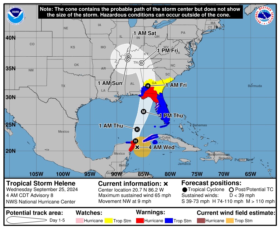
Judging by Radar and satellite, the center is about 40mi/64km off the coast.Down 12mb in 9 hrs. 6mb in last 3hrs. It's hard to tell because the radar down there sucks, but it looks like the center of the storm has stayed off sure, which doesn't help to weaken it at all. Once this thing clears the Yucatan, it's game on.
-
Welcome to the WDWMAGIC.COM Forums!
Please take a look around, and feel free to sign up and join the community.
You are using an out of date browser. It may not display this or other websites correctly.
You should upgrade or use an alternative browser.
You should upgrade or use an alternative browser.
Hurricane Helene (2024)
- Thread starter Gringrinngghost
- Start date
Captain Barbossa
Well-Known Member
11am (eastern) update:

Code:
000
WTNT34 KNHC 251457
TCPAT4

BULLETIN
Hurricane Helene Advisory Number   9
NWS National Hurricane Center Miami FL       AL092024
1000 AM CDT Wed Sep 25 2024

...HELENE BECOMES A HURRICANE...
...EXPECTED TO BRING LIFE-THREATENING STORM SURGE, DAMAGING WINDS,
AND FLOODING RAINS TO A LARGE PORTION OF FLORIDA AND THE
SOUTHEASTERN UNITED STATES...


SUMMARY OF 1000 AM CDT...1500 UTC...INFORMATION
-----------------------------------------------
LOCATION...21.6N 86.3W
ABOUT 85 MI...135 KM NNE OF COZUMEL MEXICO
ABOUT 500 MI...810 KM SSW OF TAMPA FLORIDA
MAXIMUM SUSTAINED WINDS...80 MPH...130 KM/H
PRESENT MOVEMENT...NNW OR 330 DEGREES AT 10 MPH...17 KM/H
MINIMUM CENTRAL PRESSURE...979 MB...28.91 INCHES


WATCHES AND WARNINGS
--------------------
CHANGES WITH THIS ADVISORY:

The Tropical Storm Warning has been extended northward along the
coasts of Georgia and South Carolina to South Santee River, and
westward along the Florida Gulf coast to the Okaloosa/Walton County
Line.

A Storm Surge Watch has been issued from Mexico Beach to Indian
Pass, Florida.

A Tropical Storm Watch has been issued along the coast of South
Carolina north of South Santee River to Little River Inlet.

SUMMARY OF WATCHES AND WARNINGS IN EFFECT:

A Storm Surge Warning is in effect for...
* Indian Pass southward to Flamingo
* Tampa Bay
* Charlotte Harbor

A Hurricane Warning is in effect for...
* Anclote River to Mexico Beach
* Cabo Catoche to Tulum, Mexico including Cozumel

A Storm Surge Watch is in effect for...
* West of Indian Pass to Mexico Beach

A Hurricane Watch is in effect for...
* Cuban province of Pinar del Rio
* Englewood to Anclote River, including Tampa Bay

A Tropical Storm Warning is in effect for...
* Florida Keys, including the Dry Tortugas
* Flamingo to Anclote River, including Tampa Bay
* West of Mexico Beach to the Okaloosa/Walton County Line
* Flamingo northward to South Santee River
* Lake Okeechobee
* Rio Lagartos to Cabo Catoche, Mexico
* Cuban provinces of Artemisa, Pinar del Rio, and the Isle of Youth

A Tropical Storm Watch is in effect for...
* North of South Santee River to Little River Inlet

A Storm Surge Warning means there is a danger of life-threatening
inundation, from rising water moving inland from the coastline,
during the next 36 hours in the indicated locations. For a
depiction of areas at risk, please see the National Weather
Service Storm Surge Watch/Warning Graphic, available at
hurricanes.gov.  This is a life-threatening situation.  Persons
located within these areas should take all necessary actions to
protect life and property from rising water and the potential for
other dangerous conditions.  Promptly follow evacuation and other
instructions from local officials.

A Hurricane Warning means that hurricane conditions are expected
somewhere within the warning area.  A warning is typically issued
36 hours before the anticipated first occurrence of
tropical-storm-force winds, conditions that make outside
preparations difficult or dangerous.  Preparations to protect life
and property should be rushed to completion.

A Tropical Storm Warning means that tropical storm conditions are
expected somewhere within the warning area within the next 36 hours.

A Storm Surge Watch means there is a possibility of life-
threatening inundation, from rising water moving inland from the
coastline, in the indicated locations during the next 48 hours.
For a depiction of areas at risk, please see the National Weather
Service Storm Surge Watch/Warning Graphic, available at
hurricanes.gov.

A Hurricane Watch means that hurricane conditions are possible
within the watch area.  A watch is typically issued 48 hours
before the anticipated first occurrence of tropical-storm-force
winds, conditions that make outside preparations difficult or
dangerous.

A Tropical Storm Watch means that tropical storm conditions are
possible within the watch area.

Additional watches or warnings may be required later today.

For storm information specific to your area in the United
States, including possible inland watches and warnings, please
monitor products issued by your local National Weather Service
forecast office. For storm information specific to your area
outside of the United States, please monitor products issued by
your national meteorological service.


DISCUSSION AND OUTLOOK
----------------------
At 1000 AM CDT (1500 UTC), the center of Hurricane Helene was
located near latitude 21.6 North, longitude 86.3 West.  Helene is
moving toward the north-northwest near 10 mph (17 km/h).  A turn
toward the north and north-northeast with an increase in forward
speed is expected later today through Thursday, bringing the center
of Helene across the eastern Gulf of Mexico and to the Florida Big
Bend coast by Thursday evening.  After landfall, Helene is expected
to slow down and turn toward the northwest over the southeastern
United States Friday and Saturday.

Data from NOAA and Air Force Reserve Hurricane Hunter aircraft
indicate that maximum sustained winds have increased to near 80 mph
(130 km/h) with higher gusts.  Additional strengthening is
forecast, and Helene is expected to be a major hurricane when it
reaches the Florida Big Bend coast Thursday evening.  Weakening is
expected after landfall, but Helene's fast forward speed will allow
strong, damaging winds, especially in gusts, to penetrate well
inland across the southeastern United States, including over the
higher terrain of the southern Appalachians.

Hurricane-force winds extend outward up to 25 miles (35 km) from the
center and tropical-storm-force winds extend outward up to 275 miles
(445 km).

The minimum central pressure based on dropsonde is 979 mb (28.91
inches).


HAZARDS AFFECTING LAND
----------------------
Key Messages for Helene can be found in the Tropical Cyclone
Discussion under AWIPS header MIATCDAT4 and WMO header WTNT44 KNHC
and on the web at hurricanes.gov/text/MIATCDAT4.shtml

STORM SURGE: The combination of a dangerous storm surge and the
tide will cause normally dry areas near the coast to be flooded by
rising waters moving inland from the shoreline.  The water could
reach the following heights above ground somewhere in the indicated
areas if the peak surge occurs at the time of high tide...

Carrabelle, FL to Chassahowitzka, FL...10-15 ft
Chassahowitzka, FL to Anclote River, FL...6-10 ft
Indian Pass, FL to Carrabelle, FL...6-10 ft
Anclote River, FL to Middle of Longboat Key, FL...5-8 ft
Tampa Bay...5-8 ft
Middle of Longboat Key, FL to Englewood, FL...4-7 ft
Englewood, FL to Flamingo, FL...3-5 ft
Charlotte Harbor...3-5 ft

For a complete depiction of areas at risk of storm surge inundation,
please see the National Weather Service Peak Storm Surge Graphic,
available at hurricanes.gov/graphics_at4.shtml?peakSurge.

Storm surge could raise water levels by as much as 2 to 4 feet above
normal tide levels in areas of onshore winds along the southern
coast of Pinar del Rio, Cuba, including the Isle of Youth.

Storm surge could raise water levels by as much as 2 to 4 feet above
ground level in areas of onshore winds within the warning area along
the east coast of the Yucatan Peninsula.

WIND: Hurricane conditions are expected within the U.S. hurricane
warning area late Thursday, with tropical storm conditions
beginning Thursday morning.  Tropical storm conditions are
expected in southern Florida later today and will spread northward
across the rest of Florida, Georgia, and South Carolina through
Thursday.  Tropical storm conditions are possible within the
tropical storm watch area in South Carolina beginning on Thursday.

Hurricane conditions, especially in gusts, are expected in the
hurricane warning area in Mexico during the next several hours.
Tropical storm conditions are occurring in the warning area in Cuba,
and hurricane conditions are possible for the western portion of
Cuba today.

RAINFALL: Helene is expected to produce total rain accumulations of
4 to 8 inches over western Cuba, the Cayman Islands, and the
northeast Yucatan Peninsula, with isolated totals around 12 inches.
This rainfall brings a risk of considerable flooding.

Over the Southeastern U.S. into the Southern Appalachians, Helene
is expected to produce total rain accumulations of 5 to 10 inches
with isolated totals around 15 inches. This rainfall will likely
result in areas of considerable flash and urban flooding, with areas
of significant river flooding. Landslides are possible in areas of
steep terrain in the southern Appalachians.

For a complete depiction of forecast rainfall associated with
Helene, please see the National Weather Service Storm Total Rainfall
Graphic, available at hurricanes.gov/graphics_at4.shtml?rainqpf and
the Flash Flood Risk graphic at
hurricanes.gov/graphics_at4.shtml?ero.

TORNADOES: A tornado or two may occur tonight over parts of the
Florida Peninsula and southern Alabama. The risk of tornadoes will
increase on Thursday, expanding northward across Florida into parts
of Georgia and South Carolina.

SURF: Swells generated by Helene will affect the southern coast of
Cuba and the Yucatan Peninsula of Mexico during the next couple of
days.  Swells will spread northward toward the west coast of Florida
and the northeastern Gulf Coast later today and Thursday. These
swells are likely to cause life-threatening surf and rip current
conditions.  Please consult products from your local weather office.


NEXT ADVISORY
-------------
Next intermediate advisory at 100 PM CDT.
Next complete advisory at 400 PM CDT.

$$
Forecaster BergJohnD
Well-Known Member
Yep. I work for the state and offices close at noon. I'm driving home, picking up my packed stuff from the living room, and hitting the road for Jax.The 10am update moved it more west, with a direct hit on Tallahassee. Better for WDW and Tampa Bay, but not for the capitol.
IanDLBZF
Well-Known Member
In addition, Universal announced that Volcano Bay will be closed tomorrow as well.According to updated operational hours, Typhoon Lagoon will be closed tomorrow, Thursday, October 26.
Disney Announces First Closures for Walt Disney World Due to Tropical Storm Helene
Disney Announces First Closures for Walt Disney World Due to Tropical Storm Helene
Disney Announces First Closures for Walt Disney World Due to Tropical Storm Helene
 www.wdwmagic.com
Mini golf also closed.
Disney Announces First Closures for Walt Disney World Due to Tropical Storm Helene
Disney Announces First Closures for Walt Disney World Due to Tropical Storm Helene
Disney Announces First Closures for Walt Disney World Due to Tropical Storm Helene
Mini golf also closed.
LSLS
Well-Known Member
Yeah, I remember some models having it drop to like 888 and even the experts questioned if there was something wrong with the model, just because it'd have to drop so much so fast. Think everyone is hoping it's wrong.It is doing exactly what the EXPERTS said it would.
A Cat 3 125mph 15 ft storm surge is life threatening and hopefully all residents and tourists heeded the orders to mandatory evac in the (3) coastal countries expected to take the direct hit.The 10am update moved it more west, with a direct hit on Tallahassee. Better for WDW and Tampa Bay, but not for the capitol.
And now tomorrow’s Mickey’s Not So Scary Halloween Party is cancelled. Magic Kingdom park hours were extended to an 8pm close.

Mickey's Not-So-Scary Halloween Party Canceled Due to Hurricane Helene, Magic Kingdom Hours Adjusted
Walt Disney World has announced that Mickey's Not-So-Scary Halloween Party scheduled for September 26th has been canceled
Here is the latest update from Walt Disney World on park operations:
Monitoring Hurricane Helene
Walt Disney World Resort is currently operating under normal conditions; however, some experiences will be cancelled or unavailable on September 26. See details below.
We are closely monitoring the path of the storm as we continue to prioritize the safety of our Guests and Cast Members.
Walt Disney World Water Parks
Disney’s Typhoon Lagoon water park is temporarily closed on Thursday, September 26 (Disney’s Blizzard Beach water park is currently closed for the season).
Beachcomber Shack (cabanas) and Typhoon Lagoon Umbrella rentals are cancelled for Thursday, September 26.
Tours & Enchanting Extras Collection
The following tours and Enchanting Extras Collection experiences are cancelled for Thursday, September 26:
Miniature golf courses at Walt Disney World Resort are temporarily closed on Thursday, September 26. These include:
Pools at Disney Resort hotels will continue to operate or close under normal conditions.
Monitoring Hurricane Helene
Walt Disney World Resort is currently operating under normal conditions; however, some experiences will be cancelled or unavailable on September 26. See details below.
We are closely monitoring the path of the storm as we continue to prioritize the safety of our Guests and Cast Members.
Walt Disney World Water Parks
Disney’s Typhoon Lagoon water park is temporarily closed on Thursday, September 26 (Disney’s Blizzard Beach water park is currently closed for the season).
Beachcomber Shack (cabanas) and Typhoon Lagoon Umbrella rentals are cancelled for Thursday, September 26.
Tours & Enchanting Extras Collection
The following tours and Enchanting Extras Collection experiences are cancelled for Thursday, September 26:
- Savor the Savanna
- Up Close with Rhinos
- Walking with Giants
- Wild Africa Trek
Miniature golf courses at Walt Disney World Resort are temporarily closed on Thursday, September 26. These include:
- Fantasia Gardens and Fairways Miniature Golf
- Winter Summerland Miniature Golf
Pools at Disney Resort hotels will continue to operate or close under normal conditions.
Captain Barbossa
Well-Known Member
2pm (eastern) update:

Yodasnuggs
Active Member
I’m here myself till Friday so well aware. Just saying we have people always making wild predictions every time there’s the possibility of a hurricane, and viewers of this thread trying to figure things out for their trip should be reminded that everything posted here is speculative. Heck last time we had people recommending people look up where storm shelters were for what turned out to be a wet afternoon.
Dumb question, but as a person with tickets to this, where do you see the cancelation on the app and/or website?And now tomorrow’s Mickey’s Not So Scary Halloween Party is cancelled. Magic Kingdom park hours were extended to an 8pm close.
Not doubting you, just have a sort of annoyed husband and want to show him the proof of cancelation

It will show up eventually, but it is confirmedDumb question, but as a person with tickets to this, where do you see the cancelation on the app and/or website?
Not doubting you, just have a sort of annoyed husband and want to show him the proof of cancelation

Walt Disney World Cancels Mickey's Not-So-Scary Halloween Party Due to Hurricane Helene, Adjusts Magic Kingdom Hours
Walt Disney World Cancels Mickey's Not-So-Scary Halloween Party Due to Hurricane Helene, Adjusts Magic Kingdom Hours
www.wdwmagic.com
Last edited:
Register on WDWMAGIC. This sidebar will go away, and you'll see fewer ads.