Alberto Cometh

mousermerf

Account Suspended
Original Poster
Well.. it's started raining in West Central Florida. It's already a pretty good drenching and they've issued the following:

HURRICANE LOCAL STATEMENT NATIONAL WEATHER SERVICE TAMPA BAY AREA - RUSKIN FL 1130 PM EDT SUN JUN 11 2006


...TROPICAL STORM ALBERTO HEADED FOR THE SUNCOAST...

...NEW INFORMATION... RAINFALL TOTALS ARE NOW EXPECTED TO BE 5 TO 10 INCHES ACROSS MOST OF THE AREA. THE ONSET OF TROPICAL STORM FORCE WINDS IS NOW EARLIER...WITH COASTAL LOCATIONS STARTING LATE MONDAY EVENING AND INLAND LOCATIONS BY TUESDAY MORNING.

...AREAS AFFECTED... THIS STATEMENT IS FOR RESIDENTS AND VISITORS TO SOUTHWEST AND WEST CENTRAL FLORIDA.

...WATCHES/WARNINGS... A TROPICAL STORM WATCH HAS BEEN ISSUED FOR COASTAL AREAS OF LEE... CHARLOTTE... DESOTO...SARASOTA...MANATEE... HILLSBOROUGH...PINELLAS... PASCO... HERNANDO...CITRUS AND LEVY COUNTIES.
AN INLAND TROPICAL STORM WATCH HAS BEEN ISSUED FOR NON COASTAL AND NON TIDAL LOCATIONS OF PINELLAS... HILLSBOROUGH...POLK...SUMTER PASCO... HERNANDO...CITRUS AND LEVY COUNTIES.

A FLOOD WATCH REMAINS IN EFFECT THROUGH TUESDAY MORNING FOR LEE... CHARLOTTE...SARASOTA...DESOTO... HARDEE...HIGHLANDS...MANATEE... PINELLAS...HILLSBOROUGH...POLK... PASCO...HERNANDO...CITRUS...LEVY AND SUMTER COUNTIES.

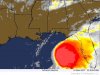
...STORM INFORMATION... AT 11 PM EDT... THE CENTER OF TROPICAL STORM ALBERTO WAS LOCATED NEAR LATITUDE 25.3 NORTH... LONGITUDE 87.7 WEST...OR ABOUT 370 MILES SOUTHWEST OF TAMPA. ALBERTO WAS MOVING NORTH-NORTHEAST NEAR 8 MPH AND A GRADUAL TURN TO THE NORTHEAST IS EXPECTED DURING THE NEXT 24 HOURS.

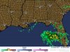
...WINDS... BRIEF THUNDERSTORM WIND GUSTS OF 40 TO 50 MPH ARE POSSIBLE THROUGH MONDAY AS THE RAIN BANDS FROM ALBERTO BLOW THROUGH. COASTAL AREAS COULD SEE SUSTAINED TROPICAL STORM FORCE WINDS BY EARLY TUESDAY MORNING. THE BEST CHANCE FOR INLAND TROPICAL STORM FORCE WINDS WILL BE ALONG AND NORTH OF INTERSTATE 4 BY MID TUESDAY MORNING.

...STORM SURGE AND STORM TIDE... TIDES WILL BE 1 TO 2 FEET ABOVE NORMAL THROUGH MONDAY NIGHT. THE HIGH TIDE ON TUESDAY AFTERNOON COMBINED WITH THE SURGE FROM ALBERTO COULD CAUSE COASTAL FLOODING FROM TAMPA BAY NORTH THROUGH CEDAR KEY. THE STORM SURGE JUST TO THE RIGHT OF WHERE ALBERTO MAKES LANDFALL COULD REACH 4 TO 6 FEET ABOVE THE NORMAL TIDE.

...INLAND FLOODING... TOTAL RAIN FALL THROUGH TUESDAY WILL BE 5 TO 10 INCHES. RECENT DRY CONDITIONS WILL ALLOW THE GROUND TO ABSORB A SIGNIFICANT AMOUNT OF RAINFALL. HOWEVER...HEAVY BURSTS OF RAIN MAY CAUSE FLOODING OF STREETS AND LOW LYING AREAS...ESPECIALLY IN URBAN AREAS.

...TORNADOES... ISOLATED TORNADOES ARE POSSIBLE IN THE OUTER RAIN BANDS OF TROPICAL STORM ALBERTO THROUGH TUESDAY.

...BEACH EROSION... SWELLS FROM ALBERTO WILL CAUSE BREAKING WAVES OF 4 TO 7 FEET THROUGH MONDAY. ONSHORE WINDS WILL DEVELOP TUESDAY WITH HIGH SURF AND MINOR BEACH EROSION EXPECTED. RIP CURRENTS WILL BE A THREAT THROUGH TUESDAY.

...PROBABILITY OF HURRICANE/TROPICAL STORM CONDITIONS... TROPICAL STORM ALBERTO IS A DISORGANIZED STORM AND FUTURE FORECASTS MAY HAVE SIGNIFICANT CHANGES TO THE TIMING LOCATION. CONTINUE TO MONITOR LATER FORECASTS.
...NEXT STATEMENT... THE NEXT HURRICANE LOCAL STATEMENT FROM THE NATIONAL WEATHER SERVICE IN RUSKIN WILL BE ISSUED BY 530 AM THIS MORNING OR SOONER IF CONDITIONS WARRANT.
 

Tim G

Well-Known Member
5day_640x480.jpg
 

Tim G

Well-Known Member
Atlantic Tropical Storm
Tropical Storm Alberto Intermediate Advisory Number 8a

Issued at: 12:39 AM CDT 6/12/06 (gateway).

Alberto remains disorganized over the central gulf of mexico,

A tropical storm watch is in effect for the west coast of Florida from north of bonita beach to steinhatchee.

For storm information specific to your area, including possible inland watches and warnings, please monitor products issued by your local weather office.

At 100 am cdt, 0600z, the center of the broad circulation of tropical storm alberto was estimated near latitude 25.4 north, longitude 87.7 west or about 340 miles, 550 km, south-southwest of apalachicola Florida and about 385 miles, 620 km, southwest of cedar key Florida.

Alberto is moving toward the north-northeast near 6 mph, 10 km/hr, and a turn toward the northeast is expected during the next 12 to 24 hours.

Maximum sustained winds are near 45 mph, 75 km/hr, with higher gusts. Little change in strength is expected during the next 24 hours.

Tropical storm force winds are confined to the eastern semicircle of alberto and extend outward up to 230 miles, 370 km, from the center.

The minimum central pressure recently reported by an air force reserve reconnaissance aircraft was 1006 mb, 29.71 inches.

Alberto is expected to produce total rainfall accumulations of 10 to 20 inches over the western half of cuba, with isolated totals of 30 inches over the higher terrain. These rains could produce life-threatening flash floods and mud slides. Rainfall is expected to begin to diminish across western cuba tonight. Rainfall totals of 5 to 10 inches are possible over the Florida peninsula through tuesday, with 3 to 5 inches possible in the Florida keys.

Tide levels are already running more than a foot above normal along the west coast of Florida from the tampa bay area northward to apalachicola. Coastal storm surge flooding up to 5 feet above normal tide levels can be expected along the Florida coast within and possibly to the north of the tropical storm watch area.

Repeating the 100 am cdt position, 25.4 n, 87.7 w. Movement toward, north-northeast near 6 mph. Maximum sustained winds, 45 mph. Minimum central pressure, 1006 mb.
 

Tim G

Well-Known Member
Tropical Storm Alberto Spins Toward Florida

UPDATED: 6:13 pm EDT June 11, 2006

TAMPA, Fla. -- Tropical Storm Alberto, the first named storm of the 2006 Atlantic hurricane season, developed Sunday in the Gulf of Mexico and appeared likely to soak parts of Florida and Cuba with heavy rain, forecasters said.

On Sunday afternoon, the storm had maximum sustained winds near 45 mph, up 10 mph from early in the morning, but was not likely to strengthen into a hurricane, according to the National Hurricane Center.

Most of Florida's west coast is under a tropical storm watch.

"We do not have any significant changes," said Lixion Avila, a senior hurricane specialist. "The system remains poorly organized."

Alberto is a lopsided tropical storm with the most intense wind and rains massed on the eastern edge of the system, Avila said. The first of the storm's rains swept across the Florida peninsula Sunday with no major reports of damage.

Forecasters said up to 10 to 20 inches of rain could fall over the western half of Cuba, creating a threat of flash floods and mudslides, and 5 to 10 inches could fall over the Florida Keys and the state's Gulf Coast.

The prospect of a wet storm without hurricane-force winds was welcomed by firefighters who have been battling wildfires for six weeks on Florida's east coast.

"A good soaking rain would do a lot to help stop the fires in our area," said Pat Kuehn, a spokeswoman for Volusia County Fire Services. "It has been a hard fire season. We've had several fires a week here."

The storm's outer rainbands swept across Florida from Miami to the Tampa Bay area Sunday afternoon, said National Weather Service meteorologist Richard Rude.

Patricia Haberland, whose back porch in St. Petersburg was flooded by 12 inches of rain in March, put a few valuables in plastic bins this weekend just to be on the safe side.

"Other than that, we're carrying on as usual, going to work, going to church," said Haberland, 52. "It doesn't look like it's going to have a major impact on our area."

Though the storm was not expected to cross the Florida Keys, some tourists were not taking any chances in the low-lying island chain.

"I had a bunch of people check out this morning because of the massive tropical storm that was supposed to swamp the island," said Nikki LaMarca, front desk manager at Courtney's Place in Key West. "It's amazing. People are actually leaving."

At 5 p.m. EDT, Alberto was centered about 375 miles west of Key West and about 400 miles south-southwest of Apalachicola, forecasters said.

It was moving northwest at 7 mph but was expected to turn toward central or northern Florida, where it could make landfall early Tuesday, forecasters said.

The tropical depression that produced Alberto formed Saturday, nine days after the official start of the hurricane season, in the northwest Caribbean, which can produce typically weak storms that follow a similar track this time of year, forecasters said.

"They can also meander in the Gulf for awhile, and we've seen some dissipate before reaching any land areas," Pasch said. "There is no guarantee (Alberto) will make landfall."

Scientists predict the 2006 season could produce up to 16 named storms, six of them major hurricanes.

Last year's hurricane season was the most destructive on record. Hurricane Katrina devastated Louisiana and Mississippi and was blamed for more than 1,570 deaths among Louisiana residents alone.

The season was the busiest in 154 years of storm tracking, with records for the number of named storms (28) and hurricanes (15). Meteorologists used up their list of 21 proper names - beginning with Arlene and ending with Wilma - and had to use the Greek alphabet to name storms for the first time.

Meteorologists have said the Atlantic is not as warm now as it was at this time in 2005, meaning potential storms would have less of the energy needed to develop into hurricanes.

Last year, the first named storm of the season was Tropical Storm Arlene, which formed June 9, 2005, and made landfall just west of Pensacola in the Florida Panhandle - the first of two tropical storms and four hurricanes to target Florida last year.
 

Figment1986

Well-Known Member
it's already here I feel it.. tornado county below me near my school.. (let alone we still have college classes today and tomorrow acroding to the website... Evil college!)

Doesn't a warning mean close school?? even if it is TS!

Hope the rain though remains somewhat the keep this drought condtions low.. just dont hurt anyone.. or make my lawn grow that much...
 

Tim G

Well-Known Member
Figment1986 said:
it's already here I feel it.. tornado county below me near my school.. (let alone we still have college classes today and tomorrow acroding to the website... Evil college!)

Doesn't a warning mean close school?? even if it is TS!

Hope the rain though remains somewhat the keep this drought condtions low.. just dont hurt anyone.. or make my lawn grow that much...
Hurricane Warning... YES
Tropical Storm Warning ... NO

Althought there has been a Hurricane Watch Issued for several counties...

Just follow the news on TV or Radio...
 

mousermerf

Account Suspended
Original Poster
How long have you been in FL figgy?

If we closed down for every tropical storm we'd never have school ;) As it is, shutting down for Hurricanes, only when Cat 1 conditions or higher are expected within the next 24 hours, has severely screwed up schedules.

Word of wisdom - always check the school website before heading out to class. They've canceled classes midday before.
 

Tim G

Well-Known Member
Hurricane Warning Issued As Alberto Heads Toward Florida

TAMPA, Fla. - Parts of Florida's Gulf Coast were under a hurricane warning Monday as the first named storm of the 2006 Atlantic hurricane season quickly and unexpectedly gained strength,
with forecasters warning that Tropical Storm Alberto could flood some areas with storm surge of up to 10 feet.

Floridians had expected Alberto to be an easy start to the season, which began less than two weeks ago.
But forecasters said it was possible that Alberto could become a hurricane before its expected landfall Tuesday morning,
although they didn't originally expect it to strengthen to that level.

At 2 p.m. EDT, Alberto's top sustained winds were 70 mph, just 4 mph shy of hurricane strength and up from 50 mph in the morning.
The storm was centered about 180 miles southwest of Cedar Key and was moving northeast at about 10 mph, National Hurricane Center forecasters said.

The hurricane warning stretched about 200 miles from Longboat Key near Sarasota to the Ochlockonee River south of Tallahassee.
It means Alberto was expected to produce hurricane conditions by late Tuesday morning.

Rain was already falling in the state and two tornados were sighted,
although there were no reports of injuries or damage.
Gov. Jeb Bush signed a declaration of emergency for the state early Monday,
which allows him to call up the National Guard and put in place laws against price gouging.
"This potentially could be a hurricane, it has a potential wide impact for a lot of people in our state," Bush told the emergency response team monitoring the storm in Tallahassee. "Let's all just get to work."

Forecasters were predicting coastal storm surges of 8 feet to 10 feet, with flooding possible along an extensive portion of the Gulf Coast.
"Put aside whether it's a tropical storm or a hurricane.
The difference between 60 mph winds and 70 mph winds, I'm not sure how much that changes surges of water coming off the coast," Bush said.
Craig Fugate, Florida's emergency management director, compared the situation to the winter storm of 1993, a surprise "no-name" storm that caused 12-foot storm surges and killed 44 Floridians. This time, though, he said, residents have time to evacuate.
"This is not an area of the coast that takes days to evacuate. It takes hours," he said.

In St. Petersburg, staff at a marina said they planned to work through the night adjusting lines to secure the 610 boats docked there.
"This is a little earlier that I expected," said St. Petersburg Marina and Port Manager Walter Miller.
"But we've had a bad couple of years, so it's not entirely unexpected."
Tropical storm-force wind stretched up to 230 miles from the center, so powerful gusts may be felt long before Alberto makes landfall.

Already, a tornado was spotted in Hardee County and the other in Polk County, said Jud Ladd, a meteorologist for the National Weather Service in Ruskin.

Alberto was expected to bring 4 to 10 inches of rain in parts of central Florida up to southeastern Georgia.
The rains would be welcome in parched parts of the state, some of which have been hit by wildfires.
The majority of Florida, from north of Fort Lauderdale to the Panhandle area is anywhere at a quarter to half of normal rain levels, according to Jud Ladd, meteorologist at the National Weather Service in Ruskin.

Experts had raised concerns about the ability of the dike surrounding Lake Okeechobee to withstand heavy rains, but Bush said that due to the low level of the lake, about 12-feet above sea level, no immediate threat existed.
The tropical depression that produced Alberto formed Saturday, nine days after the official start of the hurricane season, in the northwest Caribbean. It became a named storm when its sustained winds reached 39 mph. Heavy rain from Alberto drenched Havana, Cuba, and Pinar del Rio province to the west throughout the weekend, causing some minor street flooding.

Scientists say the 2006 season could produce as many as 16 named storms, six of them major hurricanes.
 

Tim G

Well-Known Member
Tropical Storm Alberto

Location: About 155 miles, south of apalachicola Florida and about 180 miles, Southwest of Cedar Key Florida.
Lat/Long: 27.5N, 85.4W
Max Winds: 70 mph
Heading: North-Northeast
Speed: 10 mph
Pressure: 29.44 inches

18 counties are now under advisories, watches, or severe weather warnings.

Please Click below!

Northern Brevard County
Southern Brevard County
Citrus County
Flagler County
Hardee County
Hernando County
Highlands County
Indian River County
Northern Lake County
Southern Lake County
Marion County
Okeechobee County
Orange County
Osceola County
Pasco County
Polk County
Putnam County
Seminole County
Sumter County
Coastal Volusia County
Inland Volusia County
 

prberk

Well-Known Member
Anybody able to report from Orlando, or Disney property, just for curiosity?

Has Disney changed its schedules?

Paul
 

Tim G

Well-Known Member
prberk said:
Anybody able to report from Orlando, or Disney property, just for curiosity?

Has Disney changed its schedules?

Paul
Not there at the moment, I'm in europe at the moment... but I don't think the schedules haven't changed...
 

Tim G

Well-Known Member
Evacuations Ordered For Parts Of Florida Coast

UPDATED: 6:22 pm EDT June 12, 2006

CEDAR KEY, Fla. - More than 20,000 people along Florida's Gulf Coast were ordered to clear out Monday as Alberto, the first tropical storm of the 2006 Atlantic hurricane season -- unexpectedly picked up steam and threatened to come ashore as a hurricane.

Forecasters posted a hurricane warning for the Gulf Coast and a tropical storm warning from north of Daytona Beach to the Georgia-South Carolina border, saying the storm could hit on Tuesday morning. Gov. Jeb Bush signed a declaration of emergency allowing him to call up the National Guard and put laws against price gouging in place.

Tropical Storm Alberto at 5:45pm on Monday, June 12.

"We don't want to overdo it. It's not a Katrina or a Wilma, but storm surge and flooding could still cause loss of life," said Max Mayfield, director of the National Hurricane Center.

If Alberto came ashore as a hurricane, it would be the earliest in 40 years to hit the United States, according to the National Hurricane Center. The earliest on record is Hurricane Alma, which in 1966 hit the Florida Panhandle on June 9 -- the ninth day of the hurricane season.

Forecasters said Alberto would likely only become a weak Category 1 hurricane (74 mph-95 mph) because the warm water it needs for fuel isn't too deep in the area, but cautioned that their ability to forecast strength is limited.

The tropical depression that produced Alberto formed on Saturday, nine days after the June 1 start of the hurricane season. Forecasters over the weekend were confident it would not become a hurricane.

But the storm's winds accelerated with startling speed from 50 mph to 70 mph in just three hours Monday. The minimum wind speed for a hurricane is 74 mph.

"We were surprised, but we've been surprised before," hurricane specialist Richard Pasch said. "The center in disorganized storms can re-form and jump. We try to tell emergency management officials that storms can be stronger by one category than what we predicted."

At 5 p.m. EDT, Alberto was centered about 145 miles southwest of Cedar Key and was moving northeast at about 10 mph, the National Hurricane Center said. Its top sustained winds remained at 70 mph.

Evacuation orders were posted for people in mobile homes or low-lying areas in at least five coastal counties stretching more than 100 miles. Those ordered evacuated included about 21,000 residents of Citrus, Levy and Taylor counties.

Alberto was expected to blow ashore anywhere from north of Tampa to the Panhandle, with storm surges of up to 10 feet.

"Not everybody needs to go to a shelter. They can go stay with their friends, but they need to get to high ground and they need to be safe," Bush said.

Forecasters said it could bring 4 to 10 inches of rain to central Florida and southeastern Georgia. Rain already was falling Monday and at least two tornados had formed, though there were no immediate reports of any injuries or damage.

In Florida, homeowners stocked up on chain saws, plywood and other emergency supplies. Workers at a marina in St. Petersburg said they planned to work through the night securing more than 600 boats against the wind and waves.

"This is a little earlier than I expected," said marina manager Walter Miller. "But we've had a bad couple of years, so it's not entirely unexpected."

Alberto also prevented the crew of space shuttle Discovery from flying to the Kennedy Space Center from Houston for several days of dress rehearsals for their expected launch in July.

On Monday, Alberto drenched western Cuba after a weekend of heavy rains prompted evacuations, caused some dilapidated buildings to collapse and flooded low-lying areas in Havana. There were no reports of other major damage or injuries.

More than 12 inches of rain fell in some rural areas over the weekend, the official Prensa Latina news agency reported.

Scientists say the 2006 season could produce as many as 16 named storms, six of them major hurricanes. Last year's hurricane season was the most destructive on record and the busiest in 154 years of storm tracking, with a record 28 named storms and a record 15 hurricanes.

The first named storm of 2005, Tropical Storm Arlene, formed June 9 and came ashore just west of Pensacola in the Florida Panhandle.
 

Register on WDWMAGIC. This sidebar will go away, and you'll see fewer ads.

Back
Top Bottom