A Severe Squall Line is heading toward WDW

Gringrinngghost

Well-Known Member
Original Poster
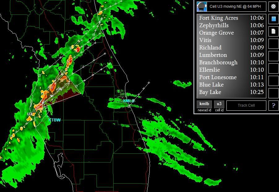
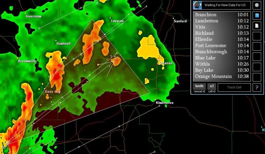
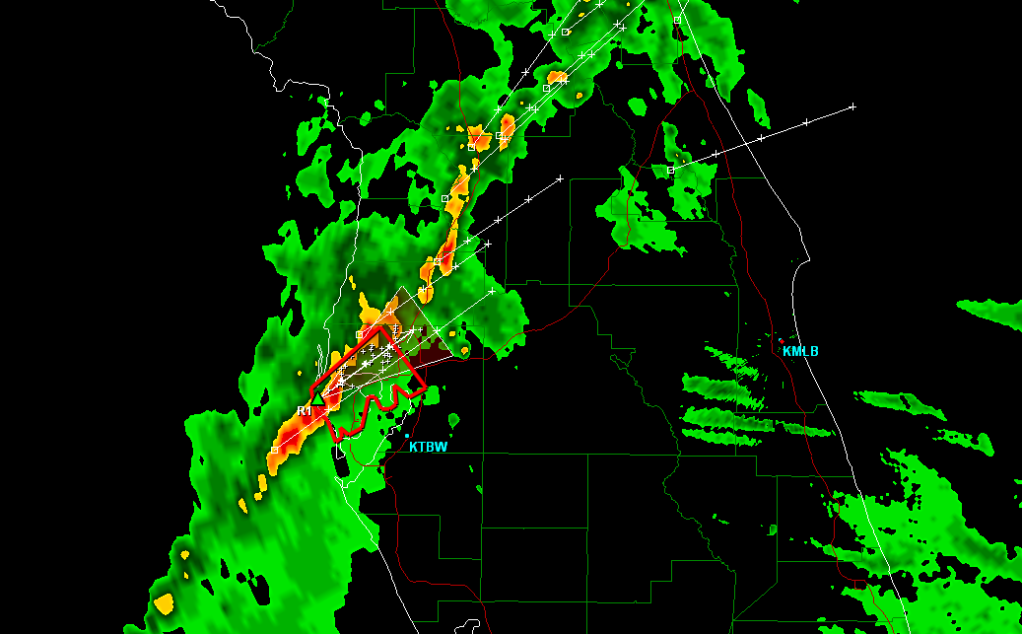
I am Reporting to you that a Line of Severe Thunderstorms are heading toward WDW. I am estimating it to hit the WDW area currently at 10-1am. This storm is moving North East at 26mph right now. Last Warning from the National Weather Service about this Storm
Code:
WUUS52 KTBW 030201
SVRTBW
FLC057-103-030230-
/O.NEW.KTBW.SV.W.0104.091203T0201Z-091203T0230Z/

BULLETIN - EAS ACTIVATION REQUESTED
SEVERE THUNDERSTORM WARNING
NATIONAL WEATHER SERVICE TAMPA BAY AREA - RUSKIN FL
901 PM EST WED DEC 2 2009

THE NATIONAL WEATHER SERVICE IN RUSKIN HAS ISSUED A

* SEVERE THUNDERSTORM WARNING FOR...
  NORTHWESTERN HILLSBOROUGH COUNTY IN FLORIDA.
  SOUTHERN PINELLAS COUNTY IN FLORIDA.

* UNTIL 930 PM EST

* AT 900 PM EST...NATIONAL WEATHER SERVICE DOPPLER RADAR INDICATED A
  SEVERE THUNDERSTORM CAPABLE OF PRODUCING DAMAGING WINDS IN EXCESS
  OF 60 MPH.  THIS STORM WAS LOCATED NEAR MADEIRA BEACH...OR 6 MILES
  SOUTHWEST OF SEMINOLE...AND MOVING NORTHEAST AT 25 MPH.

* THE SEVERE THUNDERSTORM WILL BE NEAR...
  MADEIRA BEACH.
  GULFPORT.
  KENNETH CITY.
  PINELLAS PARK.

PRECAUTIONARY/PREPAREDNESS ACTIONS...

A TORNADO WATCH REMAINS IN EFFECT FOR THE WARNED AREA. IF A TORNADO
IS SPOTTED...ACT QUICKLY AND MOVE TO A PLACE OF SAFETY IN A STURDY
STRUCTURE...SUCH AS A BASEMENT OR SMALL INTERIOR ROOM.

A TORNADO WATCH REMAINS IN EFFECT UNTIL 400 AM EST THURSDAY MORNING
FOR SOUTHWESTERN FLORIDA.

&&

LAT...LON 2816 8254 2791 8232 2787 8240 2792 8247
      2784 8246 2782 8249 2782 8253 2787 8256
      2787 8259 2774 8262 2771 8268 2774 8272
      2770 8271 2768 8274 2777 8278 2782 8284
      2790 8286
TIME...MOT...LOC 0201Z 238DEG 23KT 2778 8284

$$
Radar at 9:05pm with custom Radar guide
WDW1-1.png

Untitled-3copy.jpg
 

Monty

Brilliant...and Canadian
In the Parks
No
The storm warning says it was at Madeira Beach at 9PM, That's 90 miles from WDW, travelling North East at 26MPH it might hit WDW after midnight, if there's anything left of it by the time it gets that far inland. :shrug:

The warning doesn't even mention Central Florida.
 

Gringrinngghost

Well-Known Member
Original Poster
Last my update on the storm, is that the storm is moving 38mph going North East. Accuweather on twitter @Breakingweather: Severe weather, possible tornadoes impacting areas from southeast Virginia to central Florida. Take cover if threatening weather approaches.
 

Figment82

Well-Known Member
Under a tornado watch right now, has been raining lightly off and on, and the winds picking up. Not too bad right now...
 

PhotoDave219

Well-Known Member
The storm warning says it was at Madeira Beach at 9PM, That's 90 miles from WDW, travelling North East at 26MPH it might hit WDW after midnight, if there's anything left of it by the time it gets that far inland. :shrug:

The warning doesn't even mention Central Florida.

According to the NWS and @wdwmagic on Twitter, the Theme Parks area and under a Tornado Watch. (Which means that conditions are right for the formation of said storms)
 

Gringrinngghost

Well-Known Member
Original Poster
This storm Cell is now going NE at 64mph. My Software say it will be at Bay Lake by 10:25. My first prediction of Between 10 and 10:30pm. Jim Cantore Reported the Following on twitter "Line coming into Tampa/St Pete seems to have lost its steam as it came ashore. Not writing it off but not impressed right now."\
wdw2.jpg

Untitled-3copy.jpg

Tornado Watch This is issued by the National Weather Service when conditions are favorable for the development of tornadoes in and close to the watch area. Their size can vary depending on the weather situation. They are usually issued for a duration of 4 to 8 hours. They normally are issued well in advance of the actual occurrence of severe weather. During the watch, people should review tornado safety rules and be prepared to move a place of safety if threatening weather approaches. A Tornado Watch is issued by the Storm Prediction Center (SPC) in Norman, Oklahoma. Prior to the issuance of a Tornado Watch, SPC will usually contact the affected local National Weather Forecast Office (NWFO) and they will discuss what their current thinking is on the weather situation. Afterwards, SPC will issue a preliminary Tornado Watch and then the affected NWFO will then adjust the watch (adding or eliminating counties/parishes) and then issue it to the public. After adjusting the watch, the NWFO will let the public know which counties are included by way of a Watch Redefining Statement. During the watch, the NWFO will keep the public informed on what is happening in the watch area and also let the public know when the watch has expired or been cancelled.
 

Gringrinngghost

Well-Known Member
Original Poster
This storm is now moving at 59mph. Here is an Updated Radar Image Zoomed in.
wdw3.jpg

Untitled-3copy.jpg

UPDATE: THIS STORM IS NOW MOVING AT 54MPH, AND EXPECTING NOW TO HIT BAYLAKE AT 10:35
 

EpcotServo

Well-Known Member
Pssst! Avast there! Keep a weather eye open mates, and hold on tight...with both hands if you please. There be Squalls ahead! And Davy Jones' waiting for them what don't obey...
 

WDW1974

Well-Known Member
Perhaps, we need a current WDW weather board here.

A friend emailed an hour ago to let me know it was 'chilly' at DL this evening.
 

Tom

Beta Return
I guess I don't shudder when I look at that image because I live in Indiana. There are many times in the Spring and Summer when the entire state is covered in "Yellow" and "Red". This is just a thunderstorm crossing the state - not a hurricane :p
 

palmage

Member
Wasn't much of a storm for all hype it was getting here.
Nothing but a little wind and some rain.
It was over in an hour.
 

Register on WDWMAGIC. This sidebar will go away, and you'll see fewer ads.

Back
Top Bottom