SEVERE WEATHER: TORNADO WATCH LIKELY May 24 2017

Gringrinngghost

Well-Known Member
Original Poster
UPDATE:

URGENT - IMMEDIATE BROADCAST REQUESTED
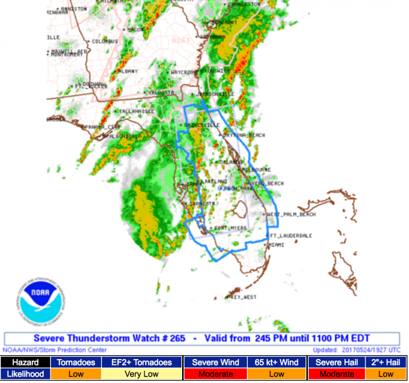
Severe Thunderstorm Watch Number 265
NWS Storm Prediction Center Norman OK
245 PM EDT Wed May 24 2017

The NWS Storm Prediction Center has issued a

* Severe Thunderstorm Watch for portions of
Florida peninsula
Coastal Waters

* Effective this Wednesday afternoon and evening from 245 PM
until 1100 PM EDT.

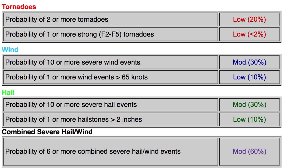
* Primary threats include...
Isolated damaging wind gusts to 70 mph possible
Isolated large hail events to 1.5 inches in diameter possible
A tornado or two possible

SUMMARY...Thunderstorms developing along and ahead of a convective
outflow boundary now advancing inland off the Gulf coast are
expected to increase in coverage and intensity across the interior
and eastern peninsula through this evening. Strongest activity may
be accompanied by severe wind gusts and hail, with some risk of a
tornado or two, mainly near Atlantic coastal areas.

The severe thunderstorm watch area is approximately along and 60
statute miles east and west of a line from 5 miles west of St
Augustine FL to 20 miles southeast of Fort Meyers FL. For a complete
depiction of the watch see the associated watch outline update
(WOUS64 KWNS WOU5).

PRECAUTIONARY/PREPAREDNESS ACTIONS...

REMEMBER...A Severe Thunderstorm Watch means conditions are
favorable for severe thunderstorms in and close to the watch area.
Persons in these areas should be on the lookout for threatening
weather conditions and listen for later statements and possible
warnings. Severe thunderstorms can and occasionally do produce
tornadoes.

&&
Screen Shot 2017-05-24 at 3.30.40 PM.png
Screen Shot 2017-05-24 at 3.30.31 PM.png
 
Last edited:

Gringrinngghost

Well-Known Member
Original Poster
Like any of us really know what 19z and 21z and SBCAPE values greater than 2000 J/kg mean. Geez. Just say rain and high winds.
SBCAPE = Surface level and the cape value means the atmosphere is moderately unstable. CAPE represents potential energy, and will only be used should an air parcel be lifted to the level of free convection.
 

ToTBellHop

Well-Known Member
Forgive me, but I feel a tornado watch is marginally more concerning. I don't recall tornado watches daily on my trips. I remember some (and some actual tornados) with winter cold fronts and others with tropical systems. But perhaps I wasn't paying close enough attention.

It sounds to me like the atmosphere is particularly unstable for May.
 

Oddysey

Well-Known Member
Forgive me, but I feel a tornado watch is marginally more concerning. I don't recall tornado watches daily on my trips. I remember some (and some actual tornados) with winter cold fronts and others with tropical systems. But perhaps I wasn't paying close enough attention.

It sounds to me like the atmosphere is particularly unstable for May.

Agreed. I live in Central Florida and the storms are anticipated to be especially severe and last from the afternoon into the night. The storms are not even officially here yet and there are some pretty significant wind gusts. While I do not think a tornado is going to damage the parks today, I also do not believe today would be a great day for a WDW visit.
 

Gringrinngghost

Well-Known Member
Original Poster
Agreed. I live in Central Florida and the storms are anticipated to be especially severe and last from the afternoon into the night. The storms are not even officially here yet and there are some pretty significant wind gusts. While I do not think a tornado is going to damage the parks today, I also do not believe today would be a great day for a WDW visit.
You also have to see it from this. Disney and Universal both have media events for new properties today
 

LAKid53

Official Member of the Girly Girl Fan Club
Premium Member
We've been under a tornado watch up here in North Florida since yesterday. NWS says today's weather will be worse than yesterday's.

And for all you naysayers, a tornado watch is a tad more than the typical afternoon thunderstorm. We're projected to get rains of up to 7 inches and winds in the 60-70 mph range.

Also known as a thunderstorm in Florida.

Uh, no.
 

KrzyKtty

Well-Known Member
We've been under a tornado watch up here in North Florida since yesterday. NWS says today's weather will be worse than yesterday's.

And for all you naysayers, a tornado watch is a tad more than the typical afternoon thunderstorm. We're projected to get rains of up to 7 inches and winds in the 60-70 mph range.


Uh, no.
It is a bit more common where I am from, but that is the coastal region of SC. Summer storms down here get crazy. :eek:
 

HauntedPirate

Park nostalgist
Premium Member
In case anyone is wondering what a Tornado Watch actually means:

"A tornado watch is issued when weather conditions are favorable for the development of severe thunderstorms that are capable of producing tornadoes. A tornado watch therefore implies that it is also a severe thunderstorm watch."

To all in and around the affected areas - Stay safe!!!
 

LAKid53

Official Member of the Girly Girl Fan Club
Premium Member
It is a bit more common where I am from, but that is the coastal region of SC. Summer storms down here get crazy. :eek:

Yes, summer storms can have winds and heavy rainfall, but a tornado watch is an indication storms are configured such that they are capable of producing tornados. I've lived in Florida over 50 years (46 in NW Florida) - I don't remember when we've been under a tornado watch two days in a row....
 

KrzyKtty

Well-Known Member
Granted with all of this rain between yesterday and today, students and residents downtown will be taking canoes home. If the sky just thinks about raining, downtown goes underwater. :(

And you are right, better to be aware than not. Just don't freak out over it. :)
 

KrzyKtty

Well-Known Member
Yes, summer storms can have winds and heavy rainfall, but a tornado watch is an indication storms are configured such that they are capable of producing tornados. I've lived in Florida over 50 years (46 in NW Florida) - I don't remember when we've been under a tornado watch two days in a row....
Our Summer storms come with Tornado watches often enough, warnings are more rare though. We got over a dozen decent sized tornados and water spouts in our area last summer. Large hail can also be quite regular in the summer time too. Granted about half of those tornadoes were from the hurricanes/tropical storms.

Either way, it is best to be safe. Probably just got to used to it, which isn't ever a good thing in all fairness.
 

LAKid53

Official Member of the Girly Girl Fan Club
Premium Member
Our Summer storms come with Tornado watches often enough, warnings are more rare though. We got over a dozen decent sized tornados and water spouts in our area last summer. Large hail can also be quite regular in the summer time too. Granted about half of those tornadoes were from the hurricanes/tropical storms.

Either way, it is best to be safe. Probably just got to used to it, which isn't ever a good thing in all fairness.

We typically don't get tornado watches or warnings with thunderstorms, even severe ones. But we are under an all day tornado watch, just like yesterday, so I'm paying a bit more attention to the sky. Had a tornado pass about a mile up the road from my house a few years ago...fortunately it was only an F1. And when the area actually gets tornados, they have a tendency to bypass us and hit South Georgia....poor them.

However, we do need the rain.....thank goodness I live at the TOP of the hill - all the rain will flood my neighbor's property....
 

Register on WDWMAGIC. This sidebar will go away, and you'll see fewer ads.

Back
Top Bottom